New Orleans Comprehensive Zoning Ordinance
Printed: 4/28/2024 5:57:16 PM
Article 1
Title, Purpose, Intent, & Application
1.1 Title
This Ordinance is known, referred to, and cited as the “Comprehensive Zoning Ordinance of the City of New Orleans,” as amended.
1.2 Purpose
The purpose of this Ordinance includes the following:
A. To encourage and promote, in accordance with present and future needs, the public health, safety, and welfare of the citizens of the City of New Orleans.
B. To provide for efficiency and economy in the process of development.
C. To provide for the appropriate use of land.
D. To preserve and enhance the value of structures, communities, and neighborhoods that constitute the distinct places within the city.
E. To provide for preservation, protection, development, and conservation of natural resources.
F. To promote the principles of sustainability and resilience.
G. To provide for functional public utilities and facilities, and for the convenience of traffic and circulation of people and goods.
H. To provide for promotion of the civic amenities of beauty and visual interest, for preservation and enhancement of historic buildings and places, and for promotion of large-scale developments as means of achieving unified civic design.
I. To ensure that the policies set forth in City's Master Plan are implemented by the land use regulations and are consistent with the goals set forth in the Master Plan.
Adopted by Ord. No. 29,126, §1, Aug. 12, 2022, Zoning Docket 16/22
1.3 Intent
The objectives of this Ordinance are accomplished by establishing zoning districts, which regulate the location and use of structures, signs, water and land areas for agriculture, trade, industry, and residential use. These zoning districts also regulate, limit, or determine the height, bulk, and access to light and air of structures, the area of yards and other open spaces, the density of use, and the standards for site organization and layout. Zoning district regulations and the Official Zoning Map have been designed with reasonable consideration of, among other things, the character of the districts and their suitability for particular uses.
1.4 Applicability
1.4.A Territorial Application
This Ordinance applies to all land, uses, structures, and areas within the boundaries of the City of New Orleans, as defined in the Home Rule Charter of the City of New Orleans.
1.4.B General Application
In their interpretation and application, the provisions of this Ordinance are the minimum requirements for the promotion and protection of the public health, safety and welfare, and are construed to achieve the purposes for which this Ordinance was adopted.
1.4.C Required Conformance with Ordinance
No portion or whole of any structure or land may be used or occupied, and no structure, in whole or in part, may be erected, constructed, reconstructed, moved, enlarged or structurally altered unless it conforms to the provisions of this Ordinance.
1.4.D Subdivisions Required to Conform with Ordinance
All subdivisions shall comply with the City of New Orleans Subdivision Regulations. Where conflicts occur with this Ordinance, as determined by the Executive Director of the City Planning Commission, the most restrictive regulations shall prevail.
1.4.E Applicability to Private Agreements
Where this Ordinance is more restrictive than a private agreement, this Ordinance controls. The City will not enforce any private agreements.
1.4.F Reasonable Accommodation
The City of New Orleans shall provide reasonable accommodations to persons with disabilities to ensure that persons with disabilities are provided equal opportunity to live in the dwelling of their choice (see Article 27.)
1.4.G Conflict with Other Laws and Regulations
Whenever these regulations contain an actual, implied or apparent conflict with other laws and regulations, including an internal conflict within this Ordinance, the more restrictive regulation applies, unless otherwise specified.
1.4.H Effect of Litigation
In the event a suit is filed in Civil District Court challenging any approval under the Comprehensive Zoning Ordinance, the time in which to complete the terms and conditions on said approval are tolled from the date suit is filed until there is a final judgement.
Adopted by Ord. No. 29,126, §1, Aug. 12, 2022, Zoning Docket 16/22
1.5 Transition Rules
In determining the applicability of this Ordinance, with respect to the previously applicable zoning regulations, the following rules apply.
1.5.A Existing Nonconforming Structures and Uses
A structure or use that is made nonconforming before the effective date of this Ordinance, but is made conforming by the provisions of this Ordinance or any subsequent amendment to this Ordinance, is lawful as of the effective date of this Ordinance or of any subsequent amendment to this Ordinance. However, any subsequent addition, enlargement or expansion of that structure or use is required to conform to the procedural and substantive requirements of this Ordinance.
1.5.B Existing Uses
1. If a structure or land is used in a manner that was classified as a permitted use prior to the effective date of this Ordinance, and now that use is classified as a conditional use as of the effective date of this Ordinance, that use is deemed a lawful nonconforming use. Any subsequent addition, enlargement, or expansion of that use shall conform to the requirements of this Ordinance.
2. If a structure or land is used in a manner that was classified as a conditional use prior to the effective date of this Ordinance, and that use is now classified as a permitted use as of the effective date of this Ordinance, that use is deemed a lawful permitted use. Any subsequent addition, enlargement, or expansion of that use shall conform to any Ordinance requirements for such permitted use and is no longer subject to the conditional use ordinance under which it was originally approved.
3. Planned developments, including previously adopted Residential Planned Community Districts, Central Business District Planned Community Districts, and Mixed-Use Planned Community Districts, shall follow the requirements of Section 4.4. Where a use within a planned development was classified as a conditional use prior to the effective date of this Ordinance, and that use is now classified as a permitted use as of the effective date of this Ordinance, that use is deemed a lawful permitted use. Any subsequent addition, enlargement, or expansion of that use shall comply with Paragraph 2 above.
1.5.C Certain Uses Rendered Nonconforming
If property is used in a manner that was a lawful use before the effective date of this Ordinance or any subsequent amendment to this Ordinance, and this Ordinance no longer classifies that use as either a permitted or conditional use in the zoning district in which it is located, that use is deemed a legal nonconforming use and is controlled by the provisions of Article 25.
1.5.D Certain Structures Rendered Nonconforming
If a structure existing on the effective date of this Ordinance or any subsequent amendment to this Ordinance was a conforming structure and was legally constructed before the effective date of this Ordinance or any subsequent amendment to this Ordinance, and such structure does not meet all standards set forth in this Ordinance, that structure is deemed a legal nonconforming structure and is controlled by the provisions of Article 25.
1.5.E Certain Lots Rendered Nonconforming
If a lot existing on the effective date of this Ordinance was a conforming lot before the effective date of this Ordinance or any subsequent amendment to this Ordinance, and such lot does not meet all standards set forth in this Ordinance, that lot is deemed a legal nonconforming lot and is controlled by the provisions of Article 25.
1.5.F Previously Issued Building Permits
If a building permit for a building or structure was lawfully issued prior to the effective date of this Ordinance or any subsequent amendment to this Ordinance, and if substantial construction has begun within one-hundred eighty (180) days of the issuance of that permit, the structure may be completed in accordance with the plans on the basis of which the building permit was issued and may, upon completion, be occupied under an occupancy permit for the use originally intended.
1.5.G Previously Granted Conditional Uses and Variances
- All conditional uses and variances granted prior to the effective date of this Ordinance or any subsequent amendment to this Ordinance remain in full force and effect, unless a conditional use is allowed as a permitted use or a variance was granted for a standard under the former ordinance that no longer exists or applies as of the effective date of this Ordinance.
- The recipient of the conditional use or variance may proceed to develop the property in accordance with the approved plans, including all conditions included as part of approval.
- If a structure or land is used in a manner that is classified as a conditional use prior to the effective date of this Ordinance and is classified as a permitted use subsequent to the adoption of this Ordinance, and the structure or land was granted a conditional use by the City Council, any provisos attached to the original conditional use shall no longer apply unless authorizing expanded permissions not allowable under this Ordinance.
- If a structure or land is used in a manner that is classified as a permitted use prior to the effective date of this Ordinance and subsequent to the adoption of this Ordinance, and the structure or land was granted a variance by the Board of Zoning Adjustments for a standard under the former ordinance that no longer exists, any provisos attached to the original variance shall no longer apply.
- If the recipient has failed to act on the conditional use or variance before the approval expires, including any periods of extension granted, the provisions of this Ordinance govern.
Adopted by Ord. No. 29,126, §1, Aug. 12, 2022, Zoning Docket 16/22
1.5.H Pending Applications
An application that has been received and is complete is subject to the rules in effect on the date the complete application was received.
1.6 Enforcement
1.6.A Purpose
If any structure is erected, structurally altered, extended, moved or maintained, or any structure or land is used in violation of this Ordinance, in violation of applicable licensing requirements for a particular use contained in the Code of the City of New Orleans, which violation(s) shall be deemed a violation of this Ordinance, the Director of the Department of Safety and Permits, or the Director’s designee, in addition to other remedies, may institute any appropriate actions or proceedings to prevent such unlawful erection, structural alteration, extension, moving, maintenance, use, or other violations, to restrain, correct, or abate violation, to prevent the occupancy of such buildings, structure, or land or to prevent any illegal act, conduct, business, or use in or about such premises. Each day such violation continues constitutes a separate violation.
1.6.B Penalties
The following persons may be found guilty of a misdemeanor punishable either by a fine, the minimum and maximum amounts as established in the Louisiana Revised Statutes, or not more than one-hundred fifty (150) days imprisonment, or both, or be held liable for a code violation as provided by Article II, Chapter 6 of the Code of the City of New Orleans, punishable by a fine or any other lawful measure(s) ordered by a hearing officer, for each and every day that such violation continues, and the correction of a violation does not restrain imposition of these penalties.
1. The owner or general agent of a structure or premises where a violation of any provision of these regulations has been committed or exists.
2. The lessee or tenant of an entire structure or entire premises where such general agent, lessee or tenant of any part of the structure or premises in which such violation has been committed or exists.
3. The general agent, architect, builder, contractor or any other person who commits, takes part in or who assists in any such violation or who maintains any structure or premises in which any such violation exists.
Adopted by Ord. No. 27,209, §1, Dec. 7, 2016, Zoning Docket 61/16
1.6.C New Violation Following Determination of Compliance
Following any judicial determination that a violation of this Ordinance has occurred and compliance has been rendered, the Director of the Department of Safety and Permits shall place in the records of the City a notation that compliance has been rendered. Any subsequent report of a violation of the regulations pertaining to the same or substantially the same matter constitutes a new violation and is subject to the same remedies herein provided.
1.7 Severability
If any section or provision of this Ordinance is declared by a court of competent jurisdiction to be invalid, such decision will not affect the validity of the Ordinance as a whole or any part thereof other than the part declared to be invalid.
1.8 Effective Date
The effective date of this Comprehensive Zoning Ordinance is ninety (90) days from the date of adoption of this Ordinance. The effective date is defined as that date at which the specific regulations of this Ordinance take effect and are enforced.
Article 2
Ordinance Administrators
2.1 Purpose
The purpose of this Article is to outline the specific powers of the different boards, commissions and officials as they relate to this Zoning Ordinance. This Article summarizes which boards, commissions, and officials make recommendations and grant approvals on zoning applications.
2.2 Conflict
If the provisions of this Article conflict with Article 4, the provisions of Article 4 control.
2.3 Designees
Certain officials within this section, such as the Executive Director of the City Planning Commission and the Director of the Department of Safety and Permits, are cited as having powers which may also be administered by a designee, indicated in this section by the language “Director’s designee.” The ability to direct powers to a designee applies to all actions throughout this Ordinance.
2.4 City Council
The City Council has the following powers, pursuant to applicable law:
A. To make final decisions on amendments to the Master Plan.
B. To make final decisions on zoning map and text amendment applications (Section 4.2).
C. To make final decisions on conditional use applications (Section 4.3).
D. To make final decisions on planned development applications (Section 4.4).
Adopted by Ord. No. 29,126, §2, Aug. 12, 2022, Zoning Docket 16/22
2.5 City Planning Commission
The City Planning Commission has the following powers, pursuant to this Ordinance:
A. To make recommendations on zoning map and text amendment applications (Section 4.2).
B. To make recommendations on conditional use applications (Section 4.3).
C. To make recommendations on planned development applications (Section 4.4).
D. To make final decisions on appeals of minor map adjustments of the Future Land Use Map by the Executive Director of the City Planning Commission (Section 4.7).
E. To make final decisions on appeals of interpretations of the Future Land Use Map by the Executive Director of the City Planning Commission (Section 4.10).
F. To make final decisions on appeals on those development plan and design review decisions reviewed and approved solely by Executive Director of the City Planning Commission (Section 4.5).
2.6 Board of Zoning Adjustments
The Board of Zoning Adjustments has the following powers, pursuant to applicable law:
A. Hear and determine appeals from applicants who have been refused building permits because of a violation or conflict with the zoning ordinance or the official map of the City (Section 4.8).
B. Hear and decide appeals where error is alleged in any order, requirement, decision, or determination made by an administrative official in the enforcement of the zoning ordinance of the City (Section 4.8)
C. Permit variations from the zoning regulations in classes of cases or situations and in accordance with the principles, conditions, and procedures specified in and subject to the limitations imposed by the zoning ordinances of the City (Section 4.6)
Adopted by Ord. No. 29,126, §2, Aug. 12, 2022, Zoning Docket 16/22
2.7 Design Advisory Committee
The Design Advisory Committee has the following powers, pursuant to this Ordinance, relevant Chief Administrative Officer Policy Memoranda and the City Planning Commission’s Administrative Rules, Policies and Procedures:
A. To make recommendations on development plan and design review applications to the City Planning Commission and/or its staff when required as a condition of development approval (Section 4.5).
2.8 Executive Director of the City Planning Commission
The Executive Director of the City Planning Commission, or the Director’s designee, has the following powers, pursuant to this Ordinance:
A. To make final decisions on development plan and design review applications when required as a condition of development approval (Section 4.5).
B. To make final decisions on minor map adjustments to the Future Land Use Map (Section 4.7).
C. To make final decisions on requests for interpretations of the Official Zoning Map (Section 4.10).
D. To make final decisions on hospital sign design review approved through the IMP (Section 15.5.A.2)
Adopted by Ord 28937 MCS, 2-17-22, ZD 82/21
2.9 Director of the Department of Safety and Permits
The Director of the Department of Safety and Permits, or the Director’s designee, has the following powers, pursuant to this Ordinance:
A. To make final decisions on requests for zoning verifications (Section 4.9).
B. To make final decisions on requests for zoning text interpretations (Section 4.10).
C. To make final decisions on applications for sign permits (Section 4.11).
D. To inspect structures or the use of land to determine compliance with this Ordinance and order corrective action in case of any violation
E. To enforce all zoning regulations and provisos imposed in conjunction with the approval of conditional uses ordinances, planned unit development ordinances, and variances.
F. To revoke, suspend, or cancel any permit that has been violated or issued in violation of this Ordinance.
2.10 Vieux Carre Commission
Within the Vieux Carré Historic District, no exterior work on a structure is permitted unless a permit has been issued by the Vieux Carré Commission. Provisions for the Vieux Carré Commission and their permit requirements and procedures are located in the City Code. The Vieux Carré Commission shall have no jurisdiction over use, except as provided in the paragraph below.
Within the Vieux Carré Historic District, no occupancy permit shall be issued by the Director of Safety and Permits, for any change in the use of any existing building until and unless a special permit shall have been issued by the Vieux Carré Commission, except that where no change of exterior appearance is contemplated such permit by the Vieux Carré Commission shall not be required. Where any change in exterior appearance is contemplated, the Vieux Carré Commission shall hold a hearing, and if it approves such change, it shall issue a special permit to continue the same use, or for any other use not otherwise prohibited in the district, subject to the following conditions and safeguards:
1. The historic character of the Vieux Carré shall not be injuriously affected.
2. Signs which are garish or otherwise out of keeping with the character of the Vieux Carré shall not be permitted.
3. Building designs shall be in harmony with the traditional architectural character of the Vieux Carré.
4. The value of the Vieux Carré as a place of unique interest and character shall not be impaired.
2.11 Historic District Landmarks Commission
A. The New Orleans Historic District Landmarks Commission and the Central Business District Historic District Landmarks Commission regulate local historic districts outside of the Vieux Carré Historic District. Prior to commencing any exterior work within a local historic district or on a designated or nominated landmark outside of the designated local historic districts, the applicant shall refer to and comply with the Historic District Landmarks Commission procedures in the City Code. The Historic District Landmarks Commission shall have no jurisdiction over use.
B. The Historic District Landmarks Commission makes final decisions on requests for classic sign designation (Section 24.15).
Article 3
Administrative Procedures
3.1 Purpose
The purpose of this Article is to outline the general application, notice, and public hearing procedures for the applications and approvals found within this Ordinance.
3.2 Application
3.2.A Filing of Applications
1. All applications shall be filed with the appropriate official as described in Table 3-1: Filing of Applications:
Table 3-1: Filing of Applications
|
APPLICATION
|
OFFICIAL OR HIS/HER DESIGNEE
|
|
Zoning Text & Map Amendments
|
Executive Director of the City Planning Commission
|
|
Conditional Use
|
Executive Director of the City Planning Commission
|
|
Planned Development
|
Executive Director of the City Planning Commission
|
|
Site Plan & Design Review
|
Executive Director of the City Planning Commission
|
|
Variances
|
Executive Director of the City Planning Commission
|
|
Minor Map Adjustments of Future Land Use Map
|
Executive Director of the City Planning Commission
|
|
Minor Map Adjustments of Official Zoning Map
|
Director of the Department of Safety & Permits
|
|
Interpretation of Future Land Use Map
|
Executive Director of the City Planning Commission
|
|
Zoning Appeals
|
Executive Director of the City Planning Commission
|
|
Interpretation of Zoning Map
|
Executive Director of the City Planning Commission
|
|
Interpretation of Zoning Text
|
Director of the Department of Safety & Permits
|
|
Zoning Verification
|
Director of the Department of Safety & Permits
|
|
Sign Permit
|
Director of the Department of Safety & Permits
|
| Reasonable Accommodations |
Executive Director of the City Planning Commission |
2. All applications shall be on forms provided by the City and in the format and number of copies as required by the instructions. The application shall include any and all information, plans, and data specified within Article 4.
Adopted by Ord. No. 29,126, §3, Aug. 12, 2022, Zoning Docket 16/22
3.2.B Completeness Review
1. The official in Table 3-1 charged with receiving applications shall review the application to ensure that all required submittals are included in the application and determine whether the application is complete. The appropriate official shall notify the applicant that the application is complete or incomplete within ten (10) days from the date of submittal.
2. If the application is deemed incomplete, the official will not process the application until the deficiencies are remedied. Once an application is deemed complete, the application will be placed on the first available docket or forwarded to the appropriate official as appropriate. An application that is not made complete by the applicant within one hundred eighty (180) days of the date of submittal will be void and discarded. An application initiated by Council motion that is not made complete within one hundred eighty (180) days of the date of the motion will be void and discarded.
3. An application is deemed complete if the official fails to reject it and notify the applicant of the deficiencies within ten (10) days and it shall be docketed. However, it may not be complete for the purposes of review and a determination of completeness does not constitute approval of the application. The appropriate board, commission, or official may also require the applicant to supplement the application with additional information.
4. A new determination of completeness is required if the applicant materially changes the application from the prior submittal.
Adopted by Ord. No. 29,126, §3, Aug. 12, 2022, Zoning Docket 16/22
3.2.C Required Fees
Every application shall be accompanied by the required filing fee. Failure to pay fees when due is grounds for refusing to process the application. However, applications initiated by the City may be exempt from fees. If it is the City Council’s intent to waive the fee, the waiver and the fee amount shall be stated in the motion initiating the request.
3.2.D Withdrawal of Application
An applicant may withdraw an application as provided below. There will be no refund of fees. Requests for withdrawal shall be in writing by the applicant or legally authorized agent. Applications initiated by the City Council are also subject to these withdrawal provisions.
1. Applications for a zoning text or map amendment, conditional use, and planned development may be withdrawn prior to recommendation by the City Planning Commission without prejudice or limit. If withdrawn after the recommendation by the City Planning Commission, but before a decision by the City Council, the application may not be resubmitted for two (2) years from the date the applicant submits the withdrawal notice.
2. Applications for variances may be withdrawn prior to a decision by the Board of Zoning Adjustments without prejudice and may thereafter be resubmitted without limit.
3. Applications for a zoning appeal may be withdrawn prior to a decision by the Board of Zoning Adjustments without prejudice. However, if an application that was withdrawn is resubmitted, the new submittal shall still be filed within forty-five (45) days of the date the decision being appealed was rendered.
3.2.E Resubmittal of Denied Applications
1. An application for a zoning text or map amendment, conditional use, planned development, or variance that has been denied will not be reviewed or heard within two (2) years of the date of denial unless substantial new evidence is available or a significant mistake of law or of fact affected the prior denial. The official charged with receiving applications in Table 3-1 shall decide whether the subsequent application is appropriate for resubmittal before expiration of the two (2) year wait requirement.
2. An application resubmitted earlier than two (2) years from the date of denial shall include a detailed statement of the grounds justifying its consideration.
3. Unless substantial new evidence is available or a significant mistake of law or fact affected the prior denial, the official shall return the application to the applicant and it shall not be docketed.
4. The limitations of this section do not apply when the City initiates the application.
Adopted by Ord. No. 29,126, §3, Aug. 12, 2022, Zoning Docket 16/22
3.3 Notice
3.3.A Published Notice
For all applications that require a public hearing, a notice shall be published once a week for three (3) consecutive weeks in the official journal of the City of New Orleans, as defined in the City Code, with the first publication of notice at least twenty (20) days before the date of hearing. Each notice shall set forth the date, time, place, and purpose of the public hearing, the name of the applicant, and identification of the subject property.
3.3.B Mailed Notice
1. Mailed notice is required for all public hearings required by this ordinance, excluding those for zoning text amendments and for zoning amendments initiated by the City Council covering multiple squares.
2. Mailed notice for public hearings held by the City Planning Commission shall be sent by regular mail at least fifteen (15) days before the public hearing to the following individuals and entities. Mailed notice for public hearings held by the Board of Zoning Adjustments shall be sent by regular mail at least fifteen (15) days before the public hearing to the following individuals and entities.
a. The owner of record of the property, as indicated in the records of the Orleans Parish Assessor’s Office, and all persons expressly authorized in writing by the owner to file the application.
b. The owners of record of all properties, as indicated in the records of the Orleans Parish Assessor’s Office, located within three hundred (300) feet of the property lines of the subject property. However, for public hearings involving a site of twenty-five thousand (25,000) square feet or more in area or a development of twenty-five thousand (25,000) square feet or more in floor area, such notice shall be expanded to all properties within six-hundred (600) feet of the property lines of the subject property.
c. The occupants of all properties indicated in items i and ii above, wherever the mailing address of the property owner as indicated in the records of the Orleans Parish Assessor is different from the address of the property.
d. Any neighborhood association with boundaries within which any portion of the subject property is located. For the purposes of this section, the boundaries of a neighborhood association shall be as provided on its registration form in the office of the City Planning Commission.
3. The notice shall set forth the name of the applicant, the date, time, place, and purpose of the hearing, and identification of the subject property.
Adopted by Ord. No. 29,126, §3, Aug. 12, 2022, Zoning Docket 16/22
3.3.C Posted Notice
Posted notice for public hearings is required as follows in Table 3-2: Posted Notice for Pubic Hearing. Section 3.3.C.1 below describes required notice when required to be posted by the applicant and Section 3.3.C.2 below describes required notice when required to be posted by the Department of Safety and Permits.
Table 3-2: Posted Notice for Public Hearing
|
ZONING APPLICATION
|
POSTED BY APPLICANT (SECTION 3.3.C.1)
|
POSTED BY DEPARTMENT OF SAFETY & PERMITS (SECTION 3.3.C.2)
|
|
Zoning Map Amendment – Initiated by Applicant
|
X
|
|
|
Zoning Map Amendment – Initiated by City
|
|
X
|
|
Conditional Use
|
X
|
|
|
Planned Development
|
X
|
|
|
Variance
|
X
|
|
|
Property-Specific Zoning Appeal
|
|
X
|
3.3.C.1 Posted Notice by Applicant
a. A notification sign shall be installed by the applicant at least fifteen (15) consecutive days prior to the public hearing.
b. Such notification sign shall meet the following requirements:
i. The sign shall be an official notification sign provided by the City.
ii. The sign shall be posted at a prominent location on the subject property near the sidewalk or public right-of-way, and shall be visible to passing pedestrians and motorists. If it is not feasible to post a notification sign on a subject property for whatever reason, a notification sign shall be posted within the public right-of-way adjacent to the property at a location approved by the Department of Safety and Permits. For properties with more than one (1) street frontage, the applicant is required to post one (1) sign visible from each street frontage.
iii. The applicant shall photograph the required sign(s) after it has been posted on the subject property. A copy of the photograph shall be submitted to City Planning Commission staff.
c. The sign shall indicate that the site is the subject of a zoning application and shall provide contact information for the office of the City Planning Commission to obtain further information.
Adopted by Ord. No. 27,222, §1, Dec. 20, 2016, Zoning Docket 99/16
3.3.C.2 Posted Notice by the Department of Safety and Permits
a. Notification signs posted by the Department of Safety and Permits shall meet the following requirements:
i. The notification signs shall be no less than eleven (11) inches by seventeen (17) inches in size and shall be posted at the two (2) corner intersections of the block face on which the subject property is located, or by any other means, method, or placement deemed appropriate by the Executive Director of the City Planning Commission or the Director of the Department of Safety and Permits to effect the intended public notice.
ii. The sign shall indicate the type of application, the address of the subject property, and the day, date, time, and place of the public hearing.
3.3.D Validity of Defective Notice
1. No action on any application submitted in accordance with this Ordinance shall be declared invalid by reason of any defect in any of the following:
a. The publication of the notice of the purpose or subject matter and the time and place of the hearing if the published notice gives reasonable notification of its purpose, subject matter, substance, or intent.
b. The posting or display of a notification sign if evidence of installation of the sign is presented.
c. The mailing of notice to the individuals and entities within the vicinity of the site as indicated above.
d. The mailing of notice of the Neighborhood Participation Program.
2. Any defect in or failure to adhere to any discretionary forms of notification shall not form a basis for declaring invalid any ordinance or City Council action on any zoning matter.
3. No denial by the City Council of any application, petition, or other zoning matter requiring notice shall be declared invalid by reason of any defect in any form of public notice, if the applicant has received notice of the time, date, and place of the hearing.
4. No Neighorhood Participation Program notice shall be declared invalid for failure to properly notice a required individual or entity if the individual or entity waives the notice requirement.
Adopted by Ord. No. 29,126, §3, Aug. 12, 2022, Zoning Docket 16/22
3.4 Public Hearing
3.4.A Conduct of the Public Hearing
When a public hearing is required, the place, date, and time for the hearing will be established, and notice of such hearing is required in accordance with Section 3.3. The public hearing will be conducted in accordance with the rules and regulations of the body conducting the hearing.
3.4.B Continuances
The Chair, with approval of the body conducting the hearing, may continue the public hearing. No new mailed notice is required to reopen the hearing if a hearing is continued to a date specified, provided that a public announcement of the future date, time, and place of the continued hearing is made at the first hearing and placed in the minutes. Publication of the agenda shall satisfy the notice requirements.
Article 4
Applications & Approvals
4.1 Purpose
The purpose of this Article is to delineate the procedures and requirements, and approval standards that apply to each zoning application and approval.
4.2 Zoning Text and Map Amendments
4.2.A Purpose
The regulations imposed and the districts created and mapped under the authority of this Ordinance may be amended by the City Council in accordance with the provisions of this article.
4.2.B Initiation
Zoning text and map amendments are initiated as follows:
1. The City Council may initiate a zoning text or map amendment by adoption of a motion.
2. A property owner in the city or a person expressly authorized in writing by an owner may file an application for a text amendment.
3. A property owner in the city or a person expressly authorized in writing by the owner may file an application for a zoning map amendment for the area of land for which the map amendment is requested.
Adopted by Ord. No. 29,126, §4, Aug. 12, 2022, Zoning Docket 16/22
4.2.C Authority
The City Council shall take formal action on requests for zoning text or map amendments after receiving a recommendation from the City Planning Commission, in accordance with Sections 5-406 and 5-407 of the City Charter.
4.2.D Procedure
4.2.D.1 Submittal of Application
a. All applications shall be filed with the Executive Director of the City Planning Commission in accordance with the requirements of Section 3.2 and reviewed for completeness by the Executive Director.
b. Amendments initiated by the City Council require a complete application, but may be exempt from fees. If it is the City Council’s intent to waive the fee, the waiver and the fee amount shall be stated in the motion initiating the request. Applications may also be exempt from Neighborhood Participation Program requirements for good cause. If it is the intent of the City Council to waive the NPP requirement, that should be stated in the motion initiating the request.
Adopted by Ord. No. 29,126, §4, Aug. 12, 2022, Zoning Docket 16/22
4.2.D.2 Pre-Application Meeting and Project Neighborhood Participation Program
All applications for zoning text and map amendments shall include a Project Neighborhood Participation Program (Project NPP). Zoning text and Zoning map amendments covering less than one city square or its equivalent are subject to the Project NPP. Zoning map amendments covering more than one city square or its equivalent are subject to a Project NPP meeting requirement, although required notice of the meeting shall only be through registered neighborhood associations and an electronic City notification system such as NoticeMe or another similar system. Until all required NPP documents are submitted to CPC staff, including the meeting notice letter, sign-in sheets, and NPP meeting summary, the request will not be deemed complete for the purpose of a completeness review as provided in Section 3.2.B. The City Council may require the party of interest to undergo the NPP process prior to the motion being acted on by the City Council. During a time of declared emergency by the Governor or Mayor, when in-person meetings are not an available option, the City Planning Commission Director shall be authorized to require teleconferencing, virtual, or other remote meeting formats to satisfy NPP requirements. The City Planning Commission Director is authorized to make a determination that an Overlay District text amendment is minor if it does not expand entitlements that increase intensity or density of uses in a manner that could negatively impact adjacent residential districts. Minor text amendments shall not be subject to the NPP process. However, the impacted district Councilmember or At-Large Councilmember may require an NPP by the applicant for minor text amendments.
a. Applicants shall first meet with the staff of the City Planning Commission to become familiar with the procedure and approval standards for zoning text and map amendments and to obtain guidance on the requirements of the Project NPP.
b. The Project NPP shall include the following information:
i. A brief description of the proposal. Map amendment applications shall include the type of land use request, the name of the existing and proposed zoning district, and the article of the Comprehensive Zoning Ordinance. Text amendment applications shall include the citation and existing language of the Comprehensive Zoning Ordinance, if applicable, the proposed changes or additions to the language of the Comprehensive Zoning Ordinance and which zoning district(s) the amendment would affect.
ii. For map amendments, an outlined area map and a contact list for notifying the individuals and entities identified in Section 3.3.
iii. A general description of how parties on the contact list will receive information on the project, including a statement as to which public notification techniques will be used for the project.
iv. A general description of how parties on the contact list will be informed of any changes or amendments to the proposed project after the applicant’s initial contact.
v. A statement as to how those impacted by the proposal will be provided an opportunity to discuss the request if issues or questions should continue or suddenly arise.
c. The applicant shall provide the typed Project NPP and notice, including email notification to applicable registered neighborhood associations, of an opportunity for interested parties to attend a meeting to discuss the proposed application not less than fourteen (14) nor more than thirty (30) days after the date on which the applicant provides notification to the parties on the contact list. In addition, the applicant shall notify the City Planning Commission of the meeting date, time, and location not less than fourteen (14) days prior to the meeting. The applicant shall hold the meeting at the noticed time. The applicant shall distribute informational handouts to meeting attendees. The handouts shall include information about the requested zoning district, registering with City notification system(s), accessing application documents and NPP meeting summary reports. For the purposes of this section, meetings may be held in a physical location that is in accordance with the City Planning Commission's Administrative Rules, Policies and Procedures, except for zoning text and zoning map amendments covering at least one city square which may be allowed virtually or telephonically. The notice provided in accordance with this section shall include a brief description of the request and shall indicate the existing zoning classification of the subject property and the zoning classification the applicant intends to request and the citation of the zoning district name and article.
d. The applicant shall submit a Project NPP report with the application. The report shall provide the following information:
i. The names of the individuals and entities that were notified and the total number of number of people that participated in the process.
ii. A list of the concerns, issues, and problems expressed by the participants.
iii. A statement as to how each concern, issue, and problem is addressed and how the applicant intends to continue to address them. If the concern, issue, or problem is not being addressed, the applicant shall state the reasons.
iv. Copies of letters, affidavits, meeting invitations, newsletters, publications, and petitions received in support of or in opposition to the proposed project, and any other materials pertaining to the notification process.
v. The date, time, and location of all meetings held with interested parties or a statement indicating the reasons if no meeting was held. No information pertaining to any meeting held more than one hundred eighty (180) days prior to the submittal of the application shall be accepted as part of the Project NPP report, except where subsequent meetings with interested parties have occurred within the one hundred eighty (180) days preceding the submittal of the Project NPP report.
vi. A completed sign-in sheet that includes the names, addresses, and contact information for meeting attendees.
Adopted by Ord. No. 27,222, §2, Dec. 20, 2016, Zoning Docket 99/16; Ord. 28782 MCS, 9-23-21, ZD 46/21; Ord. 29084 MCS, 7-7-22, ZD 017/22
4.2.D.3 Action by City Planning Commission
a. The City Planning Commission shall conduct a public hearing on a proposed zoning amendment in accordance with Section 3.4 fifty (50) days from the date the application is docketed. Notice of the public hearing is required in accordance with Section 3.3.
b. After the close of the public hearing, the City Planning Commission shall make a recommendation. Based upon the evidence presented at the public hearing, the City Planning Commission shall evaluate the application against the applicable standards in Paragraph E below.
c. The City Planning Commission shall recommend approval, modified approval, or denial sixty (60) days from the opening of the public hearing. The City Planning Commission may also vote to defer action within City Charter required timeframes in cases where it discovers applicants have not submitted complete and accurate information, including but not limited to errors or omissions in following the Project NPP. The failure to resolve a finding of incomplete or inaccurate information may be grounds for recommending denial. If the City Planning Commission fails to act by a vote of the majority of the Commission members, the application will be forwarded to the City Council without recommendation of no legal majority. The City Planning Commission’s written recommendations, together with the staff report and recommendation, if any, shall be filed with the Clerk of the City Council.
Adopted by Ord. No. 27,222, §2, Dec. 20, 2016, Zoning Docket 99/16
4.2.D.4 Action by City Council
a. The City Council shall hold a public hearing in accordance with its rules and take action by motion of approval, modified approval, or denial sixty (60) days from receipt of a City Planning Commission recommendation. The City Council may not take official action upon any application requiring a recommendation of the City Planning Commission until the report of the Commission has been received or, if the City Planning Commission has failed to act by a vote of the majority of the Commission members, once the application has been forwarded to the City Council without recommendation.
b. If the City Council fails to take action by motion sixty (60) days from receipt of the City Planning Commission recommendation, the application is denied. If the application is forwarded to the City Council without recommendation from the City Planning Commission and the City Council fails to take action by motion sixty (60) days from the date it received the application, the application is denied.
c. If the City Council takes action by motion of approval or modified approval, the City Council may forward the motion to the City Law Department for preparation of an ordinance. If the ordinance is introduced by the City Council, the ordinance shall lay over for a minimum of twenty (20) days following introduction before the Council may adopt it. The City Council's adoption of a motion shall not be construed as an approval of a zoning matter unless and until an ordinance is introduced and adopted in accordance with the Charter; introduction of an ordinance does not indicate the City Council's approval of a zoning matter. Failure by the City Council to take action on a zoning ordinance within ninety (90) days of the date the City Council took action by motion shall mean that the application is denied.
4.2.E Approval Standards
The City Planning Commission recommendation and the City Council decision on any zoning text or map amendment are matters of legislative discretion. In making their recommendation and decision, the City Planning Commission and the City Council shall consider the standards in Table 4-1: Standards for Zoning Amendments below.
Table 4-1: Standards for Zoning Amendments
|
STANDARDS
|
MAP AMENDMENTS
|
TEXT AMENDMENTS
|
|
1. The proposed amendment is compatible with the Master Plan and Future Land Use Map.
|
X
|
X
|
|
2. The proposed amendment is compatible with the place designations of this Ordinance.
|
X
|
X
|
|
3.The proposed amendment is compatible with existing use and zoning of nearby property.
|
X
|
|
|
4. The proposed amendment promotes the public health, safety and welfare of the City.
|
X
|
X
|
|
5. The proposed amendment is a more suitable zoning classification for the property than the current classification.
|
X
|
|
|
6. Based upon the length of time that the property in question has been vacant, the proposed amendment is a more suitable zoning classification for the property than the current classification considered in the context of development in the area where the property is located.
|
X
|
|
|
7. The proposed amendment is compatible with the intent and general regulations of this Ordinance.
|
|
X
|
|
8. The proposed amendment corrects an error or omission, adds clarification to existing requirements, or reflects a change in policy.
|
X
|
X
|
|
9. The proposed amendment benefits the citizens of the City as a whole.
|
X
|
X
|
|
10. The proposed amendment provides a more workable way to achieve the intent and purposes of this Ordinance and the Master Plan.
|
X
|
X
|
|
11. The proposed amendment does not create a significant number of nonconformities.
|
X
|
X
|
|
12. The proposed amendment is compatible with the trend of development, if any, in the general area of the property in question.
|
X
|
|
4.2.F Appeals
An aggrieved party may appeal a City Council decision on a zoning map or text amendment to Orleans Parish Civil District Court within thirty (30) days of the date of the decision by the City Council, 30 days of the date upon which the City Council action is final resulting in a denial, takes no action on a matter at the last possible Council meeting before a deadline resulting in a denial, or the date the ordinance is adopted by the Council, thereby giving approval.
Adopted by Ord. No. 29,126, §4, Aug. 12, 2022, Zoning Docket 16/22
4.2.Chart Zoning Amendment Process

4.3 Conditional Uses
4.3.A Purpose
Within each zoning district, the use of land and structures are substantially uniform. However there are certain uses that, because of their unique characteristics, cannot be properly classified in certain districts without consideration, in each case, of the impact of those uses upon neighboring land and of the public need for the particular use at the particular location. These uses are allowed as conditional uses within the zoning districts. This section sets forth the standards used to evaluate proposed conditional uses and the procedures for approving conditional uses. The designation of a use in a zoning district as a conditional use does not constitute an authorization or assurance that such use will be approved. No conditional use may be established and no building permit may be issued for any use designated as a conditional use within a zoning district until a conditional use ordinance is adopted by the City Council and final drawings are submitted to and approved by the Executive Director of the City Planning Commission.
4.3.B Initiation
Conditional Use applications are initiated as follows:
1. The City Council may initiate a Conditional Use application by adoption of a motion.
2. A property owner in the city or a person expressly authorized in writing by the owner may file an application for a Conditional Use for the area of land for which the Conditional Use is requested. The application shall bear the signature and acknowledgment of the owner(s) or authorized agents of not less than fifty percent (50%) of the area of land for which the Conditional Use is requested. Where property is jointly owned, all co-owners of the property or their authorized agents shall sign the application for the property to be included in the fifty percent (50%) area requirements.
4.3.C Authority
The City Council, after receiving a recommendation from the City Planning Commission, shall take formal action on requests for conditional uses, in accordance with Sections 5-406 and 5-407 of the City Charter.
4.3.D Procedure
4.3.D.1 Submittal of Application
a. An application for a conditional use shall be filed with the Executive Director of the City Planning Commission, in accordance with the requirements in Section 3.2, accompanied by a development plan as required by Section 4.5, and reviewed for completeness by the Executive Director.
b. Conditional Use applications initiated by the City Council require a completed application, but may be exempt from fees. If it is the intent of the City Council to waive the fees, the waiver and fee amount shall be stated in the motion initiating the request. Applications may also be exempt from Neighborhood Pariticipation Program requirements for good cause. If it is the intent of the City Council to waive the NPP requirement, that should be stated in the motion initiating the request.
c. If a zoning amendment is required or requested, that application shall accompany the application for a conditional use for reference. A zoning amendment application shall be processed according to the procedures of Section 4.2.
d. If the proposed use requires subdivision, an application for a subdivision shall be filed prior to the issuance of a building permit. The subdivision must be completed prior to the issuance of a certificate of occupancy for the structure or use.
e. For conditional uses subject to additional requirements from state or federal agencies, such as the Federal Aviation Administration or the Louisiana Department of Environmental Quality, all required submittals from such agencies shall be submitted with the application. Where the state or federal agency cannot verify that all requirements are met prior to approval of the conditional use, the applicant shall obtain a letter from the agency stating that the agency will verify that all requirements are met after the conditional use approval is granted.
Adopted by Ord. No. 29,126, §4, Aug. 12, 2022, Zoning Docket 16/22
4.3.D.2 Pre-Application Meeting and Project Neighborhood Participation Program
All applications for conditional uses shall include a Project Neighborhood Participation Program (Project NPP). Conditional Use applications initiated by the City Council are subject to the Project NPP, although the property owner or owner's agent may conduct the NPP meeting in accordance with the requirements of this section. Until all required NPP documents are submitted to CPC staff, including the meeting notice letter, sign-in sheets, and NPP meeting summary, the request will not be deemed complete for the purpose of a completeness review as provided in Section 3.2.B. The City Council may also require the party of interest to undergo the NPP process prior to the motion being acted on by the City Council. During a time of declared emergency by the Governor or Mayor, when in-person meetings are not an available option, the City Planning Commission Director shall be authorized to require teleconferencing, virtual, or other remote meeting formats to satisfy NPP requirements.
a. Applicants shall first meet with the staff of the City Planning Commission to become familiar with the procedure and approval standards for conditional uses and to obtain guidance on the requirements of the Project NPP.
b. The Project NPP shall include the following information:
i. A brief description of the proposal, including the type of land use request, known needed variances and citations for each, estimated start and end dates, and a development plan for the project. The description shall include the proposed floor area square feet, number of units, and number of floors.
ii. An outlined area map and a contact list for notifying the individuals and entities identified in Section 3.3.
iii. A general description of how parties on the contact list will receive information on the project, including a statement as to which public notification techniques will be used for the project.
iv. A general description of how parties on the contact list will be informed of any changes or amendments to the proposed project after the applicant’s initial contact.
v. A statement as to how those impacted by the proposal will be provided an opportunity to discuss the request if issues or questions should continue or suddenly arise.
c. The applicant shall provide the typed Project NPP and notice, including email notification to applicable registered neighborhood associations, of an opportunity for interested parties to attend a meeting to discuss the proposed application not less than fourteen (14) nor more than thirty (30) days after the date on which the applicant provides notification to the parties on the contact list. In addition, the applicant shall notify the City Planning Commission of the meeting date, time, and location not less than fourteen (14) days prior to the meeting. The applicant shall hold the meeting at the noticed time. The applicant shall distribute informational handouts to meeting attendees. The handouts shall include information about the applicable zoning district, registering with City notification system(s), accessing application documents and NPP meeting summary reports.
For the purposes of this section, meetings may be held in a physical location that is in accordance with the City Planning Commission's Administrative Rules, Policies, and Procedures. The notice provided in accordance with this section shall include a brief description of the request and shall indicate the existing zoning classification of the subject property and the zoning classfication the applicant intends to request and the citation for the conditional use.
d. The applicant shall submit a Project NPP report with the application. The report shall provide the following information:
i. The names of the individuals and entities that were notified and the total number of number of people that participated in the process.
ii. A list of the concerns, issues, and problems expressed by the participants.
iii. A statement as to how each concern, issue, and problem is addressed and how the applicant intends to continue to address them. If the concern, issue, or problem is not being addressed, the applicant should state the reasons.
iv. Copies of letters, affidavits, meeting invitations, newsletters, publications, and petitions received in support of or in opposition to the proposed project, and any other materials pertaining to the notification process.
v. The date, time, and location of all meetings held with interested parties, or a statement indicating the reasons if no meeting was held. No information pertaining to any meeting held more than one hundred eighty (180) days prior to the submittal of the application shall be accepted as part of the Project NPP report, except where subsequent meetings with interested parties have occurred within the one hundred eighty (180) days preceding the submittal of the Project NPP report.
vi. A completed sign-in sheet that includes the names, addresses, and contact information for meeting attendees.
Adopted by Ord. No. 27,222, §2, Dec. 20, 2016, Zoning Docket 99/16; Ord. 28782 MCS, 9-23-21, ZD 46/21
4.3.D.3 Action by the City Planning Commission
a. The City Planning Commission shall conduct a public hearing on a proposed conditional use in accordance with Section 3.4 fifty (50) days from the date the application is docketed. Notice of the public hearing is required in accordance with Section 3.3.
b. After the close of the public hearing, the City Planning Commission shall make a recommendation. Based upon the evidence presented at the public hearing, the City Planning Commission shall evaluate the application against the applicable standards in Paragraph F below.
c. The City Planning Commission shall recommend approval, modified approval, or denial sixty (60) days from the opening of the public hearing. The City Planning Commission may also vote to defer action within City Charter required timeframes in cases where it discovers applicants have not submitted complete and accurate information, including but not limited to errors or omissions in following the Project NPP. The failure to resolve a finding of incomplete or inaccurate information may be grounds for recommending denial. If the City Planning Commission fails to act by a vote of the majority of the Commission members, the application will be forwarded to the City Council without recommendation of no legal majority. The City Planning Commission’s written recommendations, together with the staff report and recommendation, if any, shall be filed with the Clerk of the City Council.
Adopted by Ord. No. 27,222, §2, Dec. 20, 2016, Zoning Docket 99/16
4.3.D.4 Action by the City Council
a. The City Council shall hold a public hearing in accordance with its rules and take action by motion of approval, modified approval, or denial sixty (60) days from receipt of a City Planning Commission recommendation. The City Council may not take official action upon any application requiring a recommendation of the City Planning Commission until the report of the Commission has been received or, if the City Planning Commission has failed to act by a vote of the majority of the Commission members, once the application has been forwarded to the City Council without recommendation.
b. If the City Council fails to take action by motion sixty (60) days from receipt of the City Planning Commission recommendation, the application is denied. If the application is forwarded to the City Council without recommendation from the City Planning Commission and the City Council fails to take action by motion sixty (60) days from the date it received the application, the application is denied.
c. If the City Council takes action by motion of approval or modified approval, the City Council may forward the motion to the City Law Department for preparation of an ordinance. If the ordinance is then introduced by the City Council, the ordinance shall lay over for a minimum of twenty (20) days following introduction before the City Council may adopt it. The City Council's adoption of a motion shall not be construed as an approval of a zoning matter unless and until an ordinance is introduced and adopted in accordance with the Charter; introduction of an ordinance does not indicate the City Council's approval of a zoning matter. Failure by the City Council to take action on a zoning ordinance within ninety (90) days of the date the City Council took action by motion shall mean the application is denied.
4.3.E Conditions
1. The City Planning Commission may recommend and the City Council may impose such conditions and restrictions upon the establishment, location, design, construction, maintenance, and operation of the conditional use as deemed necessary for the protection of the public health, safety, and welfare.
2. Any conditions imposed shall be set forth in the ordinance approving the conditional use and incorporated into or noted on the development plan for final approval. The applicant shall submit the revised development plan incorporating all conditions within one (1) year of adoption of the conditional use ordinance by the City Council. The Executive Director of the City Planning Commission shall verify that the development plan incorporates all conditions set forth in the ordinance authorizing the conditional use, and shall sign the plan to indicate final plan approval.
3. The applicant shall record the signed development plan in the Office of the Clerk of the Civil District Court for the Parish of Orleans within thirty (30) days of the date of final approval and shall submit evidence of such recordation to the Executive Director of the City Planning Commission. If the applicant fails to record the signed development plan within this period, the ordinance approving the conditional use is deemed null. No permits or licenses for the conditional use may be issued until the development plan has been recorded and evidence of the recording has been provided to the Executive Director of the City Planning Commission. The City Planning Commission shall maintain a record of such approved conditional uses, the development plans, and any conditions attached thereto.
4. The City Council may grant a variance from specific zoning standards otherwise applicable to the use by this Ordinance to secure the general objectives of this section, provided however that any such shall be based on a finding that the case meets the approval standards of Section 4.6.F. However, the City Council cannot waive or modify any approval standards of this section.
4.3.F Approval Standards
The City Planning Commission recommendation and the City Council decision on applications for a conditional use shall, on the basis of all information submitted, evaluate the impact of the conditional use on and the compatibility of the use with surrounding properties and neighborhoods to ensure the appropriateness of the use at a particular location. The Commission and Council shall specifically consider the extent to which:
1. The proposed use at the specified location is consistent with the policies embodied in the adopted Master Plan.
2. The proposed use is consistent with the general purpose and intent of the applicable zoning district regulations.
3. The proposed use meets all standards specifically applicable to the use as set forth in Article 20 and all environmental performance standards of this Section 21.3.
4. The proposed use is compatible with and preserves the character and integrity of adjacent development and neighborhoods and, as required by the particular circumstances, includes improvements or modifications either on-site or within the public right-of-way to mitigate development-related adverse impacts, including but not limited to:
a. Adequate ingress and egress to property and proposed structures thereon with particular reference to vehicular and pedestrian safety and convenience, and access in case of fire.
b. Off-street parking and loading areas.
c. Refuse and service areas.
d. Utilities with reference to location, availability, and compatibility.
e. Screening and buffering features to minimize visual impacts and/or set-backs from adjacent uses.
f. Control of proposed exterior lighting with reference to glare, traffic safety, economic effect, and compatibility and harmony with properties in the district.
g. Required yards and open space.
h. Height and bulk of structures.
i. Hours of operation.
j. Roadway adjustments, traffic control devices or mechanisms, and access restrictions to control traffic flow or divert traffic as may be needed to reduce or eliminate development-generated traffic on neighborhood streets.
k. The amount and location of existing impervious surface.
5. Any variance of zoning standards meets the approval standards of Section 4.6.F.
6. The proposed use is not materially detrimental to the public health, safety, and welfare, or results in material damage or prejudice to other property in the vicinity.
Adopted by Ord 28800 MCS, 10-21-21, ZD 56/21
4.3.G Rules for Approved Conditional Uses
The following general rules apply to all approved conditional uses:
1. Approval of a conditional use authorizes only the particular use for which the conditional use is issued.
2. No proposed or existing building, premise, or land use authorized by a conditional use may be enlarged, extended, relocated, or otherwise changed from that approved by the conditional use ordinance, unless an application is made for approval in accordance with the procedures set forth in this section.
3. Development of the use shall not be carried out until the applicant has secured all the permits and approvals required by these zoning regulations, the City Code, and any permits required by regional, state, and federal agencies.
4.3.H Expiration and Extension of Time
Termination of approval of a conditional use for failure to commence development or an extension of the time for performance of a conditional use is governed as follows:
4.3.H.1 Expiration
a. For new construction, the conditional use approval will expire within three (3) years from the date the Executive Director of the City Planning Commission approves the final drawings for a conditional use if a building permit has not been issued and substantial construction has not been commenced, and no request for an extension of time is pending.
b. For conditional uses approved for existing structures or for a parcel of land where no structure is planned, if the use has not been established within a period of three (3) years from the date the Executive Director of the City Planning Commission approves the final drawings for a conditional use, then the conditional use will expire.
4.3.H.2 Extension of Time
a. Unless otherwise prohibited, the Executive Director of the City Planning Commission may extend the time for expiration of a conditional use approval for a period not to exceed one (1) year upon a showing of good cause by the applicant. A request for extension shall be made in writing within the original period of validity. A request made after the original period of validity but within one (1) year of the original period of validity must be considered by the City Planning Commission. An extension for a period in excess of one (1) year may be granted only by the City Council in accordance with Paragraph b below.
b. The holder of a conditional use may petition the City Council for a longer extension of time. A request for extension shall be made in writing within the original period of validity. The City Council shall hold a public hearing and decide whether to extend the time period. Notice for the public hearing is required in accordance with Section 3.3. The applicant and the owner of record of the property shall be notified of a public hearing to be conducted by the City Council. Following the public hearing, the City Council shall render its decision whether to terminate or extend the approval, taking into account hardship to the applicant or property owner, changes in surrounding circumstances that have occurred since the original approval, and the likelihood that substantial construction will occur during any period of extension.
Adopted by Ord. No. 29,126, §4, Aug. 12, 2022, Zoning Docket 16/22
4.3.I Revocation of Conditional Use
A conditional use may be revoked through the adoption of an ordinance for such by the City Council after finding that any one (1) of the following conditions exists or after the occurrence of any of the following events:
1. The operation of the use for which a conditional use has been approved ceases for a continuous period of one (1) year by discontinuation or abandonment.
2. Any of the provisions of this Ordinance or any of the terms and conditions of the conditional use approval are violated,as determined by the Director of the Department of Safety and Permits.
3. A request is made by the property owner to revoke the conditional use.
The revocation process shall be the process identified for establishing a conditional use in Article 4, Section 4.3 "Conditional Use", except that development plans, and a project NPP shall not be required as part of the application for revocation of a conditional use.
Adopted by Ord. No. 29,126, §4, Aug. 12, 2022, Zoning Docket 16/22
4.3.J Zoning Map Record of Conditional Use
Within thirty (30) days of receiving evidence of the recording of an approved conditional use, the City Planning Commission shall designate the location of the conditional use on the Official Zoning Map with the symbol “CU” and shall indicate the boundaries of the conditional use in a manner that is distinct from the manner in which zoning district boundary lines are indicated. The City Planning Commission shall remove the symbol for and boundaries of a conditional use from the Official Zoning Map upon a determination by the Director of Safety and Permits that the conditional use has expired or upon the revocation of the conditional use by the City Council.
4.3.K Appeals
An aggrieved party may appeal a decision by the City Council on a conditional use to the Orleans Parish Civil District Court within thirty (30) days of the date of the decision by the City Council, 30 days of the date upon which the City Council action is final resulting in a denial, takes no action on a matter at the last possible Council meeting before a deadline date resulting in a denial, or the date the ordinance is adopted by the Council, thereby giving approval.

Adopted by Ord. No. 29,126, §4, Aug. 12, 2022, Zoning Docket 16/22
4.3.Chart Conditional Use Process

4.4 Planned Developments
4.4.A Purpose
The purpose of a planned development is to:
1. Encourage the adaptive reuse of existing structures in a manner that promotes sustainable development and design compatible with the character of the surrounding area and adjoining properties.
2. Encourage the master planning of development on larger tracts of land to promote site-specific flexibility and to manage the impact of these developments on the provision of City services and infrastructure.
3. Encourage creative and innovative approaches to the use of land that results in more sustainable development and design than might otherwise be accomplished under the strict application of this Ordinance.
4. Provide for the efficient use of land to preserve natural functions and to facilitate a more effective arrangement of land uses, buildings, circulation systems and utilities.
5. Preserve natural amenities of the land through the provision and maintenance of conservation areas and usable open spaces.
6. Facilitate the implementation of the Master Plan.
7. Promote a full range of housing choices for households of all incomes in adaptive reuse planned developments.
4.4.B Initiation
Planned Development applications are initiated as follows:
1. The City Council may initiate a Planned Development application by adoption of a motion.
2. A property owner in the city or a person expressly authorized in writing by the owner may file an application for a Planned Development for the area of land for which the Planned Development is requested. The application shall bear the signature and acknowledgment of the owner(s) or authorized agents of not less than fifty percent (50%) of the area of land for which the Planned Development is requested. Where property is jointly owned, all co-owners of the property or their authorized agents shall sign the application for the property to be included in the fifty percent (50%) area requirements.
4.4.C Authority
The City Council, after receiving a recommendation from the City Planning Commission, shall take formal action on requests for planned developments, in accordance with Sections 5-406 and 5-407 of the City Charter.
4.4.D Existing Planned Community Developments
Existing Residential Planned Community Districts, Central Business District Planned Community Districts, and Mixed-Use Planned Community Districts remain valid, shall continue to comply with all requirements and conditions of their initial approval, and are considered planned developments. Any amendments to existing Residential Planned Community Districts, Central Business District Planned Community Districts, and Mixed-Use Planned Community Districts shall follow the procedures of this section for amendments to planned developments. Where a use within a planned development was classified as a conditional use prior to the effective date of this Ordinance, and that use is now classified as a permitted use as of the effective date of this Ordinance, that use is deemed a lawful permitted use and shall comply with the transition and applicability rules of Article 1.
4.4.E Procedure
4.4.E.1 Submittal of Application
a. An application for a planned development shall be filed with the Executive Director of the City Planning Commission, in accordance with the requirements in Section 3.2, accompanied by a development plan as required by Section 4.5, and reviewed for completeness by the Executive Director.
b. Planned development applications initiated by the City Council require a completed application, but may be exempt from fees. If it is the intent of the City Council to waive the fees, the waiver and fee amount shall be stated in the motion initiating the request. Applications may also be exempt from Neighborhood Pariticipation Program requirements for good cause. If it is the intent of the City Council to waive the NPP requirement, that should be stated in the motion initiating the request.
c. If a zoning amendment is required or requested, that application shall accompany the application for a conditional use for reference. A zoning amendment application shall be processed according to the procedures of Section 4.2.
d. If the proposed use requires subdivision, an application for a subdivision shall be filed prior to the issuance of a building permit. The subdivision must be completed prior to the issuance of a certificate of occupancy for the structure or use.
e. For conditional uses subject to additional requirements from state or federal agencies, such as the Federal Aviation Administration or the Louisiana Department of Environmental Quality, all required submittals from such agencies shall be submitted with the application. Where the state or federal agency cannot verify that all requirements are met prior to approval of the conditional use, the applicant shall obtain a letter from the agency stating that the agency will verify that all requirements are met after the conditional use approval is granted.
Adopted by Ord. No. 29,126, §4, Aug. 12, 2022, Zoning Docket 16/22
4.4.E.2 Pre-Application Meeting and Project Neighborhood Participation Program
All applications for planned development shall include a Project Neighborhood Participation Program (Project NPP). Planned Development applications initiated by the City Council are subject to the Project NPP, although the property owner or owner's agent may conduct the NPP meeting in accordance with the requirements of this section. Until all required NPP documents are submitted to CPC staff, including meeting notice letter, sign-in sheets, and NPP meeting summary, the request will not be deemed complete for the purpose of a completeness review as provided in Section 3.2.B. The City Council may also require the party of interest to undergo the NPP process prior to the motion being acted on by the City Council. During a time of declared emergency by the Governor or Mayor, when in-person meetings are not an available option, the City Planning Commission Director shall be authorized to require teleconferencing, virtual, or other remote meeting formats to satisfy NPP requirements.
a. Applicants shall first meet with the staff of the City Planning Commission to become familiar with the procedure and approval standards for planned development and to obtain guidance on the requirements of the Project NPP.
b. The Project NPP shall include the following information:
i. A brief description of the proposal, including estimated start and end dates, a development plan for the project, known needed variances, and citations for each.
ii. An outlined area map and a contact list for notifying the individuals and entities identified in Section 3.3.
iii. A general description of how parties on the contact list will receive information on the project, including a statement as to which public notification techniques will be used for the project.
iv. A general description of how parties on the contact list will be informed of any changes or amendments to the proposed project after the applicant’s initial contact.
v. A statement as to how those impacted by the proposal will be provided an opportunity to discuss the request if issues or questions should continue or suddenly arise.
c. The applicant shall provide the typed Project NPP and notice, including email notification to applicable registered neighborhood associations of an opportunity for interested parties to attend a meeting to discuss the proposed application not less than fourteen (14) nor more than thirty (30) days after the date on which the applicant provides notification to the parties on the contact list. In addition, the applicant shall notify the City Planning Commission of the meeting date, time, and location not less than fourteen (14) days prior to the meeting. The applicant shall hold the meeting at the noticed time. The applicant shall distribute informational handouts to meeting attendees. The handouts shall include information about the applicable zoning district, registering with City notification system(s), accessing application documents and NPP meeting summary reports. For the purposes of this section, meetings may be held in a physical location that is in accordance with the City Planning Commission's Administrative Rules, Policies and Procedures. The notice provided in accordance with this section shall include a brief description of the request and shall indicate the existing zoning classification of the subject property and the citation for the planned development.
d. The applicant shall submit a Project NPP report with the application. The report shall provide the following information:
i. The names of the individuals and entities that were notified and the total number of number of people that participated in the process.
ii. A list of the concerns, issues, and problems expressed by the participants.
iii. A statement as to how each concern, issue, and problem is addressed and how the applicant intends to continue to address them. If the concern, issue, or problem is not being addressed, the applicant should state the reasons.
iv. Copies of letters, affidavits, meeting invitations, newsletters, publications, sign-in sheets, and petitions received in support of or in opposition to the proposed project, and any other materials pertaining to the notification process.
v. The date, time, and location of all meetings held with interested parties, or a statement indicating the reasons if no meeting was held. No information pertaining to any meeting held more than one hundred eighty (180) days prior to the submittal of the application shall be accepted as part of the Project NPP report, except where subsequent meetings with interested parties have occurred within the one hundred eighty (180) days preceding the submittal of the Project NPP report.
vi. A completed sign-in sheet that includes the names, addresses, and contact information for meeting attendees.
Adopted by Ord. No. 27,222, §2, Dec. 20, 2016, Zoning Docket 99/16; Ord. 28782 MCS, 9-23-21, ZD 46/21
4.4.E.3 Action by the City Planning Commission
a. The City Planning Commission shall conduct a public hearing on a proposed planned development in accordance with Section 3.4 fifty (50) days from the date the application is docketed. Notice of the public hearing is required in accordance with Section 3.3.
b. After the close of the public hearing, the City Planning Commission shall make a recommendation. Based upon the evidence presented at the public hearing, the City Planning Commission shall evaluate the application against the applicable standards in Paragraph G below.
c. The City Planning Commission shall recommend approval, modified approval, or denial sixty (60) days from the opening of the public hearing. The City Planning Commission may also vote to defer action within City Charter required timeframes in cases where it discovers applicants have not submitted complete and accurate information, including but not limited to errors or omissions in following the Project NPP. The failure to resolve a finding of incomplete or inaccurate information may be grounds for recommending denial. If the City Planning Commission fails to act by a vote of the majority of the Commission members, the application will be forwarded to the City Council without recommendation of no legal majority. The City Planning Commission’s written recommendations, together with the staff report and recommendation, if any, shall be filed with the Clerk of the City Council.
Adopted by Ord. No. 27,222, §2, Dec. 20, 2016, Zoning Docket 99/16
4.4.E.4 Action by the City Council
a. The City Council shall hold a public hearing in accordance with Section 3.4 and take action by motion of approval, modified approval, or denial sixty (60) days from receipt of a City Planning Commission recommendation. The City Council may not take official action upon any application requiring a recommendation of the City Planning Commission until the report of the Commission has been received or, if the City Planning Commission has failed to act by a vote of the majority of the Commission members, once the application has been forwarded to the City Council without recommendation.
b. If the City Council fails to take action by motion sixty (60) days from receipt of the City Planning Commission recommendation, the application is denied. If the application is forwarded to the City Council without recommendation from the City Planning Commission and the City Council fails to take action by motion sixty (60) days from the date it received the application, the application is denied.
c. If the City Council takes action by motion of approval or modified approval, the City Council may forward the motion to the City Law Department for preparation of an ordinance. If the ordinance is then introduced by the City Council, the ordinance shall lay over for a minimum of twenty (20) days following introduction before the City Council may adopt it. The City Council's adoption of a motion shall not be construed as an approval of a zoning matter unless and until an ordinance is introduced and adopted in accordance with the Charter; introduction of an ordinance does not indicate the City Council's approval of a zoning matter. Failure by the City Council to take action on a zoning ordinance within ninety (90) days of the date the City Council took action by motion shall mean that the application is denied.
Adopted by Ord. No. 28022 MCS, §1, March 14, 2019, Zoning Docket 140/18
4.4.F Conditions
1. The City Planning Commission may recommend and the City Council may impose such conditions and restrictions upon the establishment, location, construction, maintenance, and operation of the planned development as deemed necessary for the protection of the public health, safety, and welfare.
2. Any conditions imposed shall be set forth in the ordinance approving the planned development and incorporated into or noted on the development plan for final approval. The applicant shall submit the revised development plan incorporating all conditions within one (1) year of adoption of the planned development ordinance by the City Council. The Executive Director of the City Planning Commission shall verify that the development plan incorporates all conditions set forth in the ordinance authorizing the planned development, and shall sign the plan to indicate final plan approval.
3. The applicant shall record the signed development plan in the Office of the Clerk of the Civil District Court for the Parish of Orleans within thirty (30) days of the date of final approval shall submit evidence of such recordation to the Executive Director of the City Planning Commission. If the applicant fails to record the signed development plan within this period, the ordinance approving the planned development is deemed null. No permits or licenses for the conditional use may be issued until the development plan has been recorded and evidence of the recording has been provided to the Executive Director of the City Planning Commission. The City Planning Commission shall maintain a record of such approved planned development, the development plans, and any conditions attached thereto.
4. The City Council may waive or modify specific zoning standards otherwise applicable to the planned development by this Ordinance to secure the general objectives of this section, provided, however, that any such variance shall be based upon a finding that the case meets the approval standards of Section 4.6.F. However, the City Council cannot waive or modify any approval standards of this section.
4.4.G Approval Standards
The City Planning Commission recommendation and the City Council decision on applications for a planned development shall, on the basis of all information submitted, evaluate the impact of the planned development on the surrounding properties and neighborhoods to ensure the appropriateness of the planned development at a particular location and ensure that the planned development will not have an adverse impact on the surrounding neighborhood. The Commission and Council shall specifically consider the extent to which:
1. The proposed planned development complies with the applicable standards of Article 5.
2. The proposed planned development at the specified location is consistent with the policies embodied in the adopted Master Plan.
3. The proposed planned development is compatible with and preserves the character and integrity of adjacent development and neighborhoods and, as required by the particular circumstances, includes improvements or modifications either on-site or within the public right-of-way to mitigate development-related adverse impacts, including but not limited to:
a. Adequate ingress and egress to property and proposed structures thereon with particular reference to vehicular and pedestrian safety and convenience, and access in case of fire.
b. Off-street parking and loading areas, with particular reference to the extent to which requirements have been met, so as to place no additional burden on the neighborhood.
c. Refuse and service areas.
d. Utilities with reference to location, availability, and compatibility.
e. Screening and buffering features to minimize visual impacts and/or set-backs from adjacent uses.
f. Control of proposed exterior lighting with reference to glare, traffic safety, economic effect, and compatibility and harmony with properties in the district.
g. Required yards and open space.
h. Height and bulk of structures.
i. Roadway adjustments, traffic control devices or mechanisms, and access restrictions to control traffic flow or divert traffic as may be needed to reduce or eliminate development-generated traffic on neighborhood streets.
j. The amount and location of existing impervious surface.
4. Any proposed variance from zoning standards meets the approval standards of Section 4.6.F. with the exception that the required affordable housing units as part of the affordable housing development shall not be subject to a variance.
Adopted by Ord 28800 MCS, 10-21-21, ZD 56/21
4.4.H Rules for Approved Planned Developments
1. No planned development may be modified or enlarged unless an application is made for approval of a new planned development in accordance with the procedures set forth in this section.
2. The planned development shall not be carried out until the applicant has secured all the permits and approvals required by these zoning regulations, the City Code, and any permits required by regional, state, and federal agencies.
4.4.I Expiration and Extension of Time
Termination of approval of a planned development for failure to commence development or an extension of the time for performance of a planned development is governed as follows:
4.4.I.1 Expiration
a. The planned development will expire within three (3) years of the date that the Executive Director of the City Planning Commission approves the planned development drawings if a building permit has not been issued and substantial construction has not been commenced, and no request for an extension of time is pending.
b. For planned developments approved for existing structures, if the planned development has not been established within a period of three (3) years from the date the Executive Director of the City Planning Commission approves the final drawings for a planned development, then the planned development will expire.
4.4.I.2 Extension of Time
a. Unless otherwise prohibited, the Executive Director of the City Planning Commission may extend the time for expiration of a planned development approval for a period not to exceed one (1) year upon a showing of good cause by the applicant. A request for extension shall be made in writing within the original period of validity. An extension for a period in excess of one (1) year may be granted only by the City Council in accordance with Paragraph b below.
b. The holder of a planned development may petition the City Council for a longer extension of time. A request for extension shall be made in writing within the original period of validity. The City Council shall hold a public hearing and decide whether to extend the time period. Notice for the public hearing is required in accordance with Section 3.3. The applicant and the owner of record of the property shall be notified of a public hearing to be conducted by the City Council. Following the public hearing, the City Council shall render its decision whether to terminate or extend the approval, taking into account hardship to the applicant or property owner, changes in surrounding circumstances that have occurred since the original approval, and the likelihood that substantial construction will occur during any period of extension.
4.4.J Revocation of Planned Development
A planned development may be revoked through the adoption of an ordinance for such by the City Council after finding that any one (1) of the following conditions exists or after the occurrence of any of the following events:
1. Any of the provisions of this Ordinance or any of the terms and conditions of the planned development approval are violated, as determined by the Director of the Department of Safety and Permits.
2. A request is made by the property owner to revoke the planned development.
The revocation process shall be the process identified for establishing a planned development in Article 4, Section 4.4 "Planned Development" except that development plans, and a project NPP shall not be required as part of the application for revocation of a planned development.
Adopted by Ord. No. 29,126, §4, Aug. 12, 2022, Zoning Docket 16/22
4.4.K Appeals
An aggrieved party may appeal a decision by the City Council on a planned development to the Orleans Parish Civil District Court within thirty (30) days of the date of the decision by the City Council, 30 days of the date upon which the City Council action is final resulting in a denial, takes no action on a matter at the last possible Council meeting before a deadline date resulting in a denial, or the date the ordinance is adopted by the Council, thereby giving approval.
Adopted by Ord. No. 29,126, §4, Aug. 12, 2022, Zoning Docket 16/22
4.4.Chart Planned Development Process

4.5 Development Plan and Design Review
4.5.A Purpose
The development plan and design review process is intended to promote orderly development and redevelopment in the City and to assure that such development or redevelopment occurs in a manner that is harmonious with surrounding properties and neighborhoods, is consistent with the Master Plan, and promotes the general welfare of the City. This section provides standards by which to determine and control the physical layout and design to:
1. Ensure compatibility of land uses and structures.
2. Protect and enhance community property values.
3. Ensure the efficient use of land.
4. Minimize traffic and safety hazards.
5. Ensure efficient parking layout.
6. Minimize environmental impacts.
7. Incorporate proper stormwater management and sustainable design techniques.
4.5.B Applicability
Development plan and design review is required as follows and summarized in Table 4-2: Development Plan and Design Review Thresholds:
1. New construction of multi-family dwellings, townhouse developments, non-residential, or mixed-use development that is forty-thousand (40,000) square feet or more in gross floor area. In local historic districts, the design guidelines of the applicable Commission, the New Orleans Historic District Landmarks Commission, Central Business District Historic District Landmarks Commission, or Vieux Carre Commission, shall prevail over building design standards of the Comprehensive Zoning Ordinance. Unless otherwise required by this section or this Ordinance, these applications are reviewed by the Executive Director of the City Planning Commission and the Design Advisory Committee.
2. Unless otherwise required by this section or this Ordinance, applications for additions or enlargements as follows are reviewed by the Executive Director of the City Planning Commission and the Design Advisory Committee. Developments or portions of a development that are located in an industrial or institutional zoning district and that are not visible from the public right-of-way shall be exempt.
a. Additions or enlargements to multi-family dwellings or townhouse developments that bring the total gross floor area to forty-thousand (40,000) square feet or more.
b. Enlargement to a non-residential or mixed-use structure that brings the total gross floor area to forty-thousand (40,000) square feet or more.
c. Additions of new structures to a non-residential or mixed-use development on a lot that bring the total gross floor area of all structures on the lot to forty-thousand (40,000) square feet or more.
d. Substantial improvements to any non-residential or mixed-use structure, or group of structures on the same lot, where the total gross floor area is forty-thousand (40,000) square feet or more. Substantial improvements are defined as demolition and reconstruction of existing buildings valued at fifty percent (50%) or more of the initial value of the existing building.
3. Unless otherwise required by this section or this Ordinance, applications for any size development within the areas described as follows are reviewed by the Executive Director of the City Planning Commission and the Design Advisory Committee. Except in the UAD Overlay District, single and two-family dwellings and any development or portion of a development that is located in an industrial or institutional zoning district that is not visible from the public right-of-way are exempt.
a. CPC Character Preservation Corridor Design Overlay District
b. Developments on lots within the entirety of each block located at the major intersections along a design overlay district identified in Article 18.
c. Development on a through lot in an identified design overlay districts of Article 18
d. Development with one-hundred (100) feet or more of lot frontage in an identified design overlay districts of Article 18
e. UAD University Area Design Overlay District
4. Unless otherwise required by this section or this Ordinance, applications for any development, new building construction, substantial improvement, and exterior redesign which implicates the design requirements of the base zoning or design overlay district and site plan modifications that implicate the standards of the overlay district that does not meet the thresholds of Paragraphs 1, 2, and 3 above, and sign applications, as applicable, within the following overlay districts (Article 18), are reviewed solely by the Executive Director of the City Planning Commission. Except in the UAD Overlay District, single-family dwellings, two-family dwellings, and any development or portions of a development that are located in an industrial or institutional district and that are not visible from a public right-of-way are exempt.
a. RIV Riverfront Design Overlay District
b. EC Enhancement Corridor Design Overlay District
c. CT Corridor Transformation Design Overlay District
d. GC Greenway Corridor Design Overlay District
e. UAD University Area Design Overlay District
5. Electric Utility Substations, Transmission Lines, and District Energy Systems (except District Energy Systems located in HI Heavy Industrial, LI Light Industrial and MI Maritime Industrial Districts)
6. All applications for a conditional use and planned developments. Unless otherwise required by this section or this Ordinance, these applications are reviewed by the City Planning Commission and the City Council.
7. Where the City Planning Commission or the City Council is authorized to impose conditions, the Commission or Council may require submission of a development plan as a requirement of such application.
8. When the public benefit floor area ratio bonus provisions of Section 17.5 within the Central Business Districts are used, the Commission or Council may require submission of a development plan as a requirement of such application. Unless otherwise required by this section or this Ordinance, these applications are reviewed by the Executive Director of the City Planning Commission and the Design Advisory Committee.
9. Where this Ordinance specifically requires site plan and design review as a condition of approval, including when required by the use standards of Article 20 or the site development standards of Article 21. The specific standards will indicate whether site plan and design review is required by the Executive Director of the City Planning Commission and the Design Advisory Committee or solely by the Executive Director of the City Planning Commission.
10. All essential services described in Section 6.4. Unless otherwise required by this section or this Ordinance, such applications are reviewed solely by the Executive Director of the City Planning Commission. However, the Executive Director of the City Planning Commission may waive this requirement.
11. When a property is located within the Vieux Carré Historic District or within the Historic Districts Landmark Commission’s full control Historic Districts, those developments are exempt from site plan and design review, but are subject to the review procedures of the Vieux Carré Commission or Historic Districts Landmark Commission, as applicable. Properties within full control local historic districts are not exempt from design review of site design by the City Planning Commission Executive Director or Design Advisory Committee. Properties within partial control local historic districts are not exempt from design review. Properties with the RIV Riverfront Design Overlay District are not exempt.
Table 4-2: Development Plan and Design Review Thresholds
| Table 4-2: Development Plan and Design Review Thresholds |
|
THRESHOLD
|
CPC DIRECTOR APPROVAL & DAC RECOMMENDATION
|
CPC DIRECTOR APPROVAL
|
|
New construction, additions or enlargements of multi-family residential, townhouse, non-residential or mixed-use structures over 40,000sf1
|
X
|
|
|
Additions of new structures to a non-residential or mixed-use development on a lot that bring the total gross floor area of all structures on the lot to 40,000sf or more1
|
X
|
|
|
Significant renovations to non-residential or mixed-use structures, or group of structures on the same lot, where the total gross floor area is over 40,000sf1
|
X
|
|
|
Development in Character Preservation Corridor Design Overlay Districts1
|
X
|
|
|
Developments on lots within the entirety of each block located at the major intersections along a design overlay district identified in Article 18.11
|
X
|
|
|
Development on a through lot within a design overlay district1
|
X
|
|
|
Development with 100 feet or more of lot frontage in an identified design overlay district1
|
X
|
|
| Electric Utility Substations, District Energy System3 and Transmission Lines |
X |
|
|
When the public benefit floor area ratio bonus provisions of Section 17.5 within the Central Business Districts are used
|
X
|
|
|
Minor developments in Riverfront Design Overlay Districts
|
|
X
|
|
Minor developments in Enhancement Corridor Design Overlay Districts1
|
|
X
|
|
Minor developments in Corridor Transformation Design Overlay Districts1
|
|
X
|
|
When required by the use standards of Article 202
|
X
|
X
|
|
When required by the site development standards of Article 212
|
X
|
X
|
|
Electric Utility Substations and Transmission Lines
|
X
|
|
| Development in University Area Design Overlay District |
X |
|
1 Excluding single- and two-family dwellings and any development or portion of a development that is located in an industrial or institutional zoning district and that is not visible from the public right of way.
2 The specific standards will indicate whether site plan and design review is required by the Design Advisory Committee or the Executive Director of the CPC.
3Except District Energy Systems located in HI Heavy Industrial, LI Light Industrial and MI Maritime Industrial Districts.
Adopted by Ord. 27,674 MCS, §1, March 6, 2018, Zoning Docket 085-17, Ord. 28,322 MCS, §1, February 28, 2020, Zoning Docket 117-19; Ord 28800 MCS, 10-21-21, ZD 56/21; Ord. No. 29,126, §4, Aug. 12, 2022, Zoning Docket 16/22; Ord. 29882, April 5, 2024, Zoning Docket 089/23;
4.5.C Submittal Requirements
In addition to any other information required by this Ordinance, development plans shall be prepared at a scale of not more than fifty (50) feet to one (1) inch and contain the following information:
1. The name of the individual or firm preparing the plan.
2. The north arrow, scale, and date.
3. The boundaries and dimensions of the property involved, the general location of all existing easements, sector lines, property lines, existing streets, structures or waterways, and other significant physical features in or adjoining the project.
4. The approximate location and sizes of sanitary and storm sewers, water mains, culverts, and other underground utilities and structures in or near the project.
5. The general location and character of construction of any proposed streets, alleys, driveways, curb cuts, entrances and exits, loading areas, numbers of parking and loading spaces, exterior lighting systems, storm drainage, and sanitary facilities.
6. The approximate height of all proposed structures, principal and accessory, or major excavations in relation to heights of structures on adjoining property. The location should be drawn to scale but full dimensioning is not required.
7. Building elevations, locations, and dimensions.
8. General location of parking and site circulation.
9. General location, height, and material of all fences, walls, screening, and landscape.
10. A tabulation of the total gross area in square feet or acres of the project site and the floor area in square feet of any building(s) in the proposed development.
11. Landscape and stormwater management plan, where applicable.
12. Such other information as may be required in order to meet standards in the district in which the use is to be located.
13. A narrative description of how the proposed development addresses the design goals.
The Executive Director of the City Planning Commission may waive submittal requirements where such information is not necessary to determine the nature of the development or that the development meets relevant approval criteria.
Adopted by Ord 28800 MCS, 10-21-21, ZD 56/21; Ord. No. 29,126, §4, Aug. 12, 2022, Zoning Docket 16/22
4.5.D Procedure
4.5.D.1 Submittal of Application
All development plan and design review applications shall be filed with the Executive Director of City Planning Commission in accordance with the requirements in Section 3.2. When the application is complete, the Executive Director of City Planning Commission will forward a copy of the application to the appropriate body.
4.5.D.2 Development Plan and Design Review Process
a. When a development plan and design review application is reviewed by the Executive Director of the City Planning Commission, the Executive Director shall render a decision pursuant to the standards in Paragraph E.
i. The Executive Director of City Planning Commission shall approve, approve with conditions, or deny the development plan. The Executive Director shall sign the stamped development plan signifying approval, approval with conditions, or denial of the application.
ii. The Executive Director of City Planning Commission may issue an advisory opinion that includes specific recommendations regarding design review modifications.
iii. The applicant may file a written appeal of the decision of the Executive Director of City Planning Commission to the City Planning Commission within forty-five (45) days after the date of the final decision in accordance with Section 4.8.
b. When a development plan is approved by the Executive Director of the City Planning Commission and design review recommendations are provided by the Design Advisory Committee, all decisions shall be rendered pursuant to the standards in Paragraph E within ninety (90) days from the date the application is deemed complete.
i. The Executive Director of City Planning Commission shall approve, approve with conditions, or deny the development plan. The Executive Director shall sign the stamped development plan signifying approval, approval with conditions, or denial of the application.
ii. The Design Advisory Committee shall issue an advisory opinion that includes specific recommendations regarding design review modifications within sixty (60) days from the date the application is deemed complete.
iii. The applicant may file a written appeal of the decision of the Executive Director of City Planning Commission to the City Planning Commission within forty-five (45) days after the date of the final decision in accordance with Section 4.8.
iv. The applicant may file a written appeal of the decision of the City Planning Commission to the City Council within forty-five (45) days after the date of the final decision.
c. When a development plan and design review application is considered in conjunction with another application, the body considering the application shall render a decision pursuant to the standards in Paragraph E below as part of the decision on the original application.
d. The body or official approving a development plan shall determine whether the development plan and design review application conforms to the zoning district regulations and design standards in the district where the property is located, including any special regulations applicable to the particular use under Article 20 or Article 21.
e. The body or official approving a development plan may attach such conditions to the approval of the development plan as reasonably necessary to assure compliance with the requirements of this Ordinance.
4.5.E Approval Standards
In reviewing site plan and design review applications, the relationship of the development plan to adopted land use policies and the goals and objectives of the Master Plan shall be evaluated. In addition, the following characteristics shall be considered:
1. Degree of conformity with the regulations of this Ordinance.
2. Degree of conformity with all applicable regulations within the City Code, and the goals and policies of the Master Plan.
3. The location, arrangement, size, design, and general site compatibility of buildings, lighting, and signs, including:
a. Compatibility with, and mitigation of, any potential impact upon, adjacent property.
b. Site illumination designed and installed to minimize adverse impact on adjacent properties.
4. Landscape and the arrangement of open space or natural features on the site shall:
a. Create a desirable and functional environment for motorists, pedestrians, bicyclists, and occupants of residential dwellings, business owners, and employees. To achieve such an environment, landscape may take advantage of open space design features such as bike paths, running paths, and outdoor relaxation areas.
b. Preserve unique natural resources, including measures to preserve and protect existing healthy, mature trees.
c. Protect natural resources and landscape on adjacent sites.
d. Design drainage facilities to promote the use and preservation of natural watercourses and patterns of drainage.
e. Utilize plant materials suitable to withstand the climatic conditions of New Orleans and microclimate of the site. The use of native species is encouraged.
f. Screening to buffer the impact of the development on adjacent uses and enhance the appearance and image of the City by screening incompatible uses and certain site elements, and creating a logical transition to adjoining lots and developments.
5. Circulation systems and off-street parking shall be designed to:
a. Provide adequate and safe access to the site for motor vehicles as well as alternate modes of transportation, including pedestrians, bicyclists, and public transit.
b. Minimize potentially dangerous traffic movements.
c. Separate pedestrian and auto circulation and provide for bicycle parking or storage where required.
d. Minimize curb cuts by using cross-access servitudes and shared parking.
e. Design off-street parking lots or garages to minimize adverse impacts on adjacent properties, particularly through the use of perimeter and interior landscape, and promote logical and safe parking and internal circulation.
f. Clearly define pedestrian access from the parking area to the building(s). A clearly defined visible and identifiable network of pedestrian connections should be provided in and between parking lots, street sidewalks, open spaces, buildings, and public transit.
6. Building design that enhances the design quality and character of the surrounding community through strategies such as:
a. Maintaining existing development patterns reflected in the intent of the Master Plan or other adopted plans, or reflecting changes proposed within the Master Plan or other adopted plans.
b. Providing a visible transition in height and bulk between higher and lower density development.
c. Reinforcing the prevailing orientation to the street.
d. Strengthening the character of walkable streets, intact residential neighborhoods, and other environments for which this prevailing character reflects the urban design goals of the Master Plan.
e. Respecting historic design context.
Adopted by Ord 28800 MCS, 10-21-21, ZD 56/21
4.5.F Changes to Approved Plans
The following types of amendments to approved development plans are permitted, upon written request of the property owner holding the approved application.
4.5.F.1 Changes Approved by the Executive Director of City Planning Commission
The Executive Director of the City Planning Commission may approve the following minor changes:
a. Any changes to building materials or building facades, provided that the change in materials is listed as a permitted material.
b. Any increases in floor area of structures, provided that the floor area is not expand beyond twenty percent (20%) and does not exceed the bulk regulations of the underlying zoning district.
c. Any height increases to existing structures, provided that the height of the structure does not increase beyond ten percent (10%) and the height does not exceed the height limit established for the district.
d. Any changes in the uses of the buildings, provided that the use is considered permitted in the applicable district.
e. Rearrangements of internal streets and driveways, where such is found to be consistent with previous approvals, improves traffic circulation, and/or otherwise improves the development plan.
f. Changes to the number and/or arrangement of parking and loading spaces that are in compliance with this ordinance. Increases or decreases in, or rearrangment of, off-street parking spaces in any part of the development plan.
g. Such additional changes, adjustments, or alterations to elements of the development plan, such as walks, fencing, signs, lighting, landscape, or other elements, as may be necessary or desirable to improve the quality of the approved development plan or to provide for consistency with such other changes as may be authorized in this section.
Adopted by Ord. No. 29,126, §4, Aug. 12, 2022, Zoning Docket 16/22
4.5.F.2 Changes Approved by the City Planning Commission
The City Planning Commission, upon recommendation of other applicable City departments or commissions, may approve the following changes:
a. Increases in total building coverage of any structure beyond twenty percent (20%) in any part of the development plan.
b. Increases in height of any individual structure beyond ten percent (10%) and up to twenty percent (20%) of the approved height of said structure, provided that the requested height does not exceed the height limit established in the district.
c. Increases in the number of structures permitted in any part of the development plan.
All applications for amendments to approved Conditional Use plans requiring City Planning Commission approval shall include a Project Neighborhood Participation Program (Project NPP) in accordance with Article 4, Section 4.3.D.2 Pre-Application Meeting and Project Neighborhood Participation Program.
Adopted by Ord. 29084 MCS, 7-7-22, ZD 017/22; Ord. No. 29,126, §4, Aug. 12, 2022, Zoning Docket 16/22
4.5.F.3 Changes Approved by the City Council
The City Council, upon recommendation of the City Planning Commission and other applicable City departments or commissions, may approve all other changes to the approved development plan. However, if a new conditional use or variance is proposed, the applicant is required to resubmit a new application for approval.
4.5.G Expiration and Extension of Time
4.5.G.1 Expiration
Unless otherwise permitted or restricted by this Ordinance, an approved development plan is valid for three (3) years from the date that the Executive Director of the City Planning Commission approves the drawings. After three (3) years, the development plan and design review approval will expire and no construction or use is permitted until a new plan is approved. The findings of the Design Advisory Committee are transmitted to the appropriate body for inclusion in the development plan and shall remain valid in conjunction with the expiration timeframes of development plan review, including any extensions of time.
4.5.G.2 Extension of Time
If the applicant requests an extension of the development plan approval, in writing, prior to the date of expiration to the Executive Director of the City Planning Commission, the Executive Director may consider the request prior to the date of expiration, and, for good cause shown, the development plan approval may be extended for a period not to exceed twelve (12) months.
4.5.H Appeals
Appeals to the City Planning Commission may be filed concerning the decision of the Executive Director of the City Planning Commission on any decision relative to development plan and design review.
4.6 Variances
4.6.A Purpose
The purpose of the variance procedure is to afford an applicant relief from the requirements of the letter of this Ordinance when unnecessary hardship or practical difficulty exists.
4.6.B Initiation
Applications for zoning variances may be filed by a property owner in the city or other person expressly authorized in writing by the property owner.
4.6.C Authority
1. Variances are authorized by the Board of Zoning Adjustments in accordance with Article 2, Section 2.6, Louisiana Revised Statute 33:4780.46, and Section 5-408 of the City Charter.
2. The Board of Zoning Adjustments may grant a variance from any of the standards or regulations in this ordinance, except the following in items 3, 4 and 5:
3. The development standards for conditional uses and planned developments, or any other matter designated by the City Council expressly within these zoning regulations, shall not be subject to variances by the Board of Zoning Adjustments. However, should there be a mix of permitted and conditional uses on the site, the development standards for the permitted use(s) shall be subject to variance by the Board of Zoning Adjustments. But the development standards for that use, portion of the use, or secondary use that triggers the conditional use or planned development, shall not be subject to variance by the Board of Zoning Adjustments.
4. The Board of Zoning Adjustments shall have no power to authorize uses in zoning districts which are not authorized in zoning district regulations.
5. The variance process shall not be used to allow prohibited sign types, including billboards.
Adopted by Ord. No. 29,126, §4, Aug. 12, 2022, Zoning Docket 16/22
4.6.D Procedure
4.6.D.1 Submittal of Application
All applications shall be filed with the Executive Director of the City Planning Commission in accordance with the requirements in Section 3.2.
4.6.D.2 Pre-Application Meeting and Project Neighborhood Participation Program
All applications for variances, with the exception of applications for variances involving a single-family or two-family dwelling, shall include a Project Neighborhood Participation Program (Project NPP). During a time of declared emergency by the Governor or Mayor, when in-person meetings are not an available option, the City Planning Commission Director shall be authorized to require teleconferencing, virtual, or other remote meeting formats to satisfy NPP requirements.
a. Applicants shall first meet with the staff of the City Planning Commission to become familiar with the procedure and approval standards for variances and to obtain guidance on the requirements of the Project NPP.
b. The Project NPP shall include the following information:
i. A brief description of the proposal, including estimated start and end dates, known needed variances and citations for each, and a development plan for the project.
ii. An outlined area map and a contact list for notifying the individuals and entities identified in Section 3.3.
iii. A general description of how parties on the contact list will receive information on the project, including a statement as to which public notification techniques will be used for the project.
iv. A general description of how parties on the contact list will be informed of any changes or amendments to the proposed project after the applicant’s initial contact.
v. A statement as to how those impacted by the proposal will be provided an opportunity to discuss the request if issues or questions should continue or suddenly arise.
c. The applicant shall provide the Project NPP and notice, including email notification to applicable registered neighborhood associations of an opportunity for interested parties to attend a meeting to discuss the proposed application not less than fourteen (14) nor more than thirty (30) days after the date on which the applicant provides notification to the parties on the contact list. In addition, the applicant shall notify the Board of Zoning Adjustments of the meeting date, time, and location not less than fourteen (14) days prior to the meeting. The applicant shall hold the meeting at the noticed time. The applicant shall distribute informational handouts to meeting attendees. The handouts shall include information about the applicable zoning district, registering with City notification system(s), accessing application documents, and NPP meeting summary reports. For the purposes of this section, meetings may be held in a physical location that is in accordance with the Board of Zoning Adjustments Administrative Rules, Policies and Procedures. The notice provided in accordance with this section shall include a brief description of the request and shall indicate the existing zoning classification of the subject property.
d. The applicant shall submit a Project NPP report with the application. The report shall provide the following information:
i. The names of the individuals and entities that were notified and the total number of number of people that participated in the process.
ii. A list of the concerns, issues, and problems expressed by the participants.
iii. A statement as to how each concern, issue, and problem is addressed and how the applicant intends to continue to address them. If the concern, issue, or problem is not being addressed, the applicant should state the reasons.
iv. Copies of letters, affidavits, meeting invitations, newsletters, publications, and petitions received in support of or in opposition to the proposed project, and any other materials pertaining to the notification process.
v. The date, time, and location of all meetings held with interested parties, or a statement indicating the reasons if no meeting was held. No information pertaining to any meeting held more than one hundred eighty (180) days prior to the submittal of the application shall be accepted as part of the Project NPP report, except where subsequent meetings with interested parties have occurred within the one hundred eighty (180) days preceding the submittal of the Project NPP report.
vi. A completed sign-in sheet that includes the names, addresses, and contact information for meeting attendees.
Adopted by Ord. No. 27,222, §2, Dec. 20, 2016, Zoning Docket 99/16
4.6.D.3 Action by the Board of Zoning Adjustments
a. The Board of Zoning Adjustments shall conduct a public hearing in accordance with Section 3.4 forty-five (45) days from the date the application is docketed. Notice for the public hearing is required in accordance with Section 3.3.
b. Based upon the evidence presented at the public hearing, the Board of Zoning Adjustments shall evaluate the application against the standards in Paragraph F below.
c. The Board of Zoning Adjustments may approve, approve with modifications, or deny the application within forty-five (45) days of the close of the public hearing. The Board of Zoning Adjustments may also vote to defer action within City Charter required timeframes in cases where it discovers applicants have not submitted complete and accurate information, including but not limited to errors or omissions in following the Project NPP. The failure to resolve a finding of incomplete or inaccurate information may be grounds for denial.
d. The decision shall be filed in the office of the Board of Zoning Adjustments within ten (10) days of the vote. Within ten (10) days of the effective date of the decision, written notification of such action shall be mailed to the applicant, stating the action taken and including all conditions imposed and times established.
Adopted by Ord. No. 27,222, §2, Dec. 20, 2016, Zoning Docket 99/16
4.6.E Conditions and Restrictions
The Board of Zoning Adjustments may impose such conditions and restrictions upon the location, construction, design, and use of the property benefited by a variance as necessary or appropriate to protect the public interest and adjacent property. Failure to maintain such conditions or restrictions as may be imposed constitutes grounds for revocation of the variance. The terms of relief granted, including any conditions or restrictions, shall be specifically set forth in the approval. Where those conditions or restrictions impose an on going obligation beyond the standard provisions or restrictions of the ordinance, those obligations shall be recorded in the appropriate mortgage or conveyance records. Proof of recordation shall be submitted to the BZA staff, prior to the issuance of a building permit or certificate of occupancy (where no permit is required).
Adopted by Ord. No. 29,126, §4, Aug. 12, 2022, Zoning Docket 16/22
4.6.F Approval Standards
The Board of Zoning Adjustments may authorize a variance only when the evidence presented supports a finding that each case indicates all of the following:
1. Special conditions and circumstances exist that are peculiar to the land or structure involved and are not generally applicable to other lands or structures in the same zoning district.
2. Literal interpretation of the provisions of this Ordinance would deprive the applicant of rights commonly enjoyed by other properties in the same district under the terms of this Ordinance.
3. The special conditions and circumstances do not result from the actions of the applicant or any other person who may have had an interest in the property.
4. Granting the variance requested will not confer on the applicant any special privilege which is denied by this Ordinance to other lands or structures in the same district or similarly situated.
5. The variance, if granted, will not alter the essential character of the locality.
6. Strict adherence to the regulation by the property would result in a demonstrable hardship upon the owner, as distinguished from mere inconvenience.
7. The request for the variance is not based primarily upon a desire to serve the convenience or profit of the property owner or other interested party(s).
8. The granting of the variance will not be detrimental to the public welfare or injurious to other property or improvements in the neighborhood in which the property is located.
9. The proposed variance will not impair an adequate supply of light and air to adjacent property, increase substantially the congestion in the public street, increase the danger of fire, or endanger the public safety.
4.6.G Expiration of Approvals and Extension of Time
1. A variance expires one (1) year from the date of approval unless a building permit is obtained within such period and substantial construction is started or the use is commenced within such period. Unless otherwise prohibited, the Executive Director of the City Planning Commission may extend the time for expiration of a variance for a period not to exceed one (1) year upon a showing of good cause by the applicant. A request for extension shall be made in writing within the original period of validity. An extension for a period in excess of one (1) year may be granted only by the Board of Zoning Adjustments in accordance with number 2 below.
2. The holder of a variance may petition the Board of Zoning Adjustments for a longer extension of time not to exceed two (2) additional years. A request for extension shall be made in writing within the original period of validity. The Board shall hold a public hearing and decide whether to extend the time period. Notice for the public hearing is required in accordance with Article 3, Section 3.3. The applicant and the owner of record of the property shall be notified of a public hearing to be conducted by the Board of Zoning Adjustments. Following the public hearing, the Board shall render its decision whether to grant an extension of such period with good cause shown, subject to verification that the approval standards of Paragraph F above are still met.
Adopted by Ord. No. 29,126, §4, Aug. 12, 2022, Zoning Docket 16/22
4.6.H Appeals
An aggrieved party may appeal the Board of Zoning Adjustments' decisions on variance applications to the Orleans Parish Civil District Court within thirty (30) days of the Board of Zoning Adjustments' decision.
4.6.Chart Variance Process

4.7 Minor Map Adjustments
4.7.A Purpose
The purpose of a minor map adjustment is to eliminate split-lot classifications, shift boundaries to coincide with a newly created lot line as part of a subdivision or resubdivision, or create uniform boundary lines on the Official Zoning Map or Future Land Use Map of the Master Plan.
4.7.B Initiation
Applications for minor map adjustments may be initiated by a property owner in the city or a person expressly authorized in writing by a property owner, the City Planning Commission, Director of the Department of Safety and Permits, and the City Council in the following instances:
1. Where subdivisions or resubdivisions would create a lot line that no longer coincides with an existing zoning district boundary on the Official Zoning Map or land use boundary on the Future Land Use Map.
2. Where split-lot zoning classification or split-lot land use designation occurs on the Official Zoning Map or land use boundary on the Future Land Use Map. Split-lot zoning or split-lot and use is defined as two (2) or more zoning classifications or land use designations applied to one (1) lot.
3. Where such minor map adjustment would result in uniform boundary lines.
Adopted by Ord. No. 29,126, §4, Aug. 12, 2022, Zoning Docket 16/22
4.7.C Procedure
All applications for a minor map adjustment shall be filed in accordance with the requirements in Section 3.2.
Adopted by Ord. No. 29,126, §4, Aug. 12, 2022, Zoning Docket 16/22
4.7.D Procedure
4.7.D.1 Submittal of Application
All applications for a minor map adjustment shall be filed in accordance with the requirements in Section 3.2.
Adopted by Ord. No. 29,126, §4, Aug. 12, 2022, Zoning Docket 16/22
4.7.D.2 Action on Application
a. An application for a minor map adjustment to the Future Land Use Map shall be considered by the Executive Director of the City Planning Commission within forty-five (45) days of receipt of a complete application.
i. The Executive Director of the City Planning Commission may either approve or deny the application for minor map adjustments.
ii. The application shall be evaluated based upon the standards in Paragraph E below.
b. An application for a minor map adjustment to the Official Zoning Map shall be considered by the Director of the Department of Safety and Permits within forty-five (45) days.
i. The Director of the Department of Safety and Permits may approve or deny the application.
ii. Based upon the evidence presented, the Director of the Department of Safety and Permits shall evaluate the application against the standards in Paragraph E below.
Adopted by Ord. No. 29,126, §4, Aug. 12, 2022, Zoning Docket 16/22
4.7.E Approval Standards
When considering an application for a minor map adjustment, the Department of Safety and Permits or the Executive Director of the City Planning Commission, as appropriate, shall find that the application meets both of the following standards:
1. The minor map adjustment does not constitute a substantive change in zoning or land use that would adversely affect adjacent property.
2. The minor map adjustment does not grant a less restrictive classification to a lot of sufficient size or configuration as to constitute a building site, unless the lot is separated from property within a more restrictive zoning district or land use category by a street, canal, or similar public right-of-way.
4.7.F Appeals
1. An aggrieved party may appeal the decision of the Executive Director of the City Planning Commission on minor map adjustments to the Future Land Use Map of the Master Plan to the City Planning Commission within forty-five (45) days of the Executive Director’s decision.
2. An aggrieved party may appeal the Director of the Department of Safety and Permits decisions on minor map adjustments to the Official Zoning Map to the Board of Zoning Adjustments within forty-five (45) days of the Director’s decision.
Adopted by Ord. No. 29,126, §4, Aug. 12, 2022, Zoning Docket 16/22
4.8 Zoning Appeals
4.8.A Purpose
Appeals to the Board of Zoning Adjustments may be filed by an aggrieved party or by any officer, department, commission, board, bureau, or any other agency of the City affected by any decision of the Director of the Department of Safety and Permits concerning those decisions described in Paragraph B below. Appeals shall be based in, and provide evidence of, an error in application of the law or a conflict in the law.
4.8.B Applicability
Appeals may be filed concerning any decision of the Director of the Department of Safety and Permits on the following applications of this Ordinance:
1. The decision of the Director of the Department of Safety and Permits on zoning verifications.
2. The decision of the Director of the Department of Safety and Permits on Zoning Ordinance interpretations.
3. The decision of the Director of the Department of Safety and Permits on permits issued under the Comprehensive Zoning Ordinance.
Adopted by Ord. No. 028064, §1, April 25, 2019, Zoning Docket 11/19
4.8.C Time Limit
No appeal of the above decisions is allowed after the expiration of forty-five (45) days from the date the decision is rendered by the Director of the Department of Safety and Permits.
Adopted by Ord. No. 028064, §1, April 25, 2019, Zoning Docket 11/19
4.8.D Procedure
Upon the filing of an application for an appeal of a Director of the Department of Safety and Permits or Executive Director of the City Planning Commission decision, the Board of Zoning Adjustments shall conduct a public hearing in accordance with Sections 3.4 and make a final decision within forty-five (45) days from the date the public hearing is closed. The Director of the Department of Safety and Permits or the Executive Director of the City Planning Commission shall produce all papers, correspondence, and records requested by the Board of Zoning Adjustments for any hearing or meeting held by the Board. The Board shall owe no deference to interpretations by the Director of the Department of Safety and Permits. In reviewing factual determinations by the Director, the Board must determine, based upon the totality of the record evidence, that the Director committed clear error and that the error was material to the Director's determination.
Adopted by Ord. No. 028064, §1, April 25, 2019, Zoning Docket 11/19; Ord. No. 29,126, §4, Aug. 12, 2022, Zoning Docket 16/22
4.8.E Stay of Proceedings
An appeal stays all administrative proceedings in furtherance of the action appealed from, unless the Director of the Department of Safety and Permits certifies to the Board of Zoning Adjustments, after the notice of appeal is filed, by reason of facts stated in the certificate, that a stay would, in the Director’s opinion, cause imminent peril of life or property. In such case, proceedings may not be stayed after application to the Board or to the Civil District Court and notice to the Director of the Department of Safety and Permits, for due cause shown thereon, unless a restraining order is issued.
4.8.F Appeals
An aggrieved party may appeal the Board of Zoning Adjustments' decisions on zoning appeals to the Orleans Parish Civil District Court within thirty (30) days of the Board’s decision.
4.9 Zoning Verification
4.9.A Purpose
The purpose of a zoning verification is to promote compliance with this Ordinance by establishing a procedure for the City to verify that an application complies with all standards of the Ordinance prior to issuance of a building permit, certificate of occupancy, or business license.
4.9.B Authority
The Director of the Department of Safety and Permits shall make and approve zoning verifications in accordance with the provisions of this section. The Director shall cite specific reasons for the verifications.
4.9.C Applicability
No structure or land may be used or occupied, in whole or in part, for any purpose, until a zoning verification has been issued stating that the use, structure, and site improvements comply with the provisions of this Ordinance. A zoning verification shall be issued prior to issuance of a building permit, certificate of occupancy, or business license. A zoning verification is needed only for the first permit or license issued for the building or site. For example, new construction that requires both a building permit and a certificate of occupancy only requires a zoning verification for the building permit.
4.9.D Process
1. An interested party may request a zoning verification.
2. The Director of the Department of Safety and Permits issues a zoning verification as part of a building permit, certificate of occupancy, or business license.
3. When a zoning verification is issued in conjunction with a building permit, certificate of occupancy, or business license, no separate application is required.
4. The interested party shall submit an application containing the following material, unless waived by the Director of the Department of Safety and Permits:
a. A completed application containing the applicant’s names, address, and interest in the subject property.
b. The street address and legal description of the subject property.
c. The proposed use or uses of the subject property and a brief description of the construction, reconstruction, remodeling, or alteration requiring the issuance of a zoning verification.
d. Such other and further information or documentation as the Zoning Administrator may deem necessary or appropriate for a full and proper consideration and deposition of the particular application.
4.9.E Appeals
An interested party may appeal the zoning verification decision by the Director of the Department of Safety and Permits to the Board of Zoning Adjustments within forty-five (45) days of the decision.
4.10 Interpretation
4.10.A Purpose
The interpretation process recognizes that the provisions of this Ordinance, though detailed and extensive, cannot, as a practical matter, address every specific situation to which they are applied. Many such situations can be readily addressed by an interpretation of the specific provisions of this Ordinance in the context of other general and specific Ordinance provisions. The interpretation authority is not intended to add or change the essential content of this Ordinance, but only to allow authoritative application of that content to specific cases. In addition, this interpretation process also provides a process to interpret the Master Plan Future Land Use Map.
4.10.B Initiation
1. A written application for a zoning ordinance text or map interpretation or Future Land Use Map interpretation may be filed by any interested party.
2. The Mayor, City Council, the Executive Director of the City Planning Commission, or the City Planning Commission may request that the Director of the Department of Safety and Permits render a zoning text interpretation.
3. The Mayor, City Council, or the Director of the Department of Safety and Permits may request that the Executive Director of the City Planning Commission render a zoning map interpretation.
4. The Mayor, City Council, or the City Planning Commission may request that the Executive Director of the City Planning Commission render a Master Plan Future Land Use Map interpretation.
4.10.C Application
1. All applications for a zoning ordinance text interpretation shall be filed with the Director of the Department of Safety and Permits in accordance with the requirements in Section 3.2.
2. All applications for a zoning map or Master Plan Future Land Use Map interpretation shall be filed with the Executive Director of the City Planning Commission in accordance with the requirements in Section 3.2.
4.10.D Authority
1. The Director of the Department of Safety and Permits will make and approve final written decisions on requests for zoning text interpretations. The Director shall cite the rationale for such interpretations.
2. The Executive Director of the City Planning Commission will make and approve final written decisions on requests for zoning map interpretations. The Executive Director shall cite the rationale for such interpretations.
3. The Executive Director of the City Planning Commission will make and approve final written decisions on requests for Master Plan Future Land Use Map interpretations. The Executive Director shall cite the rationale for such interpretations.
4.10.E Procedure
1. All applications for a zoning text interpretation shall be filed with the Director of the Department of Safety and Permits in accordance with the requirements in Section 3.2. The Director of the Department of Safety and Permits shall review a request for an interpretation and render the written interpretation within forty-five (45) days of receipt of a complete application. The Director of the Department of Safety and Permits has the authority to request additional information prior to rendering an interpretation. The Director of the Department of Safety and Permits shall maintain a written record of all interpretations.
2. All applications for a zoning map or Future Land Use Map interpretation shall be filed with the Executive Director of the City Planning Commission in accordance with the requirements in Section 3.2. The Executive Director of the City Planning Commission shall review a request for an interpretation and render the written interpretation within forty-five (45) days of receipt of a complete application. The Executive Director of the City Planning Commission has the ability to request additional information prior to rendering an interpretation. The Executive Director of the City Planning Commission shall maintain a written record of all interpretations.
4.10.F Appeals
1. An aggrieved party may appeal a zoning text interpretation decision by the Director of the Department of Safety and Permits to the Board of Zoning Adjustments within forty-five (45) days of the decision.
2. An aggrieved party may appeal a zoning map or Future Land Use Map interpretation decision by the Executive Director of the City Planning Commission to the City Planning Commission within forty-five (45) days of the decision.
4.11 Sign Permit
4.11.A Permit Required
1. No sign may be erected, constructed, posted, painted, altered, maintained, or relocated until a sign permit has been issued by the Director of the Department of Safety and Permits.
2. Before a sign permit may be issued in the Vieux Carré Districts, the Vieux Carré Commission shall grant approval.
3. Before a sign permit may be issued in a local historic district or for a designated local historic landmark, the Historic District Landmarks Commission shall grant approval.
4.11.B Application
1. Before any permit is issued, a sign permit application shall be filed with the Director of the Department of Safety and Permits, together with three (3) sets of drawings, and/or specifications (one (1) to be returned to the applicant) as may be necessary to fully advise and acquaint the Director with the location, construction, materials, manner of illumination, securing or fastening, and the number of signs applied for. The wording of the sign or advertisement to be carried on the sign shall also be included in the application, except in the case of signs where the copy or advertising is a changeable message sign and where such wording or advertising is not needed in computing the area of the sign.
2. All signs which are electrically illuminated require a separate electrical permit and inspection. The application for a sign permit for the erection of a sign with electrical wiring and connections shall be submitted to the Chief Electrical Inspector. The Chief Electrical Inspector will examine the plans and specifications to determine compliance with the electrical code as a condition of granting the sign permit.
4.11.C Permit Identification
Each sign requiring a permit shall be clearly marked with the permit number and name of the person or firm placing the sign on the premises.
4.11.D Inspection
The Director of the Department of Safety and Permits may inspect, at such times as deemed appropriate, each sign regulated by this Ordinance. The purpose of the inspection is to ascertain whether the structure is secure or insecure, whether in need of repair or removal, or not in conformance with the permit application or otherwise in violation of the provisions of this Ordinance.
4.11.E Termination or Revocation of Permit
Upon the termination or revocation of the sign permit, the licensee shall remove the sign without cost or expense of any kind to the City. In the event of the failure, neglect, or refusal on the part of the licensee to do so, the City may proceed to remove the same and charge the expense to the licensee.
4.11.F Validity of Permit
All signs shall be erected within six (6) months from the date of issuance of the permit. Otherwise the permit becomes null and void and a new sign permit is required.
4.11.G Appeals
An applicant may appeal the Director of the Department of Safety and Permits sign permit decision to the Board of Zoning Adjustments within forty-five (45) days of the decision.
4.12 Campus Development Plan
Adopted by Ord. No. 27,371, §2, April 28, 2017, Zoning Docket 125/16
4.12.A Submittal Requirements
- A Campus Development Plan shall be submitted to the City Planning Commission for review and approval prior to the issuance of building permits for new building construction. The plan shall address the general layout of the entire campus and shall include the following:
- Site Plan. A campus site plan including the location, square footage, and building heights of all existing and proposed structures and all existing and proposed uses.
- Traffic Plan. A traffic plan shall include the following components:
- Circulation routes for school bus, motor vehicle, bicycle and pedestrian transportation modes;
- Ingress and egress locations for each transportation mode;
- Curb side usage;
- Locations and capacity of all off-street parking and loading spaces;
- For primary and secondary educational facilities, student pick-up and drop-off locations shall also be shown along with a plan for staff supervision and traffic control during peak hours; and
- An inventory of school zone signage, pedestrian beacons, crosswalk striping, and ADA compliance shall be included.
- If the proposed Campus Development Plan is complete and indicates a new use that requires conditional use approval, the Campus Development Plan shall be submitted in conjunction with the conditional use application and reviewed in conjunction with that request.
Adopted by Ord. No. 27,371, §2, April 28, 2017, Zoning Docket 125/16
4.12.B Action by the City Planning Commission
If the proposed Campus Development Plan is complete, complies with the base district regulations, and the proposed new construction is permitted by right or the new construction is authorized by Article 25, Section 25.3.G.4, then the Executive Director of the City Planning Commission shall sign of on the plan within 45 days of submittal of the completed plan. The Executive Director may request further information from the applicant if necessary to determine compliance with the applicable regulations, specifying in detail the additional information required. If such request for additional information is made, the running of the 45 day period to approve the plan is stayed until the applicant responds to the request.
Adopted by Ord. No. 27,371, §2, April 28, 2017, Zoning Docket 125/16
4.Table Table 4-2: Administrative Summary Table
Table 4-3: Administrative Summary Table
| |
ZONING TEXT AND MAP AMENDMENT |
CONDITIONAL USE |
PLANNED DEVELOPMENT |
DEVELOPMENT PLAN & DESIGN REVIEW |
VARIANCE |
MINOR MAP ADJUSTMENT – FUTURE LAND USE MAP |
MINOR MAP ADJUSTMENT – ZONING MAP |
ZONING APPEAL |
ZONING VERIFICATION |
INTERPRETATION – FUTURE LAND USE MAP |
INTERPRETATION – ZONING ORDINANCE TEXT |
INTERPRETATION –ZONING MAP |
SIGN PERMIT |
| APPLICATION INITIATION |
Property owner, person authorized in writing by property owner, or City Council |
Property owner, person authorized in writing by property owner, or the Council |
Property owner, person authorized in writing by property owner, or City Council |
Initiated when any development or use change meets the thresholds of Section 4.5 |
Property owner or person authorized in writing by property owner |
Property owner, person authorized in writing by property owner, City Planning Commission or City Council |
Property owner, person authorized in writing by property owner, City Planning Commission, Director of the Department of Safety & Permits, or City Council |
Aggrieved party or City agency |
Interested parties |
Interested parties, City Planning Commission, Mayor, or City Council |
Interested parties, City Planning Commission, Executive Director of the City Planning Commission, Mayor, or City Council |
Interested parties, City Planning Commission, Mayor, or City Council |
Property owner or person authorized in writing by property owner |
| APPLICATION FILING & COMPLETENESS DETERMINATION |
Executive Director of the City Planning Commission |
Executive Director of the City Planning Commission |
Executive Director of the City Planning Commission |
Executive Director of the City Planning Commission |
Executive Director of the City Planning Commission |
Executive Director of the City Planning Commission |
Director of the Department of Safety & Permits |
Director of the Department of Safety and Permits |
Director of the Department of Safety and Permits |
Executive Director of the City Planning Commission |
Director of the Department of Safety and Permits |
Executive Director of the City Planning Commission |
Director of the Department of Safety and Permits |
| NOTICE |
See Section 3.3 |
See Section 3.3 |
See Section 3.3 |
None |
See Section 3.3 |
None |
See Section 3.3 |
See Section 3.3 |
None |
None |
None |
None |
None |
| PUBLIC HEARING AND/OR RECOMMENDATION |
City Planning Commission |
City Planning Commission |
City Planning Commission |
Executive Director of the City Planning Commission or Design Advisory Committee |
Board of Zoning Adjustments |
None |
None |
Board of Zoning Adjustments |
None |
None |
None |
None |
None |
| FINAL DECISION |
City Council |
City Council |
City Council |
Executive Director of the City Planning Commission |
Board of Zoning Adjustments |
Executive Director of the City Planning Commission |
Director of the Department of Safety & Permits |
Board of Zoning Adjustments |
Director of the Department of Safety and Permits |
Executive Director of the City Planning Commission |
Director of the Department of Safety and Permits |
Executive Director of the City Planning Commission |
Director of the Department of Safety and Permits |
| NUMBER OF DAYS TO FILE APPEAL FROM DATE OF FINAL DECISION |
30 |
30 |
30 |
45 |
30 |
45 |
45 |
30 |
45 |
45 |
45 |
45 |
45 |
| APPEAL BODY |
Orleans Parish Civil DistrictCourt |
Orleans Parish Civil District Court |
Orleans Parish Civil District Court |
City Planning Commission1 |
Orleans Parish Civil District Court |
City Planning Commission |
Board of Zoning Adjustments |
Orleans Parish Civil District Court |
Board of Zoning Adjustments |
City Planning Commission |
Board of Zoning Adjustments |
City Planning Commission |
Board of Zoning Adjustments |
Adopted by Ord. No. 29,126, §4, Aug. 12, 2022, Zoning Docket 16/22
Article 5
Planned Development Standards
5.1 Purpose
The purpose of this Article is to provide the standards and regulations that apply to planned development approval in Section 4.4.
5.2 General Standards for Planned Developments
A. The site of the planned development shall be under common ownership and/or unified control. If there are two (2) or more owners, the application for the planned development shall be jointly filed by all such owners.
B. Planned developments are allowed within the:
1. General Planned Development Districts
2. Maritime Mixed-Use Districts
3. Historic Core and Historic Urban Districts
4. Suburban Neighborhood Districts
5. Commercial Center Districts
6. Center for Industry Districts
C. In general, the minimum size considered appropriate for planned developments is five (5) acres, and this minimum size may not be waived by ordinance. However, the following exceptions to this minimum size apply:
1. If it is determined that there are unique or special topographic constraints affecting the property, a planned development may be allowed for tracts of less than five (5) acres, but a planned development shall not be allowed for any tract of less than two and a half (2.5) acres unless it contains an adaptive reuse of an existing industrial, commercial, or institutional structure as described in Section 5.2.C.2.
2. A planned development containing an adaptive reuse of an existing industrial or commercial structure in any district described in 5.2.B, including the Historic Core and Historic Urban Residential Districts, shall not be subject to the five (5) acre minimum if the existing industrial or commercial structure exceeds ten thousand (10,000) square feet in gross floor area. This minimum size for the adaptive reuse of the existing industrial or commercial structure may not be waived by ordinance. A planned development containing an adaptive reuse of an existing institutional structure in any district described in 5.2.B shall not be subject to the five (5) acre minimum. There is no minimum floor area requirement for the adaptive reuse of an institutional structure.
3. A planned development of ten or more units containing affordable housing units as defined in section 5.10.B.
D. The ordinance authorizing a planned development may grant exceptions to the regulations contained in this Ordinance including, but not limited to, use, density, area, bulk, yards, off-street parking and loading, and signs to achieve the objectives of the proposed planned development. Such exceptions shall be consistent with the procedures and standards of this Article. Use exceptions are prohibited in any single-family or two-family residential district in the Historic Core Neighborhood and Historic Urban Neighborhood Districts with the exception of allowing a multi-family use as part of the adaptive reuse of an existing industrial, commercial, or institutional structure as described in Section 5.2.C.2 or allowing multifamily use as part of a planned development containing affordable housing units in accordance with Section 5.10.
E. Planned developments shall be compatible with the purpose and intent of this Ordinance and the Master Plan, including the character established within the place districts of the City: General Planned Development District, Maritime Mixed-Use District, Historic Core Neighborhood Districts, Historic Urban Neighborhood Districts, Suburban Districts, Commercial Center Districts, and Center for Industry Districts.
F. Planned developments shall not adversely affect the natural environment. Natural assets and features, such as existing trees and native vegetation, shall be protected and preserved to the greatest extent practical.
G. The site shall be accessible to public streets that are adequate to carry the traffic that will be generated by the proposed development. The streets and driveways within the proposed development shall be adequate to serve the uses within the development. The applicant is responsible for the cost and installation of any additional traffic controls and regulating devices that may be required.
H. All proposed streets, alleys, and driveways shall be adequate to serve the residents, occupants, visitors, or other anticipated traffic. Access points to public streets, and the location of private streets, alleys, and driveways are subject to City approval when granting approval.
I. The pedestrian circulation system and its related walkways shall be located to provide for separation of pedestrian and vehicular movement and for maximum pedestrian safety.
J. All planned developments shall provide for acceptable design and construction of all utilities, roadways, parking facilities, landscape, and other site improvements, in accordance with the requirements of this Ordinance and the City Code.
Adopted by March 15, 2019, Zoning Docket 139-18, Ord. 28013 MCS, §1
5.3 Planned Development Exceptions from District Regulations
A. A planned development is subject to the underlying zoning district regulations unless the City Council grants an exception, after City Planning Commission consideration. Exceptions from district regulations may be granted for planned developments, if the City Planning Commission and City Council find that such exceptions meet the following standards.
- The planned development, including all proposed exceptions, is consistent with the Master Plan and the character and nature of existing and future development in the vicinity of the proposed planned development. This includes compatibility with the character established within the place districts of the City: General Planned Development District, Maritime Mixed-Use District, Historic Core Neighborhood Districts, Historic Urban Neighborhood Districts, Suburban Districts, Commercial Center Districts, and Centers for Industry.
- For use exceptions, the applicant shall provide a rationale for how proposed use exceptions are aligned with the intent of the planned development, are compatible with uses existing or anticipated to occur upon the adjacent sites, and will be properly screened or buffered from adjacent properties as needed to minimize potential negative impacts. Use exceptions are prohibited in any single-family or two-family residential district in the Historic Core Neighborhood and Historic Urban Neighborhood Districts with the exception of allowing a multi-family use as part of the adaptive reuse of an existing industrial, commercial, or institutional structure as described in Section 5.2.C.2. or multifamily use as part of a planned development containing affordable housing units in accordance with Section 5.10.
3. Where applicable, the exceptions allow the planned development to preserve unusual topographic or natural features of the land. In addition, the exceptions provide more usable and suitably located open space and natural amenities than would otherwise be provided under the strict application of district standards.
4. Where applicable, the exceptions allow the planned development to implement innovative design features that would not be possible by application of the basic district regulations. This includes sustainable green design techniques, adaptive reuse of existing structures, and cluster development.
5. The physical characteristics of the planned development, including all proposed exceptions, will not adversely affect the future development of adjacent undeveloped areas.
6. The planned development, including all proposed exceptions, will continue to provide the same protection as the underlying district regulations in regard to fire, health hazards, and other dangers.
7. The planned development yields “cumulative public benefits as determined pursuant to Sec. 5.3.B.”
8. Exceptions to district regulations may be granted when such modifications do not negatively affect the value and enjoyment of surrounding property, the provision of municipal services, or the flow of traffic.
9. Where affordable housing is provided as described in Section 5.10.B.
- The underlying zoning district requirements apply, unless an exception is granted as part of the planned development approval. To be granted an exception to district regulations within a planned development, the applicant shall demonstrate a substantial benefit to the City. Aspects that contribute to a substantial benefit include, but are not limited to, superior design, enhanced amenities within the development, affordable housing, and a commitment to the use of appropriate sustainable green design techniques as follows:
1. The applicant shall commit to the use of sustainable design and architecture, such as the use and/or incorporation of green roofs, blue roofs, bio-swales, solar panels, wind turbines, and other energy efficient design concepts, new building technologies, and structures that meet the standards of recognized green building certification, such as LEED (Leadership in Energy & Environmental Design), Home Energy Rating System, Enterprise Green Communities, National Green Building Standard, Energy Star for Buildings Program, Net-Zero Energy Building, or another similar certification approved by the Director of the Department of Safety and Permits. This requirement does not apply to a planned development for adaptive reuse, however those practices are encouraged.
2. The applicant shall demonstrate superior design and enhanced amenities. The following design characteristics and amenities are provided as a guide for consideration as to whether to grant an exception to district requirements. The following items are a guide and not an exclusive list of requirements. Additional design characteristics and public benefits and amenities not listed below may be considered as part of the approval process.
a. Enhanced design characteristics including, but not limited to circulation systems that utilize alleys or traffic-calming techniques, and a pedestrian-oriented environment.
b. Community amenities including plazas, malls, formal gardens, places to congregate, outdoor seating, public art, and pedestrian and transit facilities.
c. Preservation of natural areas.
d. Historic preservation.
e. Adaptive reuse.
f. Additional open space and recreational amenities such as recreational open space and playgrounds, including athletic fields, dog parks, and natural water features and conservation areas.
g. Additional public infrastructure improvements in addition to the minimum required by the planned development, such as new or repaved streets, provision of bicycle paths, installation of gutters and sewers, and traffic control devices to improve traffic flow.
h. Affordable housing.
i. Senior housing set-aside.
j. Provision of accessible dwelling units with accessible features beyond what is required by the Americans with Disabilities Act (ADA) or any other applicable codes.
k. Provision of car and/or bicycle sharing facilities or other transit-oriented development best practices.
5.4 General Planned Development District
5.4.A Intent
The intent of these regulations is to provide flexibility in site design and development intensity for land in environmentally sensitive areas in order to promote innovative approaches that preserve and enhance the natural and scenic qualities of wetlands and other natural land features. The clustering of new structures and improvements is encouraged for all planned developments in the General Planned Development District in order to maximize the preservation of open space and environmental features within the site.
5.4.B Development Regulations
1. The maximum residential density of a planned development is six (6) units per acre.
2. The maximum floor area of non-residential uses in a planned development is five-thousand (5,000) square feet of floor area per acre of site area.
3. The maximum building height is thirty-five (35) feet above base flood elevation.
5.4.C Design Standards
1. The development shall preserve scenic natural views, including views from roadways, to the extent possible.
2. Sixty percent (60%) of the entire development site shall be open space, as defined below.
a. For the purposes of this section, open space includes the following:
i. Natural water features, wetlands, and conservation areas.
ii. Pedestrian trails and bicycle paths.
iii. Recreational facilities, such as swimming pools, tennis courts, and skate parks, limited to twenty percent (20%) of the total required open space.
iv. Parks and playgrounds.
b. For the purposes of this section, open space does not include the following:
i. Yards on individual lots or yards that are reserved for the use of an individual property owner.
ii. Dedicated streets, alleys, or other public rights-of-way.
iii. Vehicular drives, private streets, parking and loading areas, and storage areas.
3. Where possible, critical environmental features should be protected through conservation servitudes or other similar instruments.
4. Required open space shall be accessible to those using mobility devices, including but not limited to physically accessible amenities, accessible passage throughout open space, and accessible restroom and/or changing facilities if included in open space.
5. If the planned development includes a residential or commercial component, buildings within the planned development shall be grouped into clusters. A cluster may consist of a single building or a group of closely-spaced buildings. Clusters shall be located at least one-hundred (100) feet apart and shall be separated by open space as defined above.
6. Clear-cutting of forests is prohibited.
5.4.D Required Protection of General Planned Development Districts
Disturbance to critical environmental features and wildlife habitats shall be minimized as follows:
1. New development in the GPD District shall be designed such as to avoid disturbing, to the extent possible, any critical environmental features or wildlife habitats on a site. Critical environmental features include, but are not limited to, such things as bayous, lakes, wetlands, rare or endangered species habitat, and large wooded areas. Other features may be determined to be critical to the environment and hydrology of the site and the surrounding area through the evaluation of the proposed development as part of the planned development review process.
2. The locations of any critical environmental features and wildlife habitats on the site shall be indicated on the development plan submitted with the planned development application.
3. Adverse construction impacts on environmentally critical features shall be mitigated during development.
5.4.E Required Protection of Previously-Developed General Planned Development Districts
For previously-developed areas, which are not in an undeveloped, wooded or other natural state, the following requirements shall apply:
1. The maximum floor area for the development is ten thousand (10,000) square feet per acre.
2. The maximum building height for the development is fifty (50) feet.
3. Only twenty (20 %) percent of the entire development shall be required to be open space as described in Section 5.4.C.2
5.5 Planned Development Standards for Maritime Mixed-Use District
5.5.A Intent
The intent of these regulations is to provide flexibility in site design and development intensity for land in maritime mixed-use areas in order to promote innovative approaches to residential and non-residential development adjacent to wetlands and waterbodies. A waterfront orientation and clustering of new structures and improvements is encouraged for all planned developments in the Maritime Mixed-Use District in order to maximize the preservation of environmental features and increase access to the site.
5.5.B Design Standards
1. The development shall preserve scenic natural views, including views from roadways, to the fullest extent possible.
2. Where possible, critical environmental features should be protected through conservation servitudes or other similar instruments.
3. If the planned development includes a residential or commercial component, buildings within the planned development shall be grouped into clusters. A cluster may consist of a single building or a group of closely-spaced buildings. Clusters shall be located at least one-hundred (100) feet apart.
4. Tree protection is required as per Article 8 of this Ordinance.
5.5.C Required Protection of Wetland and Environmentally Sensitive Areas
Disturbance to critical environmental features and wildlife habitats shall be minimized as follows:
1. New planned developments in the M-MU District shall be designed such as to avoid disturbing, to the extent possible, any critical environmental features or wildlife habitats on a site. Critical environmental features include, but are not limited to, such things as bayous, lakes, wetlands, rare or endangered species habitat, and large wooded areas. Other features may be determined to be critical to the environment and hydrology of the site and the surrounding area through the evaluation of the proposed development as part of the planned development review process.
2. The locations of any critical environmental features and wildlife habitats on the site shall be indicated on the development plan submitted with the planned development application.
3. Adverse construction impacts on environmentally critical features shall be mitigated during development.
5.6 Planned Development Standards for Historic Core and Historic Urban Residential Districts
5.6.A Intent
The intent of these regulations is to provide greater flexibility in land development by encouraging the adaptive reuse of historic nonconforming institutional and industrial structures in residential districts without creating an unreasonable imposition on existing or future land uses in the adjacent neighborhood. Planned development is intended to encourage a mixture of housing types while minimizing negative influences such as land use conflicts, heavy traffic congestion, and excessive demands on public facilities. Furthermore, these developments shall be designed to protect and enhance the natural environment to the greatest extent possible.
5.6.B Development Standards
Table 5-1: Residential Standards for HU and HC Planned Developments establishes the minimum lot area per dwelling unit for planned developments in the Historic Core and Historic Urban Districts.
Table 5-1: Residential Standards for HU and HC Planned Developments
|
BULK & YARD REGULATIONS
|
DISTRICTS
|
|
|
VCC-1
|
VCC-2
|
VCE
|
VCE-1
|
VCR-1
|
VCR-2
|
HMR-1
|
HMR-2
|
HMR-3
|
HU-RS
|
HU-RD1
|
HU-RD2
|
HU-RM1
|
HU-RM2
|
HU-MU
|
|
BULK REGULATIONS
|
|
Minimum lot area per Dwelling Unit
|
SF: 1,500sf/du
2F:
1,000sf/du
MF:
600sf/du
|
SF: 1,500sf/du
2F:
1,000sf/du
MF:
600sf/du
|
SF: 1,500sf/du
2F:
1,000sf/du
MF:
600sf/du
|
SF: 1,500sf/du
2F:
1,000sf/du
MF:
600sf/du
|
SF: 1,500sf/du
2F:
1,000sf/du
MF:
600sf/du
|
SF: 1,500sf/du
2F:
1,000sf/du
MF:
600sf/du
|
SF: 1,500sf/du
2F:
1,000sf/du
MF:
600sf/du
|
SF: 1,500sf/du
2F:
1,000sf/du
MF:
600sf/du
|
SF: 1,500sf/du
2F:
1,000sf/du
MF:
600sf/du
|
SF: 3,000sf/du
2F:
1,700sf/du
MF:
1,250sf/du
|
SF: 2,250sf/du2F:
1,700sf/du
MF:
800sf/du
|
SF: 2,250sf/du
2F:
1,700sf/du
MF:
800sf/du
|
SF: 3,000sf/du
2F:
1,700sf/du
MF:
600sf/du
|
SF: 3,000sf/du
2F:
1,700sf/du
MF:
600sf/du
|
SF: 1,500sf/du
2F:
1,000sf/du
MF:
800sf/du
|
|
Adopted by Ord. 28739 MCS, 7-15-21, ZD 35/21
5.7 Planned Development Standards for Suburban Non-Residential Districts
5.7.A Intent
The intent of these regulations is to encourage the high-quality, coordinated redevelopment of large-scale retail, service, and office complexes, such as shopping centers and office campuses. It is intended to permit such developments where there is direct access to major streets and where surrounding land uses ensure adequate traffic carrying capacity and a high level of compatibility with, and protection for, surrounding land uses.
5.7.B Development Standards
Table 5-2: Residential Standards for Planned Developments in Suburban Non-Residential Districts establishes the minimum lot area per dwelling unit for planned developments in those districts that allow residential uses.
Table 5-2: Residential Standards for Planned Developments in Suburban Non-Residential Districts
|
BULK & YARD REGULATIONS
|
DISTRICTS
|
|
|
S-LB1
|
S-LB2
|
S-LC
|
|
BULK REGULATIONS
|
|
Minimum lot area per Dwelling Unit1
|
SF: 3,000sf/du
2F: 1,700sf/du
MF: 1,000sf/du
Townhouse: 1,800sf/du
|
SF: 3,000sf/du
2F: 1,700sf/du
MF: 1,000sf/du
Townhouse: 1,800sf/du
|
SF: 3,000sf/du
2F: 1,700sf/du
MF 3-11 unit: 800sf/du
MF 12-40 unit: 600sf/du
MF 41+ unit: 400sf/du
Townhouse: 1,800sf/du
|
|
Minimum lot area per Dwelling Unit WITH MAXIMUM DEVELOPMENT BONUS
|
SF: 2,100sf/du
2F: 1,190sf/du
MF: 700sf/du
Townhouse: 1,260sf/du
|
SF: 2,100sf/du
2F: 1,190sf/du
MF: 700sf/du
Townhouse: 1,260/du
|
SF: 2,100sf/du
2F: 1,190sf/du
MF 3-11 unit: 560sf/du
MF 12-40 unit: 420sf/du
MF 41+ unit: 280sf/du
Townhouse: 1,260sf/du
|
5.8 Planned Development Standards for Commercial Center Districts
5.8.A Intent
The intent of these regulations is to provide flexibility in promoting integrated multi-use development with a variety of residential types and compatible businesses in proximity to each other. Planned development shall assure that site development is sensitive to environmental needs and will provide for compact development that promotes walkability, transit use and community reinvestment, and offers jobs in close proximity to residences.
5.8.B Development Standards
Table 5-3: Residential Standards for Planned Developments in Commercial Center Districts establishes the minimum lot area per dwelling unit for planned developments in those districts that allow residential uses.
Table 5-3: Residential Standards for Planned Developments in Commercial Center Districts
|
BULK & YARD REGULATIONS
|
DISTRICTS
|
|
|
MU-1
|
MU-2
|
|
BULK REGULATIONS
|
|
Minimum lot area per Dwelling Unit1
|
SF: 2,250sf/du
2F: 1,700sf/du
MF: 800sf/du
Townhouse: 1,800sf/du
|
SF: 1,500sf/du
2F: 1,000sf/du
MF: 600sf/du
Townhouse: 1,800sf/du
|
|
Minimum lot area per Dwelling Unit WITH MAXIMUM DEVELOPMENT BONUS
|
SF: 1,575sf/du
2F: 1,190/du
MF: 560sf/du
Townhouse: 1,260sf/du
|
SF: 1,050sf/du
2F: 700sf/du
MF: 420sf/du
Townhouse: 1,260sf/du
|
5.9 Planned Development Standards for Centers for Industry Districts
5.9.A Intent
The intent of these regulations is to encourage the coordinated development of large tracts of land into employment centers focused on office and related activities. In addition, certain retail and service functions are permitted intended to support the overall focus as a center of business and business-related services. It is expressly intended that developments of this type do not become principally oriented towards retailing or personal services.
5.9.B Development Bonus
In the establishment and authorization of a planned development in the Centers for Industry Districts, the following provides the baseline for determining whether a project qualifies for development bonuses. The project may be awarded a maximum of twenty-five percent (25%) height bonus in LI or BIP districts, or fifteen percent (15%) parking reduction in each of the following categories. In no case may the bonuses exceed fifty percent (50%) of the height or reduce the parking more than thirty percent (30%) of that allowed by the zoning district.
1. The development uses innovative stormwater management controls that filters and stores at least twenty-five percent (25%) more stormwater than required by this Ordinance.
2. Provides water quality treatment for currently untreated, off-site areas with a drainage area of at least twenty five percent (25%) of the subject tract area.
3. Clusters impervious coverage and disturbed areas in a manner that permanently preserves the most environmentally sensitive areas of the site that are not otherwise protected.
4. The development achieves standards of a recognized green building certification, such as LEED (Leadership in Energy and Environmental Design), Home Energy Rating System, Enterprise Green Communities, National Green Building Standard, Energy Star for Buildings Program, Net-Zero Energy Building, or another similar certification approved by the Director of the Department of Safety and Permits.
5.10 Affordable Housing Planned Development (AHPD)
5.10.A Intent
The intent of the Affordable Housing Planned Development standards for inclusion of Affordable Housing Units is to promote the public health, safety, and welfare throughout the City by providing for a full range of housing choices for households of all incomes. The standards require the construction of affordable housing units as a portion of new, adaptive reuse, and adaptive reuse expansion development. The planned development should promote the production of affordable housing at all income levels, and may use standards established in this section.
Adopted by Ord. No. 28036 MCS, §1, March 28, 2019, Zoning Docket 112/18
5.10.B
AFFORDABLE HOUSING UNIT REQUIREMENT 1
1Only rental Affordable Housing Planned Developments are available at the time of adoption of this text amendment. It is anticipated that the for-sale option will become available upon the full implementation of the Inclusionary Zoning program.
1. Affordable housing units shall be either rental affordable housing or homeownership affordable housing.
2. All of the following developments that result in or contain ten or more rental housing units shall include ten percent (10%) of units up to the sixty percent (60%) Area Median Income level; for home ownership, the development shall contain ten percent (10%) of units up to the sixty percent (60%) Area Median Income level:
a. New residential construction.
b. New Mixed-use development with a residential component.
c. Renovation of an established multi-family residential structure.
d. Development that will change the use of an existing building from nonresidential to residential.
e. An expansion of an adaptive reuse.
f. Development that includes the conversion of rental residential property to condominium property.
Developments subject to this paragraph include projects undertaken in phases, stages, or otherwise developed in distinct sections. If the development contains a phasing plan, the phasing plan shall provide for the development of affordable housing units concurrently and proportionately with the market-rate units.
3. To calculate the minimum number of affordable housing units required in any development listed in Section 10.B.2 above, the total number of proposed units shall be multiplied by ten percent (10%). If the number of required affordable units results in a fraction, a fraction of 0.5 or more shall be rounded up to the next higher whole number, and a fraction of less than 0.5 shall be rounded down to the next lower whole number.
4. Distribution of affordable housing units
- The affordable housing units shall be located on-site within the same structure as the market rate dwelling units. The affordable units shall be spread throughout the development and not clustered on one floor or in one area of the development.
- The affordable housing units shall be comparable to the market-rate housing units in terms floor area and exterior finishes. Interior finishes or appliances may be different as long as functionality and longevity are retained.
5. Bedroom mix of affordable housing units
- The bedroom mix (i.e. the number of bedrooms) of the affordable housing units shall be proportional to the market-rate housing units.
6. Affordability Term
- The obligation to provide and maintain a specified amount of affordable housing in a development shall run with planned development designation containing such site for not less than ninety-nine (99) years.
7. Additional requirements
- The residents of the affordable housing units shall have access to the same amenities as the residents of the market-rate housing units.
- The requirement to provide and the standards for providing affording housing units shall not be subject to a variance.
- All developments that are subject to the standards of the Affordable Housing Planned Development shall include an Affordable Housing Impact Statement (AHIS) with the application. The AHIS shall provide the following information:
- The number of units added at the Area Medium Income Levels (AMI) at or below 80%, 50%, and 30%.
- The number of units removed at the Area Medium Income Levels at or below 80%, 50%, and 30%.
- The bedroom mix of the unit is to be added or removed (1, 2, 3, 4, etc. bedrooms).
- The total number of units added and total number of units removed.
Adopted by Ord. No. 28036 MCS, §1, March 28, 2019, Zoning Docket 112/18; Ord. 28178, 9-5-19, ZD 49/19; Ord. 28739, 7-15-21, ZD 35/21
5.10.C Development Bonus
- Developments subject to the affordable housing requirement shall be permitted up to a thirty percent (30%) reduction in the lot area per dwelling unit requirement for planned developments, subject to the minimum lot area per dwelling unit with maximum density bonus set forth in Tables 5-4 through 5-12.
- Developments subject to the affordable housing requirement that are located within 600 feet of a transit stop shall be permitted up to a 50% reduction of the off-street parking requirement.
|
TABLE 5-4: RESIDENTIAL STANDARDS FOR PLANNED DEVELOPMENTS IN HISTORIC CORE NEIGHBORHOODS RESIDENTIAL DISTRICTS
|
|
BULK & YARD REGULATIONS
|
DISTRICTS
|
|
|
VCR-1
|
VCR-2
|
HMR-1
|
HMR-2
|
HMR-3
|
|
Minimum lot area per Dwelling Unit1
|
MF: 600sf/du
|
MF: 600sf/du
|
MF: 600sf/du
|
MF: 600sf/du
|
MF: 600sf/du
|
|
Minimum lot area per Dwelling Unit WITH MAXIMUM DEVELOPMENT BONUS2
|
MF: 420sf/du
|
MF: 420sf/du
|
MF: 420sf/du
|
MF: 420sf/du
|
MF: 420sf/du
|
|
TABLE 5-4 FOOTNOTES
1As outlined in Article 5.6 Planned Development Standards for Historic Core and Historic Urban Residential Districts.
2 Residential densities identified here are reflective of a 30% density bonus in accordance with the minimum lot area requirements of Article 5.6 – Planned Development Standards for Historic Core and Historic Urban Residential Districts and are authorized when a planned development meets the required levels of affordability as outlined in Article 5.10.B.2, and is approved as part of a residential planned development as outlined in Article 4.4 of these zoning regulations.
|
|
TABLE 5-5: RESIDENTIAL STANDARDS FOR PLANNED DEVELOPMENTS IN HISTORIC
CORE NEIGHBORHOOD NON-RESIDENTIAL DISTRICTS
|
|
|
BULK & YARD REGULATIONS
|
DISTRICTS
|
|
|
|
VCC-1
|
VCC-2
|
VCE
|
VCE-1
|
VCS
|
VCS-1
|
HMC-1
|
HMC-2
|
HM-MU
|
|
|
BULK REGULATIONS
|
|
|
|
Minimum lot area per Dwelling Unit1
|
MF: 600sf/du
|
MF: 600sf/du
|
MF: 600sf/du
|
MF: 600sf/du
|
MF: 600sf/du
|
MF: 600sf/du
|
MF: 600sf/du
|
MF: 600sf/du
|
MF: 600sf/du
|
|
|
Minimum lot area per Dwelling Unit WITH MAXIMUM DEVELOPMENT BONUS2
|
MF: 420sf/du
|
MF: 420sf/du
|
MF: 420sf/du
|
MF: 420sf/du
|
MF: 420sf/du
|
MF: 420sf/du
|
MF: 420sf/du
|
MF: 420sf/du
|
MF: 420sf/du
|
TABLE 5-5 FOOTNOTES
1 As outlined in Article 5.6 Planned Development Standards for Historic Core and Historic Urban Residential Districts.
2 Residential densities identified here are reflective of a 30% density bonus in accordance with the minimum lot area requirements of Article 5.6 – Planned Development Standards for Historic Core and Historic Urban Residential Districts and are authorized when a planned development meets the required levels of affordability as outlined in Article 5.10.B.2, and is approved as part of a residential planned development as outlined in Article 4.4 of these zoning regulations. |
|
|
TABLE 5-6: RESIDENTIAL STANDARDS FOR PLANNED DEVELOPMENTS IN HISTORIC URBAN NEIGHBORHOOD RESIDENTIAL
|
|
BULK & YARD REGULATIONS
|
DISTRICTS
|
|
|
HU-RS
|
HU-RD1
|
HU-RD2
|
HU-RM1
|
HU-RM2
|
|
BULK REGULATIONS
|
|
Minimum lot area per Dwelling Unit1
|
MF: 1,250sf/du
|
MF: 800sf/du
|
MF: 800sf/du
|
MF: 600sf/du
|
MF: 600sf/du
|
|
Minimum lot area per Dwelling Unit WITH MAXIMUM DEVELOPMENT BONUS2
|
MF: 875sf/du
|
MF: 560sf/du
|
MF: 560sf/du
|
MF: 420sf/du
|
MF: 420sf/du
|
|
TABLE 5-6 FOOTNOTES
1 As outlined in Article 5.6 Planned Development Standards for Historic Core and Historic Urban Residential Districts.
2 Residential densities identified here are reflective of a 30% density bonus in accordance with the minimum lot area requirements of Article 5.6 – Planned Development Standards for Historic Core and Historic Urban Residential Districts and are authorized when a planned development meets the required levels of affordability as outlined in Article 5.10.B.2, and is approved as part of a residential planned development as outlined in Article 4.4 of these zoning regulations.
|
TABLE 5-7: RESIDENTIAL STANDARDS FOR PLANNED DEVELOPMENTS IN
HISTORIC URBAN NEIGHBORHOODS NON-RESIDENTIAL DISTRICTS
|
|
BULK & YARD REGULATIONS
|
DISTRICTS
|
|
|
HU-B1A
|
HU-B1
|
HU-MU
|
|
BULK REGULATIONS
|
|
Minimum lot area per Dwelling Unit1
|
MF: 600sf/du
|
MF: 600sf/du
|
MF: 600sf/du
|
|
Minimum lot area per Dwelling Unit WITH MAXIMUM DEVELOPMENT BONUS2
|
MF: 420sf/du
|
MF: 420sf/du
|
MF: 420sf/du
|
|
TABLE 5-7 FOOTNOTES
1 As outlined in Article 5.6 Planned Development Standards for Historic Core and Historic Urban Residential Districts.
2 Residential densities identified here are reflective of a 30% density bonus in accordance with the minimum lot area requirements of Article 5.6 – Planned Development Standards for Historic Core and Historic Urban Residential Districts and are authorized when a planned development meets the required levels of affordability as outlined in Article 5.10.B.2, and is approved as part of a residential planned development as outlined in Article 4.4 of these zoning regulations.
|
TABLE 5-8: RESIDENTIAL STANDARDS FOR PLANNED DEVELOPMENTS IN
SUBURBAN RESIDENTIAL DISTRICTS
|
|
BULK & YARD REGULATIONS
|
DISTRICTS
|
|
|
S-RS
|
S-RD
|
S-RM1
|
S-RM2
|
|
BULK REGULATIONS
|
|
|
Minimum lot area per Dwelling Unit1
|
MF: 1,250sf/du
|
MF: 1,250sf/du
|
MF: 1200sf/du
|
MF: 1200sf/du
|
|
Minimum lot area per Dwelling Unit WITH MAXIMUM DEVELOPMENT BONUS2
|
MF: 875sf/du
|
MF: 875sf/du
|
MF: 840sf/du
|
MF: 840sf/du
|
|
TABLE 5-8 FOOTNOTES
1 Base zoning districts were utilized to establish the minimum lot are per dwelling unit requirements in the Suburban Neighborhood Residential Districts.
2 Residential densities identified here may be authorized when a planned development meets the required levels of affordability as outlined in Article 5.10.B.2, and is approved as part of a residential planned development as outlined in Article 4.4 of these zoning regulations.
|
TABLE 5-9: RESIDENTIAL STANDARDS FOR PLANNED DEVELOPMENTS IN SUBURBANA RESIDENTIAL DISTRICTS
|
|
BULK & YARD REGULATIONS
|
DISTRICTS
|
|
|
S-LRS1
|
S-LRS2
|
S-LRS3
|
S-LRD1
|
S-LRD2
|
S-LRM1
|
S-LRM2
|
|
BULK REGULATIONS
|
|
Minimum lot area per Dwelling
Unit1
|
MF: 1,250sf/du
|
MF: 1,250sf/du
|
MF: 1,250sf/du
|
MF: 1,250sf/du
|
MF: 1,250sf/du
|
MF: 1,000sf/du
|
MF: 1,000sf/du
|
|
Minimum lot area per Dwelling Unit WITH MAXIMUM DEVELOPMENT BONUS2
|
MF: 875sf/du
|
MF: 875sf/du
|
MF: 875sf/du
|
MF: 875sf/du
|
MF: 875sf/du
|
MF: 700sf/du
|
MF: 700sf/du
|
|
TABLE 5-9 FOOTNOTES
1 Base zoning districts were utilized to establish the minimum lot are per dwelling unit requirements in the Suburban Neighborhood Residential Districts.
2 Residential densities identified here may be authorized when a planned development meets the required levels of affordability as outlined in Article 5.10.B.2, and is approved as part of a residential planned development as outlined in Article 4.4 of these zoning regulations.
|
TABLE 5-10: RESIDENTIAL STANDARDS FOR SUBURBAN NEIGHBORHOOD NON-RESIDENTIAL PLANNED DEVELOPMENTS
|
|
BULK & YARD REGULATIONS
|
DISTRICTS
|
|
|
S-B1
|
S-B2
|
S-LB1
|
S-LB2
|
S-LC
|
S-MU
|
S-LM
|
|
BULK REGULATIONS
|
|
|
Minimum lot area per Dwelling Unit1
|
MF: 1,250sf/du
|
MF: 1,250sf/du
|
MF: 1,000sf/du
|
MF: 1,000sf/du
|
MF: 600sf/du
|
MF: 600sf/du
|
MF: 1,250sf/du
|
|
Minimum lot area per Dwelling Unit WITH MAXIMUM DEVELOPMENT BONUS2
|
MF: 875sf/du
|
MF: 875sf/du
|
MF: 700sf/du
|
MF: 700sf/du
|
MF: 420sf/du
|
MF: 420sf/du
|
MF: 875sf/du
|
|
TABLE 5-10 FOOTNOTES
1 Base zoning districts were utilized to establish the minimum lot are per dwelling unit requirements in the Suburban Neighborhood Non-Residential Districts.
2 Residential densities identified here may be authorized when a planned development meets the required levels of affordability as outlined in Article 5.10.B.2, and is approved as part of a residential planned development as outlined in Article 4.4 of these zoning regulations.
|
TABLE 5-11: RESIDENTIAL STANDARDS FOR COMMERCIAL AND INSTITUTIONAL CAMPUS PLANNED DEVELOPMENTS
|
|
BULK & YARD REGULATIONS
|
DISTRICTS
|
|
|
C-1
|
C-2
|
C-3
|
MU-1
|
MU-2
|
EC
|
MC
|
MS
|
LS
|
|
BULK REGULATIONS
|
|
Minimum lot area per Dwelling Unit1
|
MF: 1,250sf/du
|
MF: 1,250sf/du
|
MF: 1,250sf/du
|
MF: 800sf/du
|
MF: 600sf/du
|
MF: 1,250sf/du
|
MF: 1,250sf/du
|
MF: 1,250sf/du
|
MF: 1,250sf/du
|
|
Minimum lot area per Dwelling Unit WITH MAXIMUM DEVELOPMENT BONUS2
|
MF: 875sf/du
|
MF: 875sf/du
|
MF: 875sf/du
|
MF: 560sf/du
|
MF: 420sf/du
|
MF: 875sf/du
|
MF: 875sf/du
|
MF: 875sf/du
|
MF: 875sf/du
|
|
TABLE 5-11 FOOTNOTES
1 Base zoning districts were utilized to establish the minimum lot are per dwelling unit requirements in the Commercial Center and Institutional Campus Districts.
2 Residential densities identified here may be increased when a planned development meets the required levels of affordability as outlined in Article 5.10.B.2, and is approved as part of a residential planned development as outlined in Article 4.4 of these zoning regulations.
|
TABLE 5-12: RESIDENTIAL STANDARDS FOR CENTRAL BUSINESS DISTRICT PLANNED DEVELOPMENTS
|
|
BULK & YARD REGULATIONS
|
DISTRICTS
|
|
|
CBD-1
|
CBD-2
|
CBD-3
|
CBD-4
|
CBD-5
|
CBD-6
|
CBD-7
|
|
BULK REGULATIONS
|
|
Minimum lot area per Dwelling Unit1
|
NA
|
NA
|
NA
|
NA
|
NA
|
NA
|
NA
|
|
Minimum lot area per Dwelling Unit WITH MAXIMUM DEVELOPMENT BONUS
|
NA
|
NA
|
NA
|
NA
|
NA
|
NA
|
NA
|
|
Adopted by Ord. No. 28036 MCS, §1, March 28, 2019, Zoning Docket 112/18; Ord 28179-8, 9-5-19, ZD 49/19
Article 6
Zoning Districts & Zoning Map
6.1 Purpose
The purpose of this Article is to outline the different zoning districts within this Zoning Ordinance and to introduce the Official Zoning Map.
6.2 Introduction to Zoning Districts
In order to carry out the purpose and intent of this Ordinance, the City of New Orleans is divided into the following zoning districts:
6.2.A Open Space Districts
OS-N Neighborhood Open Space District
OS-G Greenway Open Space District
OS-R Regional Open Space District
NA Natural Areas District
GPD General Planned Development District
OS-CBD Central Business District Open Space District
Adopted by Ord.28275 MCS 12-19-19, ZD 81/19
6.2.B Rural Development Districts
R-RE Rural Residential Estate District
M-MU Maritime Mixed-Use District
6.2.C Historic Core Neighborhoods Districts
VCR-1 Vieux Carré Residential District
VCR-2 Vieux Carré Residential District
HMR-1 Historic Marigny/Tremé/Bywater Residential District
HMR-2 Historic Marigny/Tremé/Bywater Residential District
HMR-3 Historic Marigny/Tremé/Bywater Residential District
VCC-1 Vieux Carré Commercial District
VCC-2 Vieux Carré Commercial District
VCE Vieux Carré Entertainment District
VCE-1 Vieux Carré Entertainment District
VCS Vieux Carré Service District
VCS-1 Vieux Carré Service District
HMC-1 Historic Marigny/Tremé/Bywater Commercial District
HMC-2 Historic Marigny/Tremé/Bywater Commercial District
HM-MU Historic Marigny/Tremé/Bywater Mixed-Use District
VCP Vieux Carré Park District
6.2.C.1 Historic Core Neighborhoods Inclusionary Zoning Sub-Districts
VCR-1-IZ Vieux Carré Residential Inclusionary Zoning Sub-District
VCR-2-IZ Vieux Carré Residential Inclusionary Zoning Sub-District
HMR-1-IZ Historic Marigny/Tremé/Bywater Residential Inclusionary Zoning Sub-District
HMR-2-IZ Historic Marigny/Tremé/Bywater Residential Inclusionary Zoning Sub-District
VCC-1-IZ Vieux Carré Commercial Inclusionary Zoning Sub-District
VCC-2-IZ Vieux Carré Commercial Inclusionary Zoning Sub-District
VCS-IZ Vieux Carré Service Inclusionary Zoning Sub-District
VCS-1-IZ Vieux Carré Service Inclusionary Zoning Sub-District
HMC-1-IZ Historic Marigny/Tremé/Bywater Commercial Inclusionary Zoning Sub-District
HMC-2-IZ Historic Marigny/Tremé/Bywater Commercial Inclusionary Zoning Sub-District
HM-MU-IZ Historic Marigny/Tremé/Bywater Mixed-Use Inclusionary Zoning Sub-District
Adopted by Ord. No. 28036 MCS, §1, March 28, 2019, Zoning Docket 112/18
6.2.D Historic Urban Neighborhoods Districts
HU-RS Single-Family Residential District
HU-RD1 Two-Family Residential District
HU-RD2 Two-Family Residential District
HU-RM1 Multi-Family Residential District
HU-RM2 Multi-Family Residential District
HU-B1A Neighborhood Business District
HU-B1 Neighborhood Business District
HU-MU Neighborhood Mixed-Use District
6.2.D.1 HISTORIC URBAN NEIGHBORHOODS INCLUSIONARY ZONING SUB-DISTRICTS
HU-RD1-IZ Two-Family Residential Inclusionary Zoning Sub-District
HU-RD2-IZ Two-Family Residential Inclusionary Zoning Sub-District
HU-RM1-IZ Multi-Family Residential Inclusionary Zoning Sub-District
HU-RM2-IZ Multi-Family Residential Inclusionary Zoning Sub-District
HU-B1A-IZ Neighborhood Business Inclusionary Zoning Sub-District
HU-B1-IZ Neighborhood Business Inclusionary Zoning Sub-District
HU-MU-IZ Neighborhood Mixed-Use Inclusionary Zoning Sub-District
Adopted by Ord. No. 28036 MCS, §1, March 28, 2019, Zoning Docket 112/18
6.2.E Suburban Neighborhoods
S-RS Single-Family Residential District
S-RD Two-Family Residential District
S-RM1 Multi-Family Residential District
S-RM2 Multi-Family Residential District
S-LRS1 Lakeview Single-Family Residential District
S-LRS2 Lake Vista and Lake Shore Single-Family Residential District
S-LRS3 Lakewood and Country Club Gardens Single-Family Residential District
S-LRD1 Lake Vista Two-Family Residential District
S-LRD2 Lakewood/Parkview Two-Family Residential District
S-LRM1 Lake Area Low-Rise Multi-Family Residential District
S-LRM2 Lake Area High-Rise Multi-Family Residential District
S-B1 Suburban Business District
S-B2 Pedestrian-Oriented Corridor Business District
S-LB1 Lake Area Neighborhood Business District
S-LB2 Lake Area Neighborhood Business District
S-LC Lake Area General Commercial District
S-LP Lake Area Neighborhood Park District
S-LM Lake Area Marina District
6.2.F Commercial Center and Institutional Campus Districts
C-1 General Commercial District
C-2 Auto-Oriented Commercial District
C-3 Heavy Commercial District
MU-1 Medium Intensity Mixed-Use District
MU-2 High Intensity Mixed-Use District
EC Educational Campus District
MC Medical Campus District
MS Medical Service District
LS Life Science Mixed-Use District
6.2.F.1 COMMERCIAL CENTER AND INSTITUTIONAL CAMPUS INCLUSIONARY ZONING SUB-DISTRICTS
C-1-IZ General Commercial Inclusionary Zoning Sub-District
C-2-IZ Auto-Oriented Commercial Inclusionary Zoning Sub-District
C-3-IZ Heavy Commercial Inclusionary Zoning Sub-District
MU-1-IZ Medium Intensity Mixed-Use Inclusionary Zoning Sub-District
MU-2-IZ High Intensity Mixed-Use Inclusionary Zoning Sub-District
Adopted by Ord. No. 28036 MCS, §1, March 28, 2019, Zoning Docket # 112/18
6.2.G Centers for Industry
LI Light Industrial District
HI Heavy Industrial District
MI Maritime Industrial District
BIP Business-Industrial Park District
6.2.H Central Business District
CBD-1 Core Central Business District
CBD-2 Historic Commercial and Mixed-Use District
CBD-3 Cultural Arts District
CBD-4 Exposition District
CBD-5 Urban Core Neighborhood Lower Intensity Mixed-Use District
CBD-6 Urban Core Neighborhood Mixed-Use District
CBD-7 Bio-Science District
6.2.H.1 CENTRAL BUSINESS DISTRICTS INCLUSIONARY ZONING SUB-DISTRICTS
CBD-1-IZ Core Central Business Inclusionary Zoning Sub-District
CBD-2-IZ Historic Commercial and Mixed-Use Inclusionary Zoning Sub-District
CBD-3-IZ Cultural Arts Inclusionary Zoning Sub-District
CBD-4-IZ Exposition Inclusionary Zoning Sub-District
CBD-5IZ Urban Core Neighborhood Lower Intensity Mixed-Use Inclusionary Zoning Sub-District
CBD-6-IZUrban Core Neighborhood Mixed-Use Inclusionary Zoning Sub-District
CBD-7-IZ Bio-Science Inclusionary Zoning Sub-District
Adopted by Ord. No. 28036 MCS, §1, March 28, 2019, Zoning Docket 112/18
6.2.I Overlay Zoning Districts
SC Suburban Corridor Use Restriction Overlay District
ENORC Eastern New Orleans Renaissance Corridor Use Restriction Overlay District
HUC Historic Urban Corridor Use Restriction Overlay District
Lower St. Charles Avenue Use Restriction Overlay District
RDO-1 Residential Diversity Overlay District (Marigny/Bywater)
RDO-2 Residential Diversity Overlay District (Tremé/Seventh Ward)
AC-1 Arts and Culture Diversity Overlay District (Frenchmen, St. Bernard, Broad)
AC-2 Arts and Culture Diversity Overlay District (Freret, Newton, Teche)
AC-3 Arts and Culture Diversity Overlay District (St. Claude)
AC-4 Arts and Culture Diversity Overlay District (Tremé)
RIV Riverfront Design Overlay District
CPC Character Preservation Corridor Design Overlay District
EC Enhancement Corridor Design Overlay District
CT Corridor Transformation Design Overlay District
GC Greenway Corridor Design Overlay District
6.3 Introduction to Official Zoning Map
6.3.A Location and Boundaries of Zoning Districts
1. The locations and boundaries of the zoning districts established by this Ordinance are as set forth on the Official Zoning Map that is adopted by the City Council and that is prepared, maintained, and made available by the City Planning Commission. The Official Zoning Map is incorporated into, and made an integral part of, this Ordinance. It is the intent of this Ordinance that the entire area of the City, including all land and water areas, be included in the zoning districts established by this Ordinance.
2. A zoning district name or letter-number combination shown on the Official Zoning Map indicates that the regulations of the zoning district designated by that name or letter-number combination apply to all properties within the boundary lines around that name or letter-number combination.
6.3.B Interpretation of Zoning District Boundaries
Where uncertainty exists with respect to the boundaries of the various zoning districts as shown on the Official Zoning Map, the following rules apply:
1. Where zoning district boundary lines coincide or approximately coincide with streets, alleys, canals, rivers or streams, the boundary line is the centerline of the street, alley, canal, or stream. If the actual location of such street, alley, canal, or stream varies slightly from the location as shown on the Official Zoning Map, then the actual location controls.
2. Where a zoning district boundary line coincides or approximately coincides with a property line, the property line is the boundary line of the zoning district.
3. Where a zoning district boundary line does not coincide or approximately coincide with a street, alley, canal, river, stream, or lot line, the location of the zoning district boundary line is determined by reference to the scale of the Official Zoning Map. In such a case, if the location of the zoning district boundary line cannot be clearly determined by reference to the scale of the Official Zoning Map, the City Planning Commission has the power to determine the location of the zoning district boundary line.
Adopted by Ord. No. 29,126, §5, Aug. 12, 2022, Zoning Docket 16/22
6.3.C Ordinance Relationship to Structures Located within Public Right-of-Way
This Ordinance does not apply to structures located within the public right-of-way, such as utilities.
6.4 Exemptions for Essential Services
The following essential services may be permitted erected, constructed, altered, or maintained in any zoning district, unless otherwise indicated within this Ordinance. Development plan and design review (Section 4.5) by the Executive Director of the City Planning Commission may be required.
A. Traffic signals, fire hydrants, and similar equipment and accessories.
B. Gas, electric, communication, water supply, and transmission/distribution systems.
C. Elevated or underground water storage tanks.
D. Stormwater and sanitary sewer collection and disposal systems.
E. Utility poles, wires, mains, drains, pipes, conduits and cables reasonably necessary for the furnishing of adequate service by public utilities, municipal or other governmental agencies for the public health, safety and welfare.
F. Streets.
Article 7
Open Space Districts
PURPOSE OF THE OPEN SPACE DISTRICTS
 The Open Space Districts provide residents with access to active and passive recreation areas, protect the City’s cemeteries, and preserve national resources within the wetlands and coastal areas. In some districts, only limited development is appropriate such as cultural facilities while in other areas the predominant character should emphasize the natural environment.
CHARACTER OF THE OPEN SPACE DISTRICTS
The character of the Open Space Districts is defined by:
» Neighborhood open space designed for active and passive recreation for local residents in the surrounding neighborhoods
» Linear greenways that include pedestrian trails and bike paths and link neighborhoods in the City
» Regional and CBD parks that draw visitors from the entire region, like City Park, Joe Brown Park and Audubon Park, for both active and passive recreation areas, including access to the waterfront through beaches and piers, and cultural activities
» Preservation of remote coastal areas of marsh, estuary or waterway to preserve waterfowl and fishery habitats
» Protection and preservation of existing natural areas, such as wetlands, to provide stormwater protection and reduce flooding possibilities
» Protection of the City’s historic cemeteries
7.1 Purpose Statements
7.1.A Purpose of the OS-N Neighborhood Open Space District
The purpose of the OS-N Neighborhood Open Space District is to provide a classification for parks located within neighborhoods that serve as recreation areas for residents in the local area. Neighborhood parks are smaller in scale than regional parks and more limited in the types of recreational uses allowed. The OS-N District is also intended to provide for the preservation of natural environmental features and wildlife habitats at certain locations surrounded by developed neighborhoods, and to provide protection for the City’s historic cemeteries.
7.1.B Purpose of the OS-G Greenway Open Space District
The purpose of the OS-G Greenway Open Space District is to provide a classification for open space greenways that provide a connection between neighborhoods and public amenities such as cultural facilities and larger parks. The physical form of a greenway is typically more linear in nature and accommodates additional modes of transportation such as pedestrian trails and bike paths.
7.1.C Purpose of the OS-R Regional Open Space District
The purpose of the OS-R Regional Open Space District is to provide a classification for large parks that draw visitors from the entire region. A regional park includes a variety of recreational areas and uses, but also includes certain ancillary commercial activities such as cultural facilities, performance venues, and restaurants. The OS-R District also includes waterfront recreational activities, such as beaches and public piers.
7.1.D Purpose of the NA Natural Areas District
The purpose of the NA Natural Areas District is to protect and preserve existing natural areas such as wetlands and coastal areas of marsh, estuary or waterway. Very limited development is allowed, and shall be compatible with and cause little impact to these areas. The intent of the NA District is to provide stormwater protection and reduce flooding possibilities due to abnormal tides in Lake Pontchartrain, Lake Borgne, and the various tidal waterways in and adjacent to Orleans Parish.
7.1.E Purpose of the GPD General Planned Development District
The purpose of the GPD General Planned Development District is to provide flexibility in the site design and development of land in order to promote its most environmentally sensitive use and to preserve the natural and scenic qualities of wetlands and other natural land features. The GPD District is intended to provide protection for environmentally sensitive areas and encourage development that avoids or minimizes negative impacts and allows for innovative development techniques and flexibility in the development of the site.
7.1.F Purpose of the OS-CBD Central Business Open Space District
The purpose of the OS-CBD Central Business Open Space District is to provide a classification for large open space parks in the Central Business Districts that provide a connection between neighborhoods and public amenities that draw in residents from across the City as well as visitors of New Orleans. The OS-CBD District is intended to provide for both recreational uses and certain ancillary low-impact entertainment, commercial, and wellness programming.
Adopted by Ord.28275 MCS 12-19-19, ZD 81/19
7.1.G Purpose of the OS-AR Armstrong Regional Park District
The purpose of the OS-AR Armstrong Regional Park District is to provide a classification to establish Louis Armstrong Park in the City’s Historic Core as a dedicated cultural resource, locale for community gathering, and conduit for retention of African Culture and spiritual practice. The OS-AR park district includes a majority of passive open space, parks, and history supporting and cultural uses in historic structures.
Adopted by Ord 29094 MCS, 6-23-22, ZD 11/22
7.2 Uses
7.2.A Permitted and Conditional Uses
Only those uses of land listed under Table 7-1: Permitted and Conditional Uses as permitted uses or conditional uses are allowed within the Open Space Districts. A “P” indicates that a use is permitted within that zoning district. A “C” indicates that a use is a conditional use in that zoning district and would require a conditional use approval as required in Section 4.3 (Conditional Use). No letter (i.e., a blank space) or the absence of the use from the table indicates that use is not allowed within that zoning district.
Table 7-1: Permitted and Conditional Uses
| Table 7-1: Permitted and Conditional Uses |
|
USES1
|
DISTRICT
|
USE STANDARDS
|
|
OS-N
|
OS-G
|
OS-R
|
NA
|
GPD
|
OS-CBD |
OS-AR |
|
RESIDENTIAL USE
|
|
Dwelling, Caretaker
|
|
|
P
|
C
|
C
|
|
P10 |
|
| Dwelling, Established Two-Family |
|
|
|
|
C6 |
|
|
Section 20.3.W |
|
Dwelling, Single-Family
|
|
|
|
|
C6 |
|
|
|
| Existing Residential |
|
|
|
|
C5 |
|
|
|
| Group Home, Small |
|
|
|
|
C6 |
|
|
Section 20.3.GG |
|
COMMERCIAL USE
|
| Adult Use |
|
|
|
|
C5 |
|
|
Section 20.3.B |
|
Amusement Facility, Indoor
|
|
|
P
|
|
|
C |
|
Section 20.3.E
|
|
Amusement Facility, Outdoor
|
|
C
|
P
|
|
C5
|
|
|
Section 20.3.E
|
| Art Studio |
|
|
|
|
|
|
C10 |
|
| Auditorium |
|
|
|
|
|
|
C10 |
|
| Bar |
|
|
|
|
C5 |
|
|
Section 20.3.G |
| Boat Dock |
C |
|
C |
C |
|
|
|
|
|
Casino/Gaming Establishment
|
|
|
C
|
|
|
|
|
Section 20.3.M
|
|
Catering Kitchen
|
|
C
|
P
|
|
C5
|
C |
|
|
| Child Care Center, Small |
|
|
|
|
P |
|
|
Section 20.3.S |
| Child Care Center, Large |
|
|
|
|
P |
|
|
Section 20.3.S |
| Day Care Center, Adult - Small |
|
|
|
|
C5 |
|
|
Section 20.3.S |
| Day Care Center, Adult - Large |
|
|
|
|
C5 |
|
|
Section 20.3.S |
| Care Center, Adult or Child - Commercial |
|
|
|
|
C5 |
|
|
Section 20.3.S |
| Drive-Through Facility |
|
|
|
|
C5 |
|
|
Section 20.3.V |
| Employment Services |
|
|
|
|
C5 |
|
|
Section 20.3.BB |
| Financial Institution |
|
|
|
|
C5 |
|
|
|
| Gas Station |
|
|
|
|
C5 |
|
|
Section 20.3.EE |
| Greenhouse/Nursery |
|
|
|
|
C5 |
|
|
|
| Heavy Sales, Rental & Service |
|
|
|
|
C5 |
|
|
|
| Hotel/Motel |
|
|
|
|
C |
|
|
|
| Kennel |
|
|
|
|
C5 |
|
|
Section 20.3.II |
|
Live Performance Venue
|
|
C
|
P
|
|
|
|
C10 |
Section 20.3.JJ
|
|
Maritime Use
|
|
|
C
|
|
|
|
|
|
| Micro-Brewery |
|
|
|
|
C5 |
|
|
|
| Micro-Distillery |
|
|
|
|
C5 |
|
|
|
| Motor Vehicle Service & Repair, Minor |
|
|
|
|
C5 |
|
|
Section 20.3.MM |
| Motor Vehicle Service & Repair, Major |
|
|
|
|
C5 |
|
|
Section 20.3.MM |
| Office |
|
|
|
|
C5 |
|
|
|
|
Outdoor Amphitheater
|
|
C
|
P
|
|
|
P7 |
C10 |
Section 20.3.VVV
|
| Outdoor Live Entertainment - Secondary Use |
|
C |
C |
|
|
C |
|
Section 20.3.WWW |
|
Public Market
|
|
P
|
P
|
|
|
P8 |
C10 |
Section 20.3.TT
|
|
Reception Facility
|
|
|
P
|
|
|
|
|
Section 20.3.WW
|
|
Recreational Vehicle Park
|
|
|
C
|
|
C5
|
|
|
Section 20.3.XX
|
|
Restaurant, Carry Out
|
|
C
|
|
|
C5
|
C9 |
|
Section 20.3.ZZ
|
|
Restaurant, Specialty
|
|
C
|
P
|
|
C5
|
C9 |
C10 |
Section 20.3.ZZ
|
|
Restaurant, Standard
|
|
C
|
P
|
|
C5
|
C9 |
C10 |
Section 20.3.ZZ
|
| Retail Goods Establishment |
|
|
|
|
C5 |
|
|
|
| Retail Sales of Packaged Alcoholic Beverages |
|
|
|
|
C5 |
|
|
|
| Short Term Rental, Commercial |
|
|
|
|
C |
|
|
Section 20.3.LLL |
|
Stadium
|
|
|
C
|
|
|
|
|
|
| Winery |
|
|
|
|
C5 |
|
|
|
|
INDUSTRIAL USE
|
| Batching Plant (Asphalt, Cement or Concrete) |
|
|
|
|
C5 |
|
|
|
| Borrow Pit |
|
|
|
|
C6 |
|
|
Section 20.3.J |
| Brewery |
|
|
|
|
C5 |
|
|
|
| Broadcasting Studio |
|
|
|
|
C5 |
|
|
|
| Composting Facility, Industrial |
|
|
|
|
C5 |
|
|
Section 20.3.BBB |
| Convenience Center |
|
|
|
|
P |
|
|
Section 20.3.TTT |
| Construction and Demolition Debris Recycling Facility |
|
|
|
|
C5 |
|
|
Section 20.3.P |
| Contractor Storage Yard |
|
|
|
|
C5 |
|
|
Section 20.3.Q |
| Distillery |
|
|
|
|
C5 |
|
|
|
| Food Processing |
|
|
|
|
C5 |
|
|
|
| Freight Terminal |
|
|
|
|
C5 |
|
|
|
| Heliport |
|
|
|
|
C5 |
|
|
Section 20.3.D |
| Helistop |
|
|
|
|
C5 |
|
|
Section 20.3.D |
| Manufacturing, Artisan |
|
|
|
|
C5 |
|
|
|
| Manufacturing, Light |
|
|
|
|
C5 |
|
|
|
| Manufacturing, Maritime-Dependent |
|
|
|
|
C5 |
|
|
|
| Mardi Gras Den |
|
|
|
|
C5 |
|
|
|
| Marina, Commercial |
|
|
|
|
C5 |
|
|
|
| Marine Terminal |
|
|
|
|
C5 |
|
|
|
| Maritime Use |
|
|
|
|
C5 |
|
|
|
|
Mining and Drilling Activities
|
|
|
|
C
|
C5
|
|
|
Section 20.3.KK
|
| Motor Vehicle Operations Facility |
|
|
|
|
C5 |
|
|
|
| Movie Studio |
|
|
|
|
C5 |
|
|
|
| Outdoor Storage Yard |
|
|
|
|
C5 |
|
|
Section 20.3.Q |
| Railyard |
|
|
|
|
C5 |
|
|
|
| Research & Development |
|
|
|
|
C5 |
|
|
|
| Salvage Yard |
|
|
|
|
C5 |
|
|
Section 20.3.AAA |
| Separation/Recovery Facilities |
|
|
|
|
C5 |
|
|
Section 20.3.BBB |
|
Solar Energy System
|
P
|
P
|
P
|
P
|
P
|
P |
P |
Section 20.3.DDD
|
| Truck Repair |
|
|
|
|
C5 |
|
|
|
| Truck Stop |
|
|
|
|
C5 |
|
|
Section 20.3.FFF |
| Truck Terminal |
|
|
|
|
C5 |
|
|
Section 20.3.FFF |
| Warehouse |
|
|
|
|
C5 |
|
|
|
| Waste Transfer Station |
|
|
|
|
C5 |
|
|
Section 20.3.BBB |
| Water and Sewage Treatment Facilities |
|
|
|
|
C5 |
|
|
Section 20.3.HHH |
| Wholesale Goods Establishment |
|
|
|
|
C5 |
|
|
|
|
Wind Farm
|
|
|
C
|
C
|
C
|
|
|
Section 20.3. III
|
|
INSTITUTIONAL USE
|
| City Hall |
|
|
|
|
C |
C |
|
|
|
Community Center
|
|
P
|
P
|
|
C6
|
P |
P10 |
|
| Convent and Monastery |
|
|
|
|
C6 |
|
|
|
|
Cultural Facility
|
|
C
|
P
|
|
C6
|
P |
C10 |
Section 20.3.R
|
| Educational Facility, Primary |
|
|
|
|
C6 |
|
|
Section 20.3.Z |
| Educational Facility, Secondary |
|
|
|
|
C6 |
|
|
Section 20.3.Z |
| Educational Facility, Vocational |
|
|
|
|
C5 |
|
|
Section 20.3.Z |
| Educational Facility, University |
|
|
|
|
C5 |
|
|
|
| Emergency Shelter |
|
|
|
|
C5 |
|
|
Section 20.3.AA |
|
Government Offices
|
|
C
|
P
|
P
|
P
|
C |
|
|
| Place of Worship |
|
|
|
|
C6 |
|
|
|
| Prison |
|
|
|
|
C5 |
|
|
|
|
Public Works and Safety Facility
|
|
C
|
P
|
C
|
C
|
C |
|
|
| Social Club or Lodge |
|
|
|
|
C5,6 |
|
|
Section 20.3.CCC |
|
OPEN SPACE USE
|
|
Agriculture – No Livestock
|
P
|
P
|
P
|
|
C6
|
P |
C10 |
Section 20.3.C
|
|
Agriculture – With Livestock
|
|
|
C
|
|
C6
|
|
|
Section 20.3.C
|
|
Boat Launch
|
|
|
P
|
P
|
P
|
|
|
|
|
Campground
|
|
|
C
|
|
|
|
|
Section 20.3.K
|
|
Cemetery
|
P
|
|
|
|
|
|
|
Section 20.3.N
|
|
Country Club
|
|
|
P
|
|
|
|
|
|
|
Driving Range
|
|
|
P
|
|
|
|
|
|
|
Fairgrounds
|
|
|
C
|
|
|
|
|
Section 20.3.CC
|
|
Fishing Camp
|
|
|
|
C
|
C
|
|
|
|
|
Forest/Nature Preserve
|
|
|
P
|
P
|
P
|
|
|
|
|
Golf Course
|
|
|
P
|
|
|
|
|
|
|
Horse Stables (Commercial)
|
|
|
P
|
|
C6
|
|
|
Section 20.3.HH
|
|
Marina, Recreational
|
|
|
C
|
C
|
C
|
|
|
|
|
Parks and Playgrounds
|
P
|
P
|
P
|
P3
|
C6
|
P |
P10 |
|
|
Pier (Public)
|
|
P
|
P
|
C
|
C
|
|
|
|
| Private Residential Recreation Facility (Indoor or Outdoor) |
|
|
|
|
C6 |
|
|
Section 20.3.SS |
|
Public Fishing
|
P
|
P
|
P
|
P
|
P
|
P |
|
|
|
Stormwater Management (Principal Use)
|
P
|
P
|
P
|
P
|
P
|
|
C10 |
|
|
OTHER
|
| EV Charging Station (Principal Use) |
|
|
|
|
C5 |
|
|
Section 20.3.YYY |
| Parking Lot (Accessory Use) |
|
|
|
|
C11 |
|
|
|
| Parking Lot (Principal Use) |
|
|
|
|
C5 |
|
|
Section 20.3.OO |
| Parking Structure (Principal Use) |
|
|
|
|
C5 |
|
|
SEction 20.3.OO |
|
Planned Development
|
|
|
|
|
C
|
|
|
Article 5
|
|
Pumping Station
|
P
|
P
|
P
|
|
P
|
P |
C10 |
Section 20.3.UU
|
|
Utilities
|
P4
|
P4
|
P4
|
P4
|
P4
|
P4 |
C10 |
Section 20.3.GGG
|
|
Wireless Telecommunications Antenna & Facility
|
C, P2
|
C, P2
|
C, P2
|
C, P2
|
C, P2
|
C, P2 |
C, P2,10 |
Section 20.3.JJJ
|
|
Wireless Telecommunications Tower & Facility
|
C
|
C
|
C
|
C
|
C
|
C |
|
Section 20.3.JJJ
|
TABLE 7-1 FOOTNOTES
1 The terms in this column (“Uses”) are defined in Article 26.
2 Only wireless telecommunications antennas that comply with the stealth design standards of Section 20.3.JJJ are considered permitted uses.
3 Parks and playgrounds in the NA District are limited to passive recreation facilities. The only structures permitted are standard playground equipment and outdoor seating furniture.
4 Electrical Utility Substations and Transmission Lines shall be subject to design review as per Article 4, Section 4.5.B.5 and Table 4-2.
5 Subject to the use restrictions in Section 7.2.B.1.
6 Subject to the use restrictions in Section 7.2.B.2.
7 Subject to the use restrictions in Section 7.2.B.3.
8 Subject to the use restrictions in Section 7.2.B.4.
9 Subject to the use restrictions in Section 7.2.B.5.
10 Other than parks and playgrounds, all uses shall be prohibited the following boundaries which include the Congo Square portion of Armstrong Park and would not include any portion of the park that currently contains structural uses: North Rampart Street, Saint Peter Street, Basin Street, the Municipal Auditorium driveway, a line extending across the Saint Peter Street side Municipal Auditorium façade, a line extending across the North Rampart Street side Municipal Auditorium façade, a line extending from the centerline of Saint Ann Street, the lakeside of Square 114, a line extending from the centerline of Dumaine Street. The only structures permitted within Congo Square and Umoja Grove located on Squares 114, 115, 116, and 134 shall be limited to outdoor seating furniture and commemorative, educational or culturally-related signage and historic markers, except that playground equipment and picnic shelters shall be permitted in Umoja Grove located on Squares 116 and 134.
11 As authorized in Article 22, Section 22.8.B.2.a.
Adopted by 27,057 MCS, §1, September 12, 2016, Zoning Docket 052/16; Ord. No. 27,707, §1, April 2, 2018, Zoning Docket 001/18; Ord. 28176, Sept. 5, 2019, ZD 58/19; Ord. No. 28,156 MCS, §1, August 8, 2019, Zoning Docket 026/19 & 027/19; Ord.28275 MCS, 12-19-19, ZD 81/19; Ord. 28432 MCS, 8-6-20, ZD 38/20; Ord. 28564 MCS, 12-17-20, ZD 73/20; Ord 28989 MCS 4-7-22, ZD 104/21; Ord 28967 MCS, 3-10-22, ZD 107/21: Ord 29094 MCS, 6-23-22, ZD 11/22; Ord. No. 29,126, §6, Aug. 12, 2022, Zoning Docket 16/22; Ord 29157 9-15-22, ZD 030/22; Ord. 29528, 7-24-23, Zoning Docket 13/23; Ord. 29744, 12-8-23, Zoning Docket 055/23
7.2.B Use Restrictions
7.2.B.1 Uses in the GPD Districts
In the portions of the GPD District in Planning District 9 and 10, certain uses shall be conditional uses, subject to the following limitations:
a. Any proposed development site that meets, or met at the time of this ordinance, the minimum size standards for a planned development in Article 5, Section 5.2.C shall be considered under the planned development process and is not eligible for consideration as a conditional use.
b. Only properties located in Planning District 9 and 10 are eligible for conditional use consideration.
c. A conditional use may be granted if the City Council finds that the proposed uses are compatible with uses existing or anticipated to occur upon the adjacent sites and will be properly screened or buffered from adjacent properties as needed to minimize potential negative impacts.
d. The proposed development shall comply with the development regulations, design standards, and required protection requirements found in Article 5, Section 5.4.
Adopted by Ord. 28561 MCS, 12-17-20
7.2.B.2 S-RS District Uses in the GPD Districts
In the portions of the GPD District in Planning Districts 12 and 13, certain uses in the S-RS District shall be conditional uses, subject to the following limitations:
- Any proposed development site that meets, or met at the time of this ordinance, the minimum size standards for a planned development in Article 5, Section 5.2.C shall be considered under the planned development process and is not eligible for consideration as a conditional use.
- Only properties located in Planning Districts 12 and 13 are eligible for conditional use consideration.
- A conditional use may be granted if the City Council finds that the proposed uses are compatible with uses existing or anticipated to occur upon the adjacent sites and will be properly screened or buffered from adjacent properties as needed to minimize potential negative impacts.
- The proposed development shall comply with the S-RS District Site Design Standards found in Article 13, Section 13.3.
Adopted by September 12, 2016, Zoning Docket 052/16, 27,057 MCS, §1
7.2.B.3 Outdoor Amphitheater uses in the OS-CBD Districts
In the OS-CBD Districts, outdoor amphitheater is a permitted use subject to the following standards:
a. Outdoor amphitheater uses are permitted in the OS-CBD a maximum of three (3) times per week. Uses exceeding three (3) times per week shall obtain special event permits or shall require a conditional use.
b. Hours of operation are restricted to the following:
i. Monday through Sunday from 10:00 a.m. to 10:00 p.m.
c. Outdoor amphitheater shall be oriented away from residences to the greatest extent feasible.
Adopted by Ord.28275 MCS 12-19-19, ZD 81/19
7.2.B.4 Public Market Uses in the OS-CBD Districts
In the OS-CBD Districts, public markets are permitted but subject to the following use standards in addition to those found in Article 20, Section 20.3.TT:
a. Public markets are permitted in the OS-CBD District, with a maximum of one operator each day.
b. Live musical accompaniment is allowed as ancillary to the public market only during its authorized hours of operation.
Adopted by Ord.28275 MCS 12-19-19, ZD 81/19
7.2.B.5 Restaurant Uses in the OS-CBD Districts
In the OS-CBD Districts, all restaurants are conditional uses subject to the following standards:
a. Restaurants are limited to five percent (5%) of the total park area.
Adopted by Ord.28275 MCS 12-19-19, ZD 81/19
7.3 Site Design Standards
Table 7-2: Bulk and Yard Regulations establishes bulk and yard regulations for the Open Space Districts.
Table 7-2: Bulk and Yard Regulations
|
BULK & YARD REGULATIONS
|
DISTRICT
|
|
OS-N
|
OS-G
|
OS-R
|
NA
|
GPD |
OS-CBD
|
OS-AR |
|
BULK REGULATIONS
|
|
|
MINIMUM DISTRICT SIZE
|
None
|
None
|
25 acres
|
1 acre
|
1 acre |
None
|
25 acres |
|
MAXIMUM BUILDING HEIGHT
|
35’
|
35’
|
50’; however all buildings over 35’ shall be set back from lot lines equal to building height
|
35’
|
35' |
35’
|
The maximum
building height
shall be limited
to the current
height of the
existing
structure, as
defined by
Article 26, or
35’ for new
structures |
|
ADDITIONAL REGULATIONS
|
|
See
Section 7.4
|
|
|
|
|
|
|
MINIMUM YARD REQUIREMENTS
|
|
|
FRONT YARD
|
15’
|
10’
|
20’
|
20’
|
20' |
20’
|
20' |
|
INTERIOR SIDE YARD
|
20’
|
10’
|
20’
|
20’
|
20' |
20’
|
20' |
|
CORNER SIDE YARD
|
15’
|
10’
|
20’
|
20’
|
20' |
20’
|
20' |
|
REAR YARD
|
20’
|
10’
|
20’
|
25’
|
20' |
20’
|
20' |
Adopted by Ord.28275 MCS 12-19-19, ZD 81/19; Ord 29094 MCS, 6-23-22, ZD 11/22
7.4 OS-G District Design Standards
Because of its linear nature and connection to adjacent uses as the greenway traverses neighborhoods, development in the OS-G District shall meet the following design standards in order to maximize activity and interaction with the greenway and create a cohesive, pedestrian-friendly environment.
A. Public entrances to buildings and recreation facilities shall be oriented to the public street and the pedestrian way.
B. Driveways and parking areas shall be constructed of pervious or semi-pervious materials.
C. Fencing along the greenway shall be at least seventy percent (70%) open and shall be limited in height to a maximum of six (6) feet.
D. Picnic shelters, exercise equipment, bicycle parking, stormwater management, and other permitted accessory uses may be located within the required yards.
E. New vehicular crossings of a pedestrian or bicycle trail within an OS-G District shall not be permitted except where required to facilitate emergency service.
7.5 General Standards of Applicability
All Open Space Districts are subject to the following standards:
7.5.A Accessory Structures and Uses
See Section 21.6 for standards governing accessory structures and uses.
7.5.B Temporary Uses
See Section 21.8 for standards governing temporary uses.
7.5.C Site Development Standards
See Article 21 for additional site development standards such as exterior lighting, environmental performance standards, and permitted encroachments.
7.5.D Off-Street Parking and Loading
See Article 22 for standards governing off-street parking and loading.
7.5.E Landscape, Stormwater Management, and Screening
See Article 23 for standards governing landscape, stormwater management, and screening.
7.5.F Signs
See Article 24 for standards governing signs.
7.5.G Overlay Districts
See Article 18 for additional overlay district regulations, when applicable.
7.5.H Nonconformities
See Article 25 for regulations governing nonconformities.
Article 8
Rural Development Districts
PURPOSE OF THE RURAL DEVELOPMENT DISTRICTS
 The Rural Development Districts address areas of semi-rural development in the city where both residential uses and non-residential uses related to the natural resources of the area, like agriculture and fishing camps, are found. The character of these areas varies from large estate-type developments to mixed-use developments along the waterfront. Rural Development Districts maintain a relatively low density and are found in areas like lower coast Algiers and Lake Catherine.
The Rural Development District regulations create and maintain bucolic environments organized and designed to provide a sense of an open countryside or waterfront living.
CHARACTER OF THE RURAL DEVELOPMENT DISTRICTS
The character of the Rural Development Districts is defined by:
» Large lot residential development that relates to the natural environment
» Sustainable development that is sensitive to the natural environment
» Non-residential uses related to the natural resources of the area, such as horse stables or fishing camps
» Unique residential development types in waterfront areas, which are typically raised structures
8.1 Purpose Statements
8.1.A Purpose of the R-RE Rural Residential Estate District
The purpose of the R-RE Rural Residential Estate District is to provide for large-lot, estate-type residential areas that create a low density environment that relates to the natural environment. Certain non-residential uses such as places of worship and recreational uses are also allowed, when compatible with rural residential surroundings.
8.1.B Purpose of the M-MU Maritime Mixed-Use District
The purpose of the M-MU Maritime Mixed-Use District is to address environmentally-compatible residential and non-residential development in areas adjacent to wetlands and waterbodies, generally located in areas of the city with higher elevation and near existing access roads. The M-MU District is mixed-use in nature, where residential uses are found close to water-related non-residential uses such as fishing camps, seafood processing facilities, and marinas.
8.2 Uses
Only those uses of land listed under Table 8-1: Permitted and Conditional as permitted uses or conditional uses are allowed within the Rural Development Districts. A “P” indicates that a use is permitted within that zoning district. A “C” indicates that a use is a conditional use in that zoning district and would require a conditional use approval as required in Section 4.3 (Conditional Use). No letter (i.e., a blank space) or the absence of the use from the table indicates that use is not permitted within that zoning district.
Table 8-1: Permitted and Conditional Uses
| Table 8-1: Permitted and Conditional Uses |
|
USE1
|
R-RE
|
M-MU
|
USE STANDARDS
|
|
RESIDENTIAL USE
|
|
Artist Community
|
P
|
P
|
Section 20.3.F
|
|
Bed and Breakfast – Accessory
|
C
|
C
|
Section 20.3.I
|
|
Bed and Breakfast – Principal
|
|
C
|
Section 20.3.I
|
|
Boathouse
|
|
P
|
|
|
Day Care Home, Adult - Small
|
C
|
C
|
Section 20.3.T
|
|
Dwelling, Single-Family
|
P
|
P
|
|
|
Group Home, Small
|
P
|
P
|
Section 20.3.GG
|
| Home Based Child Care, Small |
P |
P |
Section 20.3.T |
| Home Based Child Care, Large |
P |
P |
Section 20.3.T |
|
COMMERCIAL USE
|
| Bar |
|
P |
Section 20.3.G |
| Boat Dock |
|
C |
|
|
Catering Kitchen
|
|
P
|
Section 20.3.S
|
| Child Care Center, Small |
P |
P |
Section 20.3.S |
|
Day Care Center, Adult - Small
|
C
|
|
Section 20.3.S
|
|
Greenhouse/Nursery
|
P
|
P
|
|
|
Kennel
|
P
|
|
Section 20.3.II
|
|
Personal Service Establishment
|
|
P
|
|
|
Restaurant, Specialty
|
|
P
|
Section 20.3.ZZ
|
|
Restaurant, Standard
|
|
P
|
Section 20.3.ZZ
|
|
Retail Goods Establishment
|
|
P
|
|
|
Retail Sales of Packaged Alcoholic Beverages
|
|
C
|
|
| Short Term Rental, Commercial |
|
P |
Section 20.3.LLL |
|
INDUSTRIAL USE
|
|
Dry Dock and Launching Operations
|
|
C
|
|
|
Food Processing
|
C
|
C
|
|
|
Seaplane Base
|
C
|
C
|
Section 20.3.D
|
|
Solar Energy System
|
P
|
P
|
Section 20.3.DDD
|
|
Wind Farm
|
C
|
C
|
Section 20.3.III
|
|
INSTITUTIONAL USE
|
| City Hall |
C |
C |
|
|
Community Center
|
C
|
C
|
|
|
Convent and Monastery
|
P
|
P
|
|
|
Cultural Facility
|
C
|
C
|
Section 20.3.R
|
|
Educational Facilities
|
P
|
P
|
|
|
Government Offices
|
P
|
P
|
|
|
Place of Worship
|
P
|
P
|
|
|
Public Works and Safety Facility
|
C
|
C
|
|
|
Social Club or Lodge
|
C
|
C
|
Section 20.3.CCC
|
|
OPEN SPACE USE
|
|
Agriculture – No Livestock
|
P
|
P
|
Section 20.3.C
|
|
Agriculture – With Livestock
|
P
|
C
|
Section 20.3.C
|
|
Boat Launch
|
P
|
P
|
|
| Campground |
P |
P |
Section 20.3.K |
|
Fishing Camp
|
P
|
P
|
|
|
Horse Stables (Commercial)
|
P
|
|
Section 20.3.HH
|
|
Marina, Commercial
|
|
P
|
|
|
Marina, Recreational
|
|
P
|
|
|
Parks and Playgrounds
|
P
|
P
|
|
|
Piers (Public or Private)
|
P
|
P
|
Section 20.3.QQ
|
|
Stormwater Management (Principal Use)
|
P
|
P
|
|
|
OTHER
|
| Parking Lot (Accessory Use) |
C4 |
P4 |
|
|
Planned Development
|
|
C
|
Article 5
|
|
Pumping Station
|
C
|
C
|
Section 20.3.UU
|
|
Utilities
|
P2
|
P2
|
Section 20.3.GGG
|
|
Wireless Telecommunications Antenna & Facility
|
C, P3
|
C, P3
|
Section 20.3.JJJ
|
|
Wireless Telecommunications Tower & Facility
|
C
|
C
|
Section 20.3.JJJ
|
1 The terms in this column (“Use”) are defined in Article 26.
2 Electrical Utility Substations and Transmission Lines shall be subject to design review as per Article 4, Section 4.5B.5 and Table 4-2
3 Only wireless telecommunications antennas that comply with the stealth design standards of Section 20.3.JJJ are considered permitted uses.
4 As authorized in Article 22, Section 22.8.B.2.a.
Adopted by Ord. No. 27,209, §1, Dec. 7, 2016, Zoning Docket 61/16; Ord. No. 27,707, §1, April 2, 2018, Zoning Docket 001/18; Ord. 28176, Sept. 5, 2019, ZD 59/19; Ord. No. 28,156 MCS, §2, August 8, 2019, Zoning Docket 026/19 & 027/19; Ord. 28503 MCS, 10-1-20, ZD 56/20; Ord. 28432 MCS, 8-6-20, ZD 38/20; Ord. 28573 MCS, 1-14-21; Ord 28989 MCS 4-7-22, ZD 104/21; Ord. No. 29,126, §7, Aug. 12, 2022, Zoning Docket 16/22; Ord. No. 29382, March 23, 2023, Zoning Docket 02/23; Ord. No 29744, 12-8-23, Zoning Docket 055/23
8.3 Site Design Standards
Table 8-2: Bulk and Yard Regulations establishes bulk and yard regulations for the Rural Development Districts. (Highlighted letters in Table 8-2 indicate where those bulk and yard regulations are illustrated on the accompanying site diagram.
Table 8-2: Bulk and Yard Regulations
| Table 8-2: Bulk and Yard Regulations |
|
BULK & YARD REGULATIONS
|
DISTRICT
|
|
R-RE
|
M-MU
|
|
BULK REGULATIONS
|
|
MINIMUM LOT AREA
|
Residential: 2 acres
Non-Residential: 20,000sf
|
40’ or more of lot depth: 2,500sf
Less than 40’ of lot depth: 1,000sf
|
|
A
|
MINIMUM LOT WIDTH
|
100’
|
20’
|
|
B
|
MAXIMUM BUILDING HEIGHT
|
35’
|
35’ above base flood elevation
|
| |
MINIMUM PERMEABLE OPEN SPACE |
25% of the lot area |
25% of the lot area |
|
|
MAXIMUM IMPERVIOUS SURFACE IN FRONT YARD
|
30%
|
None
|
|
|
MAXIMUM IMPERVIOUS SURFACE IN CORNER SIDE YARD
|
30%
|
None
|
|
MINIMUM YARD REQUIREMENTS
|
|
C
|
FRONT YARD
|
20’
|
None
|
|
D
|
INTERIOR SIDE YARD
|
10% of lot width or 10’, whichever is less
|
None, but where provided a minimum of 3’
|
|
E
|
CORNER SIDE YARD
|
20’
|
None
|
|
F
|
REAR YARD
|
40’
|
None
|
|
|
TREE PROTECTION BUFFER YARD
|
|
See Section 8.4
|


Adopted by Ord. No. 26,726, §1, December 7, 2015, Zoning Docket 081/15; Ord. No. 27,722, §1, April 11, 2018, Zoning Docket 113/17;
8.4 M-MU District Design Standards
Because of the traditional orientation between land uses and adjacent water bodies, developments in the M-MU District shall meet the following design standards in order to maintain this character and address issues of development in flood zones.
A. Public entrances to commercial developments shall be oriented to the public street and the waterfront.
B. Ground floor retail and restaurant uses shall maintain a transparency of fifty percent (50%), and windows shall be clear and non-tinted. Restaurants are encouraged to provide outdoor dining areas with views of the waterfront where outdoor dining is permitted.
C. The projection of boat docks, piers, and wharves into waterways beyond the waterway line or lot line is limited in accordance with the applicable ordinances of the City.
D. ADA ramps to elevated non-residential structures shall limit their encroachment into required yards. If ramps change direction or have a landing, they shall hug the front façade and the last run of the stairs shall face the public right-of-way.
E. Driveways and parking areas shall be constructed of pervious or semi-pervious materials. When siting the driveway, disturbance to natural drainage ways shall be minimized.
F. The following tree protection buffer yard requirements apply in the M-MU District in order to maintain existing woodland areas to provide protection from hurricanes and storm surges. M-MU District lots that front on the Chef Menteur Highway are required to maintain a tree protection buffer yard of twenty (20) feet along the Chef Menteur Highway frontage as measured from the lot line that fronts along the Chef Menteur Highway toward the interior of the lot.
1. The cutting of mature, healthy trees over six (6) inches DBH is prohibited within the buffer yard. Clear cutting is prohibited in the tree protection buffer yard and maintenance of existing tree stands is required. Weak and diseased trees within the buffer area may be removed. A landscape plan is required to verify which trees shall be removed, and the plan is subject to the procedures and standards of Section 23.10 (Tree Preservation.)
2. Vegetative restoration is required of any disturbed areas. Non-native over-story vegetation may be removed. Landscape materials shall be species native to New Orleans. Replanting of saline tolerant trees is required.
3. No structures are permitted within the tree protection buffer yard, however driveways may be located within the buffer yard. When siting the driveway, disturbance to natural drainage ways shall be minimized.
4. New utilities shall be located underground. This does not include aboveground structures for wind, solar, or water alternative energy systems. New wireless telecommunication towers are prohibited in the tree protection buffer yard.
5. Weak and diseased trees within fifty (50) feet of a principal structure may be removed. A landscape plan is required to verify which trees shall be removed, and are subject to the procedures and standards of Section 23.10 (Tree Preservation.)
8.5 General Standards of Applicability
All Rural Development Districts are subject to the following standards:
8.5.A Accessory Structures and Uses
See Section 21.6 for standards governing accessory structures and uses.
8.5.B Temporary Uses
See Section 21.8 for standards governing temporary uses.
8.5.C Site Development Standards
See Article 21 for additional site development standards such as exterior lighting, environmental performance standards, and permitted encroachments.
8.5.D Off-Street Parking and Loading
See Article 22 for standards governing off-street parking and loading.
8.5.E Landscape, Stormwater Management, and Screening
See Article 23 for standards governing landscape, stormwater management, and screening.
8.5.F Signs
See Article 24 for standards governing signs.
8.5.G Overlay Districts
See Article 18 for additional overlay district regulations, when applicable.
8.5.H Nonconformities
See Article 25 for regulations governing nonconformities.
Article 9
Historic Core Neighborhoods Residential Districts
PURPOSE OF THE HISTORIC CORE NEIGHBORHOODS
 The Historic Core Neighborhoods are the neighborhoods that developed during the City’s colonial period, including adjacent areas that continued those development patterns. Consisting of the Vieux Carré, Faubourg Marigny, Tremé, Bywater, and portions of surrounding neighborhoods, the Historic Core Neighborhoods reflect a scale resulting from historically pedestrian movement.
The regulations of the residential districts of the Historic Core Neighborhoods preserve and reflect the historic development pattern. Each of the residential districts within the Historic Core Neighborhoods contains a mix of dwelling types, creating a dense residential environment.
CHARACTER OF THE HISTORIC CORE NEIGHBORHOODS
The character of the residential districts of the Historic Core Neighborhoods is defined by:
» Numerous historic structures that date to the end of the 18th century and early part of the 19th century, which are protected by historic district regulations and the Vieux Carré Commission and Historic District Landmarks Commission
» A variety of residential dwelling types integrated throughout the neighborhood as well as within a square
» Single-family and two-family homes of one to two stories, with multi-family dwellings rising three to four stories or more
» Historic patterns of mixed residential and neighborhood commercial uses
» Dense historic development patterns with minimal to no setbacks between structures and between structures and the street
» An absence of off-street parking
9.1 Purpose Statements
9.1.A Purpose of the VCR-1 Vieux Carré Residential District
The VCR-1 Vieux Carré Residential District is intended to preserve and protect existing residential development to maintain the authentic character of the historic Vieux Carré. Incompatible uses and building modifications are excluded from this residential district, and rehabilitation and adaptive reuse are encouraged.
9.1.B Purpose of the VCR-2 Vieux Carré Residential District
The VCR-2 Vieux Carré Residential District is intended to preserve and protect existing residential development and to maintain the authentic character of the historic Vieux Carré while permitting moderately higher density than allowed in the VCR-1 District. Incompatible uses and building modifications are excluded from this residential district, and rehabilitation and adaptive reuse are encouraged.
9.1.C Purpose of the HMR-1 Historic Marigny/Tremé/Bywater Residential District
The HMR-1 Historic Marigny/Tremé/Bywater Residential District is intended to protect existing residential development and to maintain a desirable character of such development within the historic Marigny/Tremé/Bywater areas. Incompatible uses are excluded from this residential district. Rehabilitation, renovation, and adaptive reuse particularly of historically significant buildings are encouraged.
9.1.D Purpose of the HMR-2 Historic Marigny/Tremé/Bywater Residential District
The HMR-2 Historic Marigny/Tremé/Bywater Residential District is intended to protect existing residential development and to maintain a desirable character of such development within the historic Marigny/Tremé/Bywater areas. Incompatible uses are excluded from this residential district. Rehabilitation, renovation, and adaptive reuse particularly of historically significant buildings are encouraged. Smaller lot areas and higher floor-to-area ratios are permitted in the HMR-2 Historic Marigny/Tremé/Bywater Residential District than those allowed in the HMR-1 Historic Marigny/Tremé/Bywater Residential District.
9.1.E Purpose of the HMR-3 Historic Marigny/Tremé/Bywater Residential District
The HMR-3 Historic Marigny/Tremé/Bywater Residential District is intended to provide for single-family dwellings and two-family dwellings, accommodate small-scale multi-family dwellings of three to four units, protect the existing residential development and maintain the desirable character of such development within the historic Marigny/Tremé/Bywater areas. Incompatible uses are excluded from this residential district. Rehabilitation, renovation, and adaptive reuse particularly of historically significant buildings are encouraged.
9.1.F Purpose of the Historic Core Neighborhoods Residential Mandatory Inclusionary Zoning Sub-Districts
The Historic Core Neighborhoods Residential Mandatory Inclusionary Zoning core and strong Sub-Districts are intended to include mandatory affordable housing requirements, in accordance with Article 28, in districts that allow the development of ten or more dwelling units.
Adopted by Ordinance 28036 MCS, Section 1, March 28, 2019, ZD #112/18; Ord 28178, 9-5-19, ZD 49/19
9.2 Uses
Only those uses of land listed under Table 9-1: Permitted and Conditional Uses as permitted uses or conditional uses are allowed within the Historic Core Neighborhood Districts. A “P” indicates that a use is permitted within that zoning district. A “C” indicates that a use is a conditional use in that zoning district and would require a conditional use approval as required in Section 4.3 (Conditional Use). No letter (i.e., a blank space) or the absence of the use from the table indicates that use is not permitted within that zoning district.
Table 9-1: Permitted and Conditional Uses
| Table 9-1: Permitted and Conditional Uses |
|
USE1
|
VCR-1
|
VCR-2
|
HMR-1
|
HMR-2
|
HMR-3
|
USE STANDARDS
|
|
RESIDENTIAL USES
|
|
Bed and Breakfast - Accessory
|
|
|
C
|
C
|
C
|
Section 20.3.I
|
|
Bed and Breakfast - Principal
|
|
|
C
|
C
|
C
|
Section 20.3.I
|
|
Day Care Home, Adult – Small
|
P
|
P
|
P
|
P
|
P
|
Section 20.3.T
|
|
Day Care Home, Adult - Large
|
C
|
C
|
C
|
C
|
C
|
Section 20.3.T
|
|
Dwelling, Established Multi-Family
|
|
|
|
|
P, C4
|
Section 20.3.W
|
|
Dwelling, Single-Family
|
P
|
P
|
P
|
P
|
P
|
|
|
Dwelling, Two-Family
|
P
|
P
|
P
|
P
|
P
|
Section 20.3.Y
|
|
Dwelling, Multi-Family
|
P
|
P
|
P
|
P
|
|
|
|
Dwelling, Multi-Family – Limited to 4 Units Maximum
|
|
|
|
|
C
|
|
| Dwelling, Small Multi-Family Affordable |
|
|
|
|
P |
Section 20.3.SSS |
|
Group Home, Small
|
P
|
P
|
P
|
P
|
P
|
Section 20.3.GG
|
|
Group Home, Large
|
P
|
P
|
P
|
P
|
P
|
Section 20.3.GG
|
| Home Based Child Care, Small |
P |
P |
P |
P |
P |
Section 20.3.T |
| Home Based Child Care, Large |
P |
P |
P |
P |
P |
Section 20.3.T |
|
Group Home, Congregate
|
C
|
C
|
C
|
C
|
C
|
Section 20.3.GG
|
|
Permanent Supportive Housing
|
P
|
P
|
P
|
P
|
C3
|
Section 20.3.PP
|
|
Residential Care Facility
|
P
|
P
|
P
|
P
|
P
|
Section 20.3.YY
|
|
COMMERCIAL USES
|
| Child Care Center, Small |
P |
P |
P |
P |
P |
Section 20.3.S |
| Child Care Center, Large |
C |
C |
C |
C |
|
Section 20.3.S |
|
Day Care Center, Adult – Small
|
|
|
P
|
P
|
P
|
Section 20.3.S
|
|
Day Care Center, Adult – Large
|
|
|
C
|
C
|
|
Section 20.3.S
|
|
Neighborhood Commercial Establishment
|
|
|
C
|
C
|
C
|
Section 20.3.NN
|
|
INSTITUTIONAL USES
|
|
Community Center
|
C
|
C
|
C
|
C
|
C
|
|
|
Convent and Monastery
|
P
|
P
|
P
|
P
|
P
|
|
|
Cultural Facility
|
C
|
C
|
C
|
C
|
P
|
Section 20.3.R
|
| Domestic Protection Shelter |
P |
P |
P |
P |
|
Section 20.3.U |
|
Educational Facility, Primary
|
P
|
P
|
P
|
P
|
P
|
Section 20.3.Z
|
|
Educational Facility, Secondary
|
P
|
P
|
P
|
P
|
P
|
Section 20.3.Z
|
| Emergency Shelter |
P |
P |
P |
P |
|
Section 20.2.AA |
|
Place of Worship
|
P
|
P
|
P
|
P
|
P
|
|
|
OPEN SPACE USES
|
|
Agriculture – No Livestock
|
P
|
P
|
P
|
P
|
P
|
Section 20.3.C
|
|
Parks and Playgrounds
|
P
|
P
|
P
|
P
|
P
|
|
|
OTHER
|
| Parking Lot (Accessory Use) |
C5 |
C5 |
C5 |
C5 |
C5 |
|
|
Planned Development
|
C
|
C
|
C
|
C
|
C
|
Article 5
|
|
Pumping Station
|
P
|
P
|
P
|
P
|
P
|
Section 20.3.UU
|
|
Utilities
|
P
|
P
|
P
|
P
|
P
|
Section 20.3.GGG
|
|
Wireless Telecommunications Antenna & Facility
|
C,P2
|
C,P2
|
C,P2
|
C,P2
|
C,P2
|
Section 20.3.JJJ
|
|
Wireless Telecommunications Tower & Facility
|
C
|
C
|
C
|
C
|
C
|
Section 20.3.JJJ
|
TABLE 9-1 FOOTNOTES
1 The terms in this column (“Use”) are defined in Article 26.
2 Only wireless telecommunications antennas that comply with the stealth design standards of Section 20.3.JJJ are considered permitted uses.
3 Limited to a maximum of four (4) dwelling units.
4 Established Multi-Family Dwellings that comply with Section 20.3.W.1 are permitted uses while those that comply with Section 20.3.W.2 are conditional uses.
5 As authorized in Article 22, Section 22.8.A.2.a.
Adopted by Ord. No. 27,375, §1, April 28, 2017, Zoning Docket 118/16; Ord. No. 27,707, §1, April 2, 2018, Zoning Docket 001/18; Ord. No. 28,156 MCS, §3, August 8, 2019, Zoning Docket 026/19 & 027/19; Ord. 28432 MCS, 8-6-20, ZD 38/20; Ord. No. 28,911, §1, January 6, 2022, Zoning Docket 084/21; Ord. No. 29,126, §8, Aug. 12, 2022, Zoning Docket 16/22; Ordinance No. 29382, March 23, 2023, Zoning Docket 02/23; Ordinance No. 29702, November 7, 2023, Zoning Docket 063/23
9.3 Site Design Standards
9.3.A General Regulations
Table 9-2: Bulk and Yard Regulations establishes bulk and yard regulations for the Historic Core Neighborhood Districts. (Highlighted letters in Table 9-2 indicate where those bulk and yard regulations are illustrated on the accompanying site diagram.)
Table 9-2: Bulk & Yard Regulations
| Table 9-2: Bulk & Yard Regulations |
|
BULK & YARD REGULATIONS
|
DISTRICTS
|
|
VCR-1
|
VCR-2
|
HMR-1
|
HMR-2
|
HMR-3
|
|
BULK REGULATIONS
|
|
MINIMUM LOT AREA
|
SF: 1,500sf/du
2F: 1,200sf/du
MF: 900sf/du
Non-Residential: None
|
SF: 1,500sf/du
2F: 1,000sf/du
MF – 3 Unit: 800sf/du
MF – 4+ Unit: 600sf/du
Non-Residential: None
|
SF: 1,500sf/du
2F: 1,200sf/du
MF: 900sf/du
Non-Residential: None
|
SF: 1,500sf/du
2F: 1,000sf/du
MF – 3 Units: 800sf/du
MF – 4+ Units: 600sf/du
Non-Residential: None
|
SF: 2,000sf/du
2F: 1,250sf/du
MF – 3-4 Units: 1,000sf/du (maximum of 4 units)
Small MF Affordable: None
Non-Residential: None
|
|
A
|
MINIMUM LOT WIDTH
|
None
|
None
|
SF & 2F: 25’
MF: 30’
Non-Residential: None
|
SF & 2F: 25’
MF: 30’
Non-Residential: None
|
SF: 25’
2F & MF: 30’
Non-Residential: None
|
|
MINIMUM LOT DEPTH
|
None
|
None
|
SF: None
2F & MF: 90’
Non-Residential: None
|
SF: None
2F & MF: 90’
Non-Residential: None
|
SF: None
2F & MF: 90’
Non-Residential: None
|
|
B
|
MAXIMUM BUILDING HEIGHT
|
50’
|
50’
|
40’
|
50’
|
40’
|
|
|
MINIMUM OPEN SPACE RATIO
|
Corner Lots: 0.20
Interior Lots: 0.30
|
Corner Lots: 0.20
Interior Lots: 0.30
|
0.30
|
0.30
|
Interior Lot: 0.30
Corner Lot: 0.20
|
|
|
MAXIMUM FAR
|
None
|
None
|
1.3
|
2.0
|
1.4
|
|
MINIMUM YARD REQUIREMENTS
|
|
C
|
FRONT YARD
|
None
|
None
|
None
|
None
|
None
|
|
D
|
INTERIOR SIDE YARD
|
None
|
None
|
None
|
None
|
3’
|
|
E
|
CORNER SIDE YARD
|
None
|
None
|
None
|
None
|
None
|
|
F
|
REAR YARD
|
None
|
None
|
None
|
None
|
20’
|
Table 9-3: The Mandatory Inclusionary Zoning Sub-District (MIZ) regulations establish mandatory inclusionary unit thresholds, set aside requirements, and Area Medium Income (AMI) levels and is required for any development that contains residential development of 10 or more dwelling units, including rental and homeownership dwelling units in the core or strong sub-districts. Affordable Housing Units shall be in accordance with the standards outlined in the table below. All other bulk and yard regulations for the sub-districts are subject to the corresponding non-inclusionary zoning base district regulations.
|
Table 9-3: Historic Core Neighborhoods Residential Inclusionary Zoning
Sub-District Regulations1
|
|
Zoning Sub-District
|
Minimum Lot Area Requirement
|
Affordable Housing Unit Threshold
|
Set Aside Requirement
%
|
Area Medium Income (AMI) Rental Units (%)
|
Area Medium Income (AMI) Homeownership (%)
|
|
VCR-1-IZ
|
900 sf/du
|
10
|
10
|
60
|
60
|
|
VCR-2-IZ
|
600 sf/du
|
10
|
10
|
60
|
60
|
|
HMR-1-IZ
|
900 sf/du
|
10
|
5
|
60
|
60
|
|
HMR-2-IZ
|
600 sf/du
|
10
|
5
|
60
|
60
|
TABLE 9-3 FOOTNOTE
1The terms for the Mandatory Inclusionary Zoning Sub-Districts in this section are outlined in Article 28.

Adopted by Ord. No. 26,726, §1, December 7, 2015, Zoning Docket 081/15; Ord. No. 27,722, §2, April 11, 2018, Zoning Docket 113/17; Ord. No. 28036, §1, March 28, 2019, Zoning Docket 112/18; Ord. No. 28,911, §1, January 6, 2022, Zoning Docket 084/21
9.3.B Open Space Ratio
1. In the Vieux Carré Districts, all yards and courts may be included as open space when computing the open space ratio. However, this open space shall be unobstructed from grade level to the sky. Where balconies, roof overhangs, galleries, stairways, storage area or similar projections are located in a yard or court, the area of the projection cannot be counted as open space for the open space ratio calculation. Above-grade courtyards or other rooftop uses, including but not limited to gardens and recreation areas, shall not be considered as open space.
2. For residential uses in the Historic Core Neighborhood Districts, heating, ventilation, and air conditioning (HVAC) equipment is excluded from the open space ratio calculation (i.e., it will be considered qualifying open space) when it meets the following standards:
a. The equipment is ground-mounted.
b. The equipment is a single-condenser unit.
c. The equipment is located and screened according to the requirements of Section 21.6.T (Mechanical Equipment).
9.3.C Open Space
All required open space shall be permeable.
Adopted by Ord. No. 27,722, §2, April 11, 2018, Zoning Docket 113/17;
9.3.C Encroachment into Public Right-of-Way
Within the Historic Core Neighborhood Districts, new construction is encouraged to include common architectural features that encroach into the public right-of-way, such as galleries, stoops, and balconies, in keeping with the established development pattern. A long-term grant of servitude from the Department of Property Management is required for this type of encroachment.
9.4 Permitted Residential Conversions in the Vieux Carré Districts
A. In the Vieux Carré Districts, upon approval of the Vieux Carré Commission and the Board of Zoning Adjustments, an existing structure with a floor area ratio that equals or exceeds three (3), may be converted to a multi-family dwelling provided that the minimum lot area is four hundred (400) square feet per dwelling unit.
B. When a proposed conversion scheme provides verification that the exterior building envelope will not be increased, except for minor expansions necessary to allow compliance with applicable building codes, such as exterior stairwells or similar means of access, the following additional standards shall be met:
1. The minimum dwelling unit size is eight-hundred (800) square feet.
2. The minimum lot area is three-hundred forty (340) square feet per dwelling unit.
9.5 Design Standards for Vieux Carré Districts
The Vieux Carré Commission’s Design Guidelines contain the procedures and compatible architectural details for properties located in the Vieux Carré Historic District.
9.6 Design Standards for Historic Marigny/Tremé/Bywater Districts
The following standards shall apply to all sites, except for single and two-family residential dwellings:
A. For new construction, ADA accessible ramps and lifts shall be visually unobtrusive, preferably through internalized ramps or sloped walkways.
B. All buildings shall be oriented towards a public or private street in terms of architectural interest and building access.
9.7 General Standards of Applicability
All Historic Core Neighborhood Districts are subject to the following standards:
9.7.A Accessory Structures and Uses
See Section 21.6 for standards governing accessory structures and uses.
9.7.B Temporary Uses
See Section 21.8 for standards governing temporary uses.
9.7.C Site Development Standards
See Article 21 for additional site development standards such as exterior lighting, environmental performance standards, and permitted encroachments.
9.7.D Off-Street Parking and Loading
See Article 22 for standards governing off-street parking and loading.
9.7.E Landscape, Stormwater Management, and Screening
See Article 23 for standards governing landscape, stormwater management, and screening.
9.7.F Signs
See Article 24 for standards governing signs.
9.7.G Overlay Districts
See Article 18 for additional overlay district regulations, when applicable.
9.7.H Nonconformities
See Article 25 for regulations governing nonconformities.
9.8 Voluntary Inclusionary Zoning For Rental Properties in Historic Core Residential Neighborhoods – VCR-1, VCR-2, HMR-1, and HMR-2
Rental properties not included in the Mandatory Inclusionary Zoning sub-districts or mapped for inclusion within the Mandatory Inclusionary Zoning sub-districts, may avail themselves to the provisions provided herein.
In order to incentivize the construction of multi-family rental housing with the inclusion of affordable dwelling units, in the Historic Core Residential Districts, VCR-1 and VCR-2 Vieux Carré Residential Districts and the HMR-1 and HMR-2 Historic Marigny/Tremé /Bywater Residential Districts, density bonus and parking reductions shall be granted in exchange for the voluntary provision of affordable rental dwelling units. Developments containing ten (10) or more dwelling units that set aside at least 5% of units at a 60% Area Median Income level shall be awarded a maximum of thirty percent (30%) reduction in the minimum lot area per dwelling unit requirements and a thirty percent (30%) increase in the floor area ratio (FAR). Multi-family developments providing affordable housing units subject to the off-street parking requirements of Article 22 shall be granted a minimum of ten percent (10%) and up to a maximum of thirty percent (30%) reduction of the required parking.
Developments opting to participate in the voluntary IZ program shall be developed in accordance with Article 28, Section 28.3-Affordable Housing Development Use Standards and Guidelines and shall be subject to the regulatory and monitoring requirements outlined in Article 28, Section 28.8.
1. All applications requesting a development bonus for providing affordable housing shall include an Affordable Housing Impact Statement (AHIS) with the application. The AHIS shall provide the following information:
a. The number of units added at the Area Medium Income Levels (AMI) at or below 80%, 50%, and 30%.
b. The number of units removed at the Area Medium Income Levels at or below 80%, 50%, and 30%.
c. The bedroom mix of the unit to be added or removed (1, 2, 3, 4, etc. bedrooms).
d. The total number of units added and total number of units removed.
Adopted by Ord. 26,570 MCS, Sept. 9, 2015, Zoning Docket 054-15; Ord. 27,377 MCS, §2, April 28, 2017, Zoning Docket 007-17; Ord 28178, 9-5-19, ZD 49/19; Ord. 29566, 8-1-23, Zoning Docket 014-23
9.9 Voluntary Inclusionary Zoning For For-Sale Properties in Historic Core Residential Neighborhoods
Residential properties with an affordable for-sale component may avail themselves to the provisions provided herein.
In order to incentivize the construction of for-sale housing with the inclusion of affordable dwelling units, in the Historic Core Residential Districts, density bonus and parking reductions shall be granted in exchange for the voluntary provision of affordable for-sale dwelling units. Developments containing fewer than ten (10) for-sale dwelling units that set aside at least one (1) unit OR developments containing ten (10) or more for-sale dwelling units that set-aside at least ten percent (10%) of units up to 120% Area Medium Income (AMI) or less shall be awarded a maximum of thirty percent (30%) reduction in the minimum lot area per dwelling unit, a thirty percent (30%) reduction in required minimum lot width requirements and a thirty percent (30%) increase in the floor area ratio (FAR). Developments that meet these requirements and are subject to the off-street parking requirements of Article 22 shall be granted up to a fifty percent (50%) reduction of the required parking.
Developments opting to participate in the for-sale voluntary IZ program shall be developed in accordance with Article 28.
Adopted by Ord. 29566, 8-1-23, Zoning Docket 014-23
Article 10
Historic Core Neighborhoods Non-Residential Districts
PURPOSE OF THE HISTORIC CORE NEIGHBORHOODS
The Historic Core Neighborhoods are the neighborhoods that developed during the City’s colonial period, including adjacent areas that continued those development patterns. Consisting of the Vieux Carré, Faubourg Marigny, Tremé, Bywater, and portions of surrounding neighborhoods, the Historic Core Neighborhoods reflect a scale resulting from historically pedestrian movement.
The non-residential districts of the Historic Core Neighborhoods contain regulations to preserve and reflect the historic development pattern and the dense mixed-use environment. The districts allow for a variety of uses, including residential, commercial and entertainment, integrated throughout the district as a whole and at times within a single structure.
CHARACTER OF THE HISTORIC CORE NEIGHBORHOODS
The character of the non-residential districts of the Historic Core Neighborhoods is defined by:
» Numerous historic structures that date to the end of the 18th century and early part of the 19th century, which are protected by historic district regulations and the Vieux Carré Commission and Historic District Landmarks Commission
» A mixed-use, pedestrian-oriented environment, including a variety of residential dwelling types and commercial uses integrated throughout the neighborhood as well as within a square
» Dense development patterns with minimal to no setbacks between structures and between structures and the street
» Structures vary in height from single story cottages to four stories, often designed with commercial uses on the ground floor and residences above
10.1 Purpose Statements
10.1.A Purpose of the VCC-1 Vieux Carré Commercial District
The VCC-1 Vieux Carré Commercial District is intended to provide for restricted retail stores and service establishments that will attract and service local residents and tourists, and that will not adversely affect the character of nearby residences or detract from the overall character of the Vieux Carré.
10.1.B Purpose of the VCC-2 Vieux Carré Commercial District
The VCC-2 Vieux Carré Commercial District is intended to provide for retail and service establishments that attract and service local residents and visitors, permitting more intensive commercial uses than in the VCC-1 District, yet protecting the quality of life of the adjacent residential uses and the overall character of the Vieux Carré. This district includes the major shopping area of the Vieux Carré.
10.1.C Purpose of the VCE Vieux Carré Entertainment District
The purpose of this district is to provide for entertainment places and restricted retail stores that attract and serve visitors and local residents.
10.1.D Purpose of the VCE-1 Vieux Carré Entertainment District
The purpose of this district is to provide for entertainment places and restricted retail stores along Decatur and N. Peters Streets that attract and serve visitors and local residents.
10.1.E Purpose of the VCS Vieux Carré Service District
The VCS Vieux Carré Service District is intended to provide for the redevelopment of areas near the Mississippi River that were historically developed with industrial and commercial uses as a mixed-use area, with ground-floor retail and commercial uses and residential uses above. This district also promotes the improvement, beautification and redevelopment of existing surface parking lots and their redevelopment with structured parking and a mixture of commercial and residential uses. Existing commercial uses that do not adversely affect residential uses or the overall character of the Vieux Carré are also intended to be accommodated in the VCS-1 District.
10.1.F Purpose of the VCS-1 Vieux Carré Service District
The VCS-1 Vieux Carré Service District is intended to provide for the redevelopment of areas near the Mississippi River that were historically developed with industrial and commercial uses as a mixed-use area, with ground-floor retail and commercial uses and residential uses above. This district also promotes the improvement, beautification and redevelopment of existing surface parking lots and their redevelopment with structured parking and a mixture of commercial and residential uses. Existing commercial uses that do not adversely affect residential uses or the overall character of the Vieux Carré are also intended to be accommodated in the VCS-1 District. Hotels may be considered as part of the redevelopment of historic structures through the conditional use process.
10.1.G Purpose of the HMC-1 Historic Marigny/Tremé/Bywater Commercial District
The HMC-1 Historic Marigny/Tremé/Bywater Commercial District is intended to provide for restricted retail stores and service establishments that will attract tourists and local residents without adversely affecting either the character of the historic Marigny/Tremé/Bywater area or nearby residences. This district also allows higher residential densities when a project is providing significant public benefits such as long-term affordable housing.
Adopted by Ord. No. 28,911, §2, January 6, 2022, Zoning Docket 084/21
10.1.H Purpose of the HMC-2 Historic Marigny/Tremé/Bywater Commercial District
The HMC-2 Historic Marigny/Tremé/Bywater Commercial District is intended to permit more intensive commercial uses than the HMC-1 District, yet protect the historic character of the Marigny/Tremé/Bywater area. The district includes the peripheral properties in Marigny/Tremé/Bywater that front on major traffic arteries and can provide access for more intense commercial uses. This district also allows higher residential densities when a project is providing significant public benefits such as long-term affordable housing.
Adopted by Ord. No. 28,911, §2, January 6, 2022, Zoning Docket 084/21
10.1.I Purpose of the HM-MU Historic Marigny/Tremé/Bywater Mixed-Use District
The HM-MU Historic Marigny/Tremé/Bywater Mixed-Use District is intended to provide a mixed-use environment of light industrial, commercial, and residential uses that would not adversely affect the historic character of the neighborhood. Compatibility of such uses and structures with one another and with the area is encouraged through the development review process. This district also allows higher residential densities when a project is providing significant public benefits such as long-term affordable housing.
Adopted by Ord. No. 28,911, §2, January 6, 2022, Zoning Docket 084/21
10.1.J Purpose of the VCP Vieux Carré Park District
The VCP Vieux Carré Park District is intended to provide for parks, public facilities, and associated uses in the Vieux Carré and along the Vieux Carré riverfront. Parks and open space are encouraged and are permitted uses. Conditional use review is required for all other uses to ensure compatibility of the character of the Vieux Carré with the maritime use and scale of the waterfront.
10.1.K Purpose of the Historic Core Neighborhoods Non-Residential Mandatory Inclusionary Zoning Subdistrict
The Historic Core Neighborhoods Non-Residential Mandatory Inclusionary Zoning Sub Districts are intended to include mandatory affordable housing requirements, in accordance with Article 28, in districts that allow the development of ten or more dwelling units.
Adopted by Ord. 28036 MCS, Sec. 1, ZD#112/18, March 28, 2019; Ord 28178, 9-5-19, ZD 49/19
10.2 Uses
10.2.A Permitted and Conditional Uses
Only those uses of land listed under Table 10-1: Permitted and Conditional Uses as permitted uses or conditional uses are allowed within the Historic Core Neighborhood Districts. A “P” indicates that a use is permitted within that zoning district. A “C” indicates that a use is a conditional use in that zoning district and would require a conditional use approval as required in Section 4.3 (Conditional Use). No letter (i.e., a blank space) or the absence of the use from the table indicates that use is not permitted within that zoning district.
Table 10-1: Permitted and Conditional Uses
| Table 10-1: Permitted and Conditional Uses |
|
USE1
|
VCC-1
|
VCC-2
|
VCE
|
VCE-1
|
VCS
|
VCS-1
|
VCP
|
HMC-1
|
HMC-2
|
HM-MU
|
USE STANDARDS
|
|
RESIDENTIAL USE
|
|
Bed and Breakfast – Accessory
|
|
|
C
|
|
|
|
|
C
|
C
|
C
|
Section 20.3.I
|
|
Bed and Breakfast – Principal
|
|
|
C
|
|
|
|
|
C
|
C
|
C
|
Section 20.3.I
|
|
Day Care Home, Adult – Small
|
P
|
P
|
|
|
P
|
P
|
|
P
|
P
|
P
|
Section 20.3.T
|
|
Day Care Home, Adult – Large
|
C
|
C
|
|
|
C
|
C
|
|
C
|
C
|
C
|
Section 20.3.T
|
|
Dwelling, Above the Ground Floor
|
P
|
P
|
P
|
P
|
P
|
P
|
|
P
|
P
|
P
|
|
|
Dwelling, Single-Family
|
P
|
P
|
|
|
P
|
P
|
|
P
|
P
|
P
|
|
|
Dwelling, Two-Family
|
P
|
P
|
|
|
P
|
P
|
|
P
|
P
|
P
|
Section 20.3.Y
|
|
Dwelling, Multi-Family
|
P
|
P
|
|
|
P
|
P
|
|
P
|
P
|
P
|
|
| Dwelling, Small Multi-Family Affordable |
|
|
|
|
|
|
|
P |
P |
P |
Section 20.3.SSS |
|
Group Home, Small
|
P
|
P
|
|
|
P
|
P
|
|
P
|
P
|
P
|
Section 20.3.GG
|
|
Group Home, Large
|
P
|
P
|
|
|
P
|
P
|
|
P
|
P
|
P
|
Section 20.3.GG
|
|
Group Home, Congregate
|
C
|
C
|
|
|
C
|
C
|
|
P
|
P
|
P
|
Section 20.3.GG
|
| Home Based Child Care, Small |
P |
P |
|
|
P |
P |
|
P |
P |
P |
Section 20.3.T |
| Home Based Child Care, Large |
C |
C |
|
|
P |
P |
|
P |
P |
P |
Section 20.3.T |
|
Permanent Supportive Housing
|
P
|
P
|
|
|
P
|
P
|
|
P
|
P
|
P
|
Section 20.3. PP
|
|
Residential Care Facility
|
P
|
P
|
|
|
P
|
P
|
|
P
|
P
|
P
|
Section 20.3.YY
|
|
COMMERCIAL USE
|
|
Adult Use
|
|
|
C,P7
|
|
|
|
|
|
|
|
Section 20.3.B
|
|
Amusement Facility, Indoor
|
|
|
P
|
P
|
P
|
P
|
|
C
|
C
|
C
|
Section 20.3.E
|
|
Animal Hospital
|
|
P
|
|
|
P
|
P
|
|
|
|
P
|
|
|
Art Gallery
|
P
|
P
|
P
|
P
|
P
|
P
|
|
P
|
P
|
P
|
|
|
Arts Studio
|
P
|
P
|
P
|
P
|
P
|
P
|
|
P
|
P
|
P
|
|
|
Bar
|
|
|
P
|
C
|
C
|
C
|
|
C
|
C
|
C
|
Section 20.3.G
|
|
Broadcast Studio
|
|
|
|
|
|
|
|
|
P
|
P
|
|
|
Catering Kitchen
|
P
|
P
|
P
|
P
|
P
|
P
|
|
P
|
P
|
P
|
|
| Child Care Center, Small |
P |
P |
|
|
P |
P |
|
P |
P |
P |
Section 20.3.S |
| Child Care Center, Large |
C |
C |
|
|
P |
P |
|
P |
P |
P |
Section 20.3.S |
|
Cigar Bar
|
|
C6
|
|
|
|
|
|
|
|
|
|
|
Day Care Center, Adult – Small
|
P
|
P
|
|
|
P
|
P
|
|
P
|
P
|
P
|
Section 20.3.S
|
|
Day Care Center, Adult – Large
|
C
|
C
|
|
|
C
|
C
|
|
P
|
P
|
P
|
Section 20.3.S
|
|
Day Care Center, Adult – Commercial
|
C
|
C
|
|
|
C
|
C
|
|
C
|
C
|
C
|
Section 20.3.S
|
|
Financial Institution
|
P
|
P
|
|
|
P
|
P
|
|
P
|
P
|
P
|
|
|
Funeral Home
|
|
|
|
|
|
|
|
|
P
|
|
|
| Grocery Store |
P |
P |
P |
P |
P |
P |
|
P |
P |
P |
|
|
Health Club
|
|
P
|
|
|
P
|
P
|
|
P
|
P
|
P
|
|
|
Heavy Sales, Rental & Service
|
|
|
|
|
|
|
|
|
|
P
|
|
|
Hostel
|
|
|
|
|
|
|
|
|
P
|
|
|
|
Hotel/Motel
|
|
|
|
|
|
|
|
|
P
|
C
|
|
|
Live Entertainment – Secondary Use
|
|
|
P
|
P
|
|
|
|
|
C2
|
C
|
Section 20.3.JJ
|
|
Live Performance Venue
|
|
|
P
|
P
|
|
|
|
|
C2
|
C
|
Section 20.3.JJ
|
|
Maritime Use
|
|
C
|
|
|
C
|
C
|
C
|
|
|
C
|
|
|
Medical/Dental Clinic
|
|
P
|
|
|
P
|
P
|
|
P
|
P
|
P
|
|
|
Micro-Brewery
|
|
|
|
|
|
|
|
|
P
|
P
|
|
|
Micro-Distillery
|
|
|
|
|
|
|
|
|
P
|
P
|
|
| Motor Vehicle Dealership, Small |
|
|
|
|
|
|
|
|
P |
|
|
|
Motor Vehicle Service and Repair, Minor
|
|
|
|
|
|
|
|
|
|
P
|
Section 20.3.MM
|
|
Off-Track Betting Facility
|
|
|
C
|
|
|
|
|
|
|
|
|
|
Office
|
P
|
P
|
C
|
C
|
P
|
P
|
|
P
|
P
|
P
|
|
| Outdoor Live Entertainment - Secondary Use |
|
|
|
|
|
|
|
|
C |
C |
Section 20.3.WWW |
|
Personal Service Establishment
|
P
|
P
|
P3
|
|
P
|
P
|
|
P
|
P
|
P
|
|
| Pet Day Care Service |
P |
P |
P |
P |
P |
|
|
P |
P |
P |
|
|
Public Market
|
|
P
|
|
|
P
|
P
|
|
P
|
P
|
P
|
Section 20.3.TT
|
| Reception Facility |
|
|
|
|
|
|
|
|
C
|
|
Section 20.3.WW |
|
Recording Studio
|
|
P
|
|
|
P
|
P
|
|
|
P
|
P
|
|
|
Restaurant, Specialty
|
P
|
P
|
P
|
P
|
P
|
P
|
|
P
|
P
|
P
|
Section 20.3.ZZ
|
|
Restaurant, Standard
|
P
|
P
|
P
|
P
|
P
|
P
|
|
P
|
P
|
P
|
Section 20.3.ZZ
|
|
Retail Goods Establishment
|
P
|
P
|
P
|
P
|
P
|
P
|
|
P
|
P
|
P
|
|
|
Retail Sales of Packaged Alcoholic Beverages
|
|
|
|
|
C
|
C
|
|
C
|
C
|
C
|
|
| Short Term Rental, Commercial |
|
|
P |
|
|
|
|
C |
P |
P |
Section 20.3.LLL |
| Small Box Variety Store |
|
|
|
|
|
|
|
C |
C |
C |
Section 20.3.NNN |
| Winery |
|
|
|
|
|
|
|
|
P |
P |
|
| Wine Shop |
|
|
|
|
C |
|
|
|
C |
|
Section 20.3.PPP |
|
INDUSTRIAL USE
|
|
Brewery
|
|
|
|
|
|
|
|
|
P5
|
P5
|
|
| Distillery |
|
|
|
|
|
|
|
|
P5 |
P5 |
|
|
Food Processing
|
|
|
|
|
|
|
|
|
|
P
|
|
|
Manufacturing, Artisan
|
|
|
|
|
|
|
|
P
|
P
|
P
|
|
|
Manufacturing, Light
|
|
|
|
|
|
|
|
|
|
P
|
|
|
Mardi Gras Den
|
|
|
|
|
|
|
|
|
|
P
|
|
|
Marine Terminal
|
|
|
|
|
|
|
C
|
|
|
|
|
|
Maritime Use
|
|
|
|
|
|
|
C
|
|
|
|
|
|
Mini-Warehouse
|
|
C
|
|
|
C
|
C
|
|
|
|
P
|
|
|
Printing Establishment
|
|
|
|
|
P
|
P
|
|
P
|
P
|
P
|
|
|
Research & Development
|
|
|
|
|
P
|
P
|
|
|
|
P
|
|
|
Warehouse
|
|
|
|
|
|
|
|
|
|
P
|
|
|
Wholesale Goods Establishment
|
|
|
|
|
P
|
P
|
|
P
|
P
|
P
|
|
|
INSTITUTIONAL USE
|
| City Hall |
|
C |
|
|
C |
C |
C |
|
C |
C |
|
|
Community Center
|
C
|
C
|
C
|
C
|
C
|
C
|
C
|
P
|
P
|
P
|
|
|
Convent and Monastery
|
P
|
P
|
|
|
P
|
P
|
|
P
|
P
|
|
|
|
Cultural Facility
|
C
|
P
|
C
|
C
|
P
|
P
|
C
|
P
|
P
|
P
|
Section 20.3.R
|
| Domestic Protection Shelter |
P |
P |
|
|
P |
P |
|
P |
P |
P |
Section 20.3.U |
|
Educational Facility, Vocational
|
|
P
|
|
|
P
|
P
|
|
P
|
P
|
P
|
Section 20.3.Z
|
|
Educational Facility, Primary
|
P
|
P
|
|
|
P
|
P
|
|
P
|
P
|
P
|
Section 20.3.Z
|
|
Educational Facility, Secondary
|
P
|
P
|
|
|
P
|
P
|
|
P
|
P
|
P
|
Section 20.3.Z
|
| Emergency Shelter |
P |
P |
|
|
P |
P |
|
P |
P |
P |
Section 20.3.AA |
|
Government Offices
|
|
P
|
|
|
P
|
P
|
|
P
|
P
|
P
|
|
|
Hospitality Center
|
|
P
|
|
|
P
|
P
|
|
|
P
|
P
|
|
|
Place of Worship
|
P
|
P
|
|
|
P
|
P
|
|
P
|
P
|
P
|
|
|
Public Works and Safety Facility
|
|
C
|
|
|
C
|
C
|
|
C
|
C
|
P
|
|
|
Social Club or Lodge
|
|
|
|
|
|
|
|
P
|
P
|
P
|
Section 20.3.CCC
|
|
OPEN SPACE USE
|
|
Agriculture – No Livestock
|
P
|
P
|
P
|
P
|
P
|
P
|
P
|
P
|
P
|
P
|
Section 20.3.C
|
|
Horse Stables (Commercial)
|
|
|
|
|
|
|
|
C
|
C
|
C
|
Section 20.3.HH
|
|
Parks and Playgrounds
|
P
|
P
|
P
|
P
|
P
|
P
|
P
|
P
|
P
|
P
|
|
|
Stormwater Management (Principal Use)
|
C
|
C
|
C
|
C
|
C
|
C
|
C
|
P
|
P
|
P
|
|
|
OTHER
|
| EV Charging Station (Principal Use) |
|
|
|
|
C |
C |
|
|
C |
C |
Section 20.3.YYY |
| Parking Lot (Accessory Use) |
P8 |
P8 |
P8 |
P8 |
P8 |
P8 |
P8 |
P8 |
P8 |
|
|
|
Parking Lot (Principal Use)
|
|
|
|
|
C
|
C
|
|
|
C
|
C
|
Section 20.3.OO
|
|
Parking Structure (Principal Use)
|
|
C
|
|
|
C
|
C
|
|
P
|
P
|
P
|
Section 20.3.OO
|
| Planned Development |
C |
C |
C |
C |
C |
C |
|
C |
C |
C |
Article 5 |
|
Pumping Station
|
P
|
P
|
P
|
P
|
P
|
P
|
P
|
P
|
P
|
P
|
Section 20.3.UU
|
|
Utilities
|
P
|
P
|
P
|
P
|
P
|
P
|
P
|
P
|
P
|
P
|
Section 20.3.GGG
|
|
Wireless Telecommunications Antenna & Facility
|
C,P4
|
C,P4
|
C,P4
|
C,P4
|
C,P4
|
C, P4
|
C,P4
|
C,P4
|
C,P4
|
C,P4
|
Section 20.3.JJJ
|
|
Wireless Telecommunications Tower & Facility
|
C
|
C
|
C
|
C
|
C
|
C
|
C
|
C
|
C
|
C
|
Section 20.3.JJJ
|
TABLE 10-1 FOOTNOTES
1 The terms in this column (“Use”) are defined in Article 26.
2 Subject to the use restrictions in Section 10.2.B.7.
3 Subject to the use restriction in Section 10.2.B.4.
4 Only wireless telecommunications antennas that comply with the stealth design standards of Section 20.3.JJJ are considered permitted uses.
5 Subject to the use restrictions in Section 10.2.B.10.
6 Subject to the use restrictions in Section 10.2.B.9.
7 All Adult Uses are Permitted Uses except for Adult Live Performance Venue use that is classified as a Conditonal Use. Please refer to Article 19.4.A.1.b.
BESbswyBESbswyBESbswyBESbswyBESbswyBESbswyBESbswyBESbswyBESbswyBESbswyBESbswyBESbswyBESbswyBESbswyBESbswyBESbswyBESbswyBESbswyBESbswyBESbswyBESbswyBESbswyBESbswyBESbswyBESbswyBESbswyBESbswyBESbswyBESbswyBESbswyBESbswyBESbswyBESbswyBESbswyBESbswyBESbswyBESbswyBESbswyBESbswyBESbswyBESbswyBESbswyBESbswyBESbswyBESbswyBESbswyBESbswyBESbswy
8 As authorized in Article 22, Section 22.8.B.2.a
Adopted by Aug. 22, 2019, Zoning Docket 47/19, Ord. MCS, Sec. 1; April 15, 2016, Zoning Docket 120-15, Ord. 26,866 MCS - May 27, 2016, Zoning Docket 018-16, Ord. 26,921 MCS - May 27, 2016, Zoning Docket 019-16, Ord. 26,923 MCS; Ord. No. 27,209, §1, Dec. 7, 2016, Zoning Docket 61/16; Ord. No. 27,707, §1, April 2, 2018, Zoning Docket 001/18; Ord. 28036 MCS, Sec. 1, ZD#112/18, March 28, 2019; Ord. 28176, Sept. 5, 2019, ZD 58/19; Ord. No. 28,156 MCS, §4, August 8, 2019, Zoning Docket 026/19 & 027/19; Ord. 28432 MCS, 8-6-20, ZD 38/20; Ord. 28696 MCS, 6-3-21, ZD 16/21; Ord 28943 MCS, 2-17-22, ZD 96/21; Ord 28905 MCS, 1-6-22, ZD 83/21; Ord. No. 28,911, §2, January 6, 2022, Zoning Docket 084/21; Ord. No. 29,126, August 12, 2022, Zoning Docket 016/22; Ord 29157 9-15-22, ZD 030/22; Ordinance No. 29382, March 23, 2023, Zoning Docket 02/23; Ord. 29528, 7-24-23, Zoning Docket 13/23; Ordinance No. 29702, November 7, 2023, Zoning Docket 063/23
10.2.B Use Restrictions
10.2.B.1 Existing Hotel Uses in the Vieux Carré Districts
Existing hotels in the VCC-2, VCE, and VCS Districts containing more than thirty (30) rooms may provide live entertainment subject to applicable ordinances relative to licensing procedures. All entertainment shall be within an enclosed structure.
10.2.B.2 Adult Use Restrictions in the Vieux Carré Districts
Adult uses are prohibited in the area bounded by Ursuline, Barracks, Decatur, and North Peters Streets.
10.2.B.3 VCS and VCS-1 District Floor Area Limitation
In the VCS and VCS-1 Districts, a wholesale goods establishment is limited to twenty-five thousand (25,000) square feet of floor area.
10.2.B.4 Personal Service Establishments in the VCE District
In the VCE District, massage establishments are prohibited.
10.2.B.5 HMC-1 District Floor Area Limitation
In the HMC-1 District, the floor area of commercial uses is limited as follows:
a. Commercial uses are permitted uses up to three thousand (3,000) square feet of gross floor area, unless conditional use approval is required per Table 10-1.
b. Conditional use approval is required for any commercial use of three thousand (3,000) to five thousand (5,000) square feet of total floor area.
c. Any commercial use over five thousand (5,000) square feet of total floor area is prohibited. This applies only to new construction as of the effective date of this Ordinance. The establishment of a commercial use within an existing structure that as of the effective date of this Ordinance has more than five thousand (5,000) square feet of gross floor area requires conditional use approval.
10.2.B.6 HMC-2 District Floor Area Limitation
In the HMC-2 District, any non-residential use of more than ten thousand (10,000) square feet of gross floor area is a conditional use.
10.2.B.7 HMC-2 District Live Entertainment Limitation
In the HMC-2 District, a live performance venue and/or live entertainment – secondary use and/or outdoor live entertainment - secondary use is limited to one (1) per blockface.
Adopted by Ord 29157 MCS, 9-15-22, ZD030/22
10.2.B.8 T-shirt Shops in the Vieux Carré Districts
In any Vieux Carré District, T-shirt shops are prohibited.
10.2.B.9 Cigar Bar in the VCC-2 District
In the VCC-2 District, cigar bars shall close by 9:00 p.m. on Monday through Thursday, or by 11:00 p.m. on Friday, Saturday, and Sunday.
10.2.B.10 Breweries in the HMC-2 and HM-MU Districts
In the HMC-2 and HM-MU Districts, only breweries and distilleries that produce fewer than 12,500 barrels per year are considered permitted uses.
Adopted by Ord. 28696 MCS, 6-3-21, ZD 16/21
10.3 Site Design Standards
10.3.A General Regulations
Table 10-2: Bulk and Yard Regulations establish bulk and yard regulations for the Historic Core Neighborhood Districts. (Highlighted letters in Table 10-2 indicate where those bulk and yard regulations are illustrated on the accompanying site diagram.)
Table 10-2: Bulk & Yard Regulations
| Table 10-2: Bulk & Yard Regulations |
|
BULK & YARD REGULATIONS
|
DISTRICTS
|
|
VCC-1
|
VCC-2
|
VCE
|
VCE-1
|
VCS
|
VCS-1
|
VCP
|
HMC-1
|
HMC-2
|
HM-MU
|
|
BULK REGULATIONS
|
|
|
MINIMUM
LOT AREA
|
SF:
1,500sf/du
2F:
1,000sf/du
MF – 3 Units:
800sf/du
MF – 4+ Units:
600sf/du
Non-Residential:
None
|
SF:
1,500sf/du
2F:
1,000sf/du
MF – 3 Units:
800sf/du
MF – 4+ Units:
600sf/du
Non-Residential:
None
|
SF:
1,500sf/du
2F:
1,000sf/du
MF – 3 Units:
800sf/du
MF – 4+ Units:
600sf/du
Non-Residential:
None
|
SF:
1,500sf/du
2F:
1,000sf/du
MF – 3 Units:
800sf/du
MF – 4+ Units:
600sf/du
Non-Residential:
None
|
SF:
1,500sf/du
2F:
1,000sf/du
MF – 3 Units:
800sf/du
MF – 4+ Units:
600sf/du
Non-Residential:
None
|
SF:
1,500sf/du
2F:
1,000sf/du
MF – 3 Units:
800sf/du
MF – 4+ Units:
600sf/du
Non-Residential:
None
|
None
|
SF:
1,500sf/du
2F:
1,200sf/du
MF:
900sf/du
Small MF Affordable: None
Non-Residential:
None
|
SF:
1,500sf/du
2F:
1,000sf/du
MF – 3 Units:
800sf/du
MF – 4+ Units:
600sf/du
Small MF Affordable: None
Non-Residential:
None
|
SF:
1,500sf/du
2F:
1,000sf/du
MF – 3 Units:
800sf/du
MF – 4+ Units:
600sf/du
Small MF Affordable: None
Non-Residential:
None
|
|
A
|
MAXIMUM
BUILDING
HEIGHT
|
50’
|
50’
|
50’
|
50’
|
50’
|
50’
|
50’
|
40’
|
50’
|
55’
|
| |
MINIMUM OPEN SPACE RATIO |
By Lot Type
Corner: .20
Interior: .30
|
By Lot Type
Corner: .20
Interior: .30
|
By Lot Type
Corner: .20
Interior: .30
|
By Lot Type
Corner: .20
Interior: .30
|
By Lot Type
Corner: .20
Interior: .30
|
By Lot Type
Corner: .20
Interior: .30
|
By Lot Type
Corner: .20
Interior: .30
|
Residential or Mixed-Use: .30
Non-Residential: .20
|
Residential or Mixed-Use: .30
Non-Residential: None
|
Residential or Mixed-Use: .30
Non-Residential: None
|
| |
MINIMUM PERMEABLE OPEN SPACE |
None |
None |
None |
None |
None |
None |
None |
15% of lot area |
15% of lot area |
15% of lot area |
|
|
MAXIMUM
FAR
|
None
|
None
|
None
|
None
|
None
|
None
|
None
|
1.4
|
2.2
|
2.5
|
|
|
MAXIMUM TOTAL
FLOOR AREA1
|
|
|
|
|
|
|
|
Non-Residential: 3,000sf
|
Non-Residential: Any use over 10,000sf is a conditional use
|
|
|
MINIMUM YARD REQUIREMENTS
|
|
B
|
FRONT YARD
|
None
|
None
|
None
|
None
|
None
|
None
|
None
|
None
|
None
|
None
|
|
C
|
INTERIOR
SIDE YARD
|
None
|
None
|
None
|
None
|
None
|
None
|
None
|
None
|
None
|
None
|
|
D
|
CORNER
SIDE YARD
|
None
|
None
|
None
|
None
|
None
|
None
|
None
|
None
|
None
|
None
|
|
E
|
REAR YARD
|
None
|
None
|
None
|
None
|
None
|
None
|
None
|
None
|
None
|
None
|
TABLE 10-2 FOOTNOTES
1Total floor area limits per commercial use
Table 10-3: The Mandatory Inclusionary Zoning Sub-District (MIZ) regulations establish mandatory inclusionary unit thresholds, set aside requirements, and Area Medium Income (AMI) levels and is required for any development that contains residential development of 10 or more dwelling units, including rental and homeownership dwelling units. Affordable Housing Units shall be in accordance with the standards outlined in the table below. All other bulk and yard regulations for the sub-districts are subject to the corresponding non-inclusionary zoning base district regulations.
|
Table 10-3: Historic Core Neighborhoods Non-Residential Inclusionary Zoning
Sub-District Regulations1
|
|
Zoning Sub-District
|
Minimum Lot Area Requirement
|
Affordable Housing Unit Threshold
|
Set Aside Requirement
%
|
Area Medium Income (AMI) Rental Units (%)
|
Area Medium Income AMI Homeownership (%)
|
|
VCC-1-IZ
|
600 sf/du
|
10
|
10
|
60
|
60
|
|
VCC-2-IZ
|
600 sf/du
|
10
|
10
|
60
|
60
|
|
VCS-IZ
|
600 sf/du
|
10
|
10
|
60
|
60
|
|
VCS-1-IZ
|
600 sf/du
|
10
|
10
|
60
|
60
|
|
HMC-1-IZ
|
900 sf/du
|
10
|
5
|
60
|
60
|
|
HMC-2-IZ
|
600 sf/du
|
10
|
5
|
60
|
60
|
|
HM-MU-IZ
|
600 sf/du
|
10
|
5
|
60
|
60
|
TABLE 10-3 FOOTNOTE
1The terms for the Mandatory Inclusionary Zoning Sub-Districts in this section are outlined in Article 28.


Adopted by Ord. 27,722 MCS, §3, April 11, 2018, Zoning Docket 113-17; Ord. No. 28,911, §2, January 6, 2022, Zoning Docket 084/21
10.3.B Building Height in Vieux Carré Districts
Buildings of a lesser height than that permitted in Table 10-2 may be required by the Vieux Carré Commission. These height regulations do not apply to public utilities.
10.3.C Open Space
All required open space shall be permeable.
Adopted by Ord. 27,722 MCS, §3, April 11, 2018, Zoning Docket 113-17
10.3.D Open Space Ratio
1. In the Vieux Carré Districts, all yards and courts may be included as open space when computing the open space ratio. However, this open space shall be unobstructed from grade level to the sky. Where balconies, roof overhangs, galleries, stairways, storage areas, or similar projections are located in a yard or court, the area of the projection cannot be counted as open space for the open space ratio calculation.
2. For residential uses in the Historic Core Neighborhood Districts, heating, ventilation, and air conditioning (HVAC) equipment is excluded from the open space ratio calculation (i.e., it will be considered qualifying open space) when it meets the following standards:
a. The equipment is ground-mounted.
b. The equipment is a single-condenser unit.
c. The equipment is located and screened according to the requirements of Section 21.6.T (Mechanical Equipment).
10.3.E Encroachment into Public Right-of-Way
Within the Historic Core Neighborhood Districts, new construction is encouraged to include common architectural features that encroach into the public right-of-way, such as galleries, stoops, and balconies, in keeping with the established development pattern. A long-term grant of servitude from the Department of Property Management is required for this type of encroachment.
10.4 Required Open Space in the VCP District
A. All land and water areas shall be maintained as open space in the area of the VCP District bounded by the floodwall, the Mississippi River, St. Peter Street (extended), and Ursulines Street (extended). Enclosed structures, with the exception of accessory buildings, and off-street parking areas are prohibited.
B. Seventy-five percent (75%) of the land area shall be maintained as open space in the area of the VCP Park District bounded by the floodwall, Esplanade Avenue (extended), the Mississippi River, and Ursulines Street (extended). The open space area may not be encumbered by enclosed structures or off-street parking areas, except for building service areas, including loading docks and staging areas, etc. Street rights-of-way are not calculated in the open space requirement.
C. Seventy-five percent (75%) of the land area shall be maintained as open space in the area of the VCP District bounded by the floodwall, Canal Street, the Mississippi River, and St. Peter Street (extended). The open space area may not be encumbered by enclosed structures or off-street parking areas, except building service areas, including loading docks and staging areas, etc.
10.5 Permitted Residential Conversions in the Vieux Carré Districts
A. In the Vieux Carré Districts, upon approval of the Vieux Carré Commission and the Board of Zoning Adjustments, an existing structure with a floor area ratio that equals or exceeds three (3), may be converted to a multi-family dwelling provided that the minimum lot area is four hundred (400) square feet per dwelling unit.
B. When a proposed conversion scheme provides verification that the exterior building envelope will not be increased, except for minor expansions necessary to allow compliance with applicable building codes, such as exterior stairwells or similar means of access, the following additional standards shall be met:
1. The minimum dwelling unit size is eight-hundred (800) square feet.
2. The minimum lot area is three-hundred forty (340) square feet per dwelling unit.
10.6 Design Standards for Vieux Carré Districts
The Vieux Carré Commission’s Design Guidelines contain the procedures and compatible architectural details for properties located in the Vieux Carré Historic District.
10.7 Design Standards for Historic Marigny/Tremé/Bywater Districts
The following standards shall apply to all sites, except single and two-family residential dwellings:
A. For new construction, ADA accessible ramps and lifts shall be visually unobtrusive, preferably through internalized ramps or sloped walkways.
B. All buildings shall be oriented towards a public or private street in terms of architectural interest and building access.
10.8 General Standards of Applicability
All Historic Core Neighborhood Districts are subject to the following standards:
10.8.A Accessory Structures and Uses
See Section 21.6 for standards governing accessory structures and uses.
10.8.B Temporary Uses
See Section 21.8 for standards governing temporary uses.
10.8.C Site Development Standards
See Article 21 for additional site development standards such as exterior lighting, environmental performance standards, and permitted encroachments.
10.8.D Off-Street Parking and Loading
See Article 22 for standards governing off-street parking and loading.
10.8.E Landscape, Stormwater Management, and Screening
See Article 23 for standards governing landscape, stormwater management, and screening.
10.8.F Signs
See Article 24 for standards governing signs.
10.8.G Overlay Districts
See Article 18 for additional overlay district regulations, when applicable.
10.8.H Nonconformities
See Article 25 for regulations governing nonconformities.
10.8.I Voluntary Inclusionary Zoning For For-Sale Properties in Historic Core Non-Residential Districts.
Residential properties with an affordable for-sale component may avail themselves to the provisions provided herein.
In order to incentivize the construction of for-sale housing with the inclusion of affordable dwelling units, in the Historic Core Non-Residential Districts, density bonus and parking reductions shall be granted in exchange for the voluntary provision of affordable for-sale dwelling units. Developments containing fewer than ten (10) for-sale dwelling units that set aside at least one (1) unit OR developments containing ten (10) or more for-sale dwelling units that set-aside at least ten percent (10%) of units up to 120% Area Medium Income (AMI) or less shall be awarded a maximum of thirty percent (30%) reduction in the minimum lot area per dwelling unit requirements, a thirty percent (30%) reduction in required minimum lot width requirements and a thirty percent (30%) increase in the floor area ratio (FAR). Developments that meet these requirements and are subject to the off-street parking requirements of Article 22 shall be granted a fifty percent (50%) reduction of the required parking.
Developments opting to participate in the for-sale voluntary IZ program shall be developed in accordance with Article 28.
Adopted by Ord. 29566, 8-1-23, Zoning Docket 014-23
Article 11
Historic Urban Neighborhoods Residential Districts
PURPOSE OF THE HISTORIC URBAN NEIGHBORHOODS
Historic Urban Neighborhoods are those areas of the city that were developed predominantly in the mid to late 19th century. The development pattern of Historic Urban Neighborhoods is characterized by a higher density and pedestrian scale environment with limited accommodation for the automobile. Within Historic Urban Neighborhoods, many of the residential neighborhoods contain traditional corner stores that serve the immediate residents and are in proximity to commercial clusters of local businesses.
The residential districts of the Historic Urban Neighborhoods contain regulations that create and maintain the established scale and character of these areas, with a higher residential density, acknowledges many of these areas were developed without accommodation for the auto, and respect the variety of setbacks seen in residential neighborhoods.
CHARACTER OF THE HISTORIC URBAN NEIGHBORHOODS
The character of the residential districts of the Historic Urban Neighborhoods is defined by:
» Dense development patterns with minimal setbacks between structures and between structures and the street, with some structures built at the property line
» Neighborhoods typically made up of a particular dwelling type, such as single and double shotguns, American townhouses or the larger single-family homes
» Single-family and two-family homes of one to two stories, with multi-family and townhouse dwellings rising three to four stories
11.1 Purpose Statements
11.1.A Purpose of the HU-RS Single-Family Residential District
The HU-RS Single-Family Residential District is intended to provide for the traditional, pre-World War II single-family residential development. These areas are urban single-family neighborhoods of higher density and smaller setbacks than seen in the post-World War II areas of the City. Limited non-residential uses such as places of worship, historic neighborhood commercial establishments, and recreational facilities that are compatible with surrounding residential neighborhoods may be allowed.
11.1.B Purpose of the HU-RD1 Two-Family Residential District
The HU-RD1 Two-Family Residential District is intended to provide for the creation and maintenance of urban neighborhoods consisting of compact residential areas having a mix of housing types. The district accommodates two-family developments on smaller lots in older, more densely populated sections of the City. This district also allows higher residential densities when a project is providing significant public benefits such as long-term affordable housing. Limited non-residential uses such as places of worship, historic neighborhood commercial establishments, and recreational facilities that are compatible with surrounding residential neighborhoods may be allowed.
Adopted by Ord. No. 28,911, §3, January 6, 2022, Zoning Docket 084/21
11.1.C Purpose of the HU-RD2 Two-Family Residential District
The HU-RD2 Two-Family Residential District is intended to provide for two-family development on smaller lots in older, densely populated urban sections of the City mixed with detached single-family dwellings. This district also allows higher residential densities when a project is providing significant public benefits such as long-term affordable housing. Limited non-residential uses such as places of worship, historic neighborhood commercial establishments, and recreational facilities that are compatible with surrounding residential neighborhoods may be allowed.
Adopted by Ord. No. 28,911, §3, January 6, 2022, Zoning Docket 084/21
11.1.D Purpose of the HU-RM1 Multi-Family Residential District
The HU-RM1 Multi-Family Residential District is intended to provide for low to medium residential densities appropriate for a variety of housing types such as single-family, two-family, townhouse and lower density multi-family dwellings. The district is intended to maintain a primarily residential environment with a variety of lower density dwelling types therefore the building height is limited to three stories. Limited non-residential uses such as places of worship, historic neighborhood commercial establishments, and recreational facilities that are compatible with surrounding residential neighborhoods may be allowed.
11.1.E Purpose of the HU-RM2 Multi-Family Residential District
The HU-RM2 Multi-Family Residential District is intended to provide for moderate density low-rise multi-family development of up to four stories as well as townhouse developments. This district may serve as a transition zone between single- and two-family neighborhoods and adjacent higher intensity land uses. Limited non-residential uses such as places of worship, historic neighborhood commercial establishments, and recreational facilities that are compatible with surrounding residential neighborhoods may be allowed.
11.1.F Purpose of the Historic Urban Neighborhoods Residential Mandatory Inclusionary Zoning Sub-Districts
The Historic Urban Neighborhoods Residential Mandatory Inclusionary Zoning Sub-Districts are intended to include mandatory affordable housing requirements, in accordance with Article 28, in districts that allow the development of ten or more dwelling units.
Adopted by Ord. 28036 MCS, Sec. 1, ZD 112/18, March 28, 2019
11.2 Uses
Only those uses of land listed under Table 11-1: Permitted and Conditional Uses as permitted uses or conditional uses are allowed within the Historic Urban Neighborhood Districts. A “P” indicates that a use is permitted within that zoning district. A “C” indicates that a use is a conditional use in that zoning district and would require a conditional use approval as required in Section 4.3 (Conditional Use). No letter (i.e., a blank space) or the absence of the use from the table indicates that use is not permitted within that zoning district.
Table 11-1: Permitted and Conditional Uses
| Table 11-1: Permitted and Conditional Uses |
|
USE1
|
DISTRICTS
|
USE STANDARDS
|
|
HU-RS
|
HU-RD1
|
HU-RD2
|
HU-RM1
|
HU-RM2
|
|
RESIDENTIAL USE
|
|
Artist Community
|
|
C
|
|
|
P
|
Section 20.3.F
|
|
Bed and Breakfast – Accessory
|
C
|
C
|
C
|
C
|
C
|
Section 20.3.I
|
|
Bed and Breakfast - Principal
|
|
|
|
C
|
C
|
Section 20.3.I
|
|
Day Care Home, Adult – Small
|
C
|
P
|
P
|
P
|
P
|
Section 20.3.T
|
|
Day Care Home, Adult – Large
|
|
|
|
C
|
C
|
Section 20.3.T
|
|
Dwelling, Established Two-Family
|
P
|
|
|
|
|
Section 20.3.W
|
|
Dwelling, Single-Family
|
P
|
P
|
P
|
P
|
P
|
|
|
Dwelling, Two-Family
|
|
P
|
P
|
P
|
P
|
Section 20.3.Y
|
|
Dwelling, Townhouse
|
|
|
C
|
P
|
P
|
Section 20.3.X
|
|
Dwelling, Multi-Family
|
|
|
|
P
|
P
|
|
|
Dwelling, Established Multi-Family
|
P,C4
|
P,C4
|
P,C4
|
|
|
Section 20.3.W
|
| Dwelling, Small Multi-Family Affordable |
|
P |
P |
P |
P |
Section 20.3.SSS |
|
Group Home, Small
|
P
|
P
|
P
|
P
|
P
|
Section 20.3.GG
|
|
Group Home, Large
|
|
|
|
P
|
P
|
Section 20.3.GG
|
|
Group Home, Congregate
|
|
|
|
C
|
C
|
Section 20.3.GG
|
| Home Based Child Care, Small |
P |
P |
P |
P |
P |
Section 20.3.T |
| Home Based Child Care, Large |
C |
C |
C |
P |
P |
Section 20.3.T |
|
Permanent Supportive Housing
|
|
|
|
P
|
P
|
Section 20.3.PP
|
|
Residential Care Facility
|
|
P
|
P
|
P
|
P
|
Section 20.3.YY
|
|
COMMERCIAL USE
|
|
Day Care Center, Adult – Small
|
|
|
|
P
|
P
|
Section 20.3.S
|
|
Day Care Center, Adult – Large
|
|
|
|
C
|
C
|
Section 20.3.S
|
| Child Care Center, Small |
|
|
C |
P |
P |
Section 20.3.S |
| Child Care Center, Large |
|
|
C |
P |
P |
Section 20.3.S |
|
Neighborhood Commercial Establishment
|
C
|
C
|
C
|
C
|
C
|
Section 20.3.NN
|
|
Private Residential Recreation Facility
(Indoor or Outdoor)
|
|
|
|
P
|
P
|
Section 20.3.SS
|
|
Racetrack (Only Those Existing as of Ordinance Effective Date)
|
|
C
|
|
|
|
Section 20.3.VV
|
|
INDUSTRIAL USE
|
|
Solar Energy System – Small-Scale Ground Mounted Only
|
P
|
P
|
P
|
P
|
P
|
Section 20.3.DDD
|
|
INSTITUTIONAL USE
|
| City Hall |
C |
C |
C |
C |
C |
|
|
Community Center
|
C
|
C
|
C
|
C
|
C
|
|
|
Convent and Monastery
|
P
|
P
|
P
|
P
|
P
|
|
|
Cultural Facility
|
C
|
C
|
C
|
C
|
C
|
Section 20.3.R
|
| Domestic Protection Shelter |
|
|
|
P |
P |
Section 20.3.U |
|
Educational Facility, Primary
|
C
|
C
|
C
|
C
|
C
|
Section 20.3.Z
|
|
Educational Facility, Secondary
|
C
|
C
|
C
|
C
|
C
|
Section 20.3.Z
|
| Emergency Shelter |
|
|
|
P |
P |
Section 20.3.AA |
|
Government Offices
|
P
|
P
|
P
|
P
|
P
|
Section 20.3.FF
|
|
Hospital
|
|
|
|
|
C
|
|
|
Place of Worship
|
P
|
P
|
P
|
P
|
P
|
|
|
Public Works and Safety Facilities
|
C
|
C
|
C
|
C
|
C
|
|
|
Social Club or Lodge
|
|
C
|
C
|
C
|
C
|
Section 20.3.CCC
|
| Veterans Wellness Facility |
|
|
|
C |
C |
Section 20.3.OOO |
|
OPEN SPACE USE
|
|
Agriculture – No Livestock
|
P
|
P
|
P
|
P
|
P
|
Section 20.3.C
|
|
Agriculture – With Livestock
|
C
|
C
|
C
|
C
|
C
|
Section 20.3.C
|
| Country Club |
C |
C |
C |
C |
C |
Section 20.3.MMM |
|
Parks and Playgrounds
|
P
|
P
|
P
|
P
|
P
|
|
|
Stormwater Management (Principal Use)
|
P
|
P |
P |
P |
P |
|
|
OTHER
|
| Parking Lot (Accessory Use) |
C5 |
C5 |
C5 |
C5 |
|
|
|
Planned Development
|
C
|
C
|
C
|
C
|
C
|
Article 5
|
|
Pumping Station
|
P
|
P
|
P
|
P
|
P
|
Section 20.3.UU
|
|
Utilities
|
P2
|
P2
|
P2
|
P2
|
P2
|
Section 20.3.GGG
|
|
Wireless Communications Antenna & Facility
|
C,P3
|
C,P3
|
C,P3
|
C,P3
|
C,P3
|
Section 20.3.JJJ
|
|
Wireless Communications Tower & Facility
|
C
|
C
|
C
|
C
|
C
|
Section 20.3.JJJ
|
TABLE 11-1 FOOTNOTES
1 The terms in this column (“Use”) are defined in Article 26.
2 Electrical Utility Substations and Transmission Lines shall be subject to design review as per Article 4, Section 4.5.B.5 and Table 4-2.
3 Only wireless telecommunications antennas that comply with the stealth design standards of Section 20.3.JJJ are considered permitted uses.
4 Established Multi-Family Dwellings that comply with Section 20.3.W.1 are permitted uses while those that comply with Section 20.3.W.2 are conditional uses.
5As authorized in Article 22, Section 22.8.B.2.a
Adopted by Ord. No. 27,375, §2, April 28, 2017, Zoning Docket 118/16; Ord. No. 27,707, §1, April 2, 2018, Zoning Docket 001/18; Ord. 28176, Sept. 5, 2019, ZD 59/19; Ord. No. 28,156 MCS, §5, August 8, 2019, Zoning Docket 026/19 & 027/19; Ord.28279 MCS, 12-19-19, ZD 62/19; Ord.28328 MCS, 4-15-20, ZD 115/19; Ord. 28432 MCS, 8-6-20, ZD 38/20; Ord. 28622 MCS, 3-11-21, ZD83/20: Ord 28905 MCS, 1-6-22, ZD 83/21 ;Ord. No. 28,911, §3, January 6, 2022, Zoning Docket 084/21; Ord 29100, 7-21-22, ZD 36/22; Ord 29126, 8-12-22, ZD016/22; Ordinance No. 29382, March 23, 2023, Zoning Docket 02/23; Ordinance No. 29702, November 7, 2023, Zoning Docket 063/23
11.3 Site Design Standards
11.3.A Bulk and Yard Regulations
11.3.A.1 General Regulations
Table 11-2A: Bulk and Yard Regulations establishes bulk and yard regulations for the Historic Urban Neighborhood Districts, less and except the HU-RD1 zoned properties in the area known as the Garden District Historic District. The boundaries of the Garden District Historic District are roughly Magazine Street, Josephine Street, Carondelet Street and Delachaise Street, excluding parcels facing along St. Charles Avenue except at the intersection with Jackson Avenue. (Highlighted letters in Table 11-2A indicate where those bulk and yard regulations are illustrated on the accompanying site diagram.)
Table 11-2B: Bulk and Yard Regulations establishes bulk and yard regulations for the HU-RD1 zoned properties in the area known as the Garden District Historic District. The boundaries of the Garden District Historic District are roughly Magazine Street, Josephine Street, Carondelet Street and Delachaise Street, excluding parcels facing along St. Charles Avenue except at the intersection with Jackson Avenue. (Highlighted letters in Table 11-2B indicate where those bulk and yard regulations are illustrated on the accompanying site diagram.)
Table 11-2A: Residential Districts Bulk & Yard Regulations
| Table 11-2A: Residential Districts Bulk & Yard Regulations |
|
BULK & YARD REGULATIONS
|
DISTRICTS
|
|
HU-RS
|
HU-RD1
|
HU-RD2
|
HU-RM1
|
HU-RM2
|
|
BULK REGULATIONS
|
|
|
MINIMUM
LOT AREA
|
Residential:
5,000sf/du
Non-Residential:
10,000sf
|
SF:
2,250sf/du
2F:
2,200sf/du
MF:
2,000sf/du
Small MF Affordable: None
Non-Residential: 10,000sf
|
SF:
2,250sf/du
2F:
1,800sf/du
Townhouse: 2,000sf/du
MF:
2,000sf/du
Small MF Affordable: None
Non-Residential: 10,000sf
|
SF:
3,000sf/du
2F:
1,700sf/du
MF:
1,250sf/du
Small MF Affordable: None
Townhouse:
2,000sf/du
Non-Residential:
10,000sf
|
SF:
3,000sf/du
2F:
1,700sf/du
MF:
800sf/du
Small MF Affordable: None
Townhouse:
1,800sf/du
Non-Residential:
10,000sf
|
|
A
|
MINIMUM
LOT WIDTH
|
50’
|
SF: 30’
2F: 40’
MF: 40'
Non-Residential: 50’
|
SF, 2F, & MF: 30’
Townhouse:
18’ per du
Non-Residential: 50’
|
SF: 30’
2F: 40’
MF: 40’
Townhouse:
18’ per du
Non-Residential: 50’
|
SF: 30’
2F: 40’
MF: 50’
Townhouse:
18’ per du
Non-Residential: 50’
|
|
|
MINIMUM
LOT DEPTH
|
90’
|
90’
|
90’
|
90’
|
90’
|
|
B
|
MAXIMUM
BUILDING HEIGHT
|
35’
|
35’
|
35’
|
SF & 2F: 35’
Townhouse: 40’ & no more than 3 stories
MF & Non-Residential: 40’ & no more than 3 stories
|
SF & 2F: 35’
Townhouse: 40’ & no more than 3 stories
MF: 48’ & no more than 4 stories
Non-Residential: 45’
|
| |
MINIMUM PERMEABLE OPEN SPACE |
30% of lot area |
30% of lot area |
30% of lot area |
30% of lot area |
30% of lot area |
| |
MINIMUM OPEN SPACE |
None |
Townhouse or Multi-Family: 120sf/du |
Townhouse or Multi-Family: 120sf/du |
Townhouse or Multi-Family: 120sf/du |
Townhouse or Multi-Family: 120sf/du |
|
|
MAXIMUM IMPERVIOUS SURFACE IN FRONT YARD
|
40%
|
40%
|
40%
|
40%
|
40%
|
|
|
MAXIMUM IMPERVIOUS SURFACE IN CORNER
SIDE YARD
|
40%
|
40%
|
40%
|
40%
|
40%
|
|
|
MAXIMUM NUMBER OF ATTACHED TOWNHOUSE UNITS
|
|
|
6
|
6
|
6
|
|
MINIMUM YARD REQUIREMENTS
|
|
C
|
FRONT YARD
|
See Section 11.3.A.2
|
See Section 11.3.A.2
|
See Section 11.3.A.2
|
See Section 11.3.A.2
|
See Section 11.3.A.2
|
|
D
|
INTERIOR
SIDE YARD
|
10% of lot width or 3’, whichever is greater
|
SF & 2F: 3’
MF: 3'
Non-Residential: 5’
|
SF & 2F: 3’
MF: 3'
Townhouse:
2-Story: 3’
Over 2-Story: 10’
Non-Residential: 5’
|
SF, 2F & MF – 3-4 Unit: 3’
Townhouse:
2-Story: 3’
Over 2-Story: 10’
MF – 5+ Unit: 10’
Non-Residential: 5’
|
SF, 2F & MF – 3-4 Unit: 3’
Townhouse:
2-Story: 3’
Over 2-Story: 10’
MF – 5+ Unit: 10’
Non-Residential: 5’
|
|
E
|
CORNER
SIDE YARD
|
Residential: See Section 11.3.A.3
Non-Residential: 10’
|
SF & 2F: See Section 11.3.A.3
Non-Residential: 10’
|
SF & 2F: See Section 11.3.A.3
Townhouse:
2-Story: 3’
Over 2-Story: 10’
Non-Residential: 10’
|
SF & 2F: See Section 11.3.A.3
Townhouse:
2-Story: 3’
Over 2-Story: 10’
MF – 3-4 Unit: 10% of lot width but a minimum of 3’
MF – 5+ Unit, & Non-Residential: 10’
|
SF & 2F: See Section 11.3.A.3
Townhouse:
2-Story: 3’
Over 2-Story: 10’
MF – 3-4 Unit: 10% of lot width but a minimum of 3’
MF – 5+ Unit, & Non-Residential: 10’
|
|
F
|
REAR YARD
|
20% of lot depth or 20’, whichever is less
|
20% of lot depth or 15’, whichever is less
|
20% of lot depth or 15’, whichever is less
|
SF & 2F: 20% of lot depth or 15’, whichever is less
Townhouse, MF & Non-Residential: 20’
|
20’
|
Table 11-2B: Garden District Historic District HU-RD1 Bulk and Yard Regulations
| Table 11-2B: Garden District Historic District HU-RD1 Bulk and Yard Regulations |
|
BULK REGULATIONS
|
|
|
Single-Family
|
Two-Family |
Small MF Affordable
|
Non-Residential
|
|
|
Minimum Lot Area (Sq. Feet)
|
4,400
|
2,500 |
None
|
20,000
|
|
A
|
Minimum Lot Width (Feet)
|
40
|
50 |
50
|
100
|
|
|
Minimum Lot Depth (Feet)
|
90
|
90 |
90
|
100
|
|
B
|
Maximum Building Height (Feet)
|
40
|
40 |
40
|
40
|
| |
Minimum Permeable Open Space |
By lot width
40' or less: 30% of lot area
Greater than 40': 40% of lot area
|
By lot width
40' or less: 30% of lot area
Greater than 40': 40% of lot area
|
By lot width
40' or less: 30% of lot area
Greater than 40': 40% of lot area
|
By lot width
40' or less: 30% of lot area
Greater than 40': 40% of lot area
|
|
|
Maximum Impervious Surface in Front Yard
|
30%
|
30% |
30%
|
30%
|
|
|
Maximum Impervious Surface in Corner Side Yard
|
30%
|
30% |
30%
|
30%
|
|
YARD REQUIREMENTS
|
|
C
|
Maximum Front Yard (Feet) – See Section 11.3.A.2
|
20
|
20 |
20
|
20
|
|
D
|
Minimum Interior Side Yard (Feet)
|
3
|
3 |
3
|
10
|
|
E
|
Minimum Corner Side Yard (Feet) – See Section 11.3.A.3
|
4
|
4 |
4
|
10
|
|
F
|
Minimum Depth of Rear Yard (Feet)
|
18
|
18 |
18
|
20
|
Table 11-3: The Mandatory Inclusionary Zoning Sub-District (MIZ) regulations establish mandatory inclusionary unit thresholds, set aside requirements, and Area Medium Income (AMI) levels and is required for any development that contains residential development of 10 or more dwelling units, including rental and homeownership dwelling units. Affordable Housing Units shall be in accordance with the standards outlined in the table below. All other bulk and yard regulations for the sub-districts are subject to the corresponding non-inclusionary zoning base district regulations.
|
Table 11-3: Historic Urban Residential Inclusionary Zoning
Sub-District Regulations1
|
|
Zoning Sub-District
|
Minimum Lot Area Requirement
|
Affordable Housing Unit Threshold
|
Set Aside Requirement %
|
Area Medium Income (AMI) Rental Units (%)
|
Area Medium Income AMI Homeownership (%)
|
|
HU-RD1-IZ
|
NA2
|
10
|
5
|
60
|
60
|
|
HU-RD2-IZ
|
NA2
|
10
|
5
|
60
|
60
|
|
HU-RM1-IZ
|
800 sf/du
|
10
|
5
|
60
|
60
|
|
HU-RM2-IZ
|
800 sf/du
|
10
|
5
|
60
|
60
|
TABLE 11-3 FOOTNOTES
1The terms for the Mandatory Inclusionary Zoning Sub-Districts in this section are outlined in Article 28.
2The minimum lot area requirement for properties in this district is established through the Established Two-Family or Multi-Family regulations as defined in Article 20.3.W.


Adopted by Ord. No. 26,726, §1, December 7, 2015, Zoning Docket 081/15;j Ord 28178, 9-5-19, ZD 49/19; Ord. No. 28,911, §3, January 6, 2022, Zoning Docket 084/21
11.3.A.2 Front Yard Build-To Line Requirement
a. Within the residential districts of the Historic Urban Neighborhood Districts, the front yard build-to line is established by any one (1) of the following methods. A build-to line is an established setback line at which a structure is required to build. However, in no case may the front yard of a single-family or two-family dwelling exceed twenty (20) feet in the Historic Urban Neighborhood Districts.
i. As of the effective date of this Ordinance, the current front yard of the existing structure may be set as the required front yard build-to line. When a structure is demolished, the demolition permit shall indicate the dimension of the front yard prior to demolition. The required front yard build-to line is that indicated on the demolition permit.
ii. The required front yard build-to line indicated on the most recent survey or Sanborn maps.
iii. The average of the front yard of the adjacent lots on either side may be used to establish the required front yard build-to line. Averaging is based on the two (2) adjacent lots or, in the case of a corner lot, two (2) neighboring lots on the same blockface. In the case of a lot configuration where only one (1) lot is available for averaging, the front yard build-to line is that of the adjacent lot. (See Figure 11-1: Front Yard Averaging)
b. The applicant is permitted a plus or minus three (3) foot variation from a front yard build-to line established by any of the above methods.
c. The required front yard build-to line is measured as the narrowest dimension from the front lot line to the principal structure. The measurement is taken from the building walls of the principal structure and does not include permitted encroachments or architectural features, such as uncovered porches, bay windows, steps, and stoops.
d. Should calculation of the required front yard setback be unable to be determined by the methods identified in item a above, the Director of the Department of Safety and Permits shall determine the setback based on his/her best judgement given the development pattern in the immediate surrounding area.
FIGURE 11-1: FRONT YARD AVERAGING

Adopted by Ord. 29126, 8-12-22, ZD016/22
11.3.A.3 Corner Side Yard for Single-Family and Two-Family Dwellings
a. For single-family and two-family dwellings within the residential districts of the Historic Urban Neighborhood Districts, the corner side yard is established by any one (1) of the following methods.
i. As of the effective date of this Ordinance, the current corner side yard of the existing structure may be set as the required corner side yard. When a structure is demolished, the demolition permit shall indicate the dimension of the corner side yard prior to demolition. The required corner side yard is that which is indicated on the demolition permit.
ii. The required corner side yard may be that indicated on the most recent survey or Sanborn maps.
iii. A minimum of ten percent (10%) of lot width.
b. The required corner side yard build-to line is measured as the narrowest dimension from the corner side lot line to the principal structure. The measurement is taken from the building walls of the principal structure and does not include permitted encroachments or architectural features, such as uncovered porches, bay windows, steps, and stoops.
c. The applicant is permitted a plus or minus three (3) foot variation from a corner side yard build-to line established by any of the above methods.
Adopted by Ord. 29126, 8-12-22, ZD016/22
11.3.A.4 Required On-Site Open Space
All townhouse and multi-family dwellings shall provide at least one-hundred twenty (120) square feet of useable on-site open space per dwelling unit. This open space may be either private open space for the dwelling unit or common open space restricted to the use of residents of the townhouse or multi-family dwelling. Such open space shall meet the following requirements:
a. Required open space shall have a minimum dimension of at least seven (7) feet on any side.
b. Required open space shall be located on the same lot as the dwelling unit it serves.
c. Required open space shall be outdoors and designed for outdoor living, recreation, or landscape, including areas located on the ground and areas on decks, balconies, galleries, porches, or roofs. For multi-family dwellings, when open space is above grade, such as a balcony or gallery, it may not be located over on-site surface parking areas.
d. The required open space area may not be contiguous, but each open space area, whether common or private, shall comply with minimum dimensional standards of Table 11-2. Common open space areas shall be accessible to all residents of the subject development.
e. When located at ground level, the required open space area shall be substantially covered with grass, live groundcover, shrubs, plants, trees, or permeable outdoor hardscape features or amenities, such as seating areas, patios, or pools.
f. Off-street parking and loading areas, driveways or required landscape for parking lots and screening do not satisfy open space requirements. Bollards, curbs, wheel stops, or other similar features shall be provided to ensure that required open space areas are not used for off-street parking or any other vehicular use.
g. Mechanical equipment, dumpsters, or service areas are prohibited in required open space areas.
h. All required open space areas shall be located and designed to take advantage of sunlight and other climatic advantages of the site.
Adopted by Ord. 27,722 MCS, §4, April 11, 2018, Zoning Docket 113-17
11.3.B Building Design Standards
1. The following standards shall apply to all sites, except single and two-family residential dwellings:
a. All buildings shall provide a clearly identifiable entry from the public sidewalk at the front (primary street) elevation.
b. All buildings shall be oriented towards a public or private street in terms of architectural interest and building access.
c. To avoid the appearance of blank walls facing the street, when the side walls of a dwelling face a street, building facades shall be designed with multiple windows of a size matching those on the front elevation.
2. The following standards shall apply to all sites that meet the applicability thresholds of Section 4.5 Development Plan and Design Review:
a. Large, flat facades facing the street shall be avoided. Form-giving elements such as, but not limited to galleries, balconies, projected entrances, and overhangs are required on the street-facing façade.
b. Roof planes shall be consistent in slope, material, and detail to those typical in the area.
c. All shutters shall be operational and sized to fit windows.
d. Facades shall be designed to be viewed from multiple directions with consistent materials and treatments that wraps around all facades. There shall be a unifying architectural theme for an entire multi-family or townhouse development, utilizing a common vocabulary of architectural forms, elements, materials, and colors around the entire structure.
11.3.B.3 Parking Areas and Pedestrian Walkways
a. Parking is prohibited in the required front and corner side yards. Parking is prohibited in front of the building line or within five (5) feet of the front property line when located within a corner side yard. The front building line does not include any architectural features of the front façade.
b. Driveways should be consolidated, where possible, in order to reduce curb cuts. Adjacent residential buildings should, where possible, share driveway access.
11.3.B.4 Building Materials
A list of prohibited building materials is included as follows.
11.3.B.4.a Prohibited Materials
The following materials are prohibited as the predominant surface finish material in the construction of new multi-family and townhouse developments. However, such materials may be used as part of decorative or detail elements, or as part of the exterior construction, such as a foundation course, that is not used as a predominant surface finish material.
i. Exterior insulation finish systems (EIFS) (e.g.“Dryvit”)
ii. Stuccato board
iii. Vinyl
11.4 General Standards of Applicability
All Historic Urban Neighborhoods Districts are subject to the following standards:
11.4.A Accessory Structures and Uses
See Section 21.6 for standards governing accessory structures and uses.
11.4.B Temporary Uses
See Section 21.8 for standards governing temporary uses.
11.4.C Site Development Standards
See Article 21 for additional site development standards such as exterior lighting, environmental performance standards, and permitted encroachments.
11.4.D Off-Street Parking and Loading
See Article 22 for standards governing off-street parking and loading.
11.4.E Landscape, Stormwater Management, and Screening
See Article 23 for standards governing landscape, stormwater management, and screening.
11.4.F Signs
See Article 24 for standards governing signs.
11.4.G Overlay Districts
See Article 18 for additional overlay district regulations, when applicable.
11.4.H Nonconformities
See Article 25 for regulations governing nonconformities.
11.5 Voluntary IZ for Rental Properties In The Historic Urban Neighborhoods Residential Districts - HU-RM1, HU-RM2
Rental properties not included in the Mandatory Inclusionary Zoning sub-districts or mapped for inclusion within the Mandatory Inclusionary Zoning sub-districts, may avail themselves to the provisions provided herein.
In order to incentivize the construction of multi-family rental housing with the inclusion of affordable housing units in the Historic Urban Neighborhoods Residential Districts, HU-RM1 and HU-RM2 Multi-Family Residential Districts, density bonus and parking reductions shall be granted in exchange for the voluntary provision of affordable rental dwelling units. Developments containing ten (10) or more dwelling units that set aside at least five percent (5%) of units at a sixty percent (60%) Area Median Income level may be awarded a maximum of thirty percent (30%) reduction in the minimum lot area per dwelling unit requirements. Multi-family developments providing affordable housing units subject to the off-street parking requirements of Article 22, shall be granted a minimum of ten percent (10%) and up to a maximum of thirty percent (30%) reduction of the required parking.
Developments opting to participate in the voluntary IZ program shall be developed in accordance with Article 28, Section 28.3-Affordable Housing Development Use Standards and Guidelines and shall be subject to the regulatory and monitoring requirements outlined in Article 28, Section 28.8.
1. All applications requesting a development bonus for providing affordable housing shall include an Affordable Housing Impact Statement (AHIS) with the application. The AHIS shall provide the following information:
a. The number of units added at the Area Medium Income Levels (AMI) at or below 80%, 50%, and 30%.
b. The number of units removed at the Area Medium Income Levels at or below 80%, 50%, and 30%.
c. The bedroom mix of the unit to be added or removed (1, 2, 3, 4, etc. bedrooms).
d. The total number of units added and total number of units removed.
Adopted by Sept. 9, 2015, Zoning Docket 054-15, Ord. 26,570 MCS; Ord. 27,377 MCS, §4, April 28, 2017, Zoning Docket 007-17; Ord. 29566, 8-1-23, Zoning Docket 014-23
11.6 Voluntary Inclusionary Zoning For For-Sale Properties in Historic Urban Neighborhoods Residential Districts
Residential properties with an affordable for-sale component may avail themselves to the provisions provided herein.
In order to incentivize the construction of for-sale housing with the inclusion of affordable dwelling units, in the Historic Urban Neighborhoods Residential Districts, density bonus and parking reductions shall be granted in exchange for the voluntary provision of affordable for-sale dwelling units. Developments containing fewer than ten (10) for-sale dwelling units that set aside at least one (1) unit OR developments containing ten (10) or more for-sale dwelling units that set-aside at least ten percent (10%) of units up to 120% Area Medium Income (AMI) or less shall be awarded a maximum of thirty percent (30%) reduction in the minimum lot area per dwelling unit requirements, a thirty percent (30%) reduction in required minimum lot width requirements and a thirty percent (30%) increase in the floor area ratio (FAR). Developments that meet these requirements and are subject to the off-street parking requirements of Article 22 shall be granted a fifty percent (50%) reduction of the required parking.
Developments opting to participate in the for-sale voluntary IZ program shall be developed in accordance with Article 28.
Adopted by Ord. 29566, 8-1-23, Zoning Docket 014-23
Article 12
Historic Urban Neighborhoods Non-Residential Districts
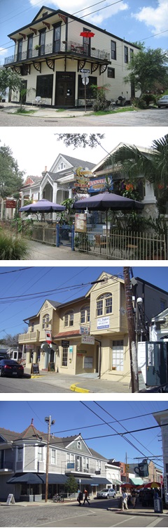 PURPOSE OF THE HISTORIC URBAN NEIGHBORHOODS
Historic Urban Neighborhoods are those areas of the city that were developed predominantly in the mid to late 19th century. The development pattern of Historic Urban Neighborhoods is characterized by a higher density and pedestrian scale environment with limited accommodation for the automobile. Within Historic Urban Neighborhoods, many of the residential neighborhoods contain traditional corner stores that serve the immediate residents and are in close proximity to commercial clusters of local businesses.
The non-residential districts of the Historic Urban Neighborhoods address the small-scale commercial areas have become integral parts of older neighborhoods. These range from pedestrian-oriented commercial clusters at the intersection of arterial streets, the traditional corner store, and mixed-use corridors. The regulations are intended to control the types of uses allowed and the scale of development to encourage their vitality while maintaining compatibility with nearby residential areas.
CHARACTER OF THE HISTORIC URBAN NEIGHBORHOODS
The character of the non-residential districts of the Historic Urban Neighborhoods is defined by:
» Commercial uses closely integrated into the residential neighborhoods, including the traditional corner store, small commercial clusters and small mixed-use corridors
» Commercial structures compatible in scale and design with the majority of buildings in nearby residential areas
» A pedestrian-oriented environment, with limited or no accommodation for on-site parking, where residents often walk to their destination
» Commercial uses generally oriented to serve the needs of nearby residents and the neighborhood
12.1 Purpose Statements
12.1.A Purpose of the HU-B1A Neighborhood Business District
The HU-B1A Neighborhood Business District is intended to address an individual parcel or small cluster of parcels in non-residential use that exist within residential areas that have historically served the neighborhood and are located on a corner, including established corner stores. These historic neighborhood business uses are consistent with the character of the surrounding neighborhood and are intended to serve the immediate area with minimal impact on the surrounding residential uses. This district also allows higher residential densities when a project is providing significant public benefits such as long-term affordable housing.
Adopted by Ord. No. 28,911, §4, January 6, 2022, Zoning Docket 84/21
12.1.B Purpose of the HU-B1 Neighborhood Business District
The HU-B1 Neighborhood Business District is intended for commercial areas that predominantly serve the needs of the nearby residential neighborhoods. The general character of this type of development should be sensitive to and compatible with its residential surroundings. In addition to commercial uses, this district provides for single-family dwellings, two-family dwellings and can accommodate small-scale multi-family dwellings. This district also allows higher residential densities when a project is providing significant public benefits such as long-term affordable housing.
Adopted by Ord. No. 28,911, §4, January 6, 2022, Zoning Docket 84/21
12.1.C Purpose of the HU-MU Neighborhood Mixed-Use District
The HU-MU Neighborhood Mixed-Use District is intended for areas of mixed-use development that are close to residential neighborhoods. The district regulations are designed to encourage mixed-use areas that are compatible with adjacent or nearby land uses and pedestrian-oriented in character. In the HU-MU District, active retail and personal service uses along the ground floor with residential uses above are encouraged. A variety of residential dwellings are also allowed. This district also allows higher residential densities when a project is providing significant public benefits such as long-term affordable housing.
Adopted by Ord. No. 28,911, §4, January 6, 2022, Zoning Docket 84/21
12.1.D Purpose of the Historic Urban Neighborhoods Non-Residential Mandatory Inclusionary Zoning Sub-Districts
The Historic Urban Neighborhoods Non-Residential Mandatory Inclusionary Zoning Sub-Districts are intended to include mandatory affordable housing requirements, in accordance with Article 28, in districts that allow the development of ten or more dwelling units.
12.2 Uses
12.2.A Permitted and Conditional Uses
Only those uses of land listed under Table 12-1: Permitted and Conditional Uses as permitted uses or conditional uses are allowed within the Historic Urban Neighborhood Districts. A “P” indicates that a use is permitted within that zoning district. A “C” indicates that a use is a conditional use in that zoning district and would require a conditional use approval as required in Section 4.3 (Conditional Use). No letter (i.e., a blank space) or the absence of the use from the table indicates that use is not permitted within that zoning district.
Table 12-1: Permitted and Conditional Uses
| Table 12-1: Permitted and Conditional Uses |
|
USE1
|
DISTRICTS
|
USE STANDARDS
|
|
HU-B1A
|
HU-B1
|
HU-MU
|
|
RESIDENTIAL USE
|
|
Bed and Breakfast – Accessory
|
C
|
C
|
C
|
Section 20.3.I
|
|
Bed and Breakfast – Principal
|
C
|
C
|
C
|
Section 20.3.I
|
|
Day Care Home, Adult – Small
|
P
|
P
|
P
|
Section 20.3.T
|
|
Day Care Home, Adult – Large
|
|
P
|
P
|
Section 20.3.T
|
|
Dwelling, Above the Ground Floor
|
P
|
P
|
P
|
|
|
Dwelling, Single-Family
|
P
|
P
|
P
|
|
|
Dwelling, Two-Family
|
P
|
P
|
P
|
Section 20.3.Y
|
|
Dwelling, Townhouse
|
|
|
P
|
Section 20.3.X
|
|
Dwelling, Multi-Family
|
|
|
P
|
|
|
Dwelling, Established Multi-Family
|
P,C8
|
P9
|
|
Section 20.3.W
|
| Dwelling, Multi-Family - Limited to 4 Units Maximum |
P |
P |
|
|
| Dwelling, Small Multi-Family Affordable |
P |
P |
P |
Section 20.3.SSS |
|
Group Home, Small
|
P
|
P
|
P
|
Section 20.3.GG
|
|
Group Home, Large
|
P2
|
P2
|
P
|
Section 20.3.GG
|
|
Group Home, Congregate
|
|
|
C
|
Section 20.3.GG
|
| Home Based Child Care, Small |
P |
P |
P |
Section 20.3.T |
| Home Based Child Care, Large |
P |
P |
P |
Section 20.3.T |
|
Permanent Supportive Housing
|
P2
|
P2
|
P
|
Section 20.3.PP
|
|
Residential Care Facility
|
P
|
P
|
P
|
Section 20.3.YY
|
|
COMMERCIAL USE
|
|
Amusement Facility, Indoor
|
|
P
|
P
|
Section 20.3.E
|
|
Animal Hospital
|
P
|
P
|
P
|
|
|
Art Gallery
|
P
|
P
|
P
|
|
|
Arts Studio
|
P
|
P
|
P
|
|
|
Bar
|
|
|
C
|
Section 20.3.G
|
| Car Wash |
|
|
C |
Section 20.3.L |
|
Catering Kitchen
|
P
|
P
|
P
|
|
| Child Care Center, Small |
P |
P |
P |
Section 20.3.S |
| Child Care Center, Large |
C |
P |
P |
Section 20.3.S |
|
Day Care Center, Adult – Small
|
P
|
P
|
P
|
Section 20.3.S
|
|
Day Care Center, Adult – Large
|
|
P
|
P
|
Section 20.3.S
|
|
Day Care Center, Adult - Commercial
|
|
P
|
P
|
Section 20.3.S
|
|
Drive-Through Facility
|
|
|
C3
|
Section 20.3.V
|
|
Financial Institution
|
P
|
P
|
P
|
|
|
Funeral Homes
|
|
C
|
C
|
|
| Grocery Store |
P |
P |
P |
|
|
Gas Station
|
|
C
|
C
|
Section 20.3.EE
|
|
Health Club
|
|
P
|
P
|
|
|
Hostel
|
|
|
C
|
|
|
Hotel/Motel
|
|
|
C
|
|
|
Live Entertainment – Secondary Use
|
|
|
C
|
Section 20.3.JJ
|
|
Medical/Dental Clinic
|
P
|
P
|
P
|
|
|
Micro-Brewery
|
|
|
P
|
|
|
Micro-Distillery
|
|
|
P
|
|
| Motor Vehicle Dealership, Small |
|
|
P |
|
| Motor Vehicle Service and Repair Facility, Small |
|
|
C |
Section 20.3.MM |
|
Office
|
P
|
P
|
P
|
|
| Outdoor Live Entertainment - Secondary Use |
|
C |
C |
Section 20.3.WWW |
|
Personal Service Establishment
|
P
|
P
|
P
|
|
|
Pet Day Care Service
|
P
|
P
|
P
|
Section 20.3.QQ
|
|
Public Market
|
|
P
|
P
|
Section 20.3.TT
|
|
Recording Studio
|
|
|
P
|
|
|
Reception Facility
|
|
C
|
C
|
Section 20.3.WW
|
|
Restaurant, Carry-Out
|
C
|
P
|
P
|
Section 20.3.ZZ
|
|
Restaurant, Fast Food
|
|
C
|
C
|
Section 20.3.ZZ
|
|
Restaurant, Specialty
|
P
|
P
|
P
|
Section 20.3.ZZ
|
|
Restaurant, Standard
|
P
|
P
|
P
|
Section 20.3.ZZ
|
|
Retail Goods Establishment
|
P
|
P
|
P
|
|
|
Retail Sales of Packaged Alcoholic Beverages
|
|
C4
|
C
|
|
| Short Term Rental, Commercial |
|
|
P |
Section 20.3.LLL |
| Small Box Variety Store |
P |
P |
P |
Section 20.3.NNN |
| Wine Shop |
|
C |
C |
Section 20.3.PPP |
| Winery |
|
|
P |
|
|
INDUSTRIAL USE
|
|
Brewery
|
|
|
P7
|
|
|
Food Processing
|
|
|
C
|
|
| Distillery |
|
|
P7 |
|
|
Manufacturing, Artisan
|
|
|
P
|
|
|
Mardi Gras Den
|
|
|
C
|
|
|
Mini-Warehouse
|
|
|
C
|
|
|
Warehouse
|
|
|
C
|
|
| INSTITUTIONAL USE |
| City Hall |
C |
C |
C |
|
|
Community Center
|
C
|
P
|
P
|
|
|
Convent and Monastery
|
|
P
|
P
|
|
|
Cultural Facility
|
C
|
C
|
C
|
Section 20.3.R
|
| Domestic Protection Shelter |
|
|
P |
Section 20.3.U |
|
Educational Facility, Primary
|
|
P
|
P
|
Section 20.3.Z
|
|
Educational Facility, Secondary
|
|
P
|
P
|
Section 20.3.Z
|
|
Educational Facility, Vocational
|
|
P
|
P
|
Section 20.3.Z
|
| Emergency Shelter |
|
|
P |
Section 20.3.AA |
|
Government Offices
|
P
|
P
|
P
|
|
|
Place of Worship
|
|
P
|
P
|
|
|
Public Works and Safety Facility
|
|
|
C
|
|
|
Social Club or Lodge
|
P
|
P
|
P
|
Section 20.3.CCC
|
|
OPEN SPACE USE
|
|
Agriculture – No Livestock
|
P
|
P
|
P
|
Section 20.3.C
|
|
Agriculture – With Livestock
|
C
|
C
|
C
|
Section 20.3.C
|
|
Parks and Playgrounds
|
P
|
P
|
P
|
|
|
Stormwater Management (Principal Use)
|
P
|
P |
P |
|
|
OTHER
|
| EV Charging Station (Principal Use) |
|
C |
C |
Section 20.3.YYY |
| Parking Lot (Accessory Use) |
P10 |
P10 |
P10 |
|
|
Parking Lot (Principal Use)
|
|
C
|
C
|
Section 20.3.OO
|
|
Parking Structure (Principal Use)
|
|
C
|
C
|
Section 20.3.OO
|
| Planned Development |
C |
C |
C |
Article 5 |
|
Utilities
|
|
P5
|
P5
|
Section 20.3.GGG
|
|
Wireless Telecommunications Antenna & Facility
|
C,P6
|
C,P6
|
C,P6
|
Section 20.3.JJJ
|
|
Wireless Telecommunications Tower & Facility
|
C
|
C
|
C
|
Section 20.3.JJJ
|
TABLE 12-1 FOOTNOTES
1 The terms in this column (“Use”) are defined in Article 26.
2 Subject to the use restrictions in Section 12.2.B.2.
3 Subject to the use restrictions in Section 12.2.B.3.
4 Subject to the use restrictions in Section 12.2.B.4.
5 Electrical Utility Substations and Transmission Lines shall be subject to design review as per Article 4, Section 4.5.B.5 and Table 4.2
6 Only wireless telecommunications antennas that comply with the stealth design standards of Section 20.3.JJJ are considered permitted uses.
7 Subject to the use restrictions in Section 12.2.B.5.
8 Established Multi-Family Dwellings that comply with Section 20.3.W.1 are permitted uses while those that comply with Section 20.3.W.2 are conditional uses.
9 Established Multi-Family Dwellings with a documented legal history are permitted uses in this district at any number previously provided.
10As authorized in Article 22, Section 22.8.B.2.a
Adopted by Jan. 20, 2017, Ord. 27,262 MCS, §1, Zoning Docket 114-16; Ord. No. 27,209, §1, Dec. 7, 2016, Zoning Docket 61/16; Ord. No. 27,375, §3, April 28, 2017, Zoning Docket 118/16; Ord. No. 27,338, §3, March 31, 2017, Zoning Docket 121/16; Ord. No. 27,726, §1, April 11, 2018, Zoning Docket 4/18; Ord. No. 27,707, §1, April 2, 2018, Zoning Docket 001/18; Technical Correction #1, 12-17-18; Ord. 28176, Sept. 5, 2019, ZD 58/19; Ord. No. 28,156 MCS, §6, August 8, 2019, Zoning Docket 026/19 & 027/19; Ord. 28349 MCS, 5-7-20, ZD 122/19; Ord. 28432 MCS, 8-6-20, ZD 38/20; Ord. 28622, 3-11-21, ZD 83/20; Ord. 28714 MCS, 7-1-21, ZD 24/24; Ord. 28696, 6-3-21, ZD 16/21; Ord 28905 MCS, 1-6-22, ZD 83/21; Ord. No. 28,911, §4, January 6, 2022, Zoning Docket 84/21; Ord 29004 MCS 4-21-22, ZD 001/22; Ord 29126, 8-12-22, ZD016/22; Ord 29157 9-15-22, ZD 030/22; Ordinance No. 29382, March 23, 2023, Zoning Docket 02/23; Ord. 29528, 7-24-23, Zoning Docket 13/23; Ordinance No. 29702, November 7, 2023, Zoning Docket 063/23
12.2.B Use Restrictions
12.2.B.1 Commercial Use Floor Area Limitation
1. Commercial Use Floor Area Limitation
In the Historic Urban Neighborhood Districts, the floor area of commercial uses is limited as follows:
a. Commercial uses are permitted uses up to five thousand (5,000) square feet of total floor area, unless conditional use approval is required per Table 12-1.
b. Conditional use approval required for any commercial use of five thousand (5,000) square feet of floor area or more with the exception of grocery stores. Grocery stores are permitted by-right up to 10,000 square feet in area.
c. Any commercial use over ten thousand (10,000) square feet of total floor area is prohibited. This applies only to new construction as of the effective date of this Ordinance. Grocery stores are exempt from this prohibition. Grocery Stores over 10,000 square feet in area require conditional use approval. Commercial uses that locate within an existing structure as of the effective date of this Ordinance that are over ten thousand (10,000) square feet of total floor area require conditional use approval.
Adopted by Ord 28805 MCS, 10-21-21, ZD 48/21
12.2.B.2 Group Home and Permanent Supportive Housing Restriction in HU-B1A and HU-B1 Districts
In the HU-B1A and HU-B1 Districts, Large Group Homes and Supportive Housing uses are only permitted when located above the ground floor.
12.2.B.3 Drive-Through Facilities in the HU-MU District
- New Drive–Through facilities in the HU-MU District are only allowed as conditional uses where they are proposed to be constructed in combination with a retail goods establishment in order to provide or dispense medical or pharmaceutical products.
- Previously constructed Drive-Through facilities may seek conditional use approval to operate, modify, expand, or reconstruct, in accordance with the standards set forth in Article 20, Section 20.3.V.
Adopted by Ord. 29850 MCS, 03-21-24, ZD 086/23;
12.2.B.4 Floor Area minimum for Retail Sales of Packaged Alcoholic Beverages in the HU-B1 District
Retail sales of alcoholic beverages in the HU-B1 Districts must be within a business with a minimum of 5,000 square feet of floor area.
12.2.B.5 Breweries in the HU-MU District
Only breweries and distilleries that produce fewer than 12,500 barrels per year are considered permitted uses in the HU-MU District.
Adopted by Ord. 28696 MCS, 6-3-21, ZD 16/21
12.3 Site Design Standards
12.3.A Bulk and Yard Regulations
12.3.A.1 General Regulations
Table 12-2: Bulk and Yard Regulations establishes bulk and yard regulations for the Historic Urban Neighborhood Districts. (Highlighted letters in Table 12-2 indicate where those bulk and yard regulations are illustrated on the accompanying site diagram.)
Table 12-2: Bulk & Yard Regulations
| Table 12-2: Bulk & Yard Regulations |
|
BULK & YARD REGULATIONS
|
DISTRICTS
|
|
HU-B1A
|
HU-B1
|
HU-MU
|
|
BULK REGULATIONS
|
|
|
MINIMUM
LOT AREA
|
SF: 1,500sf/du
2F: 1,200sf/du
MF: 1,000sf/du
MF - 3-4 Units: 1,000sf/du (maximum of 4 units)
Small MF Affordable: None
Non-Residential: None
Dwelling Above Ground Floor: 800sf/du
|
SF: 1,500sf/du
2F: 1,200sf/du
MF: 1,000sf/du
MF - 3-4 Units: 1,000sf/du (maximum of 4 units)
Small MF Affordable: None
Non-Residential: None
Dwelling Above Ground Floor: 800sf/du
|
SF: 1,500sf/du
2F: 1,200sf/du
MF: 1,000sf/du
Small MF Affordable: None
Townhouse: 2,000sf/du
Dwelling Above Ground Floor: 800sf/du
Non-Residential: None
|
|
|
MAXIMUM TOTAL
FLOOR AREA – COMMERCIAL USE1
|
Permitted up to 5,000sf of total floor area
Conditional use approval required for 5,000sf to 10,000sf of total floor area
Uses with over 10,000sf of total floor area are prohibited
|
Permitted up to 5,000sf of total floor area
Conditional use approval required for over 5,000sf of total floor area
Uses with over 10,000sf of total floor area are prohibited
|
Permitted up to 5,000sf of total floor area
Conditional use approval required for over 5,000sf of total floor area with the exception of grocery stores which are permitted by-right up to 10,000 square feet in area.
Uses with over 10,000sf of total floor area are prohibited with the exception of grocery stores which are permitted through the conditional use process over 10,000sf of total floor area and within existing structures over 10,000 square feet in area.
|
|
A
|
MINIMUM
LOT WIDTH
|
SF & 2F: 25’
Non-Residential: None
|
SF, 2F, & MF: 25’
Non-Residential: None
|
SF, 2F & MF: 25’
Townhouse: 18’ per du
Non-Residential: None
|
|
B
|
MAXIMUM
BUILDING HEIGHT
|
SF, 2F, & MF: 35’
Non-Residential: 40’ & no more than 3 stories
|
SF & 2F: 35’
Non-Residential: 40’ & no more than 3 stories
|
SF & 2F: 35’
MF, Townhouse & Non-Residential:
40’ & no more than 3 stories
|
| |
MINIMUM PERMEABLE OPEN SPACE |
10% of lot area |
10% of lot area |
10% of lot area |
|
MINIMUM YARD REQUIREMENTS
|
|
C
|
FRONT YARD
|
SF, 2F, & MF:
See Section 11.3.A.2
Non-Residential/Mixed-Use/dwelling above ground floor:
0’ build-to line
|
SF, 2F, & MF:
See Section 11.3.A.2
Non-Residential/Mixed-Use/dwelling above ground floor:
0’ to 10' build-to line
|
SF, 2F:
See Section 11.3.A.2
Non-Residential/Mixed-Use/MF:
0’ to 10' build-to line
|
|
D
|
INTERIOR
SIDE YARD
|
3’
|
SF, 2F, MF: 3’
Non-Residential/Mixed-Use/dwelling above ground floor: None, unless abutting a residential district then 3’2
|
SF & 2F: 3’
Townhouse, MF & Non-Residential/ Mixed-Use: None, unless abutting a residential district then 3’2
|
|
E
|
CORNER
SIDE YARD
|
SF, 2F, & MF:
See Section 11.3.A.3
Non-Residential/Mixed-Use/dwelling above ground floor: None, to a maximum of 3’
|
SF, 2F, & MF:
See Section 11.3.A.3
Non-Residential/Mixed-Use/dwelling above ground floor: None, to a maximum of 5’
|
SF & 2F: 10% of lot width, but a minimum of 3’
Townhouse, MF & Non-Residential/Mixed Use: None, to a maximum of 5’
|
|
F
|
REAR YARD
|
20% of lot depth or 15’, whichever is less
|
SF,2F, & MF: 20% of lot depth or 15’, whichever is less
Non-Residential/Mixed-Use/dwelling above ground floor: None, unless abutting a residential district then 15’2
|
Residential: 20% of lot depth or 15’, whichever is less
Non-Residential/Mixed-Use/MF: None, unless abutting a residential district then 15’2
|
TABLE 12-2 FOOTNOTES
1 Total floor area limits per commercial use.
2 If a property abuts more than one zoning district, the more restrictive yard requirement applies.
Table 12-3: The Mandatory Inclusionary Zoning Sub-District (MIZ) regulations establish mandatory inclusionary unit thresholds, set aside requirements, and Area Medium Income (AMI) levels and is required for any development that contains residential development of 10 or more dwelling units, including rental and homeownership dwelling units. Affordable Housing Units shall be in accordance with the standards outlined in the table below. All other bulk and yard regulations for the sub-districts are subject to the corresponding non-inclusionary zoning base district regulations.
|
Table 12-3: Historic Urban Non-Residential Inclusionary Zoning
Sub-District Regulations1
|
|
Zoning Sub-District
|
Minimum Lot Area Requirement
|
Affordable Housing Unit Threshold
|
Set Aside Requirement %
|
Area Medium Income (AMI) Rental Units (%)
|
Area Medium Income AMI Homeownership (%)
|
|
HU-B1A-IZ
|
1,000 sf/du
|
10
|
5
|
60
|
60
|
|
HU-B1-IZ
|
1,000 sf/du
|
10
|
5
|
60
|
60
|
|
HU-MU-IZ
|
1,000 sf/du
Dwelling Above Ground Floor: 800 sf/du
|
10
|
5
|
60
|
60
|
TABLE 12-3 FOOTNOTE
1The terms for the Mandatory Inclusionary Zoning Sub-Districts in this section are outlined in Article 28.

Adopted by Ord. 27,722 MCS, §5, April 11, 2018, Zoning Docket 113-17; Ord 28036, §1, March 28, 2019, ZD 112/18; Ord 28800 MCS, 10-21-21, ZD 56/21; Ord. No. 28,911, §4, January 6, 2022, Zoning Docket 84/21; Ord. 29126, 8-12-22, ZD016/22
12.3.B Building Design Standards
1. The following standards shall apply to all sites, except single and two-family residential dwellings:
a. All buildings shall provide a clearly identifiable entry from the public sidewalk at the front (primary street) elevation.
b. Structures on a corner lot shall be built to the corner.
c. Where reuse of an existing gas station is proposed, parking is permitted in the front of the structure, subject to the landscape standards of Article 23.7 provided that a designated pedestrian access way between the sidewalk and main entrance is provided. This access way shall be separated from parking areas by a landscaped area no less than five (5) feet wide.
d. The ground floor of newly constructed commercial buildings shall contain a minimum transparency of fifty percent (50%) on the primary street and windows shall be constructed of transparent glass. Opaque, highly tinted, or reflective glass is prohibited. Transparency into the building shall be maintained. Any window signs shall consist of individual letters and numerals without the use of any background.
e. For new construction, ADA accessible ramps and lifts shall compliment the building and be visually unobtrusive, preferably through internalized ramps or sloped walkways.
f. The first floor of commercial buildings shall be designed with a minimum ceiling height of twelve (12) feet.
g. Security bars, if installed, shall be on the inside of windows. Roll-up or accordion security grilles are permitted on the ground floor when constructed of a see-through, non-solid material. The Casing shall be painted to match the building and shall not damage or obscure architectural detailing.
h. The following restrictions apply to building materials:
i. The following materials are prohibited as the predominant surface finish material on exterior elevations visible from the public right-of-way. However, such materials may be used as part of decorative or detail elements, or as part of the exterior construction, such as a foundation course, that is not used as a predominant surface finish material.
(1) Exterior insulating finish systems (EIFS, “Dryvit”)
(2) Stuccato Board
(3) Vinyl
i. The siting and design requirements for buildings in the HU-MU District are illustrated in Figure 12-2: HU-MU District Illustrative and Site Diagram.
2. The following standards shall apply to all sites that meet the applicability thresholds of Section 4.5 Development Plan and Design Review:
a. Windows and doors shall have raised elements to create shadow and articulation. In addition, three-dimensional elements, such as balconies and bay windows, shall be incorporated to provide dimensional elements on a façade. Windows shall be set back into or projected out from the façade to provide façade depth and shadow and a consistent style.
b. Facades shall be designed to be viewed from multiple directions with consistent materials and treatments that wraps around all facades. There shall be a unifying architectural theme for an entire multi-family or townhouse development, utilizing a common vocabulary of architectural forms, elements, materials, and colors around the entire structure.
FIGURE 12-1: PARKING LOT LOCATION

FIGURE 12-2: HU-MU DISTRICT ILLUSTRATIVE AND SITE DIAGRAM

FIGURE 12-2: HU-MU DISTRICT ILLUSTRATIVE AND SITE DIAGRAM

Adopted by Ord. 29126, 8-12-22, ZD016/22
12.3.B.3 Townhouse and Multi-Family Dwelling Design Standards
See Section 11.3.B for building design standards for townhouse and multi-family dwellings in the Historic Urban Neighborhood Non-Residential Districts.
12.4 General Standards of Applicability
All Historic Urban Neighborhoods Districts are subject to the following standards:
12.4.A Accessory Structures and Uses
See Section 21.6 for standards governing accessory structures and uses.
12.4.B Temporary Uses
See Section 21.8 for standards governing temporary uses.
12.4.C Site Development Standards
See Article 21 for additional site development standards such as exterior lighting, environmental performance standards, and permitted encroachments.
12.4.D Off-Street Parking and Loading
See Article 22 for standards governing off-street parking and loading.
12.4.E Landscape, Stormwater Management, and Screening
See Article 23 for standards governing landscape, stormwater management, and screening.
12.4.F Signs
See Article 24 for standards governing signs.
12.4.G Overlay Districts
See Article 18 for additional overlay district regulations, when applicable.
12.4.H Nonconformities
See Article 25 for regulations governing nonconformities.
12.5 Density Bonus for Rental Properties In The Historic Urban Neighborhood Non-Residential District - HU-B1A, HU-B1, and HU-MU
Rental properties not included in the Mandatory Inclusionary Zoning sub-districts or mapped for inclusion within the Mandatory Inclusionary Zoning sub-districts, may avail themselves to the provisions provided herein.
In order to incentivize the construction of multi-family rental housing with the inclusion of affordable housing units in the Historic Urban Neighborhoods Non-Residential HU-B1A Neighborhood Business, HU-B1 Neighborhood Business, and HU-MU Neighborhood Mixed-Use Districts, density bonus and parking reductions shall be granted in exchange for the voluntary provision of affordable rental dwelling units. Developments containing ten (10) or more dwelling units that set aside at least five percent (5%) of units at a sixty percent (60%) Area Median Income level may be awarded a maximum of thirty percent (30%) reduction in the minimum lot area per dwelling unit requirements. Multi-family developments providing affordable housing units subject to the off-street parking requirements of Article 22, shall be granted a minimum of ten percent (10%) and up to a maximum of thirty percent (30%) reduction of the required parking.
Developments opting to participate in the voluntary IZ program shall be developed in accordance with Article 28, Section 28.3-Affordable Housing Development Use Standards and Guidelines and shall be subject to the regulatory and monitoring requirements outlined in Article 28, Section 28.8.
1. All applications requesting a development bonus for providing affordable housing shall include an Affordable Housing Impact Statement (AHIS) with the application. The AHIS shall provide the following information:
a. The number of units added at the Area Medium Income Levels (AMI) at or below 80%, 50%, and 30%.
b. The number of units removed at the Area Medium Income Levels at or below 80%, 50%, and 30%.
c. The bedroom mix of the unit to be added or removed (1, 2, 3, 4, etc. bedrooms).
d. The total number of units added and total number of units removed.
Adopted by Sept. 9, 2015, Zoning Docket 054-15, Ord. 26,570 MCS; Ord. 27,377 MCS, §5, April 28, 2017, Zoning Docket 007-17; Ord. 28739 MCS, 7-15-21, ZD 35/19; Ord. 29566, 8-1-23, Zoning Docket 014-23
12.6 Density Bonus For For-Sale Properties in the Historic Urban Neighborhood Non-Residential Districts
Residential properties with an affordable for-sale component may avail themselves to the provisions provided herein.
In order to incentivize the construction of for-sale housing with the inclusion of affordable dwelling units, in the Historic Urban Neighborhoods Non-Residential Districts, density bonus and parking reductions shall be granted in exchange for the voluntary provision of affordable for-sale dwelling units. Developments containing fewer than ten (10) for-sale dwelling units that set aside at least one (1) unit OR developments containing ten (10) or more for-sale dwelling units that set-aside at least ten percent (10%) of units at 120% Area Medium Income (AMI) or less shall be awarded a maximum of thirty percent (30%) reduction in the minimum lot area per dwelling unit requirements, a thirty percent (30%) reduction in required minimum lot width requirements and a thirty percent (30%) increase in the floor area ratio (FAR). Developments that meet these requirements and are subject to the off-street parking requirements of Article 22 shall be granted a fifty percent (50%) reduction of the required parking.
Developments opting to participate in the for-sale voluntary IZ program shall be developed in accordance with Article 28.
Adopted by Ord. 29566, 8-1-23, Zoning Docket 014-23
Article 13
Suburban Neighborhoods Residential Districts
PURPOSE OF THE SUBURBAN NEIGHBORHOODS
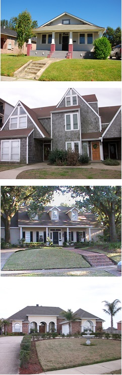 Suburban Neighborhoods developed primarily in the latter half of the 20th Century. These areas are characterized by lower density development, including neighborhoods of single-family development on lots of various sizes and more spacious setbacks between homes than found in older areas of the City with a generally uniform front setback within each square. Commercial areas within the Suburban Neighborhoods tend to be physically separated from residential areas and have few, if any, ground floor residential uses. These areas are generally located along arterial streets and typically provide accommodation for the automobile, reflecting a more suburban style of development.
The residential districts of Suburban Neighborhoods contain regulations that create and maintain living environments that preserve and reflect a form of lower density development. Within Suburban Neighborhoods, the residential districts gradually increase in density, such that the general neighborhood character is a transition from single-family through multi-family that may abut or be in closer proximity to commercial districts.
CHARACTER OF THE SUBURBAN NEIGHBORHOODS
The character of the residential districts of the Suburban Neighborhoods is defined by:
» A suburban development type, typified by housing with larger setbacks from the street and between structures, a lower density than the more urban areas of the City, and accommodation for the automobile on-site
» Neighborhoods are generally developed with a particular residential dwelling type, such as single-family dwellings
» Mid-century modern housing types, such as ranch homes and craftsman bungalows, are predominant rather than historic New Orleans architecture
13.1 Purpose Statements
13.1.A Purpose of the S-RS Single-Family Residential District
The S-RS Single-Family Residential District is intended for single-family residential neighborhoods developed after World War II where a more uniform lotting pattern is evident with larger, generally uniform setbacks. Limited non-residential uses such as places of worship that are compatible with surrounding residential neighborhoods may be allowed.
13.1.B Purpose of the S-RD Two-Family Residential District
The S-RD Two-Family Residential District is intended for use in newer areas of the City to facilitate the creation and maintenance of a more compact development type, where there may be a mix of housing types, including two-family and townhouse dwellings. This district also allows higher residential densities when a project is providing significant public benefits such a long-term affordable housing. Limited non-residential uses such as places of worship that are compatible with surrounding residential neighborhoods may be allowed.
Adopted by Ord. No. 28,911, §5, January 6, 2022, Zoning Docket 084/21
13.1.C Purpose of the S-RM1 Multi-Family Residential District
The S-RM1 Multi-Family Residential District is intended to maintain a residential environment that permits a variety of dwelling types. Population density is maintained in the medium range, and multi-family buildings up to four stories are permitted. Limited non-residential uses such as places of worship that are compatible with surrounding residential neighborhoods may be allowed.
13.1.D Purpose of the S-RM2 Multi-Family Residential District
The S-RM2 Multi-Family Residential District is intended to maintain a residential environment that permits a variety of dwelling types. Population density is maintained in the medium range, and multi-family buildings up to four stories are permitted. The district is intended for suburban multi-family areas. Limited non-residential uses such as places of worship that are compatible with surrounding residential neighborhoods may be allowed.
13.1.E Purpose of the S-LRS1 Lakeview Single-Family Residential District
The S-LRS1 Lakeview Single-Family Residential District is intended to provide for and encourage low density single-family residential development of a relatively spacious character, together with places of worship, recreational facilities, and accessory uses as may be necessary or typical for residential surroundings, in such a manner as to preserve the distinctive character of the Lakeview area. The district also is intended to provide for the maintenance of existing residential densities as well as opportunities for compatible residential growth.
13.1.F Purpose of the S-LRS2 Lake Vista and Lake Shore Single-Family Residential District
The S-LRS2 Lake Vista and Lake Shore Single-Family Residential District is intended to provide for and encourage low-density single-family residential development of a relatively spacious character consistent with the unique development pattern of the Lake Vista and Lake Shore areas together with places of worship, recreational facilities, and accessory uses as may be necessary or typical for residential surroundings.
13.1.G Purpose of the S-LRS3 Lakewood and Country Club Gardens Single-Family Residential District
The S-LRS3 Lakewood and Country Club Gardens Single-Family Residential District is intended to provide for and encourage low-density single-family residential development of a relatively spacious character in the Lakewood area, together with places of worship, recreational facilities, and accessory uses as may be necessary or typical for residential surroundings. This district is also intended to protect existing development of this character. Greater lot widths are required in the S-LRS3 District than in the S-LRS1 Lakeview Single-Family Residential District.
13.1.H Purpose of the S-LRD1 Lake Vista Two-Family Residential District
The S-LRD1 Lake Vista Two-Family Residential District is intended to provide for two-family development consistent with the historic character of development in the Lake Vista area, together with places of worship, recreational facilities, and accessory uses as may be necessary or typical for residential surroundings. This district also allows higher residential densities when a project is providing significant public benefits such as long-term affordable housing.
Adopted by Ord. No. 28,911, §5, January 6, 2022, Zoning Docket 084/21
13.1.I Purpose of the S-LRD2 Lakewood/Parkview Two-Family Residential District
The S-LRD2 Lakewood/Parkview Two-Family Residential District is intended to provide for two-family development on smaller lots of record in more densely populated sections of the Lake Area, together with places of worship, recreational facilities, and accessory uses as may be necessary or typical for residential surroundings. This district also allows higher residential densities when a project is providing significant public benefits such as long-term affordable housing.
Adopted by Ord. No. 28,911, §5, January 6, 2022, Zoning Docket 084/21
13.1.J Purpose of the S-LRM1 Lake Area Low-Rise Multi-Family Residential District
The S-LRM1 Lake Area Low-Rise Multi-Family Residential District is intended to provide for low-rise, medium density multi-family residential development in the Lake Area in proximity to single-family and two-family residential development.
13.1.K Purpose of the S-LRM2 Lake Area High-Rise Multi-Family Residential District
The S-LRM2 Lake Area High-Rise Multi-Family Residential District is intended to provide for medium to high-rise, high density multi-family residential development in proximity to single-family and two-family residential development, neighborhood business, general commercial, or marina areas.
13.2 Uses
Only those uses of land listed under Table 13-1: Permitted and Conditional Uses as permitted uses or conditional uses are allowed within the Suburban Neighborhood Districts. A “P” indicates that a use is permitted within that zoning district. A “C” indicates that a use is a conditional use in that zoning district and would require a conditional use approval as required in Section 4.3 (Conditional Use). No letter (i.e., a blank space) or the absence of the use from the table indicates that use is not permitted within that zoning district.
Table 13-1: Permitted and Conditional Uses
| Table 13-1: Permitted and Conditional Uses |
|
USE1
|
DISTRICTS
|
USE STANDARDS
|
|
S-RS
|
S-RD
|
S-RM1
|
S-RM2
|
|
RESIDENTIAL USE
|
|
Artist Community
|
|
|
P
|
P
|
Section 20.3.F
|
|
Bed and Breakfast - Accessory
|
C
|
C
|
C
|
C
|
Section 20.3.I
|
|
Day Care Home, Adult – Small
|
|
P
|
P
|
P
|
Section 20.3.T
|
|
Day Care Home, Adult – Large
|
|
|
C
|
C
|
Section 20.3.T
|
|
Dwelling, Established Two-Family
|
P
|
|
|
|
Section 20.3.W
|
|
Dwelling, Single-Family
|
P
|
P
|
P
|
P
|
|
|
Dwelling, Two-Family
|
|
P
|
P
|
P
|
Section 20.3.Y
|
|
Dwelling, Townhouse
|
|
C
|
P
|
P
|
|
|
Dwelling, Multi-Family
|
|
|
P
|
P
|
|
| Dwelling, Small Multi-Family Affordable |
|
P |
P |
P |
Section 20.3.SSS |
|
Group Home, Small
|
P
|
P
|
P
|
P
|
Section 20.3.GG
|
|
Group Home, Large
|
|
|
P
|
P
|
Section 20.3.GG
|
|
Group Home, Congregate
|
|
|
C
|
C
|
Section 20.3.GG
|
| Home Based Child Care Center, Small |
P |
P |
P |
P |
Section 20.3.T |
| Home Based Child Care Center, Large |
C |
C |
C |
C |
Section 20.3.T |
|
Permanent Supportive Housing
|
|
|
P
|
P
|
Section 20.3.PP
|
|
Residential Care Facility
|
|
P
|
P
|
P
|
Section 20.3.YY
|
| COMMERCIAL USE |
|
|
|
|
|
| Child Care Center, Small |
C |
C |
P |
P |
Section 20.3.S |
| Child Care Center, Large |
C |
C |
C |
P |
Section 20.3.S |
|
INDUSTRIAL USE
|
|
Borrow Pit
|
C
|
C
|
C
|
C
|
Section 20.3.J
|
|
Solar Energy System – Small-Scale Ground Mounted Only
|
P
|
P
|
P
|
P
|
Section 20.3.DDD
|
|
INSTITUTIONAL USE
|
| City Hall |
C |
C |
C |
C |
|
|
Community Center
|
C
|
C
|
C
|
C
|
|
|
Convent and Monastery
|
P
|
P
|
P
|
P
|
|
|
Cultural Facility
|
C
|
C
|
C
|
C
|
Section 20.3.R
|
| Domestic Protection Shelter |
|
|
P |
P |
Section 20.3.U |
|
Educational Facility, Primary
|
C
|
C
|
C
|
C
|
Section 20.3.Z
|
|
Educational Facility, Secondary
|
C
|
C
|
C
|
C
|
Section 20.3.Z
|
| Emergency Shelter |
|
|
P |
P |
Section 20.3.AA |
|
Government Offices
|
P
|
P
|
P
|
P
|
|
|
Hospital
|
|
|
C
|
C
|
|
|
Place of Worship
|
P
|
P
|
P
|
P
|
|
|
Public Works and Safety Facilities
|
C
|
C
|
C
|
C
|
|
|
Social Club or Lodge
|
C
|
C
|
C
|
C
|
Section 20.3.CCC
|
| Veterans Wellness Facility |
|
|
C |
C |
Section 20.3.OOO |
|
OPEN SPACE USE
|
|
Agriculture – No Livestock
|
P
|
P
|
P
|
P
|
Section 20.3.C
|
|
Agriculture – With Livestock
|
C
|
C
|
C
|
C
|
Section 20.3.C
|
|
Horse Stables (Commercial)
|
C
|
|
|
|
Section 20.3.HH
|
|
Parks and Playgrounds
|
P
|
P
|
P
|
P
|
|
|
Private Residential Recreation Facility (Indoor or Outdoor)
|
P
|
P
|
P
|
P
|
Section 20.3.SS
|
|
Stormwater Management (Principal Use)
|
P
|
P |
P |
P |
|
|
OTHER
|
| Parking Lot (Accessory Use) |
C5 |
C5 |
C5 |
C5 |
|
| Planned Development |
C |
C |
C |
C |
Article 5 |
|
Pumping Station
|
P
|
P
|
P
|
P
|
Section 20.3.UU
|
|
Utilities
|
P2
|
P2
|
P2
|
P2
|
Section 20.3.GGG
|
|
Wireless Telecommunications Antenna & Facility
|
C,P3
|
C,P3
|
C,P3
|
C,P3
|
Section 20.3.JJJ
|
|
Wireless Telecommunications Tower & Facility
|
C
|
C
|
C
|
C
|
Section 20.3.JJJ
|
Table 13-1: Permitted and Conditional Uses
| Table 13-1: Permitted and Conditional Uses |
|
USE1
|
DISTRICTS
|
USE STANDARDS
|
|
S-LRS1
|
S-LRS2
|
S-LRS3
|
S-LRD1
|
S-LRD2
|
S-LRM1
|
S-LRM2
|
|
RESIDENTIAL USE
|
|
Bed and Breakfast - Accessory
|
C
|
|
|
|
C
|
C
|
C
|
Section 20.3.I
|
|
Day Care Home, Adult – Small
|
P
|
P
|
P
|
P
|
P
|
P
|
P
|
Section 20.3.T
|
|
Day Care Home, Adult - Large
|
|
|
|
|
|
C
|
C
|
Section 20.3.T
|
|
Dwelling, Established Two-Family
|
P,C4
|
|
|
|
|
|
|
Section 20.3.W
|
|
Dwelling, Established Multi-Family
|
P,C4
|
|
|
|
|
|
|
Section 20.3.W
|
|
Dwelling, Single-Family
|
P
|
P
|
P
|
P
|
P
|
P
|
P
|
|
|
Dwelling, Two-Family
|
|
|
|
P
|
P
|
P
|
P
|
|
|
Dwelling, Townhouse
|
|
|
|
|
C
|
P
|
P
|
|
|
Dwelling, Multi-Family
|
|
|
|
|
|
P
|
P
|
|
| Dwelling, Small Multi-Family Affordable |
|
|
|
P |
P |
P |
P |
Section 20.3.SSS |
|
Group Home, Small
|
P
|
P
|
P
|
P
|
P
|
P
|
P
|
Section 20.3.GG
|
|
Group Home, Large
|
|
|
|
|
|
P
|
P
|
Section 20.3.GG
|
|
Group Home, Congregate
|
|
|
|
|
|
C
|
C
|
Section 20.3.GG
|
| Home Based Child Care, Small |
P |
P |
P |
P |
P |
P |
P |
Section 20.3.T |
| Home Based Child Care, Large |
C |
C |
C |
C |
C |
P |
P |
Section 20.3.T |
|
Permanent Supportive Housing
|
|
|
|
|
|
P
|
P
|
Section 20.3.PP
|
|
Residential Care Facility
|
|
|
|
P
|
P
|
P
|
P
|
Section 20.3.YY
|
|
COMMERCIAL USE
|
| Child Care Center, Small |
|
C |
C |
C |
C |
P |
P |
Section 20.3.S |
| Child Care Center, Large |
|
|
|
|
|
C |
P |
Section 20.3.S |
|
Day Care Center, Adult - Small
|
|
C
|
C
|
C
|
C
|
P
|
P
|
Section 20.3.S
|
|
Day Care Center, Adult – Large
|
|
|
|
|
|
C
|
C
|
Section 20.3.S
|
|
INSTITUTIONAL USE
|
|
Community Center
|
C
|
C
|
C
|
C
|
C
|
C
|
C
|
|
|
Convent and Monastery
|
P
|
P
|
P
|
P
|
P
|
P
|
P
|
|
|
Cultural Facility
|
C
|
C
|
C
|
C
|
C
|
C
|
C
|
Section 20.3.R
|
|
Educational Facility, Primary
|
C
|
C
|
C
|
C
|
C
|
C
|
C
|
Section 20.3.Z
|
|
Educational Facility, Secondary
|
C
|
C
|
C
|
C
|
C
|
C
|
C
|
Section 20.3.Z
|
|
Educational Facility, Vocational
|
C
|
|
|
|
|
C
|
C
|
Section 20.3.Z
|
|
Government Offices
|
P
|
P
|
P
|
P
|
P
|
P
|
P
|
|
|
Hospital
|
|
|
|
|
|
C
|
C
|
|
|
Place of Worship
|
P
|
P
|
P
|
P
|
P
|
P
|
P
|
|
|
Public Works and Safety Facility
|
C
|
C
|
C
|
C
|
C
|
C
|
C
|
|
|
Social Club or Lodge
|
C
|
C
|
C
|
C
|
C
|
C
|
C
|
Section 20.3.CCC
|
|
OPEN SPACE USE
|
|
Agriculture – No Livestock
|
P
|
P
|
P
|
P
|
P
|
P
|
P
|
Section 20.3.C
|
|
Agriculture – With Livestock
|
C
|
C
|
C
|
C
|
C
|
C
|
C
|
Section 20.3.C
|
|
Parks and Playgrounds
|
P
|
P
|
P
|
P
|
P
|
P
|
P
|
|
|
Private Residential Recreation Facility (Indoor or Outdoor)
|
C
|
C
|
C
|
C
|
C
|
C
|
C
|
Section 20.3SS
|
|
Stormwater Management (Principal Use)
|
P
|
P |
P |
P |
P |
P |
P |
|
|
OTHER
|
| Parking Lot (Accessory Use) |
C5 |
C5 |
C5 |
C5 |
C5 |
C5 |
C5 |
|
| Planned Development |
C |
C |
C |
C |
C |
C |
C |
Article 5 |
|
Pumping Station
|
P
|
P
|
P
|
P
|
P
|
P
|
P
|
Section 20.3.UU
|
|
Utilities
|
P2
|
P2
|
P2
|
P2
|
P2
|
P2
|
P2
|
Section 20.3.GGG
|
|
Wireless Telecommunications Antenna & Facility
|
C,P3
|
C,P3
|
C,P3
|
C,P3
|
C,P3
|
C,P3
|
C,P3
|
Section 20.3.JJJ
|
|
Wireless Telecommunications Tower and Facility
|
C
|
C
|
C
|
C
|
C
|
C
|
C
|
Section 20.3.JJJ
|
TABLE 13-1 FOOTNOTES
1 The terms in this column (“Use”) are defined in Article 26.
2 Electrical Utility Substations and Transmission Lines shall be subject to design review as per Article 4, Section 4.5B.5 and Table 4-2
3 Only wireless telecommunications antennas that comply with the stealth design standards of Section 20.3.JJJ are considered permitted uses.
4 Established Multi-Family Dwellings that comply with Section 20.3.W.1 are permitted uses while those that comply with Section 20.3.W.2 are conditional uses.
5As authorized in Article 22, Section 22.8.B.2.a
Adopted by Ord. No. 27,209, §1, Dec. 7, 2016, Zoning Docket 61/16; Ord. No. 27,375, §4, April 28, 2017, Zoning Docket 118/16; Ord. No. 27,707, §1, April 2, 2018, Zoning Docket 001/18; Ord. 28036 MCS, §1, March 28, 2019, ZD 112/18; Ord. 28176, Sept. 5, 2019, ZD 59/19; Ord. No. 28,156 MCS, §7, August 8, 2019, Zoning Docket 026/19 & 027/19; Ord.28328 MCS, 4-15-20, ZD 115/19; Ord. 28432 MCS, 8-6-20, ZD 38/20; Ord. 28622, 3-11-21, ZD 83/20; Ord. 28739 MCS, ZD 35/21; Ord. 28783 MCS, 9-23-21, ZD 45/21; Ord 28905 MCS, 1-6-22, ZD 83/21; Ord. No. 28,911, §5, January 6, 2022, Zoning Docket 084/21; Ord. 29126, 8-12-22, ZD016/22; Ordinance No. 29382, March 23, 2023, Zoning Docket 02/23; Ordinance No. 29702, November 7, 2023, Zoning Docket 063/23; Ord. No 29744, 12-8-23, Zoning Docket 055/23
13.3 Site Design Standards
13.3.A Bulk and Yard Regulations
13.3.A.1 General Regulations
Table 13-2: Bulk and Yard Regulations establishes bulk and yard regulations for the Suburban Neighborhood Districts. (Highlighted letters in Table 13-2 indicate where those bulk and yard regulations are illustrated on the accompanying site diagram.)
Table 13-2: Bulk & Yard Regulations
| Table 13-2: Bulk & Yard Regulations |
|
BULK & YARD REGULATIONS
|
DISTRICTS
|
|
S-RS
|
S-RD
|
|
BULK REGULATIONS
|
|
|
MINIMUM LOT AREA
|
6,000sf/du
Non-Residential: 20,000sf
|
SF: 4,400sf/du
2F: 2, 500sf/du
Small MF Affordable: None
Townhouse: 2,000sf/du
Non-Residential: 20,000sf/du
|
|
A
|
MINIMUM LOT WIDTH
|
Residential: 50’
Non-Residential: 100’
|
SF: 40’
2F: 50’
MF: 50'
Townhouse: 18’ per du
Non-Residential: 100’
|
|
B
|
MINIMUM LOT DEPTH
|
100’
|
Residential: 90’
Non-Residential: 100’
|
|
C
|
MAXIMUM BUILDING HEIGHT
|
35’
|
35’
|
| |
MINIMUM PERMEABLE OPEN SPACE |
40% of lot area |
40% of lot area |
| |
MINIMUM OPEN SPACE |
|
Townhouse: 120sf/du |
|
|
MAXIMUM IMPERVIOUS SURFACE - FRONT YARD
|
40%
|
40%
|
| |
MAXIMUM IMPERVIOUS SURFACE - CORNER SIDE YARD |
40% |
40% |
|
|
MAXIMUM NUMBER OF ATTACHED TOWNHOUSE UNITS
|
|
6
|
|
MINIMUM YARD REQUIREMENTS
|
|
D
|
FRONT YARD
|
20’
|
20’
|
|
E
|
INTERIOR SIDE YARD
|
10% of lot width or 3’, whichever is greater
|
SF, 2F, & MF: 10% of lot width, but a minimum of 3’
Townhouse: 10’; unless adjacent to a single-family residential district, then 15’
Non-Residential: 10’
|
|
F
|
CORNER SIDE YARD
|
10’
|
SF,2F, & MF: 10% of lot width, but a minimum of 3’
Townhouse & Non-Residential: 10’
|
|
G
|
REAR YARD
|
20% of lot depth or 20’, whichever is less
|
20% of lot depth or 20’, whichever is less
|
Table 13-2: Bulk & Yard Regulations
| Table 13-2: Bulk & Yard Regulations |
|
BULK & YARD REGULATIONS
|
DISTRICTS
|
|
S-LRS1
|
S-LRS2
|
S-LRS3
|
S-LRD1
|
S-LRD2
|
|
BULK REGULATIONS
|
|
|
MINIMUM LOT AREA
|
SF: 4,800sf/du
2F: 2,500sf/du
Non-Residential: 20,000sf
|
Residential: 6,700sf/du
Non-Residential: 20,000sf
|
Lakewood South and the West Side of Bellaire Drive in Lakewood North: the Pontchartrain Expressway, Railroad tracks, Orleans- Jefferson Parish line, Veterans Highway, Bellaire Drive Country Club Gardens and Lakewood North except that portion west of Bellaire Drive
Lakewood North portion: Bellaire Drive, Veterans Highway, Fleur de Lis Drive, and Interstate 10
Residential: 6,700sf/du
Non-Residential: 20,000sf
Country Club Gardens and Lakewood North except that portion West of Bellaire Drive: Orleans-Jefferson Parish line, Railroad tracks, Pontchartrain Expressway, the southern boundary of the S-LRS3 District, and Palmetto Street
Residential: 5,000sf/du
Non-Residential: 20,000sf
|
SF: 5,000sf/du
2F: 3,250sf/du
Small MF Affordable: None
Non-Residential: 20,000sf
|
SF: 4,400sf/du
2F: 2,500sf/du
Small MF Affordable: None
Non-Residential: 20,000sf
|
|
A
|
MINIMUM LOT WIDTH
|
SF: 40’
2F: 50’
Non-Residential: 100’
|
Residential: 60’
Non-Residential: 100’
|
Lakewood South and the West Side of Bellaire Drive in Lakewood North: the Pontchartrain Expressway, Railroad tracks, Orleans- Jefferson Parish line, Veterans Highway, Bellaire Drive Country Club Gardens and Lakewood North except that portion west of Bellaire Drive
Lakewood North portion: Bellaire Drive, Veterans Highway, Fleur de Lis Drive, and Interstate 10
Residential: 60’
Non-Residential: 100’
Country Club Gardens and Lakewood North except that portion West of Bellaire Drive: Orleans-Jefferson Parish line, Railroad tracks, Pontchartrain Expressway, the southern boundary of the S-LRS3 District, and Palmetto Street
Residential: 50’
Non-Residential: 100’
|
SF: 50’
2F: 60’
MF: 60'
Non-Residential: 100’
|
SF: 40’
2F: 50’
MF:50'
Non-Residential: 100’
|
|
B
|
MINIMUM LOT DEPTH
|
SF & 2F: 90’
Non-Residential: 100’
|
100’
|
Lakewood South and the West Side of Bellaire Drive in Lakewood North: the Pontchartrain Expressway, Railroad tracks, Orleans- Jefferson Parish line, Veterans Highway, Bellaire Drive Country Club Gardens and Lakewood North except that portion west of Bellaire Drive
Lakewood North portion: Bellaire Drive, Veterans Highway, Fleur de Lis Drive, and Interstate 10
100’
Country Club Gardens and Lakewood North except that portion West of Bellaire Drive: Orleans-Jefferson Parish line, Railroad tracks, Pontchartrain Expressway, the southern boundary of the S-LRS3 District, and Palmetto Street
Residential: 90’
Non-Residential: 100’
|
Residential: 90’
Non-Residential: 100’
|
Residential: 90’
Non-Residential: 100’
|
|
C
|
MAXIMUM BUILDING HEIGHT
|
40’ & no more than 3 stories
|
35’ & no more than 3 stories
|
35’ & no more than 3 stories
|
35’ & no more than 3 stories
|
35’ & no more than 3 stories
|
| |
MINIMUM PERMEABLE OPEN SPACE |
40% of lot area |
40% of lot area |
40% of lot area |
40% of lot area |
40% of lot area |
| |
MINIMUM OPEN SPACE |
None |
None |
None |
None |
Townhouse: 120sf/du |
| |
MAXIMUM IMPERVIOUS SURFACE - FRONT YARD |
40% |
40% |
40% |
40% |
40% |
| |
MAXIMUM IMPERVIOUS SURFACE - CORNERSIDE YARD |
40% |
40% |
40% |
40% |
40% |
|
|
MAXIMUM NUMBER OF ATTACHED TOWNHOUSE UNITS
|
|
|
|
|
6
|
|
MINIMUM YARD REQUIREMENTS
|
|
D
|
FRONT YARD
|
20’
|
20’
|
20’
|
20’
|
20’
|
|
E
|
INTERIOR SIDE YARD
|
4’
|
Residential: 6’
Non-Residential: 10’
|
Residential: 3’
Non-Residential: 10’
|
Residential: 6’
Non-Residential: 10’
|
Residential: 3’
Non-Residential: 10’
|
|
F
|
CORNER SIDE YARD
|
10’
|
10’
|
10’
|
10’
|
10’
|
|
|
MINIMUM REQUIRED AGGREGATE OF SIDE YARDS (PERCENT OF LOT WIDTH)
|
20% to a maximum required aggregate of 10’
|
Residential: 20% to a maximum required aggregate of 10’
Non-Residential: 25% to a maximum required aggregate of 20’
|
Residential: 20% to a maximum required aggregate of 10’
Non-Residential: 25% to a maximum required aggregate of 20’
|
Residential: 20% to a maximum required aggregate of 10’
Non-Residential: 25% to a maximum required aggregate of 20’
|
Residential: 20% to a maximum required aggregate of 10’
Non-Residential: 25% to a maximum required aggregate of 20’
|
|
G
|
REAR YARD
|
20’
|
Residential: 16% of lot depth or 15’, whichever is greater, to a maximum of 20’
Non-Residential: 20’
|
20’
|
Residential: 15’
Non-Residential: 20’
|
20’
|
Table 13-2: Bulk & Yard Regulations
| Table 13-2: Bulk & Yard Regulations |
|
BULK & YARD REGULATIONS
|
DISTRICTS
|
|
S-RM1
|
S-RM2
|
S-LRM1
|
S-LRM2
|
|
BULK REGULATIONS
|
|
|
MINIMUM LOT AREA
|
SF: 3,125sf/du
2F: 1,750sf/du
Small MF Affordable: None
MF – 3 Unit: 1,500sf/du
MF – 4+ Unit: 1,250sf/du
Townhouse: 2,000sf/du
Non-Residential: 20,000sf
|
SF: 3,125sf/du
2F: 1,750sf/du
Small MF Affordable: None
MF-3 Unit: 1,500sf/du
MF – 4 Unit: 1,200sf/du
MF – 5+ Unit: 2,722sf/du
Townhouse: 2,000sf/du
Non-Residential: 20,000sf
|
SF: 3,125sf/du
2F: 1,750sf/du
MF – 3 Unit: 1,500sf/du
MF – 4 Unit: 1,200sf/du
Small MF Affordable: None
MF – 5+ Unit: 1,000sf/du
Townhouse: 2,000sf/du
Non-Residential: 20,000sf
|
SF: 3,125sf/du
2F: 1,750sf/du
MF – 3 Unit: 1,200sf/du
MF – 4 Unit: 1,000sf/du
Small MF Affordable: None
MF – 5-11 Unit: 1,000sf/du
MF – 12-40 Unit: 1,000sf/du
MF – 41+ Unit: 1,000sf/du
Townhouse: 2,000sf/du
Non-Residential: 20,000sf
Educational Facility: 2 ac
|
|
A
|
MINIMUM LOT WIDTH
|
SF & 2F: 30’
MF – 3 Unit: 40’
MF – 4+ Unit: 50’
Townhouse: 18’ per du
Non-Residential: 100’
|
SF & 2F: 30’
MF – 3 Unit: 40’
MF – 4+ Unit: 50’
Townhouse: 20’ per du & 80’ per development
Non-Residential: 100’
|
SF & 2F: 30’
MF – 3 Unit: 40’
MF – 4+ Unit: 50’
Townhouse: 18’ per du
Non-Residential: 100’
|
SF & 2F: 30’
MF – 3 or 4 Unit: 40’
MF – 5-11 Unit: 50’
MF – 12-16 Unit: 60’
MF – 17-40 Unit: 75’
MF – 41+ Unit: 100’
Townhouse: 18’ per du
Non-Residential: 100’
Educational Facility: 30’
|
|
B
|
MINIMUM LOT DEPTH
|
Residential: 90’
Non-Residential: 100’
|
SF, 2F & MF – 3-4 Unit: 90’
MF – 5+ Unit: 130’
Townhouse: 100’ per development
Non-Residential: 100’
|
Residential: 90’
Non-Residential: 100’
|
SF, 2F, MF – 3 to 11 Units, Townhouse & Non-Residential: 90’
MF – 12+ Units & Educational Facility: 100’
|
|
|
MAXIMUM NUMBER OF MF DWELLING UNITS PER BUILDING
|
|
40
|
|
|
|
|
MAXIMUM NUMBER OF ATTACHED TOWNHOUSE UNITS
|
6
|
6
|
6
|
6
|
|
C
|
MAXIMUM BUILDING HEIGHT
|
SF, 2F, MF – 3-4 Unit, Townhouse & Non-Residential: 40’
MF – 5+ Unit: 45’’
|
SF & 2F: 35’
MF – 3-4 Unit & Non-Residential: 45’
Townhouse: 45’ & no more than 3.5 stories
MF – 5+ Unit: 45’ & no more than 4 stories
|
SF, 2F, MF – 3-4 Unit, Townhouse & Non-Residential: 40’
MF – 5+ Unit: 55’
|
SF, 2F, Townhouse & Non-Residential: 40’
Multi-Family: 90’
|
|
|
MINIMUM HEIGHT OF TOWNHOUSE & MF FIRST RESIDENTIAL FLOOR ABOVE GRADE
|
|
8’
|
|
|
| |
MINIMUM PERMEEABLE OPEN SPACE |
40% of lot area |
40% of lot area |
40% of lot area |
40% of lot area |
| |
MINIMUM OPEN SPACE RATIO |
None |
None |
None |
None |
|
|
MINIMUM SPACE BETWEEN MF BUILDINGS
|
Building Side to Building Side: 20’ when no curb cut access & 40’ with curb cut access
Building Side to Building Rear: 40’
Building Rear to Building Rear: 60’
|
Building Side to Building Side: 20’ when no curb cut access & 40’ with curb cut access
Building Side to Building Rear: 40’
Building Rear to Building Rear: 60’
|
|
|
|
|
MAXIMUM SPACE BETWEEN MF BUILDINGS
|
|
Townhouse: 30’
MF – 5+ Unit: 40’
|
|
|
|
|
MAXIMUM BUILDING LENGTH
|
|
Townhouse & MF: 180’
|
|
|
|
|
MINIMUM MF UNIT SIZE
|
|
1 BR: 500sf
2 BR: 700sf
3 BR: 900sf
4+ BR: 1,200sf
|
|
|
|
YARD REQUIREMENTS
|
|
D
|
MINIMUM FRONT YARD
|
20’
|
20’
Townhouse & MF: 20’ build-to line
|
20’
|
20’
|
|
E
|
MINIMUM INTERIOR SIDE YARD
|
SF, 2F, Townhouse & MF – 3 to 4 Unit: 10% of lot width, but a minimum of 3’
MF – 5+ Unit: 5’
Non-Residential: 10’
|
SF, 2F & MF – 3-4 Unit: 10% of lot width, but a minimum of 3’
Townhouse, MF – 5+ Unit & Non-Residential:
Minimum - 10’
Maximum –
When building is adjacent to property line: 15’
When curb cut is provided between building & property line: 40’
|
SF, 2F & MF – 3 to 4 Unit: 3’
MF – 5+ Unit & Townhouse: 5’
Non-Residential: 10’
|
SF, 2F & MF – 3 to 4 Unit: 3’
MF – 5-16 Unit & Townhouse: 5’
MF – 17+ Unit: 6’
Educational Institutions: 20’
Non-Residential: 10’
|
|
F
|
MINIMUM CORNER SIDE YARD
|
10’
|
SF, 2F, MF – 3-4 Unit & Non-Residential: 10’
Townhouse & MF: 20’ build-to line
|
10’
|
10’
|
|
|
MINIMUM REQUIRED AGGREGATE OF SIDE YARDS (PERCENT OF LOT WIDTH)
|
|
|
SF, 2F, MF – 3-5 Unit: 20% to a maximum required aggregate of 10’
Townhouse: 20% to a maximum required aggregate of 15’
Non-Residential: 20% to a maximum required aggregate of 20’
|
SF, 2F, MF 3-16 Unit & Townhouse: 20% to a maximum required aggregate of 10’
MF - 17-40 Unit: 20% to a maximum required aggregate of 15’
MF – 41+ Unit: 20% to a maximum required aggregate of 12’
Non-Residential: 20% to a maximum required aggregate of 20’
Educational Institutions: 30% to a maximum required aggregate of 40’
|
|
G
|
MINIMUM REAR YARD
|
20’
|
SF & 2F: 15’
MF – 3-4 Unit & Non-Residential: 20’
Townhouse & MF – 5+ Unit: 30’
|
20’
|
SF, 2F & MF - 3-11 Unit: 15’
MF – 12+ Unit, Townhouse, Educational Institution & Non-Residential: 20’
|


Adopted by Ord. No. 26,726, §1, December 7, 2015, Zoning Docket 081/15; Ord. No. 27,722, §6, April 11, 2018, Zoning Docket 113/17; Ord. No. 28,911, §5, January 6, 2022, Zoning Docket 084/21; Ord. 29126, 8-12-22, ZD016/22
13.3.A.2 Lake Vista Yard Definition
In the Lake Vista area of the S-LRS2 and S-LRD1 Districts, the front and rear yard requirements of through lots are assigned as follows: the front yard requirements apply to that yard which faces lanes and parks, and the rear yard requirements apply to that yard which faces the public street. (See Figure 13-1: Lake Vista Yard Location)
FIGURE 13-1: LAKE VISTA YARD LOCATION

13.3.A.3 Required On-Site Open Space
All townhouse and multi-family dwellings shall provide at least one-hundred twenty (120) square feet of useable on-site open space per dwelling unit. This open space may be either private open space for the dwelling unit or common open space restricted to the use of residents of the townhouse or multi-family dwelling. Such open space shall meet the following requirements:
a. Required open space shall have a minimum dimension of at least seven (7) feet on any side.
b. Required open space shall be located on the same lot as the dwelling unit it serves.
c. Required open space shall be outdoors and designed for outdoor living, recreation, or landscape, including areas located on the ground and areas on decks, balconies, galleries, porches, or roofs. For multi-family dwellings, when open space is above grade, such as a balcony or gallery, it may not be located over on-site surface parking areas.
d. The required open space area may not be contiguous, but each open space area, whether common or private, shall comply with minimum dimensional standards of Table 13-2. Common open space areas shall be accessible to all residents of the subject development.
e. When located at ground level, the required open space area shall be substantially covered with grass, live groundcover, shrubs, plants, trees, or permeable outdoor hardscape features or amenities, such as seating areas, patios, or pools.
f. Off-street parking and loading areas, driveways or required landscape for parking lots and screening do not satisfy open space requirements. Bollards, curbs, wheel stops, or other similar features shall be provided to ensure that required open space areas are not used for off-street parking or any other vehicular use.
g. Mechanical equipment, dumpsters, or service areas are prohibited in required open space areas.
h. All required open space areas shall be located and designed to take advantage of sunlight and other climatic advantages of the site.
Adopted by Ord. No. 27,722, §6, April 11, 2018, Zoning Docket 113/17;
13.3.B Building Design Standards
1. The following standards shall apply to all single- and two-family dwellings:
a. All buildings shall provide a clearly articulated entry from the public sidewalk at the front elevation.
b. In the S-LRS1 Lakeview Single-Family Residential District, all single- and two-family dwellings having rear alley access shall be prohibited from having front facing garages, carports, and/or parking areas, and curb cuts in or to a front yard. All single- and two-family residences having no rear-alley access shall be permitted to have garages and or parking areas, but such front facing garages or parking areas, whether or not they are connected to the main structure, must be located at least five (5) feet behind the front façade of the principal building.
c. Front-loaded attached garages shall not occupy more than twenty-two (22) feet in garage door width or fifty percent (50%) of the width of the front façade of the house, as measured along the building line that faces the street, whichever is greater.
d. Roll down shutters and hardware shall not be visible from a public right-of-way when not in use.
2. The following building design standards apply to townhouse and multi-family developments in the residential districts of the Suburban Neighborhoods.
a. All buildings shall be oriented towards the public or private street in terms of architectural interest and materials and building access.
b. All buildings shall provide a clearly articulated entry from the public sidewalk at the front elevation.
c. Driveways should be configured to minimize the reduction of on-street parking spaces.
d. The site shall be designed with safe pedestrian access to the development from the street and from any parking areas, as well as internal to the site.
e. Safe pedestrian access from adjacent properties is required. Sidewalks shall extend to the lot line and connect to existing sidewalks on abutting property if feasible.
f. Plain mansard roofs are prohibited. Decorative mansard roofs are permitted on buildings with a minimum wall height of two (2) stories. (See Figure 15-2: Examples of Decorative Mansard Roofs.)
g. To avoid the appearance of blank walls facing the street, when the side walls of a dwelling face a street, building facades shall be designed with multiple windows of a size matching those on the front elevation.
h. Parking Areas and Pedestrian Walkways
i. Parking is prohibited between the street line and the front building line. The front building line does not include any architectural features of the front façade. On a corner lot, parking is prohibited within the corner side yard within five (5) feet of the front lot line.
ii. Driveways should be consolidated, where possible, in order to reduce curb cuts. Adjacent residential buildings should, where possible, share driveway access.
iii. The site shall be designed with safe pedestrian access to the development from the street and from any parking areas, as well as internal to the site.
iv. Safe pedestrian access from adjacent properties is required. Sidewalks shall extend to the lot line and connect to existing sidewalks on abutting property if feasible.
v. Mid-building pedestrian passages shall be provided through buildings with a width of greater than two-hundred and fifty (250) feet. Such passageways shall be designed to be safe and well-lit, providing convenient pedestrian access to and from areas such as parking lots and structures, and/or service streets from the opposite sides of a building. The passage shall be a minimum of eight (8) feet in width.
vi. Driveways and curb cuts shall include clearly marked crosswalks where they intersect with the pedestrian circulation system.
vii. Any provided bicycle circulation infrastructure such as dedicated lanes and cycle tracks shall extend to the lot lines.
i. Building Materials
i. The following materials are prohibited as the predominant surface finish material in the construction of new multi-family and townhouse developments. However, such materials may be used as part of decorative or detail elements, or as part of the exterior construction, such as a foundation course, that is not used as a predominant surface finish material.
(1) Exterior insulation finish systems (EIFS) (e.g.“Dryvit”)
(2) Stuccato board
(3) Vinyl
3. The following standards shall apply to all sites that meet the applicability thresholds of Section 4.5 Development Plan and Design Review:
a. Large, flat facades facing the street shall be avoided. Form-giving elements such as, but not limited to, galleries, balconies, projected entrances, and overhangs are required on the street-facing façade.
b. To ensure that new developments are compatible with the surrounding neighborhood character, consistency in the roofline shall be achieved by using similar roof types, slope, materials and details.
c. Windows and doors shall have raised elements to create shadow and articulation. In addition, three-dimensional elements, such as balconies and bay windows, shall be incorporated to provide dimensional elements on a façade. Windows shall be set back into or projected out from the façade to provide façade depth and shadow and a consistent style.
d. Facades shall be designed to be viewed from multiple directions and with consistent materials that wraps around all facades. There shall be a unifying architectural theme for an entire multi-family or townhouse development, utilizing a common vocabulary of architectural forms, elements, materials, and colors around the entire structure.
e. Unless typical of existing development within the neighborhood, large, monotonous, simple pitched roofs, without breaks in the expanse of the roof, are prohibited. Properly proportioned dormers and gables shall be used to break up large expanses of roof area.
13.3.B.4 Additional Design Standards for S-RM2 District
In addition to the design standards of Paragraph 2 above, townhouse and multi-family dwellings in the S-RM2 District shall comply with the following additional design standards.
13.3.B.4.a Ground Floor of Multi-Family Dwellings
i Portions of the non-habitable ground floor façade not used for building access or fenestration shall be designed according to the following requirements:
(1) For multi-family buildings that use the ground floor for common tenant facilities (such as a fitness room, laundry facility, or meeting space), foundation landscape and/or grading shall be used to screen the portion of the wall between the existing grade and a line three (3) feet above the existing grade. (See Figure 13-2: Multi-Family Ground Floor) On the portion of the ground floor façade above this line, windows shall be provided that create an appropriate level of transparency and reflect the character of the upper floor façade design. Landscape may be omitted directly in front of windows or doors in order to provide adequate interior light and access.
FIGURE 13-2: MULTI-FAMILY GROUND FLOOR

(2) For multi-family buildings that do not use the ground floor for common resident facilities, or if it is used for utility spaces such as vehicular parking, storage, or building infrastructure, foundation grading shall be provided such that the grading meets the building façade at a point four (4) feet above the existing grade.
13.3.B.4.b Ground Floor of Townhouse Dwellings
For townhouses, the entire portion of the ground floor façade between the existing grade and a line four (4) feet above the existing grade shall be screened. Screening techniques may include grading and landscape, or stairs and hardscape that provide access to the first habitable floor, or a combination of both. However, no flight of stairs may account for more than four (4) feet in elevation change without providing a landing area. (See Figure 13-3: Townhouse Ground Floor)
FIGURE 13-3: TOWNHOUSE GROUND FLOOR

13.3.B.4.c Townhouse Separation Requirement
For townhouses, the rear façade shall be located at least sixty (60) feet from the rear façade of another townhouse building. Non-residential ground-floor facades are permitted to encroach into the required yard up to ten (10) feet beyond the edge of the upper story residential façade. (See Figure 13-4: Townhouse Separation Requirement)
FIGURE 13-4: TOWNHOUSE SEPARATION REQUIREMENT

13.3.B.4.d Roof Forms
Allowable roof types include:
i. For townhouses: pitched gable roofs
ii. For multi-family dwellings: pitched gable roofs and flat roofs
13.3.B.4.e Parking Areas and Pedestrian Walkways
See Figure 13-5: Parking Areas and Pedestrian Walkways for illustrations of these standards. In addition to the standards of Paragraph 2 above, townhouse and multi-family dwellings shall meet the following:
i. Clearly defined pedestrian access from any parking areas to the building is required. A clearly defined visible and identifiable network of pedestrian connections shall be provided in and between parking lots, street sidewalks, open spaces, and buildings.
ii. Interior lots may provide access from the primary street, although the number of access points should be minimized to the extent possible. Corner lots shall provide access to parking from the less prominent street.
FIGURE 13-5: PARKING AREAS AND PEDESTRIAN WALKWAYS

13.3.B.4.f Representative Building Types
The images in Figure 13-6: Representative Building Types represent desired building design concepts for future S-RM2 District development. Building design should generally emulate the scale, massing, and design detail as illustrated, and reflect the noted principles.
FIGURE 13-6: REPRESENTATIVE BUILDING TYPES

13.4 General Standards of Applicability
All Suburban Neighborhood Districts are subject to the following standards:
13.4.A Accessory Structures and Uses
See Section 21.6 for standards governing accessory structures and uses.
13.4.B Temporary Uses
See Section 21.8 for standards governing temporary uses.
13.4.C Site Development Standards
See Article 21 for additional site development standards such as exterior lighting, environmental performance standards, and permitted encroachments.
13.4.D Off-Street Parking and Loading
See Article 22 for standards governing off-street parking and loading.
13.4.E Landscape, Stormwater Management, and Screening
See Article 23 for standards governing landscape, stormwater management, and screening.
13.4.F Signs
See Article 24 for standards governing signs.
13.4.G Overlay Districts
See Article 18 for additional overlay district regulations, when applicable.
13.4.H Nonconformities
See Article 25 for regulations governing nonconformities.
13.5 Voluntary Inclusionary Zoning for Rental Properties In The Suburban Neighborhoods Residential Districts - S-RM1, S-RM2, S-LRM1, and S-LRM2
In order to incentivize the construction of multi-family rental housing with the inclusion of affordable housing units in the Suburban Neighborhoods Residential Districts, S-RM1 and S-RM2 Multi-Family Residential Districts, S-LRM1 Low-Rise Multi-Family Residential District, and the S-LRM2 Lake Area High-Rise Multi-Family Residential District, density bonus and parking reductions shall be granted in exchange for the voluntary provision of affordable rental dwelling units. Developments containing ten (10) or more dwelling units that set aside at least five percent (5%) of units at a sixty percent (60%) Area Median Income level may be awarded a maximum of thirty percent (30%) reduction in the minimum lot area per dwelling unit requirements. Multi-family developments providing affordable housing units subject to the off-street parking requirements of Article 22, shall be granted a minimum of ten percent (10%) and up to a maximum of thirty percent (30%) reduction of the required parking.
Developments opting to participate in the voluntary IZ program shall be developed in accordance with Article 28, Section 28.3-Affordable Housing Development Use Standards and Guidelines and shall be subject to the regulatory and monitoring requirements outlined in Article 28, Section 28.8.
1. All application requesting a development bonus for providing affordable housing shall include an Affordable Housing Impact Statement (AHIS) with the application. The AHIS shall provide the following information:
a. The number of units added at the Area Medium Income Levels (AMI) at or below 80%, 50%, and 30%.
b. The number of units removed at the Area Medium Income Levels at or below 80%, 50%, and 30%.
c. The bedroom mix of the unit to be added or removed (1, 2, 3, 4, etc. bedrooms).
d. The total number of units added and total number of units removed.
Adopted by Sept. 9, 2015, Zoning Docket 054-15, Ord. 26,570 MCS; Ord. 27,377 MCS, §6, April 28, 2017, Zoning Docket 007-17; Ord. 29566, 8-1-23, Zoning Docket 014-23
13.6 Voluntary Inclusionary Zoning For For-Sale Developments in the Suburban Neighborhoods Residential Districts
Residential properties with an affordable for-sale component may avail themselves to the provisions provided herein.
In order to incentivize the construction of for-sale housing with the inclusion of affordable dwelling units, in the Suburban Neighborhoods Residential Districts, density bonus and parking reductions shall be granted in exchange for the voluntary provision of affordable for-sale dwelling units. Developments containing fewer than ten (10) for-sale dwelling units that set aside at least one (1) unit OR developments containing ten (10) or more for-sale dwelling units that set-aside at least ten percent (10%) of units up to 120% Area Medium Income (AMI) or less shall be awarded a maximum of thirty percent (30%) reduction in the minimum lot area per dwelling unit requirements, a thirty percent (30%) reduction in required minimum lot width requirements and a thirty percent (30%) increase in the floor area ratio (FAR). Developments that meet these requirements and are subject to the off-street parking requirements of Article 22 shall be granted a fifty percent (50%) reduction of the required parking.
Developments opting to participate in the for-sale voluntary IZ program shall be developed in accordance with Article 28.
Adopted by Ord. 29566, 8-1-23, Zoning Docket 014-23
Article 14
Suburban Neighborhoods Non-Residential Districts
PURPOSE OF THE SUBURBAN NEIGHBORHOODS
 Suburban Neighborhoods developed primarily in the latter half of the 20th Century. These areas are characterized by lower density development, including neighborhoods of single-family development on lots of various sizes and more spacious setbacks between homes than found in older areas of the City with a generally uniform front setback within each square. Commercial areas within the Suburban Neighborhoods tend to be physically separated from residential areas and have few, if any, ground floor residential uses. These areas are generally located along arterial streets and typically provide accommodation for the automobile, reflecting a more suburban style of development.
The non-residential districts of Suburban Neighborhoods contain regulations that create and maintain environments that encourage lower intensity commercial development. Non-residential districts reflect a pattern of commercial development oriented toward a concentration of commercial uses in business district environments, rather than commercial uses interspersed throughout residential areas.
CHARACTER OF THE SUBURBAN NEIGHBORHOODS
The character of the non-residential districts of the Suburban Neighborhoods is defined by:
» Commercial development located predominantly along major thoroughfares that generally provide on-site parking
» Business districts where various commercial uses, including retail, services, office and entertainment, are concentrated
» Destination commercial uses that serve both nearby residents as well as a larger area from outside the immediate neighborhood
14.1 Purpose Statements
14.1.A Purpose of the S-B1 Suburban Business District
The S-B1 Neighborhood Business District is intended to provide primarily for retail shopping and personal service uses that primarily serve nearby residential neighborhoods. The general character of this type of development should be sensitive to and compatible with more suburban residential surroundings.
14.1.B Purpose of the S-B2 Pedestrian-Oriented Corridor Business District
The S-B2 Pedestrian-Oriented Corridor Business District is intended for clusters of pedestrian-oriented business uses generally located along corridors. The district regulations are designed to encourage compatibility with adjacent or nearby suburban residential uses and maintain the pedestrian-oriented character of the area.
14.1.C Purpose of the S-LB1 Lake Area Neighborhood Business District
The S-LB1 Lake Area Neighborhood Business District is intended to provide for small offices, retail shopping and personal services uses, to be developed either as a unit or in individual parcels, to serve the needs of nearby low-density residential neighborhoods in a manner compatible with adjacent residential uses.
14.1.D Purpose of the S-LB2 Lake Area Neighborhood Business District
The S-LB2 Lake Area Neighborhood Business District is intended to provide for larger retail shopping venues and personal services uses, to be developed either as a unit or in individual parcels, to serve the needs of a relatively nearby small area of low to medium density residential neighborhoods.
14.1.E Purpose of the S-LC Lake Area General Commercial District
The S-LC Lake Area General Commercial District is intended to provide sufficient space in appropriate locations for a wide variety of commercial and miscellaneous service activities, generally serving a wide area and located particularly along certain existing major thoroughfares. The district is intended for application in intensely developed areas. Tall buildings are permitted, no front yards are required, and sign regulations are less restrictive than those in other business districts. This district also allows higher residential densities when a project is providing significant public benefits such as long-term affordable housing.
Adopted by Ord. No. 28,911, §6, January 6, 2022, Zoning Docket 084/21
14.1.F Purpose of the S-LP Lake Area Neighborhood Park District
The S-LP Lake Area Neighborhood Park District is intended to provide for small neighborhood-scale passive open space and recreational areas intended to compliment existing residential neighborhoods or transportation corridors. Such land may include small parks and recreation space, open space, greenways, floodways, trails, and lands with unique physical, aesthetic, or cultural characteristics. It is intended that these areas provide opportunities for passive outdoor recreation, preserve scenic views, and protect fragile environmental areas.
14.1.G Purpose of the S-LM Lake Area Marina District
The S-LM Lake Area Marina District is intended to accommodate the variety of commercial, open space, and water-related and outdoor recreational uses within the West End. This district also allows higher residential densities when a project is providing significant public benefits such as long-term affordable housing.
Adopted by Ord. No. 28,911, §6, January 6, 2022, Zoning Docket 084/21
14.1.H Purpose of the S-MU Suburban Neighborhood Mixed-Use District
The S-MU Suburban Neighborhood Mixed-Use District is intended for areas of multi-family residential development to be developed as mixed-use areas, with ground floor neighbor-serving commercial uses and residential uses above. This district also allows higher residential densities when a project is providing significant public benefits such as long-term affordable housing. Commercial uses that primarily serve nearby residential surroundings are encouraged.
14.2 Uses
14.2.A Permitted and Conditional Uses
Only those uses of land listed under Table 14-1: Permitted and Conditional Uses as permitted uses or conditional uses are allowed within the Suburban Neighborhood Districts. A “P” indicates that a use is permitted within that zoning district. A “C” indicates that a use is a conditional use in that zoning district and would require a conditional use approval as required in Section 4.3 (Conditional Use). No letter (i.e., a blank space) or the absence of the use from the table indicates that use is not permitted within that zoning district.
Table 14-1: Permitted and Conditional Uses
| Table 14-1: Permitted and Conditional Uses |
|
USE1
|
DISTRICTS
|
USE STANDARDS
|
|
S-B15
|
S-B26
|
S-LB15&7
|
S-LB25&8
|
S-LC9 |
S-MU
|
|
RESIDENTIAL USE
|
| Artist Community |
|
|
|
|
|
P |
Section 20.3.F |
|
Bed and Breakfast – Accessory
|
|
|
C
|
C
|
C |
C
|
Section 20.3.I
|
|
Bed and Breakfast – Principal
|
|
|
C
|
C
|
C |
|
Section 20.3.I
|
|
Day Care Home, Adult – Small
|
|
|
P
|
P
|
P |
P
|
Section 20.3.T
|
|
Day Care Home, Adult – Large
|
|
|
C
|
C
|
C |
C
|
Section 20.3.T
|
|
Dwelling, Above the Ground Floor
|
C
|
C
|
P
|
P
|
P |
P
|
|
| Dwelling, Established Two-Family |
|
|
|
|
|
P,C4 |
Section 20.3.W |
|
Dwelling, Single-Family
|
|
|
P
|
P
|
P |
P
|
|
|
Dwelling, Two-Family
|
|
|
P
|
P
|
P |
P
|
Section 20.3.Y
|
| Dwelling, Townhouse |
|
|
|
|
|
P |
|
|
Dwelling, Multi-Family
|
|
|
|
C
|
P |
P
|
|
| Dwelling, Small Multi-Family Affordable |
|
|
|
|
P |
P |
Section 20.3.SSS |
|
Group Home, Small
|
|
|
P
|
P
|
P |
P
|
Section 20.3.GG
|
|
Group Home, Large
|
|
|
|
C
|
P |
P
|
Section 20.3.GG
|
|
Group Home, Congregate
|
|
|
|
|
C |
C
|
Section 20.3.GG
|
| Home Based Child Care, Small |
|
|
P |
P |
P |
P |
Section 20.3.T |
| Home Based Child Care, Large |
|
|
C |
C |
C |
C |
Section 20.3.T |
|
Permanent Supportive Housing
|
|
C
|
|
C
|
P |
P
|
Section 20.3.PP
|
|
Residential Care Facility
|
C
|
C
|
P
|
P
|
P |
P
|
Section 20.3.YY
|
|
Timeshare
|
|
|
|
|
P |
|
|
|
COMMERCIAL USE
|
|
Amusement Facility, Indoor
|
P
|
P
|
|
|
P |
C
|
Section 20.3.E
|
|
Animal Hospital
|
P
|
P
|
P
|
P
|
P |
P
|
|
|
Art Gallery
|
P
|
P
|
P
|
P
|
P |
P
|
|
|
Arts Studio
|
P
|
P
|
P
|
P
|
P |
P
|
|
|
Bar
|
|
C
|
C
|
C
|
C |
|
Section 20.3.G
|
|
Catering Kitchen
|
P
|
P
|
P
|
P
|
P |
P
|
|
| Child Care Center, Small |
P |
P |
P |
P |
P |
P |
Section 20.3.S |
| Child Care Center, Large |
C |
P |
C |
P |
P |
P |
Section 20.3.S |
|
Day Care Center, Adult – Small
|
P
|
P
|
P
|
P
|
P |
P
|
Section 20.3.S
|
|
Day Care Center, Adult – Large
|
C
|
C
|
C
|
C
|
C |
C
|
Section 20.3.S
|
|
Day Care Center, Adult - Commercial
|
C
|
C
|
C
|
C
|
C |
C
|
Section 20.3.S
|
|
Drive-Through Facility
|
C
|
C
|
C7
|
C8
|
C9 |
C
|
Section 20.3.V
|
|
Financial Institution
|
P
|
P
|
P
|
P
|
P |
P
|
|
|
Funeral Home
|
|
P
|
|
P
|
P |
|
|
|
Gas Station
|
C
|
C
|
C
|
C
|
C |
|
Section 20.3.EE
|
| Grocery Store |
P |
P |
P |
P |
P |
P |
|
|
Health Club
|
P
|
P
|
|
P
|
P |
P
|
|
|
Heavy Sales, Rental & Service
|
|
|
|
P
|
P |
|
|
|
Hostel
|
|
|
|
|
C |
|
|
|
Hotel/Motel
|
|
|
|
|
C |
|
|
|
Kennel
|
|
C
|
|
|
C |
|
Section 20.3.II
|
|
Live Entertainment – Secondary Use
|
C
|
C
|
C
|
C
|
C |
C
|
Section 20.3.JJ
|
|
Medical/Dental Clinic
|
P
|
P
|
P
|
P
|
P |
P
|
|
| Motor Vehicle Dealership Small |
P |
P |
P |
P |
P |
|
|
|
Motor Vehicle Service & Repair, Minor
|
C
|
C
|
C
|
C
|
C |
|
Section 20.3.MM
|
|
Office
|
P
|
P
|
P
|
P
|
P |
P
|
|
| Outdoor Live Entertainment - Secondary Use |
C |
C |
C |
C |
C |
C |
Section 20.3.WWW |
|
Personal Service Establishment
|
P
|
P
|
P
|
P
|
P |
P
|
|
|
Pet Day Care Service
|
P
|
P
|
P
|
P
|
P |
P
|
Section 20.3.QQ
|
|
Public Market
|
P
|
P
|
P
|
P
|
P |
P
|
Section 20.3.TT
|
|
Reception Facility
|
C
|
C
|
|
P
|
P |
C
|
Section 20.3.WW
|
|
Recording Studio
|
|
|
|
|
P |
|
|
|
Restaurant, Standard
|
P
|
P
|
P7,C7
|
P
|
P |
P
|
Section 20.3.ZZ
|
|
Restaurant, Specialty
|
P
|
P
|
P
|
P
|
P |
P
|
Section 20.3.ZZ
|
|
Restaurant, Fast Food
|
C
|
C
|
C
|
C
|
C |
C
|
Section 20.3.ZZ
|
|
Restaurant, Carry-Out
|
P
|
P
|
P
|
P
|
P |
P
|
Section 20.3.ZZ
|
|
Retail Goods Establishment
|
P
|
P
|
P
|
P
|
P |
P
|
|
|
Retail Sales of Packaged Alcoholic Beverages
|
C
|
C
|
C
|
C
|
C |
C
|
|
| Short Term Rental, Commercial |
|
P |
|
P |
P |
|
Section 20.3.LLL |
| Small Box Variety Store |
P |
P |
P |
P |
P |
P |
Section 20.3.NNN |
| INDUSTRIAL USE |
| Borrow Pit |
|
|
|
|
|
C |
Section 20.3.J |
| Solar Energy System - Small-Scale Ground Mounted Only |
C |
C |
C |
C |
C |
C |
Section 20.3.DDD |
|
INSTITUTIONAL USE
|
| City Hall |
C |
C |
C |
C |
C |
C |
|
|
Community Center
|
C
|
C
|
C
|
C
|
C |
C
|
|
|
Convent and Monastery
|
P
|
P
|
P
|
P
|
P |
P
|
|
|
Cultural Facility
|
C
|
C
|
C
|
C
|
C |
C
|
Section 20.3.R
|
| Domestic Protection Shelter |
|
|
|
P |
P |
P |
Section 20.3.U |
|
Educational Facility, Primary
|
|
|
C
|
C
|
C |
C
|
Section 20.3.Z
|
|
Educational Facility, Secondary
|
|
|
C
|
C
|
C |
C
|
Section 20.3.Z
|
|
Educational Facility, University
|
|
|
|
C
|
C |
|
|
|
Educational Facility, Vocational
|
C
|
C
|
|
C
|
C |
C
|
Section 20.3.Z
|
| Emergency Shelter |
|
|
|
P |
P |
P |
Section 20.3.AA |
|
Government Offices
|
P
|
P
|
P
|
P
|
P |
P
|
|
|
Hospital
|
|
|
|
|
C |
C
|
|
|
Place of Worship
|
P
|
P
|
P
|
P
|
P |
P
|
|
|
Public Works and Safety Facility
|
C
|
C
|
C
|
C
|
C |
C
|
|
|
Social Club or Lodge
|
P
|
P
|
P
|
P
|
P |
C
|
Section 20.3.CCC
|
|
OPEN SPACE USE
|
|
Agriculture - No Livestock
|
P
|
P
|
P
|
P
|
|
P
|
Section 20.3.C
|
|
Agriculture - With Livestock
|
C
|
C
|
C
|
C
|
|
C
|
Section 20.3.C
|
|
Parks and Playgrounds
|
P
|
P
|
P
|
P
|
P |
P
|
|
|
Private Residential Recreation Facility (Indoor or Outdoor)
|
|
|
P
|
P
|
P |
P
|
Section 20.3.SS
|
|
Stormwater Management (Principal Use)
|
P
|
P |
P |
P |
P |
P |
|
|
OTHER
|
| EV Charging Station (Principal Use) |
P |
P |
C |
C |
P |
|
Section 20.3.YYY |
| Parking Lot (Accessory Use) |
P10 |
P10 |
P10 |
P10 |
P10 |
P10 |
|
|
Parking Lot (Principal Use)
|
C
|
C
|
C
|
C
|
C |
|
Section 20.3.OO
|
|
Parking Structure (Principal Use)
|
C
|
C
|
|
|
P |
|
Section 20.3.OO
|
|
Planned Development
|
C
|
C
|
C
|
C
|
C |
C
|
Article 5
|
|
Pumping Station
|
P
|
P
|
P
|
P
|
P |
P
|
Section 20.3.UU
|
|
Utilities
|
P2
|
P2
|
P2
|
P2
|
P2 |
P2
|
Section 20.3.GGG
|
|
Wireless Telecommunications Antenna & Facility
|
C,P3
|
C,P3
|
C,P3
|
C,P3
|
C,P3 |
C,P3
|
Section 20.3.JJJ
|
|
Wireless Telecommunications Tower & Facility
|
C
|
C
|
C
|
C
|
C |
C
|
Section 20.3.JJJ
|
Table 14-1: Permitted and Conditional Uses
| Table 14-1: Permitted and Conditional Uses |
|
USE1
|
DISTRICTS
|
USE STANDARDS
|
|
S-LP
|
S-LM
|
|
RESIDENTIAL USE
|
|
Boathouse
|
|
P
|
|
|
COMMERCIAL USE
|
|
Amusement Facility, Indoor
|
|
P
|
Section 20.3.E
|
|
Amusement Facility, Outdoor
|
|
P
|
Section 20.3.E
|
|
Bar
|
|
C
|
Section 20.3.G
|
| Boat Dock |
C |
C |
|
|
Hotel/Motel
|
|
C
|
|
|
Marine Fuel Dock Facility
|
|
P
|
|
| Outdoor Live Entertainment - Secondary Use |
|
C |
Section 20.3.WWW |
|
Personal Service Establishment
|
|
P
|
|
|
Public Market
|
|
P
|
Section 20.3.TT
|
|
Restaurant, Standard
|
|
P
|
Section 20.3.ZZ
|
|
Restaurant, Specialty
|
|
P
|
Section 20.3.ZZ
|
|
Retail Goods Establishment
|
|
P
|
|
|
Retail Sales of Alcoholic Beverages
|
|
C
|
|
| Short Term Rental, Commercial |
|
P |
Section 20.3.LLL |
|
INDUSTRIAL USE
|
|
Dry Dock and Launching Operations
|
|
P
|
|
| Solar Energy System - Small-Scale Ground Mounted Only |
C |
C |
Section 20.3.DDD |
|
OPEN SPACE USE
|
|
Boat Launch
|
P
|
P
|
|
|
Marina, Recreational
|
|
P
|
|
|
Parks and Playgrounds
|
P
|
P
|
|
|
Pier
|
|
P
|
|
|
Stormwater Management (Principal Use)
|
P
|
P
|
|
|
OTHER
|
| EV Charging Station (Principal Use) |
C |
C |
Section 20.3.YYY |
| Parking Lot (Accessory Use) |
P10 |
P10 |
|
|
Parking Lot (Principal Use)
|
C
|
C
|
Section 20.3.OO
|
|
Parking Structure (Principal Use)
|
C
|
C
|
Section 20.3.OO
|
| Planned Development |
|
C |
Article 5 |
|
Pumping Station
|
P
|
P
|
Section 20.3.UU
|
|
Utilities
|
C
|
C
|
Section 20.3.GGG
|
|
Wireless Telecommunications Antenna & Facility
|
C,P3
|
C,P3
|
Section 20.3.JJJ
|
|
Wireless Telecommunications Tower & Facility
|
C
|
C
|
Section 20.3.JJJ
|
TABLE 14-1 FOOTNOTES
1 The terms in this column (“Use”) are defined in Article 26.
2 Electrical Utility Substations and Transmission Lines shall be subject to design review as per Article 4, Section 4.5.B.5 and Table 4-2.
3 Only wireless telecommunications antennas that comply with the stealth design standards of Section 20.3.JJJ are considered permitted uses.
4 Established Two-Family Dwellings that comply with Section 20.3.W.1 are permitted uses while those that comply with Section 20.3.W.2 are conditional uses.
5 See Section 14.2.B.4 Commercial Use Floor Area Limitations.
6 See Section 14.2.B.5 Commercial Use Floor Area Limitations.
7 See Section 14.2.B.1, S-LB1 District Use Restrictions.
8 See Section 14.2.B.2 S-LB2 District Use Restrictions.
9 See Section 14.2.B.3 S-LC District Use Restrictions.
10As authorized in Article 22, Section 22.8.B.2.a
Adopted by Jan. 15, 2016, Zoning Docket 099-15, Ord. 26,756 MCS; Ord. No. 27,209, §1, Dec. 7, 2016, Zoning Docket 61/16; Ord. No. 27,375, §5, April 28, 2017, Zoning Docket 118/16; Ord. No. 27,665, §1, February 8, 2018, Zoning Docket 097/17; Ord. No. 27,707, §1, April 2, 2018, Zoning Docket 001/18; Ord. No. 28,156 MCS, §8, August 8, 2019, Zoning Docket 026/19 & 027/19; Ord. 28432 MCS, 8-6-20, ZD 38/20; Ord. 28851 MCS, 11-18-21, ZD 60/21; Ord 28905 MCS, 1-6-22, ZD 83/21; Ord 28989 MCS 4-7-22, ZD 104/21; Ord. 29126, 8-12-22, ZD016/22; Ord 29157 9-15-22, ZD 030/22; Ordinance No. 29382, March 23, 2023, Zoning Docket 02/23; Ord. 29528, 7-24-23, Zoning Docket 13/23; Ordinance No. 29702, November 7, 2023, Zoning Docket 063/23; Ord. No 29744, 12-8-23, Zoning Docket 055/23; Ord. No. 29762, 12-19-23, Zoning Docket 056/23,
14.2.B Use Restrictions
14.2.B.1 S-LB1 District Use Restrictions
a. Only standard restaurants that do not sell alcoholic beverages are permitted uses in the S-LB1 District. Standard restaurants that sell alcoholic beverages are conditional uses in the S-LB1 District.
b. Drive-through facilities are prohibited for fast food restaurants in the S-LB1 District.
14.2.B.2 S-LB2 District Use Restrictions
Drive-through facilities are prohibited for fast food restaurants in the S-LB2 District.
14.2.B.3 S-LC District Use Restrictions
Drive-through facilities are prohibited for fast food restaurants in the S-LC District.
14.2.B.4 S-B1, S-LB1, and S-LB2 District Commercial Use Floor Area Limitation
In the S-B1, S-LB1, and S-LB2 Districts, the floor area of commercial uses is limited as follows:
a. Commercial uses are permitted uses up to five thousand (5,000) square feet of total floor area, unless conditional use approval is required per Table 14-1.
b. Conditional use approval required for any commercial use of more than five thousand (5,000) square feet of total floor area.
14.2.B.5 S-B2 District Commercial Use Floor Area Limitation
In the S-B2 District, the floor area of commercial uses is limited as follows:
a. Commercial uses are permitted uses up to twenty-five thousand (25,000) square feet of total floor area, unless conditional use approval is required per Table 14-1.
b. Conditional use approval required for any commercial use of more than twenty-five thousand (25,000) square feet of total floor area.
14.3 Site Design Standards
14.3.A Bulk and Yard Regulations
14.3.A.1 General Regulations
Table 14-2: Bulk and Yard Regulations establishes bulk and yard regulations for the Suburban Neighborhood Districts. (Highlighted letters in Table 14-2 indicate where those bulk and yard regulations are illustrated on the accompanying site diagram.)
Table 14-2: Bulk & Yard Regulations
| Table 14-2: Bulk & Yard Regulations |
|
BULK & YARD REGULATIONS
|
DISTRICTS
|
|
S-B1
|
S-B2
|
S-LB1
|
S-LB2
|
S-LC
|
S-MU |
|
BULK REGULATIONS
|
|
|
MINIMUM LOT AREA
|
Dwellings above the ground floor: 1,000 sf/du, Non-Residential: 10,000 sf
|
Dwellings above the ground floor: 1,000 sf/du, Non-Residential: 10,000 sf
|
SF: 3,125sf/du
2F: 1,750sf/du
Non-Residential: 5,000sf
|
SF: 3,125sf/du
2F: 1,750sf/du
MF – 3 Unit: 1,500sf/du
MF – 4 Unit: 1,200sf/du
MF – 5+ Unit: 1,000sf/du
Non-Residential: 5,000sf
|
SF: 3,125sf/du
2F: 1,750sf/du
MF – 3 Unit: 1,200sf/du
MF – 4 Unit: 1,000sf/du
Small MF Affordable: None
MF - 5-11 Unit: 1,000(800)sf/du
MF - 12-40 Unit: 1,000(600)sf/du
MF - 41+ Unit: 1,000(400)sf/du
Townhouse: 2,000sf/du
Non-Residential: 20,000sf
Educational Facility: 2 ac
|
SF: 3,125sf/du
2F: 1,750sf/du
MF – 3 Unit: 1,500sf/du
MF – 4+ Unit: 1,250sf/du
Small MF Affordable: None
Townhouse: 2,000sf/du
Non-Residential: 20,000sf
Mixed-Use Ground Floor Commercial: 5,000sf
|
|
|
MAXIMUM TOTAL
FLOOR
AREA – COMMERCIAL USE1
|
Permitted up to 5,000sf of total floor area
Conditional use approval required for 5,000 or more square feet of total floor area
|
Permitted up to 25,000sf of total floor area
Conditional use approval required for 25,000 or more square feet of total floor area
|
Permitted up to 5,000sf of total floor area
Conditional use approval required for 5,000 or more square feet of total floor area
|
Permitted up to 5,000sf of total floor area
Conditional use approval required for 5,000 or more square feet of total floor area
|
None
|
Permitted up to 5,000sf of total floor area (ground floor only)
Conditional use approval required for 5,000 or more square feet of total floor area
No stand-alone commercial uses are allowed unless on the same lot as multi-family residential
|
|
A
|
MINIMUM LOT WIDTH
|
50’
|
50’
|
SF & 2F: 30’
MF - 3 Unit: 40'
MF- 4+ Unit:50'
Townhouse: 18’
Non-Residential: 50’
|
SF & 2F: 30’
MF – 3 Unit: 40’
MF – 4+ Unit: 50’
Townhouse: 18’
Non-Residential: 50’
|
SF & 2F: 30’
MF – 3-4 Unit: 40’
MF - 5-11 Unit: 50’
MF - 12-16 Unit: 60’
MF - 17-40 Unit: 75’
MF - 41+ Unit: 100’
Townhouse: 18’
Non-Residential: 100’
Educational Facility: 30’
|
SF & 2F: 30’
MF - 3 Unit: 40’
MF - 4+ Unit: 50’
Townhouse: 18’ per du
Non-Residential: 100’
Mixed-Use Ground Floor Commercial: 50’
|
|
B
|
MINIMUM LOT DEPTH
|
100’
|
100’
|
Residential: 90’
Non-Residential: 100’
|
Residential: 90’
Non-Residential: 100’
|
SF, 2F, MF - 3-11 Unit Townhouse & Non-Residential: 90’
MF – 12+ Unit & Educational Facility: 100’
|
Residential: 90’
Mixed-Use Ground Floor Commercial: 90’
Non-Residential: 100'
|
| |
MAXIMUM NUMBER OF ATTACHED TOWNHOUSE UNITS |
|
|
|
|
|
6 |
|
C
|
MAXIMUM BUILDING HEIGHT
|
40’
|
40’
|
40’
|
SF, 2F, MF – 3-4 Unit & Townhouse: 40’
MF – 5+ Unit & Non-Residential: 55’
|
MF, Educational Facility & Non-Residential: 90’
SF, 2F & Townhouse: 40’
|
SF, 2F, MF – 3-4 Unit, Townhouse & Non-Residential: 40’
MF – 5+ Unit: 45’
|
| |
MINIMUM SPACE BETWEEN MIXED USE AND MF BUILDINGS |
|
|
|
|
|
Building Side to Building Side: 20' when no curb cut access & 40' with curb cut access
Building Side to Building Rear: 40'
Building Rear to Building Rear: 60' for residential façades
|
| |
MINIMUM PERMEABLE OPEN SPACE |
20% of the lot area |
20% of the lot area |
20% of the lot area |
20% of the lot area |
20% of the lot area |
40% |
|
|
MINIMUM OPEN SPACE RATIO
|
None
|
None
|
None
|
None
|
None
|
None |
|
MINIMUM YARD REQUIREMENTS
|
|
D
|
FRONT YARD
|
Section 14.3.A.2
|
Section 14.3.A.2
|
Residential: 20’
Non-Residential/Mixed-Use: None, to a maximum of 12’
|
Residential: 20’
Non-Residential/Mixed-Use: None, to a maximum of 12’
|
None, to a maximum of 12'
|
None, to a maximum of 12' |
|
E
|
INTERIOR SIDE YARD3
|
None
|
None
|
SF, 2F: 3’
Townhouse: 5’
Non-Residential/Mixed-Use: 0' to a maximum of 30', unless abutting a residential district then 5’2
|
SF, 2F & MF – 3-4 Unit: 3’
Townhouse & MF – 5+ Unit: 5’
Non-Residential/Mixed-Use: 0' to a maximum of 30', unless abutting a residential district then 5’2
|
SF, 2F & MF – 3-4 Unit: 3’
MF – 5-16 Unit & Townhouse: 5’
MF – 17+ Unit: 6’
Educational Facility: 20’
Non-Residential/Mixed Use: 10’
|
SF, 2F, Townhouse & MF – 3-4 Unit: 10% of lot width, but a minimum of 3'
MF – 5+ Unit: 5'
Non-Residential: 10'
|
|
F
|
CORNER SIDE YARD
|
None, to a maximum of 12’
|
None, to a maximum of 12’
|
Residential: 10’
Non-Residential/Mixed-Use: None, to a maximum of 6’
|
Residential: 10’
Non-Residential/Mixed-Use: None, to a maximum of 6’
|
10’
|
10' |
|
|
MINIMUM REQUIRED AGGREGATE OF SIDE YARDS (PERCENT OF LOT WIDTH)
|
|
|
SF, 2F: 20% to a maximum required aggregate of 12’
Townhouse: 20% to a maximum required aggregate of 15’
Non-Residential/Mixed-Use: None
|
SF, 2F & MF – 5+ Unit: 20% to a maximum required aggregate of 12’
Townhouse: 20% to a maximum required aggregate of 15’
Non-Residential/Mixed-Use: None
|
SF, 2F, MF - 3-16 & Townhouse: 20% to a maximum required aggregate of 12’
MF - 17-40 Unit: 20% to a maximum required aggregate of 15’
MF – 41+ Unit: 20% to a maximum required aggregate of 12’
Non-Residential/Mixed-Use: 20% to a maximum required aggregate of 20’
Educational Institutions: 30% to a maximum required aggregate of 40’
|
|
|
G
|
MINIMUM REAR YARD
|
3’
|
3’
|
Residential: 20’
Non-Residential/Mixed-Use: 3’
|
Residential: 20’
Non-Residential/Mixed Use: 3’
|
SF, 2F, MF – 3-11 Unit: 15’
MF – 12+ Unit, Townhouse, Educational Institution & Non-Residential/Mixed-Use: 20’
|
20' |
TABLE 14-2 FOOTNOTES
1 Total floor area limits per commercial use
2 If a property abuts more than one zoning district, the more restrictive yard requirement applies.
3 Within the area designated as Middle Harrison Avenue, for those lots fronting on Harrison Avenue between Canal and West End Boulevards, when the consolidation of lots through resubdivision reorients the lot(s) such that the interior side yard now abuts a residential district, there shall be a 20 foot interior side yard setback required.

Table 14-2: Bulk & Yard Regulations
| Table 14-2: Bulk & Yard Regulations |
|
BULK & YARD REGULATIONS
|
DISTRICTS
|
|
S-LP
|
S-LM
|
|
BULK REGULATIONS
|
|
MINIMUM LOT AREA
|
None
|
5,000sf1
Small MF Affordable: None
|
|
MINIMUM LOT WIDTH
|
None
|
None1
|
|
MAXIMUM BUILDING HEIGHT
|
35’
|
Boathouses: Section 14.3.B.4
All other uses: 65’
|
|
MINIMUM YARD REQUIREMENTS
|
|
FRONT YARD
|
15’
|
10’1
|
|
INTERIOR SIDE YARD
|
15’
|
10% of lot width, but a minimum of 5’1
|
|
CORNER SIDE YARD
|
15’
|
10’1
|
|
REAR YARD
|
20’
|
20’, unless rear yard abuts a waterway, then none required1
|
TABLE 14-2 FOOTNOTES
1 Bulk and yard regulations for boathouses in the S-LM District are provided below in Section 14.3.B.4.
Adopted by Jan. 15, 2016, Zoning Docket 099-15, Ord. 26,756 MCS; December 20, 2016, Zoning Docket 100-16, Ord. 27,223 MCS, §1; Ord. No. 26,726, §1, December 7, 2015, Zoning Docket 081/15; Ord. No. 27,538, §1, September 21, 2017, Zoning Docket 064/17; Ord. No. 27,722, §7, April 11, 2018, Zoning Docket 113/17; Technical Correction #2 and #3, 12-17-18; March 14, 2019, Zoning Docket 138-18, Ord. 28,012 MCS, §1; Ord. No. 28,911, §6, January 6, 2022, Zoning Docket 084/21; Ord. 29126, 8-12-22, ZD016/22
14.3.A.2 Front Yard Build-To Line Requirement
a. Within the S-B1 and S-B2 Districts of the Suburban Neighborhood Districts, the front yard build-to line is established by any one (1) of the following methods. A build-to line is an established setback line at which a structure is required to build. However, in no case may the front yard exceed twenty (20) feet.
i. As of the effective date of this Ordinance, the current front yard of the existing structure may be set as the required front yard build-to line. When a structure is demolished, the demolition permit shall indicate the dimension of the front yard prior to demolition. The required front yard build-to line is that indicated on the demolition permit.
ii. The required front yard build-to line indicated on the most recent survey or Sanborn maps.
iii. The average of the front yard of the adjacent lots on either side may be used to establish the required front yard build-to line. Averaging is based on the two (2) adjacent lots or, in the case of a corner lot, two (2) neighboring lots on the same blockface. In the case of a lot configuration where only one (1) lot is available for averaging, the front yard build-to line is that of the adjacent lot. (See Figure 14-1: Front Yard Averaging)
b. The applicant is permitted a plus or minus three (3) foot variation from a front yard build-to line established by any of the above methods.
c. The required front yard build-to line is measured as the narrowest dimension from the front lot line to the principal structure. The measurement is taken from the building walls of the principal structure and does not include permitted encroachments or architectural features, such as uncovered porches, bay windows, steps, and stoops.
FIGURE 14-1: FRONT YARD AVERAGING

14.3.B Building Design Standards
14.3.B.1 Design Standards for Non-Residential Uses
The following standards shall apply to all sites except single and two family dwellings:
a. The primary entrance for each business shall be oriented to the street. If residential dwellings are located above the ground floor, separate street level access is required for residential access.
b. The ground floor of newly constructed commercial buildings and commercial spaces within mixed-use buildings shall contain a minimum transparency of fifty percent (50%) on the primary street and windows shall be constructed of transparent glass. Opaque, highly tinted, or reflective glass is prohibited. Transparency into the building shall be maintained. Any window signs shall consist of individual letters and numerals without the use of any background.
c. The first floor of commercial buildings and commercial spaces of mixed use structures shall be designed with a minimum ceiling height of twelve (12) feet.
d. Plain mansard roofs are prohibited. Decorative mansard roofs are permitted on buildings with a minimum wall height of two (2) stories. (See Figure 15-2: Examples of Decorative Mansard Roofs).
e. Decorative elements having historically functional purposes, such as shutters, balconies, windows, and doors, shall be operational.
f. Security bars, if installed, shall be on the inside of windows. Roll-up or accordion security grilles are permitted on the ground floor when constructed of a see-through, non-solid material. The Casing shall be painted to match the building and shall not damage or obscure architectural detailing.
g.The following restrictions apply to building materials:
i. The following materials are prohibited as the predominant surface finish material on exterior elevations visible from the public right-of-way. However, such materials may be used as part of decorative or detail elements, or as part of the exterior construction that is not used as a predominant surface finish material.
(A) Exterior insulating finish systems (EIFS, “Dryvit”)
(B) Stuccato Board
(C) Vinyl
h. In addition to the above design standards, multi-tenant shopping centers are subject to the following:
i. The primary facade of the structure shall be oriented toward the street with entrances facing or clearly visible from the primary street. Main entrances shall be well defined.
ii. The site shall be designed so that there is safe pedestrian access to the shopping center from the street and from the parking area. Within the development, safe pedestrian circulation is required.
iii. A cohesive shopping center character is required through the use of coordinated hardscape treatment, such as special paving materials, lighting, and street furniture, coordinated signs, and landscape.
iv. When a shopping center is situated behind a large parking lot, a street presence for the shopping center shall be created by locating part of the shopping center or an outlot building at the primary street corner or the shopping center entrance for at least twenty-five percent (25%) of the street frontage. Outlot buildings shall define the street frontage by placement near the street with showcase windows and entrances oriented toward the street, as well as to the interior parking lot.
v. The roofline at the top of the structure shall not run in a continuous plane for more than seventy-five (75) feet without offset of the roof plane. Rooflines shall be broken up by providing articulations in the facade of structures, change in the height of portions of roofs, or change in color, material, forms, etc.
vi. Structures shall use decorative roof elements, such as projecting cornices, to enhance roof edges and define public entrances, main pedestrian routes, and/or activity areas.
2. The following standards shall apply to all sites that meet the applicability thresholds of Section 4.5 Development Plan and Design Review:
a. Where appropriate, buildings shall provide climate protection through the incorporation of overhangs, arcades, balconies, and galleries. Exterior facades shall respect and reflect a pedestrian scale.
b. A strong visual connection shall be made between the building's design and the existing character of the area. The overall building design, including its height and bulk, should be compatible with the surrounding neighborhood and provide a pedestrian environment through the use of visually active ground level treatments. The design and site development shall adhere to the character and scale of the surroundings.
c. Architectural details, material, colors, textures, and landscape treatments shall be coordinated to provide visual continuity, quality, and consistency.
Adopted by Jan. 15, 2016, Zoning Docket 099-15, Ord. 26,756 MCS
14.3.B.3 Design Standards for Residential Uses
See Section 13.3.B for building design standards for townhouse and multi-family dwellings in the Suburban Neighborhood Non-Residential Districts.
14.3.B.4 Design Standards for Marinas in S-LM District
Non-residential uses within in a marina in the S-LM District shall comply with the non-residential design standards of Paragraph 1 above. In addition, the following standards apply to a marina:
a. Non-residential uses shall be oriented to the street and waterfront. Outdoor dining and public outdoor seating areas are encouraged along any façade that abuts the waterfront.
b. A pedestrian walkway of at least ten (10) feet in width shall be provided along the water edge of the marina facility. Such walkway may be integrated with any structure, use, or open space activity abutting the waterfront.
c. A marina shall provide access roads for public safety vehicles and equipment subject to the approval of the City of New Orleans Police and Fire Departments
14.3.B.5 Height and Design Standards for Boathouses in S-LM District
Boathouses within the S-LM District shall be subject to the following design standards:
a. All boathouses shall comply with the design and height standards and other regulations of Section 170-645 of the Code of the City of New Orleans, which shall prevail over any conflicting design standards and height, bulk and yard regulations of the S-LM District.
14.4 General Standards of Applicability
All Suburban Neighborhood Districts are subject to the following standards:
14.4.A Accessory Structures and Uses
See Section 21.6 for standards governing accessory structures and uses.
14.4.B Temporary Uses
See Section 21.8 for standards governing temporary uses.
14.4.C Site Development Standards
See Article 21 for additional site development standards such as exterior lighting, environmental performance standards, and permitted encroachments.
14.4.D Off-Street Parking and Loading
See Article 22 for standards governing off-street parking and loading.
14.4.E Landscape, Stormwater Management, and Screening
See Article 23 for standards governing landscape, stormwater management, and screening.
14.4.F Signs
See Article 24 for standards governing signs.
14.4.G Overlay Districts
See Article 18 for additional overlay district regulations, when applicable.
14.4.H Nonconformities
See Article 25 for regulations governing nonconformities.
14.5 Voluntary Inclusionary Zoning for Rental Properties in the Suburban Neighborhood Non-Residential District - SB-1, S-B2, S-LB1, S-LB2, S-MU, AND S-LC
In order to incentivize the construction of multi-family rental housing with the inclusion of affordable housing units in the Suburban Neighborhoods Non-Residential Districts S-B1, S-B2, S-LB1, S-LB2, and S-LC Lake Area General Commercial District, density bonus and parking reductions shall be granted in exchange for the voluntary provision of affordable rental dwelling units. Developments containing ten (10) or more dwelling units that set aside at least five percent (5%) of units at a sixty percent (60%) Area Median Income level may be awarded a maximum of thirty percent (30%) reduction in the minimum lot area per dwelling unit requirements. Multi-family developments providing affordable housing units subject to the off-street parking requirements of Article 22, shall be granted a minimum of ten percent (10%) and up to a maximum of thirty percent (30%) reduction of the required parking.
Developments opting to participate in the voluntary IZ program shall be developed in accordance with Article 28, Section 28.3-Affordable Housing Development Use Standards and Guidelines and shall be subject to the regulatory and monitoring requirements outlined in Article 28, Section 28.8.
1. All applications requesting a development bonus for providing affordable housing shall include an Affordable Housing Impact Statement (AHIS) with the application. The AHIS shall provide the following information:
a. The number of units added at the Area Medium Income Levels (AMI) at or below 80%, 50%, and 30%.
b. The number of units removed at the Area Medium Income Levels at or below 80%, 50%, and 30%.
c. The bedroom mix of the unit to be added or removed (1, 2, 3, 4, etc. bedrooms).
d. The total number of units added and total number of units removed.
Adopted by Sept. 9, 2015, Zoning Docket 054-15, Ord. 26,570 MCS; Ord. 27,377 MCS, §7, April 28, 2017, Zoning Docket 007-17, Ord. 28739 MCS, 7-15-21, ZD 35/21; Ord. 29566, 8-1-23, Zoning Docket 014-23
14.6 Voluntary Inclusionary Zoning For For-Sale Developments In The Suburban Neighborhood Non-Residential Districts
Residential properties with an affordable for-sale component may avail themselves to the provisions provided herein.
In order to incentivize the construction of for-sale housing with the inclusion of affordable dwelling units, in the Suburban Neighborhoods Non-Residential Districts, density bonus and parking reductions shall be granted in exchange for the voluntary provision of affordable for-sale dwelling units. Developments containing fewer than ten (10) for-sale dwelling units that set aside at least one (1) unit OR developments containing ten (10) or more for-sale dwelling units that set-aside at least ten percent (10%) of units up to 120% Area Medium Income (AMI) or less shall be awarded a maximum of thirty percent (30%) reduction in the minimum lot area per dwelling unit requirements, a thirty percent (30%) reduction in required minimum lot width requirements and a thirty percent (30%) increase in the floor area ratio (FAR). Developments that meet these requirements and are subject to the off-street parking requirements of Article 22 shall be granted a fifty percent (50%) reduction of the required parking.
Developments opting to participate in the for-sale voluntary IZ program shall be developed in accordance with Article 28.
Adopted by Ord. 29566, 8-1-23, Zoning Docket 014-23
Article 15
Commercial Center & Institutional Campus Districts
PURPOSE OF THE COMMERCIAL CENTER AND INSTITUTIONAL CAMPUS DISTRICTS
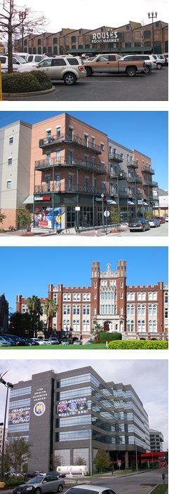
Commercial Center and Institutional Campus Districts represent the major destination areas within the city. They contain districts that address areas of commercial concentration and institutional campuses, and range from areas that are more pedestrian in orientation to those designed to accommodate significant parking demand. The types of commercial uses permitted within the Commercial Center and Institutional Campus Districts are based on a number of factors, including their proximity to residential areas, their location along major streets and the intensity of uses allowed within the districts. In addition to commercial districts that allow a variety of retail, personal service, office, and restaurant uses, specialized districts for large-scale users are also destination centers, such as hospital and university campuses. Finally, in certain districts a mixed-use environment is permitted where higher density residential uses and vertical mixed-use is encouraged.
Commercial Center and Institutional Campus Districts contain regulations that create and maintain intensive mixed employment, shopping, and entertainment destination environments. Controls within the districts address proper scales of development based on the desired intensity of the district, including regulations on parking, landscape, and screening.
CHARACTER OF THE COMMERCIAL CENTER AND INSTITUTIONAL CAMPUS DISTRICTS
The character of the Commercial Center and Institutional Campus Districts is defined by:
» Concentrations of retail, service, office, and entertainment uses both along major thoroughfares and at commercial nodes
» A variety of commercial district types – from pedestrian-oriented commercial corridors to larger shopping centers
» Large-scale campuses, such as hospitals and universities, that contain a variety of uses and activities on site
» Mixed-use development, including residences above ground floor commercial and higher density dwelling types
15.1 Purpose Statements
15.1.A Purpose of the C-1 General Commercial District
The C-1 General Commercial District is intended to provide appropriate locations for a variety of commercial activities, generally serving a wide area and located particularly along commercial corridors with a mix of commercial, service, and residential activities. Areas of the C-1 District are oriented toward pedestrians but also accommodate larger commercial uses generally accessed by automobiles.
15.1.B Purpose of the C-2 Auto-Oriented Commercial District
The C-2 Auto-Oriented Commercial District is intended for a wide variety of commercial activities, generally serving a wide area and located along major arterials. The C-2 District is intended for large-scale, auto-oriented commercial uses and strip commercial developments, which require significant parking. The C-2 District is also intended to accommodate marine-oriented commercial and recreational uses along major bodies of water.
15.1.C Purpose of the C-3 Heavy Commercial District
The C-3 Heavy Commercial District is intended to provide for auto-oriented heavy commercial uses and large-scale shopping centers. Standards for the C-3 District are designed to maintain and enhance the appearance of these areas, and to provide adequate buffering between any residential and lower-intensity commercial properties adjacent to the district.
15.1.D Purpose of the MU-1 Medium Intensity Mixed-Use District
The MU-1 Medium Intensity Mixed-Use District is intended to encourage walkable neighborhood centers and corridors, with a mix of residential and commercial uses. Buildings may contain vertical mixed-use as well as single purpose uses designed to provide transitions to adjacent lower density residential areas.
15.1.E Purpose of the MU-2 High Intensity Mixed-Use District
The MU-2 High Intensity Mixed-Use District is intended encourage walkable neighborhood centers and corridors conducive to transit, with a mix of residential and supportive commercial and office uses. Buildings may contain vertical mixed-use as well as single purpose uses designed to be located both at neighborhood centers and along major arterial corridors.
15.1.F Purpose of the EC Educational Campus District
The EC Educational Campus District is intended for large university campus developments to facilitate an orderly and efficient regulation process for these types of uses. The district establishes a process that is flexible enough to accommodate evolving changes and expansions in campus plans, and creates the proper transitions between campus activities and adjacent neighborhoods. Within the district, development will proceed in accordance with an approved Institutional Master Plan that relates to the adjacent district, the surrounding neighborhoods, and needs of the universities.
15.1.G Purpose of the MC Medical Campus District
The MC Medical Campus District is intended for medical campuses and the accompanying medical-related support services, including offices, research facilities and commercial uses, to facilitate an orderly and efficient regulation process for these types of uses. The district establishes a process that is flexible enough to accommodate evolving changes and expansion in medical campus plans, and creates the proper transitions between hospital activities and adjacent neighborhoods. Within the district, development will proceed in accordance with an approved Institutional Master Plan that relates to the adjacent district, the surrounding neighborhoods, and needs of the hospital.
15.1.H Purpose of the MS Medical Service District
The MS Medical Service District is intended for local hospitals and medical service facilities of lower intensity than large medical campuses. The MS District is intended for hospitals, and hospital-related and support services that are generally integrated within and connected to adjacent areas of commercial and residential development.
15.1.I Purpose of the LS Life Science Mixed-Use District
The LS Life Science Mixed-Use District is intended to provide a district that is focused on life sciences research, including research, development, medical and limited manufacturing activity. In addition to life science research and development uses, the area is also intended to be more mixed-use in nature, by also allowing higher density residential and supportive commercial uses to serve those that live and work within the district.
15.1.J Purpose of the Commercial Center & Institutional Mandatory Inclusionary Zoning Sub-Districts
The Commercial Center and Institutional Mandatory Inclusionary Zoning Sub-Districts are intended to include mandatory affordable housing requirements, in accordance with Article 28, in districts that allow the development of ten or more dwelling units.
Adopted by Ord. 28036 MCS, Sec. 1, March 28, 2019, ZD 112/18
15.2 Uses
15.2.A Permitted and Conditional Uses
Only those uses of land listed under Table 15-1: Permitted and Conditional Uses as permitted uses or conditional uses are allowed within the Commercial Center and Institutional Campus Districts. A “P” indicates that a use is permitted within that zoning district. A “C” indicates that a use is a conditional use in that zoning district and would require a conditional use approval as required in Section 4.3 (Conditional Use). For conditional uses in the EC and MC Districts, Institutional Master Plan approval, in accordance with Section 15.5 is also required. No letter (i.e., a blank space), or the absence of the use from the table, indicates that use is not permitted within that zoning district.
Table 15-1: Permitted and Conditional Uses
| Table 15-1: Permitted and Conditional Uses |
|
USES1
|
DISTRICTS
|
USE STANDARDS
|
|
C-1
|
C-2
|
C-3
|
MU-1
|
MU-2
|
EC3
|
MC
|
MS
|
LS
|
|
RESIDENTIAL USE
|
|
Bed and Breakfast – Accessory
|
|
|
|
C
|
C
|
C
|
|
|
|
Section 20.3.I
|
|
Bed and Breakfast – Principal
|
|
|
|
C
|
C
|
|
|
|
|
Section 20.3.I
|
|
Day Care Home, Adult – Small
|
|
|
|
P
|
P
|
|
|
|
|
Section 20.3.T
|
|
Day Care Home, Adult - Large
|
|
|
|
P
|
P
|
|
|
|
|
Section 20.3.T
|
|
Dormitory
|
|
|
|
|
|
P
|
P
|
P
|
P
|
|
|
Dwelling, Above the Ground Floor
|
C
|
C
|
C
|
P
|
P
|
|
|
|
P
|
|
|
Dwelling, Single-Family
|
|
|
|
P
|
P
|
P
|
|
|
|
|
|
Dwelling, Two-Family
|
|
|
|
P
|
P
|
P
|
|
|
|
Section 20.3.Y
|
|
Dwelling, Townhouse
|
|
|
|
P
|
P
|
|
|
|
|
Section 20.3.X
|
|
Dwelling, Multi-Family
|
|
|
|
P
|
P
|
P
|
P
|
|
P
|
|
| Dwelling, Small Multi-Family Affordable |
|
|
|
P |
P |
|
|
|
|
Section 20.3.SSS |
|
Dwelling, Existing Single-Family
|
P
|
P
|
P
|
|
|
|
|
P
|
|
|
|
Dwelling, Established Two-Family
|
P/C7
|
P/C7
|
P/C7
|
|
|
|
|
P
|
|
Section 20.3.W
|
|
Dwelling, Established Multi-Family
|
P/C7
|
P/C7
|
P/C7
|
|
|
|
|
P
|
|
Section 20.3.W
|
|
Fraternity/Sorority
|
|
|
|
|
|
P
|
|
|
|
Section 20.3.DD
|
|
Group Home, Small
|
|
|
|
P
|
P
|
|
P
|
|
|
Section 20.3.GG
|
|
Group Home, Large
|
|
|
|
P
|
P
|
|
P
|
|
P
|
Section 20.3.GG
|
|
Group Home, Congregate
|
|
|
|
C
|
C
|
|
P
|
|
|
Section 20.3.GG
|
| Home Based Child Care, Small |
|
|
|
P |
P |
|
|
|
|
Section 20.3.T |
| Home Based Child Care, Large |
|
|
|
P |
P |
|
|
|
|
Section 20.3.T |
|
Permanent Supportive Housing
|
|
|
|
P
|
P
|
P
|
P
|
|
P
|
Section 20.3.PP
|
|
Residential Care Facility
|
P
|
P
|
|
P
|
P
|
|
P
|
P
|
P
|
Section 20.3.YY
|
| Timeshare |
|
C |
|
C |
|
|
C |
C |
C |
|
|
COMMERCIAL USE
|
|
Amusement Facility, Indoor
|
P
|
P
|
P
|
P
|
P
|
P
|
|
|
|
Section 20.3.E
|
|
Amusement Facility, Outdoor
|
|
C
|
P
|
C
|
P
|
C
|
|
|
|
Section 20.3.E
|
|
Art Gallery
|
P
|
P
|
P
|
P
|
P
|
P
|
|
|
|
|
|
Arts Studio
|
P
|
P
|
P
|
P
|
P
|
P
|
|
|
|
|
|
Animal Hospital
|
P
|
P
|
P
|
P
|
P
|
|
|
|
|
|
|
Auditorium
|
|
|
|
P
|
P
|
C
|
C
|
P
|
P
|
|
|
Bar
|
C
|
P
|
P
|
C
|
P
|
|
|
|
P
|
Section 20.3.G
|
|
Broadcast Studio
|
|
|
P
|
P
|
P
|
P
|
|
|
|
|
|
Bus Terminal
|
C
|
C
|
C
|
C
|
C
|
|
|
|
|
|
|
|
Car Wash
|
C
|
C
|
P
|
C
|
C
|
|
|
|
|
Section 20.3.L
|
|
|
Catering Kitchen
|
P
|
P
|
P
|
P
|
P
|
P
|
P
|
P
|
P
|
|
|
Check Cashing Establishment
|
P
|
P
|
P
|
P
|
P
|
|
|
|
P
|
Section 20.3.O
|
| Child Care Center, Small |
P |
P |
P |
P |
P |
P |
P |
P |
P |
Section 20.3.S |
| Child Care Center, Large |
P |
P |
P |
P |
P |
P |
P |
P |
P |
Section 20.3.S |
|
Convention Center
|
|
|
|
|
C
|
|
|
|
|
|
|
Day Care Center, Adult or Child - Small
|
P
|
P
|
P
|
P
|
P
|
P
|
P
|
P
|
P
|
Section 20.3.S
|
|
Day Care Center, Adult - Large
|
P
|
P
|
P
|
P
|
P
|
P
|
P
|
P
|
P
|
Section 20.3.S
|
|
Day Care Center, Adult - Commercial
|
P
|
P
|
P
|
P
|
P
|
P
|
P
|
P
|
P
|
Section 20.3.S
|
|
Drive-Through Facility
|
|
P
|
P
|
C
|
C
|
|
|
|
C
|
Section 20.3.V
|
|
Employment Services
|
|
C
|
C
|
|
|
|
|
|
P
|
Section 20.3.BB
|
|
Financial Institution
|
P
|
P
|
P
|
P
|
P
|
P
|
P
|
|
P
|
|
|
Funeral Home
|
P
|
P
|
P
|
P
|
P
|
|
|
|
|
|
|
Greenhouse/Nursery
|
|
|
P
|
C
|
P
|
|
|
|
|
|
|
|
Gas Station
|
C
|
P
|
P
|
C
|
C
|
|
|
|
|
Section 20.3.EE
|
|
| Grocery Store |
P |
P |
P |
P |
P |
P |
P |
P |
P |
|
|
Health Club
|
P
|
P
|
P
|
P
|
P
|
P
|
P
|
|
|
|
|
Heavy Sales, Rental & Service
|
|
|
P
|
|
C
|
|
|
|
|
|
|
Hostel
|
P/C8
|
P
|
P
|
P
|
P
|
P
|
P
|
|
P
|
|
|
Hotel/Motel
|
P
|
P
|
P
|
P
|
P
|
P
|
P
|
P
|
P
|
|
|
Kennel
|
|
|
C
|
C
|
C
|
|
|
|
|
Section 20.3.II
|
|
|
Live Entertainment – Secondary Use
|
C
|
P9
|
C
|
C
|
P9
|
|
|
|
|
Section 20.3.JJ
|
|
|
Live Performance Venue
|
C
|
C
|
P
|
C
|
P
|
|
|
|
|
Section 20.3.JJ
|
|
|
Medical/Dental Clinic
|
P
|
P
|
P
|
P
|
P
|
P
|
P
|
P
|
P
|
|
|
Micro-Brewery
|
P
|
P
|
P
|
P
|
P
|
|
|
|
|
|
|
Micro-Distillery
|
P
|
P
|
P
|
P
|
P
|
|
|
|
|
|
|
Motor Vehicle Dealership, Large
|
C
|
P
|
P
|
|
C
|
|
|
|
|
Section 20.3.LL
|
|
|
Motor Vehicle Operations Facility
|
|
|
P
|
C
|
C
|
C
|
C
|
P
|
|
|
|
|
Motor Vehicle Rental Establishment
|
C
|
P
|
P
|
|
C
|
|
|
|
|
Section 20.3.LL
|
|
|
Motor Vehicle Service & Repair, Minor
|
C
|
P
|
P
|
P
|
P
|
|
|
|
|
Section 20.3.MM
|
|
Motor Vehicle Service & Repair, Major
|
|
C
|
P
|
|
C
|
|
|
|
|
Section 20.3.MM
|
|
Movie Studio
|
|
|
P
|
C
|
P
|
|
|
|
|
|
|
|
Office
|
P
|
P
|
P
|
P
|
P
|
P
|
P
|
P
|
P
|
|
| Outdoor Amphitheater |
|
C |
C |
|
|
|
|
|
|
Section 20.3.VVV |
| Outdoor Live Entertainment - Secondary Use |
C |
C |
C |
C |
C |
C |
C |
C |
C |
Section 20.3.WWW |
|
Pawn Shop
|
|
|
P
|
|
|
|
|
|
|
Section 20.3.O
|
|
Personal Service Establishment
|
P
|
P
|
P
|
P
|
P
|
P
|
P
|
P
|
P
|
|
|
Pet Day Care Service
|
P
|
P
|
P
|
P
|
P
|
|
|
|
|
Section 20.3.QQ
|
|
Printing Establishment
|
|
|
P
|
|
P
|
|
|
|
|
|
|
Public Market
|
P
|
P
|
P
|
P
|
P
|
P
|
|
|
|
Section 20.3.TT
|
|
Reception Facility
|
C
|
P
|
P
|
P
|
P
|
|
|
|
|
Section 20.3.WW
|
|
Recording Studio
|
P
|
P
|
P
|
P
|
P
|
P
|
P
|
P
|
P
|
|
|
Recreational Vehicle Park
|
|
C
|
P
|
|
|
|
|
|
|
Section 20.3.XX
|
|
Restaurant, Carry-Out
|
P
|
P
|
P
|
P
|
P
|
C
|
C
|
|
P
|
Section 20.3.ZZ
|
|
Restaurant, Fast Food
|
P
|
P
|
P
|
C
|
P
|
C
|
C
|
|
P
|
Section 20.3.ZZ
|
|
Restaurant, Standard
|
P
|
P
|
P
|
P
|
P
|
P
|
P
|
P
|
P
|
Section 20.3.ZZ
|
|
Restaurant, Specialty
|
P
|
P
|
P
|
P
|
P
|
P
|
P
|
P
|
P
|
Section 20.3.ZZ
|
|
Retail Goods Establishment
|
P
|
P
|
P
|
P
|
P
|
P
|
P
|
P
|
P
|
|
|
Retail Sales of Packaged Alcoholic Beverages
|
C
|
C
|
P
|
C
|
C
|
|
|
|
C
|
|
| Shooting Range, Indoor |
|
C |
C |
|
|
|
|
|
|
Section 20.3.RRR |
| Short Term Rental, Commercial |
P |
P |
P |
P |
P |
P |
P |
P |
P |
Section 20.3.LLL |
| Small Box Variety Store |
P |
P |
P |
P |
P |
P |
P |
P |
P |
Section 20.3.NNN |
|
Stadium
|
|
|
|
|
|
C
|
|
|
|
|
|
Winery
|
P
|
P
|
P
|
P
|
P
|
|
|
|
|
|
|
|
INDUSTRIAL USE
|
|
Brewery
|
P5
|
P5
|
P5
|
P5,C6
|
P5
|
|
|
|
|
|
|
Contractor Storage Yard
|
|
C
|
C
|
|
|
|
|
|
|
Section 20.3.Q
|
| Convenience Center |
P |
P |
P |
|
|
|
|
|
|
Section 20.3.TTT |
| Distillery |
P5 |
P5 |
P5 |
P5,C6 |
P5 |
|
|
|
|
|
| District Energy System |
|
|
|
C |
C |
|
P |
P |
|
Section 20.3.QQQ |
|
Food Processing
|
P
|
P
|
P
|
C
|
P
|
|
|
|
|
|
|
Helistop
|
|
|
|
|
|
|
P
|
P
|
P
|
Section 20.3.D
|
|
|
Heliport
|
|
|
|
|
|
|
C
|
C
|
C
|
Section 20.3.D
|
|
| Mardi Gras Den |
|
P |
P |
P |
C |
P |
|
|
|
|
|
Marina, Commercial
|
|
P
|
|
|
|
|
|
|
|
|
|
|
Marina, Recreational
|
|
P
|
|
|
|
|
|
|
|
|
|
|
Manufacturing, Artisan
|
|
|
P
|
P
|
P
|
|
|
|
|
|
|
Manufacturing, Light
|
|
|
|
C
|
P
|
|
|
|
P
|
|
|
Mini-Warehouse
|
|
C
|
P
|
C
|
C
|
|
|
|
|
|
|
Outdoor Storage Yard
|
|
|
C
|
|
|
|
|
|
|
Section 20.3.Q
|
|
Research & Development
|
|
|
P
|
P
|
P
|
P
|
P
|
P
|
P
|
|
| Solar Energy System |
P |
P |
P |
P |
P |
P |
P |
P |
P |
Section 20.3.DDD |
|
Warehouse
|
|
|
P
|
C
|
P
|
|
|
|
P
|
|
|
INSTITUTIONAL USE
|
| City Hall |
C |
C |
C |
C |
C |
C |
C |
C |
C |
|
|
Community Center
|
P
|
P
|
P
|
P
|
P
|
P
|
P
|
|
|
|
|
|
Convent and Monastery
|
P
|
P
|
P
|
P
|
P
|
P
|
|
|
|
|
|
Cultural Facility
|
P
|
P
|
P
|
P
|
P
|
P
|
P
|
|
|
Section 20.3.R
|
|
|
Domestic Protection Shelter
|
|
|
C
|
P
|
P
|
P
|
P
|
P
|
P
|
Section 20.3.U
|
|
|
Educational Facility, Primary
|
P
|
P
|
P
|
P
|
P
|
P
|
|
|
|
Section 20.3.Z
|
|
|
Educational Facility, Secondary
|
P
|
P
|
P
|
P
|
P
|
P
|
|
|
|
Section 20.3.Z
|
|
|
Educational Facility, University
|
C
|
C
|
C
|
P
|
P
|
P
|
P
|
|
C
|
|
|
|
Educational Facility, Vocational
|
C
|
P
|
P
|
P
|
P
|
P
|
|
|
C
|
Section 20.3.Z
|
|
|
Emergency Shelter
|
|
|
C
|
P
|
P
|
P
|
P
|
P
|
P
|
Section 20.3.AA
|
|
|
Government Offices
|
P
|
P
|
P
|
P
|
P
|
P
|
P
|
P
|
P
|
|
|
|
Hospital
|
|
C
|
C
|
C
|
C
|
P
|
P
|
P
|
P
|
|
|
Place of Worship
|
P
|
P
|
P
|
P
|
P
|
P
|
P
|
P
|
|
|
|
Public Works and Safety Facility
|
C
|
C
|
C
|
C
|
C
|
|
|
|
P
|
|
|
Social Club or Lodge
|
P
|
P
|
P
|
P
|
P
|
P
|
P
|
P
|
P
|
Section 20.3.CCC
|
|
OPEN SPACE USE
|
|
Agriculture – No Livestock
|
|
|
|
P
|
P
|
P
|
P
|
|
P
|
Section 20.3.C
|
|
Agriculture – With Livestock
|
|
|
|
C
|
C
|
C
|
C
|
|
C
|
Section 20.3.C
|
| Cemetery |
|
|
|
C,P11 |
|
|
|
|
|
Section 20.3.N |
|
Parks and Playgrounds
|
P
|
P
|
P
|
P
|
P
|
P
|
P
|
P
|
P
|
|
|
|
Stormwater Management (Principal Use)
|
P
|
P |
P |
P |
P |
P |
P |
P |
P |
|
|
|
OTHER
|
|
|
|
|
|
|
|
|
|
|
| EV Charging Station (Principal Use) |
P |
P |
P |
P |
P |
P |
P |
P |
P |
Section 20.3.YYY |
| Parking Lot (Accessory Use) |
P10 |
P10 |
P10 |
P10 |
P10 |
P10 |
P10 |
P10 |
P10 |
|
|
Parking Lot (Principal Use)
|
C
|
C
|
C
|
C
|
C
|
P
|
P
|
P
|
P
|
Section 20.3.OO
|
|
|
Parking Structure (Principal Use)
|
C
|
C
|
C
|
C
|
C
|
P
|
P
|
P
|
P
|
Section 20.3.OO
|
|
|
Planned Development
|
C
|
C
|
C
|
C
|
C
|
|
|
|
C
|
Article 5
|
|
Pumping Station
|
P
|
P
|
P
|
P
|
P
|
P
|
P
|
P
|
P
|
Section 20.3.UU
|
|
Utilities
|
P2
|
P2
|
P2
|
P2
|
P2
|
P
|
P
|
P2
|
P2
|
Section 20.3.GGG
|
|
|
Wireless Telecommunications Antenna & Facility
|
P4
|
P4
|
P4
|
C,P4
|
C,P4
|
P
|
P
|
P4
|
P4
|
Section 20.3.JJJ
|
|
|
Wireless Telecommunications Tower & Facility
|
P
|
P
|
P
|
C
|
C
|
P
|
P
|
C
|
C
|
Section 20.3.JJJ
|
|
TABLE 15-1 FOOTNOTES
1 The terms in this column (“Use”) are defined in Article 26.
2 Electrical Utility Substations and Transmission Lines shall be subject to design review as per Article 4, Section 4.5.B.5 and Table 4-2.
3 See Section 15.2.C.
4 Only wireless telecommunications antennas that comply with the stealth design standards of Section 20.3.JJJ are considered permitted uses.
5 Subject to the use restrictions in Section 15.2.B.1.
6 Subject to the use restrictions in Section 15.2.B.2.
7 Established Two-Family Dwellings and Established Multi-Family Dwellings that comply with Section 20.3.W.1 are permitted uses while those that comply with Section 20.3.W.2 are conditional uses.
8 Subject to the use restriction in Section 15.2.B.3
9 Classified as a Conditional Use in Breweries.
10As authorized in Article 22, Section 22.8.B.2.a
11Only cemeteries that comply with all use standards of Section 20.3.N are considered permitted uses.
Adopted by Ord. No. 27,209, §1, Dec. 7, 2016, Zoning Docket 61/16; Ord. No. 27,375, §6, April 28, 2017, Zoning Docket 118/16; Ord. No. 27,338, §4, March 31, 2017, Zoning Docket 121/16; Ord. No. 27,762, §1, May 11, 2018, Zoning Docket 23/18; Ord. No. 27,707, §1, April 2, 2018, Zoning Docket 001/18; Ord. No. 27,759, §1, May 11, 2018, Zoning Docket 006/18; Ord. 28176, Sept. 5, 2019, ZD 59/19; Ord. 28219 MCS, Oct. 17, 2019, ZD 45/19; Ord No 28,156 MCS, §9, August 8, 2019, Zoning Docket 26/19 & 27/19; Ord. 28,322 MCS, §2, February 28, 2020, Zoning Docket 117-19; Ord. 28432 MCS, 8-6-20, ZD 38/20; Ord. 28622, 3-11-21, ZD 83/20; Ord. 28696 MCS, 6-3-21, ZD 16/21; Ord. 28736 MCS, 7-15-21, ZD 17/21; Ord 28905 MCS, 1-6-22, ZD 83/21; Ord. No. 28,911, §7, January 6, 2022, Zoning Docket 084/21; Ord 28967 MCS, 3-10-22, ZD 107/21; Ord. 29126, 8-12-22, ZD016/22; Ord. 28963, 3-10-22, ZD 78/21; Ord 29157 9-15-22, ZD 030/22; Ordinance No. 29382, March 23, 2023, Zoning Docket 02/23; Ord. 29528, 7-24-23, Zoning Docket 13/23; Ordinance No. 29702, November 7, 2023, Zoning Docket 063/23; Ord. No 29744, 12-8-23, Zoning Docket 055/23
15.2.B Use Restrictions
15.2.B.1 Breweries in the C-1, C-2, C-3, MU-1, and MU-2 Districts
In the C-1, C-2, C-3, MU-1, and MU-2 Districts, only breweries and distilleries that produce fewer than 12,500 barrels per year are considered permitted uses.
Adopted by Ord. 28696 MCS, 6-3-21, ZD 16/21
15.2.B.2 Breweries in the MU-1 District
In the MU-1 District, breweries and distilleries that produce more than 12,500 barrels per year are considered conditional uses.
Adopted by Ord. 28696 MCS, 6-3-21, ZD 16/21
15.2.B.3 Hostels in the C-1 District
Hostels in a C-1 District that are adjacent to a residential district are conditional uses. Otherwise, hostels are permitted uses in the C-1 District.
Adopted by Ord. No. 27,759, §1, May 11, 2018, Zoning Docket 006/18
15.2.C Uses Associated With Colleges and Universities in the EC District
In addition to the permitted and conditional uses listed in Table 15-1 for the EC District, Colleges and Universities and uses normally associated therewith are permitted in the EC District when part of an approved Institutional Master Plan.
15.3 Site Design Standards
15.3.A Bulk and Yard Regulations
15.3.A.1 General Regulations
Table 15-2: Bulk and Yard Regulations establishes bulk and yard regulations for the Commercial Center and Institutional Campus Districts.
Table 15-2: Bulk & Yard Regulations
| Table 15-2: Bulk & Yard Regulations |
|
BULK & YARD REGULATIONS1
|
C-1
|
C-2
|
C-3
|
MU-1
|
MU-2
|
EC
|
MC
|
MS
|
LS
|
|
BULK REGULATIONS
|
|
|
MINIMUM LOT AREA
|
Dwelling, Above the Ground Floor: 1,000sf/du
Non-Residential: 3,000sf
|
Dwelling, Above the Ground Floor: 1,000sf/du
Non-Residential 5,000sf
|
Dwelling, Above the Ground Floor: 800sf/du
Non Residential: 5,000sf
|
SF: 3,000sf/du
2F: 1,700sf/du
MF: 1,000sf/du
Small MF Affordable: None
Townhouse: 2,000sf/du
Non-Residential: None
|
SF: 3,000sf/du
2F: 1,700sf/du
MF: 800sf/du
Small MF Affordable: None
Townhouse: 1,800sf/du
Non-Residential: None
|
SF & 2F: Equal to that of the most restrictive adjacent residential district. All other uses: 2 acres
|
SF & 2F: Equal to that of the most restrictive adjacent residential district. All other uses: 2 acres.
|
None
|
5,000sf
|
|
A
|
MAXIMUM BUILDING HEIGHT
|
40’ & no more than 3 stories
|
40’ & no more than 3 stories
|
130’ & no more than 12 stories
|
SF & 2F: 35’
Townhouse: 40’ & no more than 3 stories
MF & Non-Residential: 60’ & no more than 5 stories
|
SF & 2F: 35’
Townhouse: 40’ & no more than 3 stories
MF & Non-Residential: 85’ & no more than 7 stories
|
Limited to 2 times the most restrictive height of adjacent districts; height may be increased by 1’ for each additional foot of setback from the required yard; additional height may be obtained through the conditional use process
|
Limited to 2 times the most restrictive height of adjacent districts; height may be increased by 1’ for each additional foot of setback from the required yard
|
When adjacent to residential district: Maximum height of adjacent residential district - may exceed this height by 20 ft when the structure is set back 3’ from residential district line for each additional 5’ in building height
When adjacent to non-residential district: 100’
|
100’, unless adjacent to a residential district then 50’ but may exceed 50’ if set back 1’ for each foot above 50’ up to 100’
|
| |
MINIMUM PERMEABLE OPEN SPACE |
20% of the lot area |
20% of the lot area |
20% of the lot area |
20% of the lot area |
20% of the lot area |
30% of the lot area |
30% of the lot area |
30% of the lot area |
30% of the lot area |
|
MINIMUM YARD REQUIREMENTS
|
|
B
|
FRONT YARD
|
Section 15.3.A.2
|
Section 15.3.A.2
|
Section 15.3.A.2
|
Section 15.3.A.2
|
Section 15.3.A.2
|
SF & 2F: Equal to that of the most restrictive adjacent residential district. All other uses: 10’
|
SF and 2F: Equal to that of the most restrictive adjacent residential district. All other uses: 10’
|
20’
|
Section 15.3.A.2
|
| C |
INTERIOR SIDE YARD |
None, unless abutting a residential district then 5' |
5' |
10' |
SF & 2F: 10% of lot width or 3’, whichever is greater
Townhouse: 10’
MF & Non-Residential/Mixed-Use: None, unless abutting a residential district then 5’ |
SF & 2F: 10% of lot width or 3’, whichever is greater
Townhouse: 10’
MF & Non-Residential/Mixed Use: None, unless abutting a residential district then 5’ |
SF & 2F: Equal to that of the most restrictive adjacent residential district. All other uses: 10’, unless abutting residential district then 25’ |
SF and 2F: Equal to that of the most restrictive adjacent residential district. All other uses: 10’, unless abutting residential district then 25’ |
10' |
None, unless abutting residential district then 10’ |
| D |
CORNER SIDE YARD |
None |
10' |
10' |
None |
None |
SF & 2F: Equal to that of the most restrictive adjacent residential district. All other uses: 10' |
SF & 2F: Equal to that of the most restrictive adjacent residential district. All other uses: 10' |
10' |
None to a maximum of 20' |
| E |
REAR YARD |
None, unless abutting a residential district then 20’ |
25' |
25' |
Residential: 20’
Non-Residential/Mixed-Use: None, unless abutting a residential district then 20’ |
Residential: 20’
Non-Residential/Mixed-Use: None, unless abutting a residential district then 20’ |
SF & 2F: Equal to that of the most restrictive adjacent residential district. All other uses: 20’, unless abutting residential district then 35’ |
SF & 2F: Equal to that of the most restrictive adjacent residential district. All other uses: 20’, unless abutting residential district then 35’ |
10' |
10’, unless abutting residential district then 20’ |
TABLE 15-2 FOOTNOTES
1 If a property abuts more than one zoning district, the more restrictive yard requirement applies.
Table 15-3: The Mandatory Inclusionary Zoning Sub-District (MIZ) regulations establish mandatory inclusionary unit thresholds, set aside requirements, and Area Medium Income (AMI) levels and is required for any development that contains residential development of 10 or more dwelling units, including rental and homeownership dwelling units. Affordable Housing Units shall be in accordance with the standards outlined in the table below. All other bulk and yard regulations for the sub-districts are subject to the corresponding non-inclusionary zoning base district regulations.
|
Table 15-3: Commercial Center & Institutional Campus Inclusionary Zoning
Sub-District Regulations1
|
|
Zoning Sub-District
|
Minimum Lot Area Requirement
|
Affordable Housing Unit Threshold
|
Set Aside Requirement %
|
Area Medium Income (AMI) Rental Units (%)
|
Area Medium Income AMI Homeownership (%)
|
|
C-1-IZ
|
NA2
|
10
|
5
|
60
|
60
|
|
C-2-IZ
|
NA2
|
10
|
5
|
60
|
60
|
|
C-3-IZ
|
NA2
|
10
|
5
|
60
|
60
|
|
MU-1-IZ
|
1,000 sf/du
|
10
|
5
|
60
|
60
|
|
MU-2-IZ
|
800 sf/du
|
10
|
5
|
60
|
80
|
TABLE 15-3 FOOTNOTES
1The terms for the Mandatory Inclusionary Zoning Sub-Districts in this section are outlined in Article 28.
2The minimum lot area requirements for properties in these districts are non-applicable. Multi-family development is only permitted above the ground floor and developments are subject to the development standards in Table 14-2: Bulk and Yard Regulations.
.


Adopted by Ord. No. 27,722, §8, April 11, 2018, Zoning Docket 113/17; Ord No. 027883, §1, October 10, 2018, Zoning Docket 079/18; Ord. 28036 MCS, Sec. 1, March 28, 2019, ZD 112/18; Ord. No. 28,911, §7, January 6, 2022, Zoning Docket 084/21
15.3.A.2 Front Yard Build-To Line Requirement
a. Within the C-1, C-2, C-3, MU-1, MU-2 and LS Districts of the Commercial Center and Institutional Campus Districts, the front yard build-to line is established by any one (1) of the following methods. A build-to line is an established setback line at which a structure is required to build. However, in no case may the front yard exceed twenty (20) feet.
i. As of the effective date of this Ordinance, the current front yard of the existing structure may be set as the required front yard build-to line. When a structure is demolished, the demolition permit shall indicate the dimension of the front yard prior to demolition. The required front yard build-to line is that indicated on the demolition permit.
ii. The required front yard build-to line indicated on the most recent survey or Sanborn maps.
iii. The average of the front yard of the adjacent lots on either side may be used to establish the required front yard build-to line. Averaging is based on the two (2) adjacent lots or, in the case of a corner lot, two (2) neighboring lots on the same blockface. In the case of a lot configuration where only one (1) lot is available for averaging, the front yard build-to line is that of the adjacent lot. (See Figure 15-1: Front Yard Averaging)
b. The applicant is permitted a three (3) foot variation from a front yard build-to line established by any of the above methods.
c. The required front yard build-to line is measured as the narrowest dimension from the front lot line to the principal structure. The measurement is taken from the building walls of the principal structure and does not include permitted encroachments or architectural features.
d. Should the calculation of the required front yard setback be unable to be determined by the methods identified in item a above, the Director of the Department of Safety and Permits shall determine the setback based on his/her judgement given the development pattern in the immediate surrounding area.
FIGURE 15-1: FRONT YARD AVERAGING

15.3.B Building Design Standards
1. The following building design standards apply to development within the C-1, C-2, C-3, MU-1, MU-2, and LS Districts, with the exception of single and two family residential uses.
a. The primary entrances shall be oriented to the primary street.
b. The ground floor of newly constructed commercial buildings shall contain a minimum transparency of fifty percent (50%) on the primary street and windows shall be constructed of transparent glass. Opaque, highly tinted, or reflective glass is prohibited. Transparency into the building shall be maintained. Any window signs shall consist of individual letters and numerals without the use of any background.
c. Security bars, if installed, shall be on the inside of windows. Roll-up or accordion security grilles are permitted on the ground floor when constructed of a see-through, non-solid material. The Casing shall be painted to match the building and shall not damage or obscure architectural detailing.
d. Plain mansard roofs are prohibited. Decorative mansard roofs are permitted on buildings with a minimum wall height of two (2) stories. (See Figure 15-2: Examples of Decorative Mansard Roofs).
e. Decorative elements having historically functional purposes, such as shutters, balconies, windows, and doors, shall be operational.
f. Any structure designed for a ground floor non-residential use shall be designed with a minimum ceiling height of twelve (12) feet, except for parking areas.
g. Loading areas for retail anchor stores of twelve thousand (12,000) square feet in gross floor area or more are required to be located in the rear.
h. Outlot buildings shall be designed with showcase windows and entrances oriented to the street.
i. Secondary access points are encouraged from rear parking lots. Facades that abut parking areas and contain a public entrance shall include pedestrian walkways.
j. When a shopping center is located behind a parking lot, a street presence for the shopping center shall be created by locating part of the center and/or outlot buildings near the lot line at the primary street corner or the shopping center entrance. When the center’s frontage on the primary street exceeds two-hundred fifty (250) feet in width, part of the center and/or outlot buildings shall hold at least fifty percent (50%) of the front lot line. (See Figure 15-3: Building Siting).
k. The following building materials are prohibited on exterior elevations visible from the public right-of-way. However, such materials may be used as part of decorative or detail elements, or as part of the exterior construction that is not used as a surface finish material.
1. Exterior insulating finish systems (EIFS)
2. Stuccato Board
3. Vinyl
FIGURE 15-2: EXAMPLES OF DECORATIVE MANSARD ROOFS

FIGURE 15-3: BUILDING SITING

2. The following standards shall apply to all sites that meet the applicability thresholds of Section 4.5 Development Plan and Design Review:
a. A cohesive shopping center character is required through the use of coordinated hardscape treatment, such as special paving materials, lighting, and street furniture, coordinated signs and landscape. Pedestrian areas shall include shade trees and seating areas.
b. Public entrances shall be articulated from the structure mass.
c. Shopping centers with frontage on the primary street that exceeds two-hundred fifty (250) feet in width and a lot depth of three-hundred (300) feet or more are encouraged to construct an access road with parallel parking along that primary street. If an access road is constructed, retail storefronts shall be oriented to this access road.
d. Structures shall use decorative roof elements, such as projecting cornices, to define public entrances, main pedestrian routes or activity areas.
e. When visible from the public right-of-way (excluding alleys), façades shall include architectural features to avoid the appearance of blank walls facing the street. These include, but are not limited to, changes in the wall plane of at least six (6) inches, changes in wall texture or masonry patterns, colonnade, columns, or pilasters.
f. Windows along the street shall be set back into or projected out from the façade to provide depth and shadow.
g. Green roof, blue roof, and white roof designs are encouraged.
Adopted by Ord. 29126, 8-12-22, ZD016/22
15.4 Commercial Center and Institutional Campus Districts Illustratives and Site Diagrams
15.4.A C-1 District
The siting and design requirements for buildings in the C-1 District are illustrated in Figure 15-4: C-1 District Illustrative and Site Diagram.
FIGURE 15-4: C-1 DISTRICT ILLUSTRATIVE AND SITE DIAGRAM C-1 DISTRICT OPTION 1

FIGURE 15-4: C-1 DISTRICT ILLUSTRATIVE AND SITE DIAGRAM C-1 DISTRICT OPTION 2

15.4.B C-2 District
The siting and design requirements for buildings in the C-2 District are illustrated in Figure 15-5: C-2 District Illustrative and Site Diagram.
FIGURE 15-5: C-2 DISTRICT ILLUSTRATIVE AND SITE DIAGRAM C-2 DISTRICT OPTION 1

FIGURE 15-5: C-2 DISTRICT ILLUSTRATIVE AND SITE DIAGRAM C-2 DISTRICT OPTION 2

15.4.C C-3 District
The siting and design requirements for buildings in the C-3 District are illustrated in Figure 15-6: C-3 District Illustrative and Site Diagram.
FIGURE 15-6: C-3 DISTRICT ILLUSTRATIVE AND SITE DIAGRAM C-3 DISTRICT OPTION 1

FIGURE 15-6: C-3 DISTRICT ILLUSTRATIVE AND SITE DIAGRAM C-3 DISTRICT OPTION 2

15.4.D MU-1 District
The siting and design requirements for buildings in the MU-1 District is illustrated in Figure 15-7: MU-1 District Illustrative and Site Diagram.
FIGURE 15-7: MU-1 DISTRICT ILLUSTRATIVE AND SITE DIAGRAM MU-1 DISTRICT OPTION 1

FIGURE 15-7: MU-1 DISTRICT ILLUSTRATIVE AND SITE DIAGRAM MU-1 DISTRICT OPTION 2

15.4.E MU-2 District
The siting and design requirements for buildings in the MU-2 District is illustrated in Figure 15-8: MU-2 District Illustrative and Site Diagram.
FIGURE 15-8: MU-2 DISTRICT ILLUSTRATIVE AND SITE DIAGRAM

15.5 Institutional Master Plan for EC and MC Districts
15.5.A Institutional Master Plan Required
In an EC or MC District, an Institutional Master Plan (IMP) shall be submitted to the City Planning Commission within three-hundred sixty-five (365) days of the effective date of this ordinance. If the institution fails to submit the IMP within 365 days, the base district regulations shall become the effective IMP automatically until a formally submitted IMP is approved.
Until the IMP is approved, projects classified as permitted uses (both main and accessory) in the EC or MC Districts may proceed through permitting, subject to compliance with all relevant parking, bulk and yard, and development standards, and any administrative design review processes required by this ordinance (where applicable). Those uses classified as conditional uses may be reviewed through the conditional use process in Article 4, Section 4.3. Those projects that do not meet the parking, bulk and yard, and development standards of the underlying district, shall also be reviewed through the conditional use process.
There are two types of Institutional Master Plans:
Adopted by Ord No. 027883, §1, October 10, 2018, Zoning Docket 079/18
15.5.A.1 Permitted Development
If the proposed Institutional Master Plan complies with the base district regulations and all uses are those permitted within the district and meet the standards of the district (i.e., no conditional use approval required), then the IMP is reviewed and approved by the City Planning Commission. Permitted uses are those identified as such in Table 15-1.
15.5.A.2 Conditional Development
If the proposed IMP requires modification to the base district standards, including landscape and parking, and/or any uses within the IMP require conditional use approval, then those elements of the Institutional Master Plan require review and recommendation by the City Planning Commission and final approval by the City Council. Conditional uses are those identified as such in Table 15-1. For those projects that do not meet the sign standards of the underlying zoning district, design review of the Institutional Signage Plan is required by the Executive Director of the City Planning Commission and the Design Advisory Committee.
Adopted by Ord 28937 MCS, 2-17-22, ZD 82/21
15.5.B General Standards
1. Only property owners with properties zoned the EC or MC District are required to submit an IMP.
2. Satellite campuses of the same institution require an individual IMP regardless of the zoning of the satellite campus. Institutional Master Plans shall be submitted simultaneously.
3. Only those properties owned by the institution can be included in the Institutional Master Plan boundaries. In addition, those Institutional Master Plan boundaries shall be consistent with those shown on the adopted Future Land Use Plan of the City’s Master Plan. As institutions acquire property for institutional use, they shall obtain a map amendment to the Master Plan to reflect such land use and then request a zoning map amendment to the EC or MC District through the zoning map amendment process.
4. A campus is defined as an area of land constituting and making up the grounds of a medical or education institution containing the main uses of the hospital or university, and functioning as a connected campus. In determining the boundaries of a campus, the entire area may be separated by public rights-of-way or by individual parcels not owned by the institution.
Adopted by Ord No. 027883, §1, October 10, 2018, Zoning Docket 079/18
15.5.C Institutional Master Plan Submittal
An Institutional Master Plan shall address the general layout of the entire area, including a development plan for proposed structures and open space, traffic pattern plan, parking plan, and access points, and shall include the following:
1. Plans for development of the entire district including the boundaries of the proposed district and the ownership of the land therein.
2. The location, square footage and building heights of all existing and proposed structures and uses intended.
3. A perimeter landscape plan for the area within the first twenty-five (25) feet of the lot boundaries. Landscape shall be in accordance with Article 23.
4. Stormwater management plan, including all on-site filtration and detention facilities.
5. A perimeter sign plan for the area within the first twenty-five (25) feet of the lot boundaries. Signs shall be in accordance with Article 24.
6. Internal traffic circulation plans, including traffic ingress and egress locations, pedestrian circulation, bicycle circulation, linkages between campuses, and public transit access.
7. The location and capacity of all off-street parking and loading spaces.
8. A traffic impact analysis, which shall include the traffic load impact on surrounding public street system.
9. A written statement describing how the development complies with all approval standards.
10. University design standards.
Adopted by Ord. 27,683 MCS, §2, March 6, 2018, Zoning Docket 086-17; Ord No. 027883, §1, October 10, 2018, Zoning Docket 079/18
15.5.D Procedure
The procedure for establishing and developing within an EC or MC District and the subsequent Institutional Master Plan (IMP) is as follows.
15.5.D.1 Timeframe
An Institutional Master Plan shall be submitted within three-hundred sixty-five (365) days of the effective date of this ordinance.
15.5.D.2 Institutional Master Plan for Permitted Development
a. Institutional Master Plans (IMPs) shall include a Project Neighborhood Participation Program (Project NPP) in accordance with Article 4, Section 4.3.D.2 Pre-Application Meeting and Project Neighborhood Participation Program. NPP notifications for IMPs shall be sent to owners of record for all properties, as indicated in the records of the Orleans Parish Assessor's Office, located within 600 feet of the property lines of the subject property.
b. If the proposed Institutional Master Plan complies with the base district regulations and all uses are those permitted within the district (i.e., no conditional use approval required), the Institutional Master Plan shall be reviewed and approved by the City Planning Commission. The City Planning Commission shall hold a public hearing on Institutional Master Plan within fifty (50) days from the date the application is deemed complete. The City Planning Commission shall approve, approve with modifications, or deny the Institutional Master Plan within sixty (60) days from the opening of the public hearing.
c. The applicant may file a written appeal of the decision of the City Planning Commission to the City Council within forty-five (45) days after the date of the final decision.
d. Upon the filing of an application for an appeal of the decision of the City Planning Commission, the City Council shall conduct a public hearing in accordance with Sections 3.4 and make a final decision within forty-five (45) days from the date the public hearing is closed.
Adopted by Ord. 29084 MCS, 7-7-22, ZD 017/22
15.5.D.3 Institutional Master Plan for Conditional Development
If the proposed Institutional Master Plan requires modification to the base district standards and/or uses within the Institutional Master Plan require conditional use approval, then the Institutional Master Plan requires review and recommendation by the City Planning Commission, and final approval by the City Council.
a. Institutional Master Plans (IMPs) shall include a Project Neighborhood Participation Program (Project NPP) in accordance with Article 4, Section 4.3.D.2 Pre-Application Meeting and Project Neighborhood Participation Program.
b. The City Planning Commission shall hold a public hearing on the Institutional Master Plan within fifty (50) days from the date the application is deemed complete. The City Planning Commission shall recommend approval, modified approval, or denial sixty (60) days from the opening of the public hearing.
c. The City Council shall hold a public hearing, in accordance with Section 3.4 (Public Hearing), and take action by motion of approval, modified approval, or denial sixty (60) days from receipt of a City Planning Commission recommendation. The City Council may not take official action upon any application requiring a recommendation of the City Planning Commission until the report of the Commission has been received or, if the City Planning Commission has failed to act by a vote of the majority of the Commission members, once the application has been forwarded to the City Council without recommendation.
d. If the City Council fails to take action by motion sixty (60) days from receipt of the City Planning Commission recommendation, the application is denied. If the application is forwarded to the City Council without recommendation from the City Planning Commission and the City Council fails to take action by motion sixty (60) days from the date it received the application, the application is denied.
e. If the City Council takes action by motion of approval or modified approval, the City Council shall forward the motion to the City Law Department for preparation of an ordinance. Once the ordinance is introduced by the City Council, the ordinance shall layover a minimum of twenty-one (21) days before the Council may adopt. The City Council shall adopt the final ordinance ratifying their decision within ninety (90) days of the date that it took action by motion.
f. An aggrieved party may appeal a City Council decision on a Institutional Master Plan to Orleans Parish Civil District Court within thirty (30) days of the date of the decision by the City Council.
Adopted by Ord. 29084 MCS, 7-7-22, ZD 017/22
15.5.D.4 Post-Approval
Once an IMP is approved, any use approved therein becomes permitted by right, regardless of the original classification in the underlying district.
15.5.Chart Institutional Master Plan Process

15.5.E Development Standards
An Institutional Master Plan shall be designed so that the location of entrances and exits, exterior lighting, outdoor recreation areas, service areas, and parking and loading facilities will minimize traffic congestion, pedestrian hazards and adverse impacts on adjoining properties. The following standards shall be met:
1. For structures within a campus that are located along the public right-of-way, such structures shall meet the accepted design guidelines in the approved Institutional Master Plan.
2. The location, arrangement, size, design, and general site compatibility of buildings and lighting, including:
a. Compatibility with, and mitigation of, any potential impact upon, adjacent property.
b. Site illumination designed and installed to minimize adverse impact on adjacent properties.
3. Use of screening to lessen the visual impact of the development on adjacent uses and enhance the appearance and image of the campus, and create a logical transition to adjoining lots and developments.
4. Circulation systems and off-street parking shall:
a. Provide adequate and safe access to the site for motor vehicles as well as alternate modes of transportation, including pedestrians and bicyclists.
b. Minimizing potentially dangerous traffic movements.
c. Separate pedestrian and auto circulation and provide for bicycle parking and storage insofar as practical.
d. Clearly define pedestrian access from the parking area to the building(s). A clearly defined visible and identifiable network of pedestrian connections should be provided in and between parking lots, street sidewalks, open spaces and buildings.
e. Clearly link to alternate modes of transportation such as public transit and bicycle paths.
f. Provide connections from internal street networks to the larger street network outside the campus.
5. Outdoor recreation facilities shall be located toward the center of the development. In no case may an outdoor recreation facility be located within one-hundred (100) feet of the boundary of a residential district, as determined by the residential districts currently mapped at the time the application for an EC or MS District is submitted.
15.5.F Changes to Approved Institutional Master Plans
Once an Institutional Master Plan is approved, whether of the permitted or conditional type, certain minor modifications are allowed through review and approval by the Executive Director of the City Planning Commission. The following basic changes are allowed:
1. Construction of new structures less than two-thousand five (2,500) square feet in gross floor area that are adjunct to and support an existing use on campus.
2. Additions to existing structures of less than thirty percent (30%) of the existing gross floor area or ten thousand (10,000) square feet, whichever is less, provided the use of the structure has not changed.
3. Changes in building height that do not exceed the district maximum.
4. Increases in open space, and alternate landscape designs and stormwater management techniques.
5. New parking facilities of ten (10) or less spaces.
6. All interior renovations to a structure.
7. Façade renovation to an existing structure in conformance with the design standards of this Article.
8. A change of use to a permitted use within the district. Any change of use to a use that is conditional within the district does not qualify.
All other changes to an approved Institutional Master Plan require re-submittal and re-approval of an Institutional Master Plan in accordance with this section. This includes any changes to the boundaries of an approved Institutional Master Plan, the addition of a conditional use from Table 15-1, or any exception to the base zoning district standards of Table 15-2 or any other regulations of this Ordinance.
15.5.G Institutional Signage Plan for EC and MC Districts
15.5.G.1 Institutional Signage Plan Submittal
An Institutional Signage Plan shall show the journey of the user from the public street before reaching the hospital campus to parking areas and other pedestrian entries until the user reaches their destination at the main entry or other building access points. The plan shall address the general layout of the entire area, including all structures, traffic pattern plan, parking plan, and access points, and shall include the following:
1. Boundaries of the campus, the location of all existing and proposed structures and uses intended and the location of all off-street parking spaces.
2. Existing and proposed signage with overall height, width, and materials. Building elevation (including building width and height), site plan showing the location of all signs along with setback dimensions.
3. External and internal traffic circulation plans, including traffic ingress and egress locations, pedestrian circulation, bicycle circulation, linkages between campuses, and public transit access as well as the relationship of the site to the surrounding area.
4. A written statement including a description of the existing signage, proposed signage and the need for specific variances from the signage requirements in Article 24. Discuss any alternatives that were considered as well as any architectural and landscape architectural components that are being made to complement the wayfinding strategy.
5. Institutional design standards.
To the extent any of the information required in an Institutional Signage Plan is already reflected in an approved Institutional Master Plan, an applicant need not resubmit the information, provided the applicant provides a citation to the portion of the Institutional Master Plan where the information may be found.
Adopted by Ord 28937 MCS, 2-17-22, ZD 82/21
15.5.G.2 Institutional Signage Development Standards
1. Minimize signs and visual clutter to the greatest extent possible and establish a hierarchy of messages with a unified design language. Wall signs, which function as the primary signage and identify the site from the farthest distance, shall face public roads or private roads. Internal wayfinding signage should be legible at a pedestrian scale.
2. Use architectural and landscape architectural design components as much as possible to reduce the need for signage. This could include a prominent clearly identified entrance, memorable landmarks in the circulation like sculptures that are associated with decision points, changes in landscaping and paving or how the path is defined, and bollards and columns.
3. The site circulation plan should clearly define pedestrian access from the parking area to the building(s). A clearly defined visible and identifiable network of pedestrian connections should be provided in and between parking lots, street sidewalks, open spaces, and buildings. As well as clearly link to alternate modes of transportation such as public transit and bicycle paths. Paths should be open and direct and there should be a common architectural language for entries and exits.
4. Graphic and information design components should be as uncomplicated as possible. Restrict wording to terms such as “public parking” “main entrance” or “emergency department”.
5. Multi-tenant structures, structures with multiple entrances and campuses with multiple buildings should include signage that identifies their function (e.g., emergency department, admissions office, outpatient clinics, community health services and visiting inpatient units). Signage should differentiate the dedicated emergency unit entrance from the main entrance. One main entrance is preferred and external directional signs for a specific unit or department should only be provided when they cannot be reached from the main entrance. Main directory boards and maps for individual departments shall be within the structure.
6. Applicant shall coordinate with the applicable city and/or state departments and the Regional Transit Authority for any external directional signs along major external routes to major points of interest like the public transport hub or for any improvements to the public realm or bus stops.
7. Internal vehicular traffic signs such as “one-way” or “speed limit” shall be consistent with the Department of Public Works sign format for design, color, shape, and size. It is encouraged for wall signs to include an “H” or “hospital” that matches the external directional signs.
8. It is encouraged to provide a sitemap of the facility at bus stops, parking areas and pedestrian entries.
9. Include direction information at nodes where decisions need to be made. Be sure directional information is legible from different approaches.
10. Animated signs are prohibited.
Adopted by Ord 28937 MCS, 2-17-22, ZD 82/21
15.6 General Standards of Applicability
All Commercial Center and Institutional Campus Districts are subject to the following standards:
15.6.A Accessory Structures and Uses
See Section 21.6 for standards governing accessory structures and uses.
15.6.B Temporary Uses
See Section 21.8 for standards governing temporary uses.
15.6.C Site Development Standards
See Article 21 for additional site development standards such as exterior lighting, environmental performance standards, and permitted encroachments.
15.6.D Off-Street Parking and Loading
See Article 22 for standards governing off-street parking and loading.
15.6.E Landscape, Stormwater Management, and Screening
See Article 23 for standards governing landscape, stormwater management, and screening.
15.6.F Signs
See Article 24 for standards governing signs.
15.6.G Overlay Districts
See Article 18 for additional overlay district regulations, when applicable.
15.6.H Nonconformities
See Article 25 for regulations governing nonconformities.
15.7 Voluntary Inclusionary Zoning for Rental Properties In The Commercial Center and Institutional Campus Districts – C-1, C-2, C-3, MU-1, MU-2, and LS
Rental properties not included in the Mandatory Inclusionary Zoning sub-districts or mapped for inclusion within the Mandatory Inclusionary Zoning sub-districts, may avail themselves to the provisions provided herein.
In order to incentivize the construction of multi-family rental housing with the inclusion of affordable housing units in the Commercial Center and Institutional Campus Districts, including the C-1 General Commercial, C-2 Auto-Oriented, C-3 Heavy Commercial, MU-1 Medium Intensity Mixed Use District, MU-2 High Intensity Mixed-Use Districts, and LS Life Science Mixed Use District, density bonus and parking reductions shall be granted in exchange for the voluntary provision of affordable dwelling units. Developments containing ten (10) or more dwelling units that set aside at least five percent (5%) of units at a sixty percent (60%) Area Median Income level may be awarded a maximum of thirty percent (30%) reduction in the minimum lot area per dwelling unit requirements. Multi-family developments providing affordable housing units subject to the off-street parking requirements of Article 22, shall be granted a minimum of ten percent (10%) and up to a maximum of thirty percent (30%) reduction of the required parking.
Developments opting to participate in the voluntary IZ program shall be developed in accordance with Article 28, Section 28.3-Affordable Housing Development Use Standards and Guidelines and shall be subject to the regulatory and monitoring requirements outlined in Article 28, Section 28.8.
1. All applications requesting a development bonus for providing affordable housing shall include an Affordable Housing Impact Statement (AHIS) with the application. The AHIS shall provide the following information:
a. The number of units added at the Area Medium Income Levels (AMI) at or below 80%, 50%, and 30%.
b. The number of units removed at the Area Medium Income Levels at or below 80%, 50%, and 30%.
c. The bedroom mix of the unit to be added or removed (1, 2, 3, 4, etc. bedrooms).
d. The total number of units added and total number of units removed.
Adopted by Sept. 9, 2015, Zoning Docket 054-15, Ord. 26,570 MCS; Ord. 27,377 MCS, §8, April 28, 2017, Zoning Docket 007-17; Ord 28178, 9-5-19, ZD 49/19, Ord. 28739 MCS, 7-15-21, ZD 35/21; Ord. 29566, 8-1-23, Zoning Docket 014-23
15.8 Voluntary Inclusionary Zoning for For-Sale Properties in the Commercial Center and Institutional Campus Districts
Residential properties with an affordable for-sale component may avail themselves to the provisions provided herein.
In order to incentivize the construction of for-sale housing with the inclusion of affordable dwelling units, in the Commercial Center and Institutional Campus Districts, density bonus and parking reductions shall be granted in exchange for the voluntary provision of affordable for-sale dwelling units. Developments containing fewer than ten (10) for-sale dwelling units that set aside at least one (1) unit OR developments containing ten (10) or more for-sale dwelling units that set-aside at least ten percent (10%) of units up to 120% Area Medium Income (AMI) or less shall be awarded a maximum of thirty percent (30%) reduction in the minimum lot area per dwelling unit requirements, a thirty percent (30%) reduction in required minimum lot width requirements and a thirty percent (30%) increase in the floor area ratio (FAR). Developments that meet these requirements and are subject to the off-street parking requirements of Article 22 shall be granted a fifty percent (50%) reduction of the required parking.
Developments opting to participate in the for-sale voluntary IZ program shall be developed in accordance with Article 28.
Adopted by Ord. 29566, 8-1-23, Zoning Docket 014-23
Article 16
Centers for Industry
PURPOSE OF THE CENTERS FOR INDUSTRY
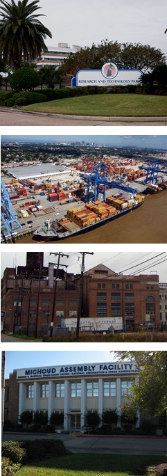
The Centers for Industry Districts contain an intensive mix of primarily non-residential uses. In most cases, the dominant character of these areas is that they are land extensive uses, such as office or industrial parks, industrial uses, and large research parks, both in campus developments and along designated corridors. Also, protection from encroachment of incompatible uses into the Centers for Industry Districts is key to preserve important city assets such as port-related uses and active industrial areas.
The Districts of the Centers for Industry contain regulations to create and maintain areas of major intensive employment and business operation destination environments. The Centers for Industry District can create significant impacts on surrounding uses, depending on the uses contained within, so proper site design, including auto storage and site circulation, landscape, and buffering, are key controls.
CHARACTER OF THE CENTERS FOR INDUSTRY
The character of the Centers for Industry is defined by:
» Concentrations of intensive employment and business operation destination environments, such as industrial development, research parks, and large office campuses
» Large development sites to accommodate parking, screening and buffering
» Protections from encroachment of incompatible uses by restricting uses to those of industry and supporting commercial
» Preservation of land best suited for high intensity uses, such as heavy industrial and maritime industrial uses
16.1 Purpose Statements
16.1.A Purpose of the LI Light Industrial District
The LI Light Industrial District is intended to provide for a wide variety of light manufacturing, fabricating, processing, wholesale distributing and warehousing uses appropriately located near or adjacent to major thoroughfares or railroads for access. Commercial uses and open storage of materials are permitted. Light industrial uses are typically low-intensity, non-nuisance light fabrication and assembly-type manufacturing, as well as office and research and development (R&D) facilities.
16.1.B Purpose of the HI Heavy Industrial District
The HI Heavy Industrial District is intended to provide for industrial operations of all types with the appropriate design and development standards to assure protection of the public interest and surrounding property and persons. Heavy industrial uses are higher intensity manufacturing, warehouse, and storage uses. These manufacturing uses may produce moderate external effects such as smoke, noise, glare, or vibration.
16.1.C Purpose of the MI Maritime Industrial District
The MI Maritime Industrial District is intended to provide for water-related and maritime shipping-related industrial operations, in particular port operations. The MI District protects deepwater resources by limiting the types of industrial users allowed within the district. In addition, limited marine-oriented commercial and recreational uses are allowed within a sub-district of the MI District, subject to special design standards.
16.1.D Purpose of the BIP Business-Industrial Park District
The BIP Business-Industrial Park District is intended to provide appropriate locations for certain types of business and light industrial facilities in well-designed and landscaped campus environments, and provide employment opportunities near residential areas. Supporting commercial uses are permitted, primarily for service to employees in the district. Typical development in the district would be that which is commonly known as an office and industrial park.
16.2 Uses
Only those uses of land listed under Table 16-1: Permitted and Conditional Uses as permitted uses or conditional uses are allowed within the Centers for Industry. A “P” indicates that a use is permitted within that zoning district. A “C” indicates that a use is a conditional use in that zoning district and would require a conditional use approval as required in Section 4.3 (Conditional Use). No letter (i.e., a blank space) or the absence of the use from the table indicates that use is not permitted within that zoning district. Section 16.4 provides additional permitted uses within the MI Maritime Industrial District Commercial and Recreational Sub-District, which are subject to additional design standards.
Table 16-1: Permitted and Conditional Uses
| Table 16-1: Permitted and Conditional Uses |
|
USE1
|
DISTRICTS
|
USE STANDARDS
|
|
LI
|
HI
|
MI2
|
BIP
|
|
RESIDENTIAL USE
|
|
Dwelling, Caretaker
|
P
|
P
|
P
|
P
|
|
|
Existing Residential
|
P
|
|
|
|
|
|
COMMERCIAL USE
|
|
Adult Use
|
C
|
C
|
|
|
Section 20.3.B
|
| Amusement Facility, Indoor |
|
|
|
P |
Section 20.3.E |
|
Auditorium
|
|
|
|
P
|
|
|
Bar
|
P
|
P
|
P
|
P
|
Section 20.3.G
|
|
Catering Kitchens
|
P
|
P
|
P
|
P
|
|
| Child Care Center, Small |
C |
C |
|
P |
Section 20.3.S |
| Child Care Center, Large |
C |
C |
|
P |
Section 20.3.S |
|
Day Care Center, Adult - Small
|
C
|
C
|
|
P
|
Section 20.3.S
|
|
Day Care Center, Adult – Large
|
C
|
C
|
|
P
|
Section 20.3.S
|
|
Day Care Center, Adult or Child – Commercial
|
C
|
C
|
|
P
|
Section 20.3.S
|
|
Drive-Through Facility
|
C
|
C
|
|
C
|
Section 20.3.V
|
|
Employment Services
|
P
|
P
|
P
|
P
|
Section 20.3.BB
|
|
Financial Institution
|
P
|
P
|
|
P
|
|
|
Gas Station
|
P
|
P
|
P
|
P
|
Section 20.3.EE
|
|
Greenhouse/Nursery
|
P
|
|
|
|
|
| Grocery Store |
P |
P |
P |
P |
|
|
Heavy Sales, Rental & Service
|
P
|
P
|
C
|
|
|
|
Hostel
|
|
|
|
P
|
|
|
Hotel/Motel
|
P
|
C
|
P
|
P
|
|
|
Kennel
|
P
|
P
|
|
|
Section 20.3.II
|
|
Micro-Brewery
|
P
|
P
|
|
P
|
|
|
Micro-Distillery
|
P
|
P
|
|
P
|
|
|
Motor Vehicle Service & Repair, Minor
|
P
|
P
|
|
|
Section 20.3.MM
|
|
Motor Vehicle Service & Repair, Major
|
P
|
P
|
|
|
Section 20.3.MM
|
|
Office
|
P
|
P
|
P
|
P
|
|
| Outdoor Live Entertainment - Secondary Use |
C |
C |
C |
C |
Section 20.3.WWW |
|
Passenger Terminal
|
P
|
P
|
P
|
P
|
|
|
Personal Service Establishment
|
|
|
|
P
|
|
|
Printing Establishment
|
P
|
|
|
P
|
|
| Reception Facility |
P |
|
|
|
Section 20.3.WW |
|
Recreational Vehicle Park
|
C
|
C
|
C
|
|
Section 20.3.XX
|
|
Restaurant, Carry-Out
|
P
|
P
|
P
|
P
|
Section 20.3.ZZ
|
|
Restaurant, Fast Food
|
|
|
|
P
|
Section 20.3.ZZ
|
|
Restaurant, Standard
|
P
|
P
|
P
|
P
|
Section 20.3.ZZ
|
|
Restaurant, Specialty
|
P
|
P
|
P
|
P
|
Section 20.3.ZZ
|
|
Retail Goods Establishment
|
P
|
P
|
P
|
P
|
|
|
Retail Sales of Packaged Alcoholic Beverages
|
P
|
P
|
P
|
C
|
|
| Shooting Range, Indoor |
C |
C |
|
|
Section 20.3.RRR |
| Shooting Range, Outdoor |
C |
C |
|
|
Section 20.3.RRR |
| Short Term Rental, Commercial |
P |
C |
C6 |
P |
Section 20.3.LLL |
| Small Box Variety Store |
P |
P |
P |
P |
Section 203.3.NNN |
|
Social Club or Lodge
|
C
|
C
|
C
|
C
|
Section 20.3.CCC
|
| Winery |
P |
P |
|
P |
|
|
INDUSTRIAL USE
|
|
Airport
|
|
|
C
|
|
Section 20.3.D
|
|
Batching Plant (Asphalt, Cement or Concrete)
|
C
|
C
|
|
|
|
|
Brewery
|
P
|
P
|
|
P
|
|
|
Broadcasting Studio
|
P
|
P
|
|
P
|
|
|
Composting Facility, Industrial
|
C
|
C
|
|
|
Section 20.3.BBB
|
|
Construction and Demolition Debris Recycling Facility
|
C
|
C
|
|
|
Section 20.3.P
|
|
Contractor Storage Yard
|
P
|
P
|
|
|
Section 20.3.Q
|
| Convenience Center |
P |
P |
P |
P |
Section 20.3.TTT |
| Distillery |
P |
P |
|
P |
|
| District Energy System |
P |
P |
P |
|
Section 20.3.QQQ |
|
Dry Dock and Launching Operations
|
|
|
P
|
|
|
|
Food Processing
|
P
|
P
|
P
|
P5
|
|
|
Freight Terminal
|
P
|
P
|
P
|
|
|
|
Heliport
|
P
|
P
|
C
|
C
|
Section 20.3.D
|
|
Helistop
|
P
|
P
|
C
|
C
|
Section 20.3.D
|
| Mardi Gras Den |
P |
P |
|
P |
|
|
Manufacturing, Artisan
|
P
|
P
|
|
|
|
|
Manufacturing, Light
|
P
|
P
|
P
|
P
|
|
|
Manufacturing, Heavy
|
|
P
|
P
|
|
|
|
Manufacturing, Maritime-Dependent
|
P
|
P
|
P
|
|
|
|
Marina, Commercial
|
P
|
P
|
P
|
|
|
|
Marine Terminal
|
P
|
P
|
P
|
|
|
|
Maritime Use
|
P
|
P
|
P
|
C
|
|
| Mini-Warehouse |
P |
P |
P |
P |
|
|
Mining & Drilling Activities
|
C
|
C
|
|
|
Section 20.3.KK
|
|
Motor Vehicle Operations Facility
|
P
|
P
|
|
C
|
|
|
Movie Studio
|
P
|
P
|
|
P
|
|
|
Outdoor Storage Yard
|
P
|
P
|
P
|
|
Section 20.3.Q
|
|
Railyard
|
P
|
P
|
P
|
P
|
|
|
Research & Development
|
P
|
P
|
P
|
P
|
|
|
Salvage Yard
|
C
|
C
|
|
|
Section 20.3.AAA
|
|
Separation/Recovery Facilities
|
C
|
C
|
|
|
Section 20.3.BBB
|
|
Shipyard
|
|
P
|
P
|
|
|
|
Solar Energy System
|
P
|
P
|
P
|
P
|
Section 20.3.DDD
|
|
Truck Repair
|
P
|
P
|
|
|
|
|
Truck Stop
|
C
|
C
|
|
|
Section 20.3.FFF
|
|
Truck Terminal
|
P
|
P
|
P
|
|
Section 20.3.FFF
|
|
Warehouse
|
P
|
P
|
P
|
P
|
|
|
Waste Transfer Station
|
C
|
C
|
|
|
Section 20.3.BBB
|
|
Water and Sewage Treatment Facilities
|
C
|
C
|
|
|
Section 20.3.HHH
|
|
Wholesale Goods Establishment
|
P
|
P
|
|
P
|
|
|
Wind Farm
|
P
|
P
|
P
|
P
|
Section 20.3.III
|
|
INSTITUTIONAL USE
|
| City Hall |
C |
C |
C |
C |
|
|
Educational Facility, Vocational
|
C
|
C
|
P
|
C
|
Section 20.3.Z
|
|
Educational Facility, University
|
C
|
C
|
P
|
C
|
|
|
Emergency Shelter
|
C
|
|
|
|
Section 20.3.AA
|
|
Government Offices
|
P
|
P
|
P
|
P
|
|
|
Public Works and Safety Facility
|
P
|
P
|
P
|
P
|
|
|
Prison
|
C
|
C
|
|
|
|
|
Social Club or Lodge
|
C
|
|
C
|
P
|
Section 20.3.CCC
|
| OPEN SPACE USE |
| Stormwater Management (Principal Use) |
P |
P |
P |
P |
|
|
OTHER
|
| EV Charging Station (Principal Use) |
P |
P |
P |
P |
Section 20.3.YYY |
| Parking Lot (Accessory Use) |
P7 |
P7 |
P7 |
P7 |
|
|
Parking Lot (Principal Use)
|
P
|
P
|
P
|
P
|
Section 20.3.OO
|
|
Parking Structure (Principal Use)
|
P
|
P
|
P
|
P
|
Section 20.3.OO
|
|
Planned Development
|
C
|
C
|
C
|
C
|
Article 5
|
|
Pumping Station
|
P
|
P
|
P
|
P
|
Section 20.3.UU
|
|
Utilities
|
P3
|
P3
|
P3
|
P3
|
Section 20.3.GGG
|
|
Wireless Telecommunications Antenna & Facility
|
C,P4
|
C,P4
|
C,P4
|
P4
|
Section 20.3.JJJ
|
|
Wireless Telecommunications Tower & Facility
|
P
|
P
|
P
|
P
|
Section 20.3.JJJ
|
TABLE 16-1 FOOTNOTES
1 The terms in this column (“Use”) are defined in Article 26.
2 Subject to uses and design standards in Section 16.4.
3 Electrical Utility Substations and Transmission Lines shall be subject to design review as per Article 4, Section 4.5.B.5 and Table 4-2
4 Only wireless telecommunications antennas that comply with the stealth design standards of Section 20.3.JJJ are considered permitted uses.
5 Food processing facilities are only permitted in BIP districts located in Planning District 9 and 10.
6 Commercial Short Term Rentals are only permitted in the Commercial and Recreational Sub-District in accordance with Section 16.4.B.
7As authorized in Article 22, Section 22.8.B.2.a
Adopted by August 19, 2016, Zoning Docket 060-16, Ord. 27,027 MCS; November 9, 2016, Zoning Docket 083-16, Ord. 27,167 MCS, §1; February 17, 2017, Zoning Docket 111-16, Ord. 27,272 MCS, §1; Ord. No. 27,762, §2, May 11, 2018, Zoning Docket 23/18; Ord. No. 27,707, §1, April 2, 2018, Zoning Docket 001/18; Ord. 28176, Sept. 5, 2019, ZD 59/19; Ord No 28,156 MCS, §10, August 8, 2019, Zoning Docket 26/19 & 27/19; Ord. 28,322 MCS, §3, February 28, 2020, Zoning Docket 117-19; Ord. 28432 MCS, 8-6-20, ZD 38/20; Ord. 28696 MCS, 6-3-21, ZD 16/21; Ord. 28736 MCS, ZD 17/21; Ord 28905, 1-6-22, ZD 83/21; Ord 28967 MCS, 3-10-22, ZD 107/21; Ord. 29126, 8-12-22, ZD016/22; Ord 29157 MCS, 9-12-22, ZD 030/22; Ord. 29528, 7-24-23, Zoning Docket 13/23
16.3 Bulk and Yard Regulations
16.3.A Site Design Standards
16.3.A.1 General Regulations
Table 16-2: Bulk and Yard Regulations establishes bulk and yard regulations for the Centers of Industry Districts.
Table 16-2: Bulk & Yard Regulations
| Table 16-2: Bulk & Yard Regulations |
|
BULK & YARD REGULATIONS
|
DISTRICTS
|
|
LI
|
HI
|
MI
|
BIP
|
|
BULK REGULATIONS
|
|
|
MINIMUM
LOT AREA
|
5,000sf
|
10,000sf
|
10,000sf
|
5,000sf
|
|
A
|
MAXIMUM BUILDING HEIGHT
|
75’, unless adjacent to a residential district then 50’ but may exceed 50’ if set back 1’ for each foot above 50’ up to 75’
|
None, unless adjacent to a residential district then 50’ - may exceed 50’ if set back 1’ for each foot above 50’
|
None, unless adjacent to a residential district then 50’ - may exceed 50’ if set back 1’ for each foot above 50’
|
75’, unless adjacent to a residential district then 50’ but may exceed 50’ if set back 1’ for each foot above 50’ up to 75’
|
| |
MINIMUM PERMEABLE OPEN SPACE |
20% of the lot area |
20% of the lot area |
20% of the lot area |
20% of the lot area |
|
MINIMUM YARD REQUIREMENTS
|
|
B
|
FRONT YARD
|
Section 16.3.A.2
|
Section 16.3.A.2
|
Section 16.3.A.2
|
Section 16.3.A.2
|
|
C
|
INTERIOR
SIDE YARD
|
15’
|
20’
|
20’
|
None, unless lot abuts residential district then 10’
|
|
D
|
CORNER
SIDE YARD
|
10’
|
20’
|
20’
|
None
|
|
E
|
REAR YARD
|
None, unless abutting residential district, then 20’
|
None, unless abutting a residential district, then 20’
|
20’, unless rear yard abuts a waterway, then none required
|
None, unless lot abuts residential district then 20’
|
TABLE 16-2 FOOTNOTES
1 If a property abuts more than one zoning district, the more restrictive yard requirement applies.

Adopted by Ord. No. 26,726, §1, December 7, 2015, Zoning Docket 081/15; Ord. No. 27,722, §7, April 11, 2018, Zoning Docket 113/17
16.3.A.2 Front Yard Build-To Line Requirement
a. Within the Centers for Industry Districts, the front yard build-to line is established by any one (1) of the following methods. A build-to line is an established setback line at which a structure is required to build. However, in no case may the front yard exceed twenty (20) feet.
i. As of the effective date of this Ordinance, the current front yard of the existing structure may be set as the required front yard build-to line. When a structure is demolished, the demolition permit shall indicate the dimension of the front yard prior to demolition. The required front yard build-to line is that indicated on the demolition permit.
ii. The required front yard build-to line indicated on the most recent survey or Sanborn maps.
iii. The average of the front yard of the adjacent lots on either side may be used to establish the required front yard build-to line. Averaging is based on the two (2) adjacent lots or, in the case of a corner lot, two (2) neighboring lots on the same blockface. In the case of a lot configuration where only one (1) lot is available for averaging, the front yard build-to line is that of the adjacent lot. (See Figure 16-1: Front Yard Averaging)
b. The applicant is permitted a plus or minus three (3) foot variation from a front yard build-to line established by any of the above methods.
c. The required front yard build-to line is measured as the narrowest dimension from the front lot line to the principal structure. The measurement is taken from the building walls of the principal structure and does not include permitted encroachments or architectural features.
FIGURE 16-1: FRONT YARD AVERAGING

16.3.B Building Design Standards
1. The following standards shall apply to all sites except those buildings or portions thereof that are not visible from the public right-of-way.
a. Nearly vertical roofs (A-frames) and piecemeal mansard roofs used on a portion of the building perimeter are prohibited.
b. Reflective roof materials that produce glare are prohibited.
2. The following standards shall apply to all sites that meet the applicability thresholds of Section 4.5 Development Plan and Design Review:
a. Buildings shall use decorative roof elements, such as projecting cornices, to define building entrances, main pedestrian routes, or activity areas.
b. Green roof, blue roof, and white roof designs are encouraged.
c. In the LI and BIP Districts, multi-building complexes shall develop a comprehensive architectural concept within a campus-like design. Various site components shall be unified through the use of similar design features, construction, material, and colors. Buildings within such complexes shall be compatible in height and scale.
d. The design of accessory structures, such as security kiosks, maintenance buildings, and outdoor equipment enclosures, shall be incorporated into and compatible in design with the overall design of the project and the principal buildings on the site.
16.3.B.3 Building Materials
a. The following materials are prohibited as the predominant surface finish material on exterior elevations visible from the public right-of-way. However, such materials may be used as part of decorative or detail elements, or as part of the exterior construction that is not used as a predominant surface finish material.
i. EIFS panels
ii. Stuccato Board
iii. Vinyl
16.4 MI District Commercial and Recreational Sub-District
16.4.A Applicability
The regulations within this section apply to the following sub-district within the MI District: All properties in the area bounded by Chef Menteur Highway, Lake Shore Drive, France Road and the projection of its centerline, and Jourdan Road and the projection of its centerline.
16.4.B Uses
The following uses are allowed as permitted uses within this sub-district, subject to the design standards of Paragraph C below:
1. Boat launch
2. Commercial marinas
3. Recreational marinas
4. Recreational vehicle park
5. Short term rentals, Commercial
6. Timeshare
*Regulations effective April 1, 2017 (Ord. No. 27,209, §2)
Adopted by Ord. No. 27,209, §1, Dec. 7, 2016, Zoning Docket 61/16
16.4.C Sub-District Design Standards
The following design standards apply to all uses listed in Paragraph B above within the MI District Sub-District. (See Figure 16-2: Waterfront Development)
1. All structures shall comply with the building design standards of Paragraph B above, with the exception that main building entrances may be oriented to the waterfront or to an access drive. However, any main building entrance oriented to the waterfront or to an access drive shall be approved by the New Orleans Police Department, the New Orleans Fire Department, and the New Orleans Emergency Medical Services in order to ensure adequate access for public safety vehicles and equipment in the event of an emergency.
2. The façade articulation and visual reduction of mass and scale requirements of Paragraph B above also apply to any building façade that is visible from a body of water.
3. Where such a use is located on a site with frontage along a body of water, a minimum of thirty percent (30%) of the water frontage of the site on which the use is located shall be maintained as open space for a minimum depth of twenty (20) feet from the water’s edge. Such open space shall be landscaped in accordance with the provisions of Article 23. Pedestrian access shall be provided within such open space through the provision of a walkway with an unobstructed view of the water.
4. With the exception of spaces designated for the accommodation of recreational vehicles at a recreational vehicle park, no off-street vehicle parking spaces, aisles, driveways, or other access drives for parking are permitted within twenty (20) feet of any frontage along a body of water. All areas located between any off-street vehicle parking area and any frontage along a body of water shall be occupied by a main building, an accessory building, a boat launch, an access drive for a boat launch, or landscape that meets the requirements of Article 23.
FIGURE 16-2: WATERFRONT DEVELOPMENT

16.5 General Standards of Applicability
All Centers for Industry Districts are subject to the following standards:
16.5.A Accessory Structures and Uses
See Section 21.6 for standards governing accessory structures and uses.
16.5.B Temporary Uses
See Section 21.8 for standards governing temporary uses.
16.5.C Site Development Standards
See Article 21 for additional site development standards such as exterior lighting, environmental performance standards, and permitted encroachments.
16.5.D Off-Street Parking and Loading
See Article 22 for standards governing off-street parking and loading.
16.5.E Landscape, Stormwater Management, and Screening
See Article 23 for standards governing landscape, stormwater management, and screening.
16.5.F Signs
See Article 24 for standards governing signs.
16.5.G Overlay Districts
See Article 18 for additional overlay district regulations, when applicable.
16.5.H Nonconformities
See Article 25 for regulations governing nonconformities.
Article 17
Central Business Districts
PURPOSE OF THE CENTRAL BUSINESS DISTRICTS
 New Orleans’ Central Business Districts are characterized by a wide diversity of uses functioning within a single geography. These uses are mixed horizontally and vertically in a series of buildings, arranged along a continuous streetwall. The Central Business Districts are designed to serve a diversity of functions within this same compact geography, including the community's civic center, a regional employment center, an international visitor center, and centers of service and learning.
The zoning districts of the Central Business Districts contain regulations that create and maintain a focused destination that mixes employment, shopping, residential and entertainment activities in an intense, high density, primarily pedestrian environment.
CHARACTER OF THE CENTRAL BUSINESS DISTRICTS
The character of the Central Business Districts is defined by:
» The highest intensity development within the City, including office and residential high-rises
» High-intensity office and employment growth centers
» A pedestrian environment with active uses such as retail and restaurants along the street
» Large-scale entertainment uses, such as the Superdome and Convention Center
» Cultural and entertainment destinations, including museums, theaters, and music venues
» Historic structures and districts that preserve the Central Business Districts' heritage and provide opportunities for adaptive reuse and mixed-use development
» Urban core neighborhoods with a variety of housing types mixed in with supporting business and commercial uses
17.1 Article Structure
To determine which regulations apply to an area within the CBD Districts, the user should follow the steps shown in the flowchart of this Article. (See Figure 17-1: Guide to Article Structure)
FIGURE 17-1: GUIDE TO ARTICLE STRUCTURE

17.2 Purpose Statements
17.2.A CBD-1 Core Central Business District
The CBD-1 Core Central Business District is intended for high-density, mixed-use development that accommodates a wide range of uses, including large office, financial, and commercial services uses that serve the local, regional, and national markets, as well as multi-family housing, retail, entertainment, hotel, government, and institutional uses.
17.2.B CBD-2 Historic Commercial and Mixed-Use District
The CBD-2 Historic Commercial and Mixed-Use District is intended to provide for the reuse of existing structures in historic districts and along prominent mixed-use corridors that frame the Central Business District. Buildings in the CBD-2 District provide small floor plates for office, retail, institutional, and residential uses that support the vitality of the Central Business District as a destination for residents and visitors. The CBD-2 District addresses unique corridors and historic districts within the Central Business District, including Convention Center Boulevard, the Picayune Place Historic District, and the central portion of Canal Street.
17.2.C CBD-3 Cultural Arts District
The CBD-3 Cultural Arts District is intended to create a cultural and entertainment destination through the clustering of museum, cultural, performing arts, and supporting visitor services uses. The CBD-3 District is also intended to accommodate a mixture of residential, retail, and other commercial uses for residents and visitors. The CBD-3 District is specifically intended to address the music and theater corridor along and adjacent to the intersection of Basin, Rampart, and Canal Streets, and theaters and museum uses along Magazine Street and Howard Avenue.
17.2.D CBD-4 Exposition District
The CBD-4 Exposition District is intended for large destination uses and related services which generate high volumes of visitor traffic. The CBD-4 District addresses unique large-scale uses like the Superdome, Arena, and Convention Center.
17.2.E CBD-5 Urban Core Neighborhood Lower Intensity Mixed-Use District
The CBD-5 Urban Core Neighborhood Lower Intensity Mixed-Use District is intended to provide for a downtown neighborhood environment through a mix of housing types and supporting residential services and commercial uses conveniently situated with respect to employment opportunities. The CBD-5 District is intended to accommodate a lower concentration of certain commercial uses than the CBD-6 District, and is particularly suited for the area around Lafayette Square and surrounding areas.
17.2.F CBD-6 Urban Core Neighborhood Mixed-Use District
The CBD-6 Urban Core Neighborhood Intensity Mixed-Use District is intended to provide for a downtown neighborhood environment with a mix of housing types, supporting residential services and commercial uses conveniently situated with respect to employment opportunities. The CBD-6 District is intended to accommodate a higher concentration of certain commercial uses than the CBD-5 District, and is particularly suited for the Warehouse District.
17.2.G CBD-7 Bio-Science District
The CBD-7 Bio-Science District is intended for large-scale bio-science campuses and supportive services. Standards for the CBD-7 District address the unique development of a large campus and its supportive services in order to create proper transitions from the campus to adjacent uses, as well as specific regulations for the core of the district.
17.2.H Purpose of the Central Business Districts Mandatory Inclusionary Zoning Sub-Districts
The Central Business Districts Mandatory Inclusionary Zoning Sub-Districts are intended to include mandatory affordable housing requirements, in accordance with Article 28, in districts that allow the development of ten or more dwelling units.
17.3 Uses
17.3.A Permitted and Conditional Uses
Only those uses of land listed under Table 17-1: Permitted and Conditional Uses as permitted uses or conditional uses are allowed within the Central Business Districts. A “P” indicates that a use is permitted within that zoning district. A “C” indicates that a use is a conditional use in that zoning district and would require a conditional use approval as required in Section 4.3 (Conditional Use). No letter (i.e., a blank space) or the absence of the use from the table indicates that use is not permitted within that zoning district.
Table 17-1: Permitted and Conditional Uses
| Table 17-1: Permitted and Conditional Uses |
|
USE1
|
DISTRICTS
|
USE STANDARDS
|
|
CBD-1
|
CBD-2
|
CBD-3
|
CBD-4
|
CBD-5
|
CBD-6
|
CBD-7
|
|
RESIDENTIAL USE
|
|
Bed and Breakfast – Accessory
|
C
|
C
|
C
|
|
C
|
C
|
|
Section 20.3.I
|
|
Bed and Breakfast – Principal
|
C
|
C
|
C
|
|
C
|
C
|
|
Section 20.3.I
|
|
Home Based Child Care, Small
|
|
|
|
|
P
|
P
|
P
|
Section 20.3.T
|
|
Home Based Child Care, Large
|
|
|
|
|
P
|
P
|
P
|
Section 20.3.T
|
|
Dormitory
|
P
|
P
|
|
|
|
|
P
|
|
|
Dwelling, Above the Ground Floor
|
P
|
P
|
P
|
|
P
|
P
|
P
|
|
|
Dwelling, Single-Family
|
|
|
|
|
P
|
P
|
|
|
|
Dwelling, Two-Family
|
|
|
|
|
P
|
P
|
|
Section 20.3.Y
|
|
Dwelling, Townhouse
|
|
|
|
|
P
|
P
|
|
|
|
Dwelling, Multi-Family
|
P
|
P
|
P
|
P
|
P
|
P
|
P
|
|
|
Group Home, Small
|
P
|
P
|
P
|
|
P
|
P
|
P
|
Section 20.3.GG
|
|
Group Home, Large
|
P
|
P
|
P
|
|
P
|
P
|
P
|
Section 20.3.GG
|
|
Group Home, Congregate
|
P
|
P
|
P
|
|
P
|
P
|
P
|
Section 20.3.GG
|
|
Permanent Supportive Housing
|
P
|
P
|
P
|
|
P
|
P
|
P
|
Section 20.3.PP
|
|
Residential Care Facility
|
P
|
P
|
P
|
|
P
|
P
|
P
|
Section 20.3.YY
|
|
Timeshare
|
P
|
P
|
P
|
P
|
|
|
P
|
|
|
COMMERCIAL USE
|
|
Amusement Facility, Indoor
|
P
|
P
|
P
|
P
|
C
|
C
|
C
|
Section 20.3.E
|
|
Amusement Facility, Outdoor
|
|
|
|
P
|
|
|
|
Section 20.3.E
|
|
Arena
|
|
|
|
C
|
|
|
|
|
|
Art Gallery
|
P
|
P
|
P
|
P
|
P
|
P
|
P
|
|
|
Arts Studio
|
P
|
P
|
P
|
P
|
P
|
P
|
P
|
|
|
Auditorium
|
|
|
|
P
|
|
|
P
|
|
|
Bar
|
C
|
C
|
C
|
P
|
|
C
|
C
|
Section 20.3.G
|
|
Broadcasting Studio
|
P
|
P
|
P
|
P
|
P
|
|
|
|
|
Bus Terminal
|
|
|
|
C
|
|
|
|
|
|
Casino/Gaming Establishment
|
|
|
|
C
|
|
|
|
Section 20.3.M
|
|
Catering Kitchen
|
P
|
P
|
P
|
P
|
P
|
P
|
P
|
|
| Child Care Center, Small |
P |
P |
P |
P |
P |
P |
P |
Section 20.3.S |
| Child Care Center, Large |
P |
P |
P |
P |
P |
P |
P |
Section 20.3.S |
|
Convention Center
|
|
|
|
C
|
|
|
|
|
|
Day Care Center, Adult – Small
|
P
|
P
|
P
|
P
|
P
|
P
|
P
|
Section 20.3.S
|
|
Day Care Center, Adult – Large
|
P
|
P
|
P
|
P
|
P
|
P
|
P
|
Section 20.3.S
|
|
Day Care Center, Adult - Commercial
|
P
|
P
|
P
|
P
|
P
|
P
|
P
|
Section 20.3.S
|
|
Employment Services
|
C
|
|
|
|
|
|
C
|
Section 20.3.BB
|
|
Financial Institution
|
P
|
P
|
P
|
P
|
P
|
P
|
P
|
|
|
Gas Station
|
|
|
|
C
|
|
|
|
Section 20.3.EE
|
| Grocery Store |
P |
P |
P |
P |
P |
P |
P |
|
|
Health Club
|
P
|
P
|
P
|
P
|
P
|
P
|
P
|
|
|
Hostel
|
P
|
P
|
P
|
P
|
|
|
P
|
|
|
Hotel/Motel
|
P
|
P
|
P
|
P
|
C
|
P
|
P
|
Section 20.3.XXX
|
|
Live Entertainment – Secondary Use
|
P
|
P6
|
P
|
P
|
C
|
C
|
P6
|
Section 20.3.JJ
|
|
Live Performance Venue
|
C
|
C
|
C
|
P
|
C
|
C
|
|
Section 20.3.JJ
|
| Motor Vehicle Dealership, Large |
|
|
|
C |
|
|
C |
Section 20.3.LL |
| Motor Vehicle Dealership, Small |
|
|
|
C |
|
|
C |
Section 20.3.LL |
|
Motor Vehicle Rental Establishment
|
C
|
|
|
C
|
|
|
C
|
Section 20.3.LL
|
|
Medical/Dental Clinic
|
P
|
P
|
P
|
P
|
P
|
P
|
P
|
|
|
Micro-Breweries
|
|
P
|
|
|
|
|
P
|
|
|
Micro-Distilleries
|
|
P
|
|
|
|
|
P
|
|
|
Off-Track Betting Facility
|
|
|
|
C
|
|
|
|
|
|
Office
|
P
|
P
|
P
|
P
|
P
|
P
|
P
|
|
|
Outdoor Amphitheater
|
|
|
|
C
|
|
|
|
Section 20.3.VVV
|
| Outdoor Live Entertainment - Secondary Use |
C |
C |
C |
C |
C |
C |
C |
Section 20.3.WWW |
|
Personal Service Establishment
|
P
|
P
|
P
|
P
|
P
|
P
|
P
|
|
|
Public Market
|
C
|
C
|
C
|
C
|
P
|
P
|
C
|
Section 20.3.TT
|
|
Recording Studio
|
P
|
P
|
P
|
P
|
|
|
|
|
|
Reception Facility
|
P
|
P
|
P
|
P
|
C
|
P
|
P
|
Section 20.3.WW
|
|
Restaurant, Standard
|
P
|
P
|
P
|
P
|
P2
|
P
|
P
|
Section 20.3.ZZ
|
|
Restaurant, Specialty
|
P
|
P
|
P
|
P
|
P2
|
P
|
P
|
Section 20.3.ZZ
|
|
Restaurant, Fast Food
|
C
|
C
|
|
C
|
C2
|
C
|
C
|
Section 20.3.ZZ
|
|
Restaurant, Carry-Out
|
P
|
P
|
P
|
P
|
P2
|
P
|
P
|
Section 20.3.ZZ
|
|
Retail Goods Establishment
|
P
|
P
|
P
|
P
|
P
|
P
|
P
|
|
|
Retail Sales of Packaged Alcoholic Beverages
|
C
|
C
|
C
|
C
|
C
|
C
|
C
|
|
| Short Term Rental, Commercial |
P |
P |
P |
P |
P |
P |
P |
Section 20.3.LLL |
| Small Box Variety Store |
C |
C |
C |
C |
C |
C |
C |
Section 20.3.NNN |
|
Social Club or Lodge
|
P
|
P
|
P
|
P
|
C
|
C
|
P
|
Section 20.3. CCC
|
|
Stadium
|
|
|
|
C
|
|
|
|
|
| Winery |
|
P |
|
|
|
|
P |
|
|
INDUSTRIAL USE
|
|
Brewery
|
|
P5
|
|
|
|
|
P5
|
|
| Distillery |
|
P5 |
|
|
|
|
P5 |
|
| District Energy System |
C |
C |
C |
P |
|
|
P |
Section 20.3.QQQ |
|
Manufacturing, Artisan
|
|
C
|
|
|
|
|
C
|
|
|
Manufacturing, Light
|
|
C
|
|
|
|
|
C
|
|
| Mini-Warehouse |
|
|
|
|
|
P |
|
|
|
Motor Vehicle Operations Facility
|
|
|
|
|
|
|
P
|
|
|
Helistop
|
C
|
|
|
C
|
|
|
C
|
Section 20.3.D
|
|
Printing Establishment
|
P
|
P
|
P
|
P
|
C
|
C
|
|
|
|
Research & Development
|
P
|
P
|
|
|
|
|
P
|
|
|
INSTITUTIONAL USE
|
| City Hall |
C |
C |
C |
C |
C |
C |
C |
|
|
Community Center
|
P
|
P
|
P
|
P
|
P
|
P
|
|
|
|
Convent and Monastery
|
P
|
P
|
P
|
P
|
P
|
P
|
P
|
|
|
Cultural Facility
|
P
|
P
|
P
|
P
|
P
|
P
|
|
Section 20.3.R
|
|
Domestic Protection Shelter
|
P
|
P
|
P
|
P
|
P
|
P
|
P
|
Section 20.3.U
|
|
Educational Facility, Primary
|
P
|
P
|
P
|
|
P
|
P
|
P
|
Section 20.3.Z
|
|
Educational Facility, Secondary
|
P
|
P
|
P
|
|
P
|
P
|
P
|
Section 20.3.Z
|
|
Educational Facility, University
|
P
|
P
|
P
|
P
|
P
|
P
|
P
|
|
|
Educational Facility, Vocational
|
P
|
P
|
P
|
P
|
P
|
P
|
P
|
Section 20.3.Z
|
|
Emergency Shelter
|
P
|
P
|
P
|
P
|
P
|
P
|
C
|
Section 20.3.AA
|
|
Government Offices
|
P
|
P
|
P
|
P
|
P
|
P
|
P
|
|
|
Hospital
|
|
|
|
|
|
|
P
|
|
|
Place of Worship
|
P
|
P
|
P
|
P
|
P
|
P
|
P
|
|
|
OPEN SPACE USE
|
|
Parks and Playgrounds
|
P
|
P
|
P
|
P
|
P
|
P
|
P
|
|
|
Stormwater Management
(Principal Use)
|
P
|
P
|
P
|
P
|
P
|
P
|
P
|
|
|
OTHER
|
| Parking Lot (Accessory Structure) |
P7 |
P7 |
P7 |
P7 |
P7 |
P7 |
P7 |
|
|
Parking Structure (Principal Use)
|
P
|
P
|
P
|
P
|
P
|
P
|
P
|
Section 20.3.OO
|
| Planned Development |
C |
C |
C |
C |
C |
C |
C |
Article 5 |
|
Public Transit Wait Station
|
P
|
P
|
P
|
P
|
P
|
P
|
P
|
Section 21.6.BB
|
|
Pumping Station
|
P
|
P
|
P
|
P
|
P
|
P
|
P
|
Section 20.3.UU
|
|
Utilities
|
P3
|
P3
|
P3
|
P3
|
P3
|
P3
|
P3
|
Section 20.3.GGG
|
|
Wireless Telecommunications Antenna & Facility
|
C,P4
|
C,P4
|
C,P4
|
C,P4
|
C,P4
|
P4
|
C,P4
|
Section 20.3.JJJ
|
|
Wireless Telecommunications Tower & Facility
|
C
|
C
|
C
|
C
|
C
|
C
|
C
|
Section 20.3.JJJ
|
TABLE 17-1 FOOTNOTES
1 The terms in this column (“Use”) are defined in Article 26.
2 Subject to the use restriction in Section 17.3.B.4.
3 Electrical Utility Substations and Transmission Lines shall be subject to design review as per Article 4, Section 4.5.B.5 and Table 4-2
4 Only wireless telecommunications antennas that comply with the stealth design standards of Section 20.3.JJJ are considered permitted uses.
5 Subject to the use restrictions in Section 17.3.B.5.
6 Classified as a Conditional Use in Breweries.
7As authorized in Article 22, Section 22.8.B.2.a
Adopted by Ord. No. 27,209, §1, Dec. 7, 2016, Zoning Docket 61/16; Ord. No. 27,389, §1, May 8, 2017, Zoning Docket 22/17; Ord. No. 27,706, §1, April 2, 2018, Zoning Docket 94/17; Ord. 28036 MCS, Sec. 1, March 28, 2019, ZD 112/18; Ord. 28176, Sept. 5, 2019, ZD 59/19; Ord. 28219 MCS, Oct. 17, 2019, ZD 45/19; Ord No 28,156 MCS, §11, August 8, 2019, Zoning Docket 26/19 & 27/19; Ord. 28497 MCS, 9-17-20, ZD 52/20; Ord. 28,322 MCS, §4, February 28, 2020, Zoning Docket 117-19; Ord. 28432 MCS, 8-6-20, ZD 38/20; Ord. 28696 MCS, 6-3-21, ZD 16/21; Ord. 28737 MCS, 7-15-21, ZD 28/21; Ord 28905 MCS, 1-6-22, ZD 83/21; Ord. 29126, 8-12-22, ZD016/22; Ord 29157 MCS, 9-12-22, ZD 030/22; Ord. 29284 MCS, 1-5-23, ZD 63/22; Ord. 29636, 9-13-23, Zoning Docket 46-23; Ordinance No. 29702, November 7, 2023, Zoning Docket 063/23
17.3.B Use Restrictions
17.3.B.1 Required Uses for Ground Floors of Structures with Frontage on Multi-Modal/Pedestrian Corridors
In all CBD Districts, on sites that have at least fifty (50) feet of frontage along a multi-modal pedestrian corridor as defined in Section 17.6, at least twenty-five percent (25%) of the floor area of the ground story of a structure shall be allocated for occupancy by a commercial use authorized in the district and/or the related ancillary uses for a hotel/motel (as provided in Article 26), and/or the amenity components of a multi-family residence. Only the net floor area of the uses not including corridors or other spaces used in common with other uses, is counted in determining the amount of floor area allocated. Single-family dwellings, two-family dwellings, educational facilities, ferry terminals, public transportation wait stations, and townhouses are exempt from this use restriction.
Adopted by Ord. 29126, 8-12-22, ZD016/22
17.3.B.2 Required Uses for Properties Abutting Canal Street
a. In all CBD Districts, where a lot abuts Canal Street, at least seventy percent (70%) of the Canal Street frontage of the ground floor of any structure on the lot shall be allocated for occupancy by one (1) or more commercial uses and/or multi-family amenity components. Such uses shall have a minimum depth of ten (10) feet from the wall of the structure that faces Canal Street. Only the frontage of those uses, not including corridors or other spaces used in common with other uses, is counted in determining the amount of frontage allocated.
b. For any hotel/motel located in a structure on a lot that abuts Canal Street in any CBD District, the lobby of the hotel/motel may count toward meeting one-half (1/2) of the seventy percent (70%) frontage requirement.
c. For the purpose of meeting these space requirements, space will qualify only if it is at street level and if it is directly accessible to the public from a sidewalk or other public pedestrian way.
d. The following uses are prohibited in properties that abut Canal Street in any CBD Districts:
i. Restaurant, Fast Food
a. Except when the unit has a primary entrance on a street intersecting Canal Street and that entrance is at least 100 feet from Canal Street, and no part of the Fast Food use has frontage along Canal Street.
ii. T-shirt shop
Adopted by Ord. 29126, 8-12-22, ZD016/22
17.3.B.3 Prohibited Uses on Multi-Modal/Pedestrian Corridors
The following uses are prohibited in properties that abut designated multi-modal/pedestrian corridors (See Section 17.6):
a. Gas station
b. Motor vehicle rental establishments with outdoor display areas (only those that are fully enclosed are permitted)
17.3.B.4 Spacing of Restaurants in CBD-5 District
One of the following uses is permitted per blockface within the CBD-5 District:
a. Restaurant, Standard
b. Restaurant, Specialty
c. Restaurant, Fast Food
d. Restaurant, Carry-Out
When the restaurant has frontage on more than one blockface, the restriction applies to the blockfaces where the use has public access.
Adopted by Ord. 29126, 8-12-22, ZD016/22
17.3.B.5 Breweries in the CBD-2 and CBD-7 Districts
In the CBD-2 and CBD-7 Districts, only breweries and distilleries that produce fewer than 12,500 barrels per year are considered permitted uses.
Adopted by Ord. 28696 MCS, 6-3-21, ZD 16/21
17.4 Site Design Standards
17.4.A Bulk and Yard Regulations
17.4.A.1 General Requirements
Table 17-2: Bulk and Yard Regulations establishes bulk and yard regulations for the Central Business District.
Table 17-2: Bulk and Yard Regulations
| Table 17-2: Bulk and Yard Regulations |
|
BULK AND YARD REGULATIONS
|
DISTRICTS
|
|
CBD-1
|
CBD-2
|
CBD-3
|
CBD-4
|
CBD-5
|
CBD-6
|
CBD-7
|
|
BULK REGULATIONS
|
|
MINIMUM LOT AREA
|
None
|
None
|
None
|
None
|
None
|
None
|
None
|
|
MINIMUM BUILDING HEIGHT
|
36’ & 3 stories
|
36’ & 3 stories
|
36’ & 3 stories
|
None
|
36’ & 3 stories
|
36’ & 3 stories
|
36’ & 3 stories
|
|
MAXIMUM BUILDING HEIGHT
|
See Figure 17-2 and Section 17.4.A.2
|
See Figure 17-2 and Section 17.4.A.2
|
See Figure 17-2 and Section 17.4.A.2
|
See Figure 17-2 and Section 17.4.A.2
|
See Figure 17-2and Section 17.4.A.2
|
See Figure 17-2 and Section 17.4.A.2
|
See Figure 17-2 and Section 17.4.A.2
|
|
MAXIMUM FLOOR AREA RATIO
|
See Figure 17-3; may be increased through bonus1
|
See Figure 17-3; may be increased through bonus 1
|
See Figure 17-3; may be increased through bonus 1
|
See Figure 17-3; may be increased through bonus 1
|
See Figure 17-3; may be increased through bonus 1
|
See Figure 17-3; may be increased through bonus 1
|
See Figure 17-3; may be increased through bonus 1
|
|
YARD REQUIREMENTS
|
|
FRONT YARD
|
None required, but a 5’ maximum
Larger front yard permitted by conditional use
|
None required, but a 5’ maximum
Larger front yard permitted by conditional use
|
None required, but a 5’ maximum
Larger front yard permitted by conditional use
|
None
|
None required, but a 5’ maximum
Larger front yard permitted by conditional use
|
None
|
None required, but a 5’ maximum
Larger front yard permitted by conditional use
|
|
MINIMUM INTERIOR SIDE YARD
|
None
|
None
|
None
|
None
|
None
|
None
|
None
|
|
MINIMUM CORNER SIDE YARD
|
None
|
None
|
None
|
None
|
None
|
None
|
None
|
|
MINIMUM REAR YARD
|
None
|
None
|
None
|
None
|
None
|
None
|
None
|
TABLE 17-2 FOOTNOTES
1 Public benefit FAR bonuses may enable developments to exceed the maximum base FAR indicated in Figure 17.3, in accordance with the provisions of Section 17.5. Bonuses are only available in the areas regulated by Floor Area Ratio. Bonuses are not available in the areas with maximum height established by Figure 17-2 and Section 17.4.A.2.
Table 17-3: The Mandatory Inclusionary Zoning Sub-District (MIZ) regulations establish mandatory inclusionary unit thresholds, set aside requirements, and Area Medium Income (AMI) levels and is required for any development that contains residential development of 10 or more dwelling units, including rental and homeownership dwelling units. Affordable Housing Units shall be in accordance with the standards outlined in the table below. All other bulk and yard regulations for the sub-districts are subject to the corresponding non-inclusionary zoning base district regulations.
|
Table 17-3: Central Business Inclusionary Zoning
Sub-District Regulations1, 2
|
|
Zoning Sub-District
|
Affordable Housing Unit Threshold
|
Set Aside Requirement
%
|
Area Medium Income Level (AMI) Rental Units (%)
|
Area Medium Income AMI Homeownership (%)
|
|
CBD-1-IZ
|
10
|
10
|
60
|
60
|
|
CBD-2-IZ
|
10
|
10
|
60
|
60
|
|
CBD-3-IZ
|
10
|
10
|
60
|
60
|
|
CBD-4-IZ
|
10
|
10
|
60
|
60
|
|
CBD-5-IZ
|
10
|
10
|
60
|
60
|
|
CBD-6-IZ
|
10
|
10
|
60
|
60
|
|
CBD-7-IZ
|
10
|
10
|
60
|
60
|
TABLE 17-3 FOOTNOTES
1The terms for the Mandatory Inclusionary Zoning Sub-Districts in this section are outlined in Article 28.
2These districts do not require a minimum lot area per dwelling unit.
Adopted by Ord. 28036 MCS, Sec. 1, March 28, 2019, ZD 112/18; Ord 28178, 9-5-19, ZD 49/19
17.4.A.2 Building Height
a. The maximum building height on a lot is indicated in Figure 17-2: Maximum Building Height. Those lots that are not subject to building height limits are subject to maximum floor area ratio (FAR) limits and are indicated in Figure 17-3: Maximum FAR.
b. Within those blocks bounded by Canal, Iberville, North Peters, and Crozat Streets, where a lot fronts on two (2) or more principal street frontages, each with a different maximum building height, the maximum building height for each street frontage applies for a distance of eighty-three (83) feet from the centerline of the street. (See Figure 17-4: Height Applicability to Street Frontage for Certain Blocks for illustration and Figure 17-5: Height Example for Certain Lots Along Canal Street for an example).
c. The height designation of “75/125 ft & 6/10 Stories” on Figure 17-2 is interpreted as follows: a height limit of six (6) stories and seventy-five (75) feet applies within twenty (20) feet of all property lines adjacent to any public right-of-way, and a height limit of ten (10) stories and one hundred twenty-five (125) feet applies to all other portions of the lot.
d. Where provided as accessory flat roof features, open spaces located on roofs shall be excluded from the calculation of building height in accordance with Section 21.6.
FIGURE 17-2: MAXIMUM BUILDING HEIGHT

FIGURE 17-3: MAXIMUM FLOOR AREA RATIO

FIGURE 17-4: HEIGHT APPLICABILITY TO STREET FRONTAGE IN CERTAIN BLOCKS

FIGURE 17-5: HEIGHT EXAMPLE FOR CERTAIN LOTS ALONG CANAL STREET

Adopted by Ord. 27,723 MCS, §1, April 11, 2018, Zoning Docket 106-17
17.4.B Required On-Site Open Space
All townhouse and multi-family dwellings in the CBD Districts shall provide at least one-hundred twenty (120) square feet of usable on-site open space per dwelling unit. Where individual balconies are authorized as open space for individual dwelling units, a minimum depth of four (4) feet shall be required. This open space may be either private open space for the dwelling unit or common open space restricted to the use of residents of the townhouse or multi-family dwelling. Such open space shall meet the following requirements:
1. Required open space shall have a minimum dimension of at least seven (7) feet on any side.
2. Required open space shall be located on the same lot as the dwelling unit it serves.
3. Required open space shall be built so as to make these spaces physically accessible for all residents of said townhouse or multi-family dwelling.
3. Required open space shall be outdoors and designed for outdoor living, recreation, or landscaping, including areas located on the ground and areas on decks, balconies, galleries, porches, or roofs. For multi-family dwellings, when open space is above grade, such as a balcony or gallery, it may not be located over on-site surface parking areas.
4. Required open space areas are is not required to be contiguous, but each open space area, whether common or private, shall comply with minimum dimensional standards of Table 17-2. Common open space areas shall be accessible to all residents of the townhouse or multi-family dwelling.
5. When located at ground level, the required open space area shall be substantially covered with grass, live groundcover, shrubs, plants, trees, or permeable outdoor hardscape features or amenities, such as seating areas, patios, or pools.
6. Off-street parking and loading areas, driveways or required landscaping for parking lots and screening do not count towards open space requirements. Bollards, curbs, wheel stops, or other similar features shall be provided to ensure that required open space areas are not used for off-street parking or any other vehicular use.
7. Mechanical equipment, dumpsters, or service areas are prohibited in required open space areas.
8. All required open space areas shall be located and designed to take advantage of sunlight and other climatic advantages of the site.
9. Where provided as accessory flat roof features, open spaces located on roofs shall be excluded from the calculation of gross floor area in accordance with Section 21.6.
Adopted by Ord. No. 27,722, §10, April 11, 2018, Zoning Docket 113/17
17.5 Public Benefit Floor Area Ratio (FAR) Bonus Provisions
17.5.A Administration
1. Any development in the CBD Districts that utilizes the public benefit FAR bonus provisions of this section requires development plan and design review and the approval by the Executive Director of the City Planning Commission, following a review by the Design Advisory Committee in accordance with Section 4.5.
2. The applicant shall file a bonus worksheet at the time of the submittal of a development plan and design review application that describes the size, location, design, and maintenance of the proposed public benefit amenity and the calculation for the amount of bonus floor area requested. If any bonus FAR is approved, the final worksheet shall be recorded, together with the final approved development plan, with the deed of the property for which it is granted in the office of the Clerk of Court for Orleans Parish Civil District Court, prior to the issuance of any building permit or certificate of occupancy for the development. The recorded approved final development plan and bonus worksheet shall be binding on the property owners, successors, and assigns for the life of the building to ensure compliance with this Ordinance for the design and maintenance of the public amenities. Within thirty (30) days of receiving evidence of the recording of an approved development plan and bonus worksheet, the Executive Director of the City Planning Commission shall designate the site for which the FAR bonus has been granted on the Official Zoning Map.
3. No public amenity for which a floor area bonus has been granted may be eliminated or reduced in size without a corresponding reduction in floor area or the substitution of an equivalent bonus. Any proposal for the substitution of an equivalent bonus shall only be considered and may only be approved in accordance with a new application for site plan and design review in accordance with the provisions of this section.
4. Floor area exceeding the maximum base floor area ratio added to a building by virtue of floor area ratio bonuses of this section may not, in turn, serve as a basis for creating additional bonuses.
17.5.B Applicability
The base maximum floor area ratio (FAR) in those areas of the CBD without height limits may be increased in accordance with following provisions. Features eligible for public benefit bonuses are the following:
1. Whole building sustainability (Paragraph C below)
2. Financial contributions to public park/open space improvements (Paragraph D below)
3. Financial contributions to landmark preservation (Paragraph E below)
4. Public plazas (Paragraph F below)
5. Transit-oriented development (Paragraph G below)
6. Affordable housing (Paragraph H below)
At least fifty percent (50%) of any density bonus applied to any project with a residential component must utilize the affordable housing bonus provisions described in section 17.H.
17.5.C Whole Building Sustainability
17.5.C.1 Whole Building Sustainability Public Benefit Formula
a. Provision of a recognized green building certification, such as LEED Gold level (Leadership in Energy & Environmental Design), Home Energy Rating System, Enterprise Green Communities, National Green Building Standard, Energy Star for Buildings Program, Net-Zero Energy Building, or another similar certification approved by the Director of the Department of Safety and Permits: Six percent (6%) increase in FAR
b. Provision of a recognized green building certification, such as LEED Gold level (Leadership in Energy & Environmental Design), Home Energy Rating System, Enterprise Green Communities, National Green Building Standard, Energy Star for Buildings Program, Net-Zero Energy Building, or another similar certification approved by the Director of the Department of Safety and Permits: Fifteen percent (15%) increase in FAR
17.5.C.2 Whole Building Sustainability Standards and Guidelines
a. Because determination of LEED certification cannot occur until after a building is constructed, the applicant shall submit a binding letter of intent to achieve the required sustainability level together with the development plan and design review application.
b. Prior to the approval of any FAR bonus for whole building sustainability, the applicant shall submit a letter of credit, surety bond, or other financial guarantee approved by the Director of the Department of Finance to ensure ultimate compliance with the sustainability level required for the bonus. The amount of the letter of credit, surety bond, or other approved financial guarantee must be equal to the extra development and construction costs estimated by the Director of the Department of Safety and Permits to be required to achieve the required sustainability level, plus fifteen percent (15%).
c. Within one-hundred twenty (120) days of receiving the final certificate of occupancy, the applicant shall submit documentation that demonstrates achievement of the applicable sustainability level.
d. Failure to demonstrate performance will result in forfeiture of the amount of the letter of credit, surety bond, or other approved financial guarantee to the City. Performance shall be demonstrated through an independent report approved by the U.S. Green Building Council, the City or another organization or entity approved by the City. All amounts collected as a result of forfeiture for non-performance will be used to support green building practices within the city.
17.5.D Public Park/Open Space Financial Contribution Standards
17.5.D.1 Public Park/Open Space Benefit Formula
Floor area bonuses for one-time financial contributions to acquire public parks and open spaces or to make improvements to public parks and open spaces are to be based on the following:
a. The financial contribution required for each square foot of bonus floor area shall be equal to eighty percent (80%) of the median cost of one (1) square foot of land within the Central Business District, as geographically defined below in Section 17.5.D.2.
b. The cost of land in the Central Business District, as geographically defined below in Section 17.5.D.2, shall be determined based on the average sale price for land within the most recent five (5) years, as provided by the City. In the event that fewer than three (3) such sale prices are available in the most recent five (5) years, the land value of parcels of land that are not developed with structures within the Central Business District, as provided by the Orleans Parish Assessor, may be used to determine the average cost of land for the purposes of this section.
c. The maximum bonus that may be obtained is equal to twenty percent (20%) of the base Floor Area Ratio.
17.5.D.2 Public Park/Open Space Standards and Guidelines
a. One-time contributions of land, cash, or improvements shall be targeted for specific improvement projects, or for off-site land acquisition within the area bounded by the Mississippi River, Interstate 10/North Claiborne Avenue, the Pontchartrain Expressway/Highway 90, and Iberville Street. Proposed improvements or acquisitions shall be approved by the City prior to the submittal of the FAR bonus application and worksheet.
b. Applicants who propose to contribute improvements and who propose to install or construct such improvements shall submit documentation including but not limited to appropriate drawings, detailed construction commitments, and a performance bond for the completion of the improvements, prior to approval of the final development plan.
c. Applicants who propose to make cash contributions for specific improvements that are to be undertaken by a City agency shall enter into an agreement with the City for such prior to approval of the final development plan.
17.5.E Landmark Preservation Financial Contribution Standards
17.5.E.1 Landmark Preservation Public Benefit Formula
Floor area bonuses for financial contributions to the restoration of existing or proposed landmark structures shall be based on one-time financial contributions based on the following:
a. The financial contribution required for each square foot of bonus floor area shall be equal to eighty percent (80%) of the median cost of one (1) square foot of land within the Central Business District, as geographically defined in Section 17.5.D.2.
b. The cost of land in the Central Business District, as geographically defined below in Section 17.5.D.2, shall be determined based on the average sale price for land within the most recent five (5) years, as provided by the City. In the event that fewer than three (3) such sale prices are available in the most recent five (5) years, the land value of parcels of land that are not developed with structures within the Central Business District, as provided by the Orleans Parish Assessor, may be used to determine the average cost of land for the purposes of this section.
c. The maximum bonus that may be obtained is equal to twenty percent (20%) of the base Floor Area Ratio.
17.5.E.2 Landmark Preservation Standards and Guidelines
a. Existing or proposed landmark structures shall be located within the boundaries of the Central Business District and shall be identified on the list of historic landmarks of the Historic District Landmarks Commission or on the National Register of Historic Places.
b. Restoration projects shall be consistent with the guidelines of the Historic District Landmarks Commission (HDLC) if the landmark structure is located within a local historic district or on the list of historic landmarks of the HDLC, and subject to the approval of the Division of Historic Preservation of the State of Louisiana if the landmark structure is on the National Register of Historic Places and is not within a local historic district or on the list of historic landmarks of the HDLC.
c. Proposed new landmarks shall be identified and certified by the HDLC and/or the National Park Service.
d. Funds shall be used for substantial interior or exterior rehabilitation or restoration that is visible from a public street or within a portion of the interior that is open to the public. The work shall exceed routine maintenance, as determined by the Director of the Department of Safety and Permits.
17.5.F Public Plaza Standards
17.5.F.1 Public Plaza Benefit Formula
Floor area bonus for qualifying public plazas shall be based on the following formula:
a. The bonus FAR is equal to the area of the proposed public plaza divided by the area of the lot on which the proposed development is located, then multiplied by the base FAR. (Bonus FAR = (area of plaza or park divided by lot area) x base FAR). For example, if the proposed public plaza has an area of 2,500 square feet, and the lot on which the development is located has an area of 20,000 square feet and a base FAR of 14, then the bonus FAR is 1.75 and the maximum FAR of the proposed development is increased to 15.75.
b. The maximum bonus that may be obtained is equal to thirty percent (30%) of the base Floor Area Ratio.
17.5.F.2 Public Plaza Standards and Guidelines
a. Plazas shall be open to the sky, except for arbors, trellises or small pedestrian-oriented structures.
b. Plazas shall have a minimum site area of two-thousand five-hundred (2,500) square feet.
c. At least twenty percent (20%) of the plaza shall consist of landscaping.
d. A minimum of one (1) linear foot of seating area shall be provided for each thirty (30) square feet of plaza.
e. The length of the plaza shall not exceed three (3) times its width in order to avoid long narrow spaces.
f. All plazas shall be visible from and connected to the nearest sidewalk with preference given to corner locations that maximize pedestrian access.
g. Plazas shall be designed in accordance with ADA accessibility requirements. No plaza may be more than three (3) feet above the adjacent sidewalk level.
h. Plazas shall be open to the public at minimum during the hours of 8:00am to 9:00pm daily. A plaque two (2) feet by four (4) feet in area shall be displayed at all entrances stating the hours of public use.
i. Plazas shall be located so that they receive natural light during a portion of the day.
17.5.G Transit-Oriented Development Standards
When a development site is located on a street within the Central Business District that is not designated as a multi-modal/pedestrian corridor, but a development on that site is designed in accordance with the design requirements of Section 17.6, the base maximum floor area ratio (FAR) of the development site may be increased by fifteen percent (15%). This bonus cannot be combined with any other public benefit FAR bonus provision.
17.6 Multi-Modal/Pedestrian Corridor Design Standards
17.6.A Purpose
Certain streets within the CBD Districts are designated multi-modal/pedestrian corridors. (See Figure 17-6: Multi-Modal/Pedestrian Corridors) The purpose is to preserve and enhance the function of certain streets that serve multiple modes of transportation by creating a safe and comfortable environment for the pedestrian, those using mobility devices, transit rider, and bicyclist. The regulations are intended to promote economic development by ensuring efficient access to and between the Central Business District’s commercial, entertainment, and employment centers. Multi-modal/pedestrian corridors exhibit a combination of the following transit-oriented development characteristics:
1. These corridors serve as the location of designated light rail lines, streetcar lines or bicycle routes.
2. These corridors serve as the important link between transportation connections.
3. These corridors exhibit a concentrated pattern of civic, cultural, or retail establishments.
FIGURE 17-6: MULTI-MODAL/PEDESTRIAN CORRIDOR
.jpg/ "G-Figure-17-6-(1).jpg")
17.6.B Effective Date
The building design standards below are requirements for all buildings constructed as of the effective date of this Ordinance.
17.6.C Designation and Boundaries
Multi-modal/pedestrian corridors are identified below and illustrated in Figure 17-6. The multi-modal/pedestrian corridors designation applies to all lots that abut the corridor.
1. St. Charles Avenue, Howard Avenue/Andrew Higgins Drive to Canal Street, including the curvilinear portion of St. Charles Avenue that abuts the public space known as Lee Circle
2. Canal Street, Claiborne Avenue to Convention Center Boulevard
3. Magazine Street, Canal Street to the Pontchartrain Expressway
4. Poydras Street, Claiborne Avenue to Convention Center Boulevard
5. Julia Street, Loyola Avenue to Convention Center Boulevard
6. Camp Street, Andrew Higgins Drive to Canal Street
7. Andrew Higgins Drive, St. Charles Avenue to Convention Boulevard
8. North Rampart Street, Canal Street to Iberville Street
9. Howard Avenue, St. Charles Avenue to Baronne Street
10. Baronne Street, Howard Avenue to Canal Street
11. Convention Center Boulevard, Canal Street to the Pontchartrain Expressway
12. Loyola Avenue, Canal Street to the Pontchartrain Expressway
13. Carondelet Street, Canal Street to Howard Avenue
14. Bourbon Street, Canal Street to Iberville Street
15. Tulane Avenue, Claiborne Avenue to Loyola Avenue/Elk Place
16. Tchoupitoulas Street, Canal Street to Andrew Higgins Drive
17. Girod Street, Loyola Avenue to Baronne Street
18. Dauphine Street, Canal Street to Iberville Street
19. Royal Street, Canal Street to Iberville Street
20. Chartres Street, Canal Street to Iberville Street
21. Decatur Street, Canal Street to Iberville Street
17.6.D Building Design
1. The first floor of structures shall be designed with a minimum ceiling height of fourteen (14) feet. The façade that faces the corridor shall maintain a minimum transparency of fifty percent (50%). The bottom of any window used to satisfy this requirement may not be more than four and one-half (4.5) feet above the adjacent sidewalk. Windows shall be constructed of clear or lightly tinted glass. Tinting above twenty percent (20%) or reflective glass is prohibited.
2. All façades along the corridor shall include architectural features to avoid the appearance of blank walls facing the street. These include, but are not limited to, changes in the wall plane of at least six (6) inches such as an offset, reveal, pilaster, or projecting rib, changes in wall texture or masonry patterns, colonnade, columns, or pilasters. All elements shall repeat at intervals of a maximum of twenty-five (25) feet.
3. Ventilation grates, emergency exit doors, and similar functional elements located on the façade along the corridor shall be designed as decorative elements and integrated into the overall building design.
4. Structures shall maintain a primary entrance that fronts on the corridor. Building entrances may include doors to individual shops and businesses, lobby entrances, entrances to pedestrian plazas, or entrances to a cluster of retail goods establishments or other non-residential uses that are open to the public.
5. The site shall be designed to ensure safe pedestrian access to the building from the street and from any parking areas. Safe pedestrian access to and from adjacent buildings is also required. Sidewalks shall extend to the lot line and connect to existing sidewalks on abutting property.
6. Mid-building pedestrian passages are encouraged. Such passageways shall be designed to be safe and well lit, providing convenient pedestrian access to and from areas such as parking lots and adjacent buildings, and/or service streets from the opposite sides of a building. Any passage shall be a minimum of eight (8) feet in width.
7. Building design shall be reviewed so that the primary entrance, travel between buildings, parking structures and safe pedestrian access points are physically accessible to allow full access and use by a person utilizing a mobility device.
8. When a ground floor parking structure is located along a corridor, it shall be subject to the ground story use restrictions in 17.3.B. Parking access to a parking structure is prohibited along multi-modal corridors.
9. Garage entrances, driveways, or loading bays are prohibited along a multi-modal pedestrian corridor unless eligible and granted conditional use approval in accordance with Article 22, Section 22.11.B Curb Cuts.
10. Bicycle parking is required in accordance with Article 22. Bicycle parking racks are encouraged to be decorative elements.
11. If a property abutting a multi-modal/pedestrian corridor is within the jurisdiction the New Orleans Historic District Landmarks Commission and/or the Central Business District Historic District Landmarks Commission, development of such property is subject to the approval of such Commission. Applicants shall refer to and comply with the Historic District Landmarks Commission procedures in the City Code. The New Orleans Historic District Landmarks Commission and/or Central Business District Historic District Landmarks Commission shall have no jurisdiction over use.
Adopted by Ord. 29126, 8-12-22, ZD016/22
17.6.E Variances of Building Design Standards
A property owner may submit an application for a variance of any Multi-Modal/Pedestrian Corridor building design standard to the Board of Zoning Adjustments in accordance with the provisions of Section 4.6.
17.7 Riverfront Development Design Standards
The Riverfront Area of the CBD is the area bounded by the Pontchartrain Expressway/Highway 90, Convention Center Boulevard, the Mississippi River, and Canal Street and its extension to the river from Convention Center Boulevard. Development in the riverfront area shall comply with the following design standards.
A. Direct pedestrian access to and views of riverfront attractions shall be maintained on Julia Street. View corridors along Julia Street shall be the same width as the public street and continue to the riverfront as a straight line extension of the street.
B. Architectural details, materials, colors, textures, and landscape treatments shall be coordinated to provide visual continuity, quality, and consistency throughout the district with sufficient diversity to create a lively and interesting skyline and streetscape.
C. Development frontage on the riverside of Convention Center Boulevard shall be built to the property line and maintain a consistent scale.
D. If any of the areas within the riverfront area are under the New Orleans Historic District Landmarks Commission and/or Central Business District Historic District Landmarks Commission jurisdiction, development is subject to the approval of such Commission. Applicants shall refer to and comply with the Historic District Landmarks Commission procedures in the City Code. The New Orleans Historic District Landmarks Commission and/or Central Business District Historic District Landmarks Commission shall have no jurisdiction over use.
E. Developments along Convention Center Boulevard shall provide for the pedestrian environment, where appropriate, through the use of sheltered sidewalks, visually active ground level façades in fronting development, arcade treatment, protective landscaping, signs, and clear and convenient pedestrian crossings. These pedestrian environments, when added or in any way altered, shall be accessible to those who use mobility devices.
17.8 General Standards of Applicability
All Central Business Districts are subject to the following standards:
17.8.A Accessory Structures and Uses
See Section 21.6 for standards governing accessory structures and uses.
17.8.B Temporary Uses
See Section 21.8 for standards governing temporary uses.
17.8.C Site Development Standards
See Article 21 for additional site development standards such as exterior lighting, environmental performance standards, and permitted encroachments.
17.8.D Off-Street Parking and Loading
See Article 22 for standards governing off-street parking and loading.
17.8.E Landscape, Stormwater Management, and Screening
See Article 23 for standards governing landscape, stormwater management, and screening.
17.8.F Signs
See Article 24 for standards governing signs.
17.8.G Overlay Districts
See Article 18 for additional overlay district regulations, when applicable.
17.8.H Nonconformities
See Article 25 for regulations governing nonconformities.
17.8.I Demolitions
See Section 26-2 of the City Code for regulations governing demolitions in the Central Business Districts.
17.9 Voluntary Inclusionary Zoning For For-Sale Properties In the Central Business Districts
Residential properties with an affordable for-sale component may avail themselves to the provisions provided herein.
In order to incentivize the construction of for-sale housing with the inclusion of affordable dwelling units in the Central Business Districts, density bonus reductions shall be granted in exchange for the voluntary provision of affordable for-sale dwelling units. Developments containing fewer than ten (10) for-sale dwelling units that set aside at least one (1) unit OR developments containing ten (10) or more for-sale dwelling units that set-aside at least ten percent (10%) of units up to 120% Area Medium Income (AMI) or less shall be awarded a thirty percent (30%) increase in the floor area ratio (FAR).
Developments opting to participate in the for-sale voluntary IZ program shall be developed in accordance with Article 28.
Adopted by Ord. 29566, 8-1-23, Zoning Docket 014-23
Article 18
Overlay Zoning Districts
18.1 Application of Overlay Zoning Districts
18.1.A Creation, Modification, and Removal of Overlay Zoning Districts
1. Overlay zoning districts may be created or removed through concurrent zoning text and map amendments in accordance with the process in Section 4.2.
2. Overlay zoning district regulations may be modified through a zoning text amendment in accordance with the process in Section 4.2.
3. Overlay zoning district boundaries may be modified through a zoning map amendment in accordance with the process in Section 4.2.
18.1.B Intent, Relation to Base Zoning Districts, and Rules Governing the Application of Multiple Overlays
Overlay zoning districts are designed to require special controls in certain areas of the City that have special characteristics or special development issues. The intent of an overlay zoning district is to provide common controls over areas that require a specific type of zoning control but are typically zoned with more than one (1) base zoning district. Unless modified by the overlay zoning district regulations, the regulations of the base zoning district apply. Whenever a lot and/or development site, as defined below, is covered by more than one overlay zoning district, the regulations of each overlay zoning district shall apply, except that where the regulations of such overlay zoning districts contain an actual, implied or apparent conflict, the more restrictive regulation shall apply unless stated otherwise.
18.1.C Application of Overlay Zoning Districts to Off-Site Accessory Uses
Except as otherwise provide for in this Ordinance, the regulations of an overlay zoning district apply to:
(1) The entirety of any lot located within the area of applicability of an overlay zoning district;
(2) The entirety of any lot that is occupied by an off-site accessory use, including but not limited to off-street parking, that is incidental and subordinate to a principal use that is located on a lot within the area of applicability of an overlay zoning district;
(3) The entirety of any lot on which any portion of a principal or accessory building is constructed, where some portion of the use occupying such building is located on a lot that is indicated within the area of applicability of an overlay zoning district.
18.2 Purpose Statements
18.2.A Purpose of the SC Suburban Corridor Use Restriction Overlay District
The purpose of the SC Suburban Corridor Use Restriction Overlay District is to provide for a superior environment along major transportation corridors through the application of an overlay district that places restrictions on certain uses. This district is intended for application along transportation corridors in a suburban setting. The overlay district regulations are intended to supplement the regulations of the base zoning districts and to provide for harmony and compatibility of development over the length of the corridor.
18.2.B Purpose of the ENORC Eastern New Orleans Renaissance Corridor Use Restriction Overlay District
The purpose the ENORC Eastern New Orleans Renaissance Corridor Use Restriction Overlay District is to provide for a superior environment along major urban transportation corridors in Eastern New Orleans through the application of an overlay zoning district that places restrictions on certain uses. The overlay district regulations are intended to supplement the regulations of the base zoning districts and to provide for the harmony and compatibility of development over designated corridors by special regulations.
18.2.C Purpose of the HUC Historic Urban Corridor Use Restriction Overlay District
The purpose of the HUC Historic Urban Corridor Use Restriction Overlay District is to provide for a superior environment and a compatibility and continuity of development along major historic urban neighborhood street corridors. The district is intended for application in older developed areas of the City to promote a harmonious relationship between commercial uses and the surrounding residential neighborhoods. The overlay district regulations are intended to supplement those of the base zoning district to provide for the harmony and compatibility of development over designated areas by special regulations.
18.2.D Purpose of the St. Charles Avenue Use Restriction Overlay District
The purpose of the St. Charles Avenue Use Restriction Overlay District is to provide for a superior environment and compatibility of development. Certain traffic-generating uses are prohibited.
18.2.E Purpose of the RDO-1 Residential Diversity Overlay District (Marigny/Bywater)
The purpose of the RDO-1 Residential Diversity Overlay District is to allow a limited number of commercial activities and higher density residential uses in existing buildings across multi-block areas of residentially zoned areas. The RDO-1 Overlay District is intended to sustain the historic character of residential neighborhoods that contained a few small commercial uses serving the immediate neighborhood and a few small multi-unit residential buildings situated among low density residential uses. The RDO-1 Overlay District encourages the compatible reuse of existing non-residential and mixed-use structures in residential areas, in order to reduce commercial and residential nonconformities and to prevent the use of spot zones to authorize commercial or higher density residential uses.
18.2.F Purpose of the RDO-2 Residential Diversity Overlay District (Tremé/Sixth and Seventh Wards)
The purpose of the RDO-2 Residential Diversity Overlay District is to allow a limited number of commercial activities and higher density residential uses in existing buildings across multi-block areas of residentially zoned areas. The RDO-2 Overlay District is intended to sustain the historic character of residential neighborhoods that contained a few small commercial uses serving the immediate neighborhood and a few small multi-unit residential buildings situated among low density residential uses. The RDO-2 Overlay District encourages the compatible reuse of existing non-residential and mixed-use structures in residential areas, in order to reduce commercial and residential nonconformities and to prevent the use of spot zones to authorize commercial or higher density residential uses. The RDO-2 Overlay District differs from the RDO-1 Overlay District by allowing for the establishment of standard restaurants without the sale or service of alcoholic beverages.
18.2.G Purpose of the AC-1 Arts and Culture Diversity Overlay District (Frenchmen, St. Bernard, Broad)
The AC-1 Arts and Culture Diversity Overlay District is intended to accommodate a limited number of live entertainment uses, but with additional permissions to sustain established and promote new arts and cultural uses, including a limited number of small-scale live entertainment venues in neighborhood business or mixed-use areas. The AC-1 Diversity Overlay District seeks to maintain and reinforce small-scale uses and a balance of daytime and night-time uses that are compatible with the character of surrounding residential neighborhoods.
18.2.H Purpose of the AC-2 Arts and Culture Diversity Overlay District (Freret, Newton, Teche)
The AC-2 Arts and Culture Diversity Overlay District is intended to accommodate a limited number of live entertainment uses, but with additional permissions to sustain established and promote new arts and cultural uses, including a limited number of small-scale live entertainment venues in neighborhood business or mixed-use areas. The AC-2 Diversity Overlay District seeks to maintain and reinforce small-scale uses and a balance of daytime and night-time uses that are compatible with the character of surrounding residential neighborhoods.
18.2.I Purpose of the AC-3 Arts and Culture Diversity Overlay District (St. Claude)
The purpose of the AC-3 Arts and Culture Diversity Overlay District is to establish and sustain new arts and cultural uses on lots generally facing St. Claude Avenue between Press Street and Poland Avenue. The St. Claude Arts and Culture Diversity Overlay District seeks to preserve the area's small to medium-scale commercial uses, encourage a balance of daytime and nighttime uses, and foster development of arts-related uses.
18.2.J Purpose of the AC-4 Arts and Culture Diversity Overlay District (Tremé)
The AC-4 Arts and Culture Diversity Overlay District is intended to provide opportunities for a limited number of live entertainment uses both along corridors and interspersed within neighborhoods where residences, businesses, and arts and cultural uses have historically coexisted. The AC-4 Diversity Overlay District seeks to maintain and reinforce small-scale uses and a balance of daytime and night-time uses that are compatible with the character of surrounding residential neighborhoods.
18.2.K Purpose of the RIV Riverfront Design Overlay District
The RIV Riverfront Design Overlay District is intended to preserve, create, and enhance public views of the Mississippi River and to promote the development of a riverfront promenade, including connections to nearby public rights-of-way, open space, and other public amenities. The RIV Overlay District crosses several zoning districts and is intended to unify the entire riverfront by promoting public access between neighborhoods. Site plan and design review is required for development and redevelopment.
18.2.L Purpose of the CPC Character Preservation Corridor Design Overlay District
The purpose of the CPC Character Preservation Corridor Design Overlay District is to provide for design review of projects that have an established development pattern and urban character recognized as “iconic” of New Orleans’ unique historic development. Site plan and design review is required to ensure that these projects are compatible with the preservation of the overall urban fabric, design character, scale, and pedestrian-friendliness of these corridors and adjacent areas.
18.2.M Purpose of the EC Enhancement Corridor Design Overlay District
The purpose of the EC Enhancement Corridor Design Overlay District is to provide for design review for projects located predominantly in the older parts of the City. In these corridors, traditional character is intermittent, there may be segments with vacant or underutilized properties, and more recent development has tended to be suburban and auto-oriented in character. Site plan and design review is required to ensure coordinated infill development and redevelopment.
18.2.N Purpose of the CT Corridor Transformation Design Overlay District
The purpose of the CT Corridor Transformation Design Overlay District is to provide for design review for projects in corridors that are located in Eastern New Orleans, on the West Bank, and in Lakeview and Gentilly. The corridors in Eastern New Orleans also include I-10 and its service roads. Existing development along these corridors is typically suburban in character and auto-dependent, and vacant and underutilized properties may be common. Superblocks are common along the corridors in Eastern New Orleans and the West Bank. Site plan and design review is required to ensure coordinated infill development and redevelopment.
18.2.O Purpose of the GC Greenway Corridor Design Overlay District
The purpose of the GC Greenway Corridor Design Overlay District is to provide for design review in order to promote pedestrian and bicycle usage and enhance the natural environment in corridors that surround designated public greenways. The GC Greenway Corridor Design Overlay District is intended for application on properties that are adjacent to or across a right-of-way from a greenway. The GC overlay district may also be applied to other properties in the vicinity of a greenway, particularly around intersections between greenways and major streets.
18.2.P Purpose of the HU-B1A Use Restriction Overlay District
The purpose of the HU-B1A Use Restriction Overlay District is to provide for preservation of certain historic urban neighborhood business districts and adjacent historic urban residential neighborhoods. The overlay district is intended to supplement the base zoning district to ensure harmony and compatibility of development and re-development, by providing additional special regulations.
18.2.Q Purpose of the LAS LaSalle Street Overlay District
The purpose of the LAS LaSalle Street Overlay District is to create an environment with additional opportunities for live entertainment at commercially-zoned sites along commercial corridors, as well as at small sites with commercial zoning that are interspersed within neighborhoods where arts and cultural uses have historically existed.
18.2.R Purpose of the Magazine Street Use Restriction Overlay District
The purpose of the Magazine Street Use Restriction Overlay District is to provide for compatibility and the preservation of certain historic urban neighborhood street corridors and adjacent historic urban residential neighborhoods. The overlay district is intended to supplement those of the base zoning district to provide for the harmony and compatibility of development and re-development over designated areas by special regulations.
18.2.S Purpose of the Jackson Avenue Use Restriction Overlay District
The purpose of the Jackson Avenue Use Restriction Overlay District is to provide additional protections to a portion of Jackson Avenue in order to curb increased commercialization of the avenue without resident input.
18.2.T Purpose of the Annunciation Street Overlay District
The purpose of the Annunciation Street Overlay District is to encourage a mixed-use, walkable environment and a productive use of available space. The Annunciation Street Overlay District protects the interest of the neighbors while also allowing for increased height and floors that will encourage development of the area.
18.2.U Purpose of the CSH Canal Street Height Overlay District
The purpose of the CSH Canal Street Height Overlay District is to encourage complimentary development, such as hotels, that will support the hospitals within the Life Sciences Mixed Use District.
18.2.V Purpose of the CCN (Convention Center Neighborhood) Overlay District
The purpose of the CCN (Convention Center Neighborhood) Overlay District is to promote the development of the land adjacent to the Convention Center and overlooking the Mississippi River to create an inclusive, walkable, mixed-use, and mixed-income neighborhood that provides public benefits such as open spaces; district-based stormwater management systems; the incorporation of traffic analysis and planning for multi-modal transportation opportunities; affordable and workforce housing; and building design standards tailored for the development. This is to be principally accomplished through allowances for height, bulk, yard, area, parking, and uses similar to those found in Article 17. Central Business Districts.
Adopted by Ord. 27,261 MCS, §1, Jan. 20, 2017, Zoning Docket 102-16; Ord. 29285, 1-5-23, ZD 64/22
18.2.W Purpose of the SBA St. Bernard Avenue Overlay District
The purpose of the SBA St. Bernard Avenue Overlay District is to promote affordable housing, particularly for senior citizens, by allowing density and height bonuses for the provision of affordable housing.
Adopted by Ord. No. 27,459, §1, July 20, 2017, Zoning Docket 35/17
18.2.X PURPOSE OF THE MIDDLE HARRISON USE RESTRICTION OVERLAY DISTRICT
The purpose of the Middle Harrison Use District is to provide for a superior environment and a compatibility and continuity of development. The overlay district regulations are intended to supplement the regulations of the base zoning district and to limit commercial uses in order to sustain surrounding residential uses.
Adopted by Ord. No. 27,665, §2, February 8, 2018, Zoning Docket 097/17;
18.2.Y Purpose of the Coronet Court Multi-Family Housing Overlay District
The purpose of the Coronet Court Multi-Family Housing Overlay District is to promote redevelopment of existing, non-conforming multi-family structures and townhouses and promote affordable housing in the area generally bounded by Lake Forest Boulevard, Mayo Road, the Interstate 10 Service Road and the Lawrence Canal.
Adopted by Ord. 28479 MCS, 9-3-20, ZD 42/20
18.2.Z Purpose of the University Area Off-Street Parking Overlay District
The purpose of the University Area Off-Street Parking Overlay District is to preserve the neighborhoods' residential character, existing housing types, and levels of affordability, and limiting the conversion of existing affordable, market-rate, long-term housing units for full-time residents into high market-rate housing units for exclusive short-term use, by requiring off-street vehicular parking for any increase in the number of bedrooms, for all properties located in the area generally bounded by: Cecil Street to Monticello Avenue, Monticello Avenue, to Leake Avenue, to River Drive, to Riverview Drive, to East Drive, to Tchoupitoulas Street, turning south on State Street, turning east on Front Street, turning north on Nashville Avenue, turning east on Tchoupitoulas Street, turning north on Jefferson Avenue, turning east on South Claiborne Avenue, turning north on Toledano Street, connecting to Washington Avenue, turning west on Earhart Boulevard, turning north on South Carrollton Avenue, turning west on Tulane Avenue/Airline Highway connecting to Palmetto Street, to Northline Street, to Monticello, to Cecil Street. Within this are, only properties zoned HU-RS Historic Urban Single-Family Residential, HU-RD1 Historic Urban Two-Family Residential, HU-RD2 Historic Urban Two-Family Residential, HU-RM1 Historic Urban Multi-Family Residential and HU-RM2 Historic Urban Multi-Family Residential Districts are subject to the University Area Off-Street Parking Overlay District's requirements.
Adopted by Ord. 28848 MCS, 11-18-21, ZD 44/21; Ord. 29761 MCS, 12-14-23, ZD 45/23
18.2.AA Purpose of the Brown's Dairy Neighborhood Overlay District
The purpose of the Brown's Dairy Neighborhood Overlay District is to provide for compatibility and the preservation of certain historic urban neighborhood street corridors and adjacent historic urban residential neighborhoods. The overlay district is intended to supplement those of the base zoning district to provide for the harmony and compatibility of development and re-development over designated areas by special regulations.
Adopted by Ord. 29577, 8-16-23, Zoning Docket 41/23
18.3 SC Suburban Corridor Use Restriction Overlay District
18.3.A Applicability
1. The SC Overlay District applies to the following areas:
a. All lots with frontage on General DeGaulle Drive/Woodland Highway between the Westbank Expressway and the Intracoastal Waterway;
b. All lots with frontage on Behrman Place and Behrman Highway between General DeGaulle Drive and the Orleans Parish/Jefferson Parish boundary line;
c. All lots within the entirety of all non-residential zoning districts that abut General Meyer Avenue between Behrman Avenue and Bennett Street.
d. All lots with frontage on Chef Menteur Highway between Old Gentilly Road and the Industrial Canal.
e. All lots within the entirety of the blocks located at the intersections of the following streets with Chef Menteur Highway:
i. Press Drive;
ii. Louisa Drive;
iii. France Road.
18.3.B Use Restrictions
When allowed as a permitted use in the base zoning district, the following uses require conditional use approval in accordance with Section 4.3
1. Bar
2. Car Wash
3. Restaurant, Fast Food
4. Retail Sales of Packaged Alcoholic Beverages. Grocery stores are exempt.
Adopted by Ord. 28269 MCS, 12-5-19, ZD 78/19
18.3.C SC Sub-District Standards
The SC Sub-District applies to all lots with frontage on any of the below streets:
1. Newton Street
2. General Meyer Avenue
Adopted by Ord. 28269 MCS, 12-5-19, ZD 78/19
18.3.C.1 Floor Area Limitation Increase
Grocery stores, as described in Section 26.6, that dedicate thirty percent (30%) or more of shelf space and display area to fresh or fresh frozen foods, as described in Section 26.6, shall be entitled to an additional 5,000 square feet of floor area by right.
Adopted by Ord. 28269 MCS, 12-5-19, ZD 78/19
18.4 ENORC Eastern New Orleans Renaissance Corridor Use Restriction Overlay District
18.4.A Applicability
The ENORC Eastern New Orleans Renaissance Corridor Use Restriction Overlay District applies to:
1. All lots bounded by Bullard Avenue, Hayne Boulevard, the Jahncke Canal, and Chef Menteur Highway, and all lots fronting on the west side of Bullard Avenue between Hayne Boulevard and Chef Menteur Highway.
2. All lots with frontage on Crowder Boulevard between Hayne Boulevard and Chef Menteur Highway.
3. All lots with frontage on Read Boulevard between Hayne Boulevard and Chef Menteur Highway.
4. All lots fronting on Hayne Boulevard between Jourdan Road and Interstate 510.
5. All lots fronting on Morrison Road between Jourdan Road and Interstate 510.
6. All lots fronting on Lake Forest Boulevard between Mayo Road and Interstate 510 and continuing one block in depth along Six Flags Parkway between Interstate 510 and Michoud Boulevard.
7. All lots fronting on Bundy Road between Morrison Road and Chef Menteur Highway.
8. All lots fronting on Interstate 10 and Interstate 510 and the service roads on both sides of Interstate 10 and Interstate 510 east of the Industrial Canal.
9. All lots fronting on Chef Menteur Highway for the entirety of its length from the Industrial Canal to the Michoud Levee and along Downman Road for the entirety of its length from Chef Menteur Highway to Lake Pontchartrain.
10. All lots within the entirety of the blocks located at the intersections of the following streets with either Chef Menteur Highway or Downman Road:
a. Hayne Boulevard;
b. Morrison Road;
c. Dwyer Road;
d. Wilson Avenue;
e. Crowder Boulevard;
f. Bundy Road;
g. Read Boulevard;
h. Wright Road;
i. Bullard Avenue;
j. Interstate 510;
k. Michoud Boulevard;
l. Alcee Fortier Boulevard.
18.4.B Use Restrictions
1. When allowed as a permitted use in the base zoning district, the following uses require conditional use approval in accordance with Section 4.3:
a. Bar
b. Retail Sales of Packaged Alcoholic Beverages. Grocery stores are exempt.
c. Reception Facilities, subject to the following standards:
i. A minimum distance of five-hundred (500) fee is required between any new reception facility and the nearest residential district. The required separation distance must be measured in a straight line from the nearest point of the lot line where the reception facility is proposed.
ii. The reception facility shall submit a security and operation plan, which includes the provision of exterior security cameras, to the Department of Safety and Permits.
iii. The reception facility shall provide its own license for the service of alcholic beverages.
2. The following uses are prohibited:
a. Adult Use
b. Hotels/Motels and Hostels providing rooms for accommodation at a frequency greater than once per day.
Adopted by Ord. 28269 MCS, 12-5-19, ZD 78/19; Ord. 28892 MCS, 12-16-21, ZD 77/21,
18.4.C ENORC Sub-District Standards
The ENORC Sub-District applies to all lots with frontage on any of the below streets:
1. Hayne Boulevard
2. Downman Road
3. Morrison Road
4. Chef Menteur Highway
Adopted by Ord. 28269 MCS 12-5-19, ZD 78/19
18.4.C.1 Floor Area Limitation Increase
Grocery stores, as described in Section 26.6, that dedicate thirty percent (30%) or more of shelf space and display area to fresh or fresh frozen foods, ad described in Section 26.6, shall be entitled to an additional 5,000 square feet of floor area by right.
Adopted by Ord. 28269 MCS 12-5-19, ZD 78/19
18.5 HUC Historic Urban Corridor Use Restriction Overlay District
18.5.A Applicability
The HUC Historic Urban Corridor Use Restriction Overlay District applies to:
1. All lots within those blocks fronting on South Claiborne Avenue between Earhart Boulevard and Jackson Avenue;
2. All lots zoned non-residentially within those blocks fronting on the riverside and those blocks fronting on the lakeside of South Claiborne Avenue from Jackson Avenue to Toledano Street;
3. All lots within the entirety of the triangular shaped commercially zoned area on the riverside of South Claiborne Avenue bounded by South Claiborne Avenue, Louisiana Avenue and Toledano Street;
4. All lots within the entirety of those blocks fronting on the riverside of South Claiborne between Louisiana Avenue and Napoleon Avenue;
5. All lots zoned non-residentially within those blocks fronting on the lakeside of South Claiborne Avenue between Toledano Street and Napoleon Avenue;
6. All lots fronting on Carrollton Avenue between Leake Avenue and City Park Avenue;
7. All lots within the entirety of the blocks located at the intersections of the following streets with Carrollton Avenue:
a. Hampson Street;
b. Maple Street;
c. South Claiborne Avenue;
d. Earhart Boulevard;
e. Tulane Avenue;
f. Canal Street.
8. All lots within the area bounded by South Claiborne Avenue, Gravier Street, South Pierce Street, Interstate 10, Banks Street, South Bernadotte Street, Cleveland Avenue, South Pierce Street, Conti Street, and North Claiborne Avenue;
9. All lots within the area bounded by City Park Avenue, Conti Street, North Pierce Street, Cleveland Avenue, and a line extending along from the centerline of Cleveland Avenue from North Anthony Street to City Park Avenue;
10. All lots fronting on Earhart Boulevard between Monticello Street and South Jefferson Davis Parkway;
11. All lots fronting on North Claiborne Avenue between Tennessee Street and the Orleans Parish/St. Bernard Parish boundary line;
12. All lots fronting on St. Claude Avenue between Tennessee Street and the Orleans Parish/St. Bernard Parish boundary line;
13. All lots fronting on Gentilly Boulevard between Paris Avenue and the Peoples Avenue Canal;
14. All lots within the entirety of the blocks located at the intersections of the following streets with Gentilly Boulevard:
a. Paris Avenue;
b. Elysian Fields Avenue.
15. All lots fronting on Elysian Fields Avenue between Lake Pontchartrain and North Rocheblave Street;
16. All lots within the area bounded by St. Denis Street, Gentilly Boulevard, Norman Mayer Avenue, St. Anthony Avenue, Mandolin Street, Elysian Fields Avenue, St. Aloysius Drive, Mandeville Street, Gentilly Boulevard, Fairmont Drive, Monterey Street, and Elysian Fields Avenue.
18.5.B Use Restrictions
When allowed as a permitted use in the base zoning district, the following uses require conditional use approval in accordance with Section 4.3:
1. Bar
2. Car Wash
3. Restaurant, Fast Food
4. Gas Station
5. Indoor Amusement Facility
6. Motor Vehicle Service & Repair, Minor or Major
7. Retail Sales of Packaged Alcoholic Beverages. Grocery stores are exempt.
Adopted by Ord. 28269 MCS, 12-5-19, ZD 78/19
18.5.C HUC SUB-DISTRICT STANDARDS
The HUC Sub-District applies to all lots with frontage on any of the below streets:
1. N. Claiborne Avenue
2. St. Claude Avenue
3. General DeGaulle Drive
Adopted by Ord. 28269 MCS, 12-5-19, ZD 78/19
18.5.C.1 FLOOR AREA LIMITATION INCREASE
Grocery stores, as described in Section 26.6, that dedicate thirty percent (30%) or more of shelf space and display area to fresh or fresh frozen foods, as described in Section 26.6, shall be entitled to an additional 5,000 square feet of floor area by right.
Adopted by Ord. 28269 MCS, 12-5-19, ZD 78/19
18.6 St. Charles Avenue Use Restriction Overlay District
18.6.A Applicability
The regulations of the St. Charles Avenue Use Restriction Overlay District apply to the following lots:
1. All lots zoned non-residentially fronting on St. Charles Avenue on squares bounded by Jefferson Avenue, Dryades Street, Dufossat Street, Baronne Street, Robert Street, Carondelet Street, Jackson Avenue, Prytania Street, Amelia Street, Pitt Street, Soniat Street, Dufossat Street, Blanc Place, Valmont Street, Pitt Street, Leontine Street, and Atlanta Street.
2. All lots zoned non-residentially bounded by St. Charles Avenue, Coliseum Street, Pleasant Street and Delachaise Street.
3. All lots zoned non-residentially located on the downriver side of Jackson Avenue inclusive from St. Charles Avenue to Prytania Street inclusive of the downtown corner lot at Jackson Avenue and Prytania Street.
4. All lots zoned residential fronting St. Charles Avenue between Jackson Avenue and Jefferson Avenue.
Adopted by Ord. 027974 MCS, Sec. 1, Jan. 10, 2019, ZD 106/18
18.6.B Use Restrictions
The following uses are prohibited:
1. Car Wash
2. New Drive-Through Facility
3. New Restaurant, Fast Food
4. Gas Station
5. Motor Vehicle Service & Repair, Minor or Major
18.6.C Conditional Uses
1. Demolition and reconstruction of, the modification to, and/or the expansion of existing Restaurant, Fast Food
2. Demolition and reconstruction of, the modification to, and/or the expansion of existing Drive-Through Facilities, ancillary to a Restaurant, Fast Food.
Adopted by Ord. 027974 MCS, Sec. 1, Jan. 10, 2019, ZD 106/18
18.6.D Demolition and Reconstruction of Existing Facilities
- Notwithstanding any provisions or restrictions in this Section 18.6 or any other provision of this ordinance to the contrary, any existing and operating Restaurant, Fast Food with existing Drive-Through Facilities, either operating as nonconforming structure or nonconforming use under Article 25 or through a duly approved and active Conditional Use permit, may be demolished and reconstructed provided that it is approved and completed pursuant to the terms and conditions set forth in the Conditional Use process of Section 4.3.
Adopted by Ord. 027974 MCS, Sec. 1, Jan. 10, 2019, ZD 106/18
18.7 RDO-1 Residential Diversity Overlay District
18.7.A Applicability
1. An RDO Overlay District is intended as an overlay district to base residential districts that creates a mixed-use environment. The RDO Overlay District shall encompass an area no smaller than six (6) blocks and contain at least three (3) structures meeting the criteria of Paragraph C.1 below.
2. The RDO-1 Overlay District applies to the following area within Marigny/Bywater: All lots bounded by Esplanade Avenue, North Rampart Street/McShane Place/St. Claude Avenue, the Inner Harbor Navigation Canal, and the Mississippi River.
18.7.B Permitted Uses
In addition to all uses authorized in the base district, the following uses are allowed as permitted uses, subject to the use standards of Article 20 and the standards of Section 18.7.C below.
1. Two-family dwellings in single-family districts in accordance with the standards of Section 18.7.C.10 below.
2. Multi-family dwellings within a district that permits two-family dwellings in accordance with the standards of Section 18.7.C.10 below. If applied to the HMR-3 District, multi-family dwellings are limited to a maximum of four (4) dwelling units.
3. The following non-residential uses within an existing non-residential structure and subject to the limitations of this section:
a. Animal Hospital
b. Arts Studio
c. Art Gallery
d. Cultural Facility
e. Financial Institution
f. Health Club
g. Medical/Dental Clinic with a maximum of three (3) practitioners
h. Office
i. Personal Services Establishment
j. Retail Goods Establishment
l. Restaurant, Specialty
18.7.C Use Standards
1. A non-residential use authorized by the RDO-1 Overlay District may be located only in an existing structure meeting one (1) of the following four (4) standards. All four (4) standards are intended to describe main structures that were constructed and historically used for non-residential or mixed-use purposes. Evidence of such construction and history, including but not limited to records of the Historic District Landmarks Commission and/or historic Sanborn maps, may be required by the Department of Safety and Permits.
a. A building that is located at a corner, is built to the sidewalk, and has an entrance across the angle of the corner, has display windows, and may have an overhang over the angled entrance.
b. A structure that is located at a corner, is built to the sidewalk, but instead of an angled entrance has a street-level entrance (no more than one (1) step up) on both streets and has at least one (1) display window.
c. A structure that prior to recent alterations originally would have met the above criteria and is proposed to be restored to such original features pursuant to either:
i. Approval from the Historic District Landmarks Commission if within a Local Historic District or designated as a landmark building; or
ii. Site plan and design review in accordance with Section 4.5.
The proposed restoration shall be completed prior to a certificate of occupancy for any non-residential use authorized by the RDO-1 Overlay District.
d. A structure that is clearly non-residential or mixed-use in its construction and history of use, including warehouse-style structures, former community facilities such as firehouses, educational facilities, places of worship, gas stations, and other historic commercial and mixed-use structures.
2. Where a structure was originally constructed as a residential use and was subsequently converted to a non-residential use, a non-residential use may not be re-established use once that use has been discontinued, unless otherwise permitted by Article 25.
3. A non-residential use authorized by the RDO-1 Overlay District is limited to hours of operation between 6:00 a.m. and 10:00 p.m. Other hours of operation may be approved through the conditional use process.
4. Non-residential uses authorized by the RDO-1 Overlay District are limited to the ground floor. Each non-residential use authorized by the RDO Overlay District is limited to two-thousand (2,000) square feet in floor area. However, a non-residential use authorized by the RDO Overlay District is allowed two-thousand and one (2,001) to five-thousand (5,000) square feet in floor area with a conditional use approval. No variance is allowed for these size limitations.
5. A non-residential use authorized by the RDO-1 Overlay District is exempt from all parking requirements of this Ordinance. All residential uses shall comply with parking requirements.
6. A non-residential use authorized by the RDO-1 Overlay District is subject to the sign standards of the HU-B1A District.
7. Drive-Through Facilities, Live Entertainment – Secondary Use, and Retail Sales of Packaged Alcoholic Beverages are prohibited. A non-residential use authorized by the RDO-1 Overlay District may not serve alcoholic beverages for consumption on or off premises.
8. Any restaurant shall not store trash, prepare food, or locate service uses in a rear or interior side yard that abuts a residential use.
9. Accessory outdoor dining is prohibited except on a sidewalk, subject to approval of a temporary Sidewalk Use Permit from the Department of Safety and Permits and in accordance with standards on Section 21.8.
10. A residential use is subject to the following limitations:
a. The structure shall have been originally constructed with a greater number of units than currently allowed in the base zoning district. Evidence of such history may be required by the Department of Safety and Permits.
b. A two-family residential use authorized by the RDO-1 Overlay District may expand, subject to the bulk and yard standards of the HU-RD1 District. A multi-family residential use authorized by the RDO-1 Overlay District may expand subject to the bulk and yard standards of the HU-RM1 District.
c. The conversion to residential use of the upper floors or a ground floor portion of a non-residential building meeting the standards of this section shall comply with the minimum unit size standards of eight-hundred fifty (850) square feet per dwelling unit.
d. Any residential structure constructed in compliance with the standards of the base district is prohibited from any alteration or conversion to a multi-family dwelling.
11. Non-residential uses authorized by the RDO-1 Overlay District are also subject to the use standards in Article 20.
Adopted by Ord. 27,599 MCS, §1, November 21, 2017, Zoning Docket 071-17
18.8 RDO-2 Residential Diversity Overlay District
18.8.A Applicability
1. An RDO Overlay District is intended as an overlay district to base residential districts that creates a mixed-use environment. The RDO Overlay District shall encompass an area no smaller than six (6) blocks and contain at least three (3) structures meeting the criteria of Paragraph C.1 below.
2. The RDO-2 Overlay District applies to the following area within Tremé and the Sixth and Seventh Wards: all lots bounded by Orleans Avenue/Basin Street, North Villere Street, St. Philip Street, North Rampart Street/McShane Place/St. Claude Avenue, Elysian Fields Avenue, North Claiborne Avenue, St. Bernard Avenue, and North Broad Street.
18.8.B Permitted Uses
In addition to all uses authorized in the base district, the following uses are allowed as permitted uses, subject to the use standards of Article 20 and the standards of Section 18.8.C below.
1. Two-family dwellings in single-family districts in accordance with the standards of Section 18.8.C.10.
2. Multi-family dwellings within a district that permits two-family dwellings in accordance with the standards of Section 18.8.C.10. If applied to the HMR-3 District, multi-family dwellings are limited to a maximum of four (4) dwelling units.
3. The following non-residential uses within an existing non-residential structure and subject to the limitations of this section:
a. Animal Hospital
b. Arts Studio
c. Art Gallery
d. Cultural Facility
e. Financial Institution
f. Health Club
g. Medical/Dental clinic with a maximum of three (3) practitioners
h. Office
i. Personal Services Establishment
j. Retail Goods Establishment
k. Restaurant, Specialty
l. Restaurant, Standard
18.8.C Use Standards
1. A non-residential use authorized by the RDO-2 Overlay District may be located only in an existing structure meeting one (1) of the following four (4) standards. All four (4) standards are intended to describe main structures that were constructed and historically used for non-residential or mixed-use purposes. Evidence of such construction and history, including but not limited to records of the Historic District Landmarks Commission and/or historic Sanborn maps, may be required by the Department of Safety and Permits.
a. A building that is located at a corner, is built to the sidewalk, and has an entrance across the angle of the corner, has display windows, and may have an overhang over the angled entrance.
b. A structure that is located at a corner, is built to the sidewalk, but instead of an angled entrance has a street-level entrance (no more than one (1) step up) on both streets and has at least one (1) display window.
c. A structure that prior to recent alterations originally would have met the above criteria and is proposed to be restored to such original features pursuant to either:
i. Approval from the Historic District Landmarks Commission if within a Local Historic District or designated as a landmark building; or
ii. Site plan and design review in accordance with Section 4.5.
The proposed restoration shall be completed prior to a certificate of occupancy for any non-residential use authorized by the RDO-2 Overlay District.
d. A structure that is clearly non-residential or mixed-use in its construction and history of use, including warehouse-style structures, former community facilities such as firehouses, educational facilities, places of worship, gas stations, and other historic commercial and mixed-use structures.
2. Where a structure was originally constructed as a residential use and was subsequently converted to a non-residential use, a non-residential use may not be re-established use once that use has been discontinued, unless otherwise permitted by Article 25.
3. A non-residential use authorized by the RDO-2 Overlay District is limited to hours of operation between 6:00 a.m. and 10:00 p.m. Other hours of operation may be approved through the conditional use process.
4. Non-residential uses authorized by the RDO-2 Overlay District are limited to the ground floor. Each non-residential use authorized by the RDO-2 Overlay District is limited to two-thousand (2,000) square feet in floor area. However, a non-residential use authorized by the RDO-2 Overlay District is allowed two-thousand and one (2,001) to five-thousand (5,000) square feet in floor area with a conditional use approval. No variance is allowed for these size limitations.
5. A non-residential use authorized by the RDO-2 Overlay District is exempt from all parking requirements of this Ordinance. All residential uses shall comply with parking requirements.
6. A non-residential use authorized by the RDO-2 Overlay District is subject to the sign standards of the HU-B1A District.
7. Drive-Through Facilities, Live Entertainment – Secondary Use, and Retail Sales of Packaged Alcoholic Beverages are prohibited. A non-residential use authorized by the RDO-2 Overlay District may not serve alcoholic beverages for consumption on or off premises.
8. Any restaurant shall not store trash, prepare food, or locate service uses in a rear or interior side yard that abuts a residential use.
9. Accessory outdoor dining is prohibited except on a sidewalk, subject to approval of a temporary Sidewalk Use Permit from the Department of Safety and Permits and in accordance with the standards of Section 21.8.
10. A residential use is subject to the following limitations:
a. The structure shall have been originally constructed with a greater number of units than currently allowed in the base zoning district. Evidence of such history may be required by the Department of Safety and Permits.
b. A two-family residential use authorized by the RDO-2 Overlay District may expand, subject to the bulk and yard standards of the HU-RD1 District. A multi-family residential use authorized by the RDO-2 Overlay District may expand subject to the bulk and yard standards of the HU-RM1 District.
c. The conversion to residential use of the upper floors or a ground floor portion of a non-residential building meeting the standards of this section shall comply with the minimum unit size standards of eight-hundred fifty (850) square feet per dwelling unit.
d. Any residential structure constructed in compliance with the standards of the base district is prohibited from any alteration or conversion to a multi-family dwelling.
11. Non-residential uses authorized by the RDO-2 Overlay District are also subject to the use standards in Article 20.
Adopted by Ord. 27,599 MCS, §1, November 21, 2017, Zoning Docket 071-17
18.9 AC-1 Arts and Culture Diversity Overlay District
18.9.A Applicability
The AC-1 Overlay District is intended as an overlay district to base commercial districts that creates a commercial environment with additional permissions for live entertainment. An AC-1 Overlay District shall encompass an area zoned commercially with a minimum size of two (2) contiguous blocks. The AC-1 Overlay District applies to the following areas:
1. All lots fronting Frenchmen Street between Royal Street and Esplanade Avenue, the lots fronting Decatur Street between Frenchmen Street and Esplanade Avenue, and the lots fronting the downriver side of Esplanade Avenue between North Peters Street and Decatur Street.
2. All lots in non-residential districts with frontage on Saint Bernard Avenue between North Rampart Street/McShane Place and North Roman Street.
3. All lots in non-residential districts with frontage on Broad Street between Interstate 10/Pontchartrain Expressway and Columbus Street, as well as those lots in non-residential districts with frontage on Columbus Street between North Broad Street and North Dorgenois Street.
18.9.B Uses
18.9.B.1 Permitted Uses
In addition to all uses authorized in the base district, the following uses are allowed as permitted uses subject to the use standards of Article 20 and Paragraphs C below.
a. Art Gallery
b. Cultural Facility
c. Indoor Amusement Facility up to a maximum of six-thousand (6,000) square feet of gross floor area
d. Live Entertainment – Secondary Use (indoors only)
e. Live Performance Venue
f. Restaurant, Standard, which may sell alcoholic beverages for consumption on premises in conjunction with meals
Adopted by Ord 28933 MCS 2-3-22, ZD 105/21
18.9.B.2 Conditional Uses
In addition to all uses authorized in the base district, the following uses are allowed as conditional uses subject to the use standards of Article 20 and Paragraphs C below. The authorization of Live Entertainment - Secondary Use (outdoors) shall supercede the use standards of Article 20 concerning closed doors and windows.
a. Bar, limited to two (2) Bars per blockface
b. Indoor Amusement Facility over six-thousand (6,000) square feet in floor area
c. Live Entertainment - Secondary Use (outdoors) only in the areas described in Sections 18.9.A.2 and 18.9.A.3:
- All lots in non-residential districts with frontage on Saint Bernard Avenue between North Rampart Street/McShane Place and North Roman Street.
- All lots in non-residential districts with frontage on Broad Street between Interstate 10/Pontchartrain Expressway and Columbus Street, as well as those lots in non-residential districts with frontage on Columbus Street between North Broad Street and North Dorgenois Street.
Adopted by Ord 28933 MCS 2-3-22, ZD 105/21
18.9.B.3 CONFLICT WITH OTHER OVERLAY DISTRICTS
When a property is within both the AC-1 Overlay District and any other overlay district and there is a conflict in the overlay districts' regulations, the regulations of the AC-1 District applies.
When a property is within both the AC-2 Overlay District and any other overlay district and there is a conflict in the overlay districts' regulations, the regulations of the AC-2 District applies.
When a property is within both the AC-3 Overlay District and any other overlay district and there is a conflict in the overlay districts' regulations, the regulations of the AC-3 District applies.
When a property is within both the AC-4 Overlay District and any other overlay district and there is a conflict in the overlay districts' regulations, the regulations of the AC-4 District applies.
Adopted by Ord. 29126, 8-12-22, ZD016/22
18.9.C Use Standards
18.9.C.1 Live Performance Venue
a. A Live Performance Venue is limited to plays and musicals.
b. A Live Performance Venue is permitted to sell alcoholic beverages for consumption on-site only one (1) hour prior to and during performances.
18.9.C.2 Live Entertainment – Secondary Use
a. All establishments providing live entertainment shall hold the appropriate Live Entertainment Permit.
b. All establishments providing indoor live entertainment are subject to a closed doors and windows policy during any performance.
c. All establishments providing live entertainment are subject to the applicable noise, litter, and other laws of the City, including the Comprehensive Zoning Ordinance, Building Code, City Code, and Life Safety Code.
d. A Bar may provide live entertainment, including a permanent area for dancing, but adult uses and karaoke are prohibited. All bars providing live entertainment shall hold a Class A General ABO Permit and the appropriate Live Entertainment Permit.
e. Hours of operation for outdoor live entertainment shall be 12pm to 10pm Monday thru Friday and 11am to 10pm Saturday and Sunday.
Adopted by Ord 28933 MCS 2-3-22, ZD 105/21
18.9.C.3 Restaurant
a. Musical accompaniment for patrons at a restaurant (standard or specialty), in conformance with the following use standards:
1. During the performance of any musical accompaniment, all doors and windows in the restaurant shall remain closed. Any amplification used in support of a musical accompaniment shall be directed towards the patrons of the restaurant, and not toward any door, window or outdoor space.
2. No cover charge shall be charged for any performance of any musical accompaniment.
3. Full restaurant service shall continue during the performance of any musical accompaniment.
4. No more than ten percent (10%) of a restaurant’s seating area may be dedicated to a staging area for any performance of musical accompaniment.
5. Aside from the portion of the restaurant seating area dedicated to the staging of the musical accompaniment, no restaurant seating may be removed or relocated during the performance in order to accommodate an audience and/or dance area.
6. Performance of the musical accompaniment shall not be permitted beyond 10:00 p.m. on Sundays through Wednesdays, or beyond midnight on Thursdays through Saturdays.
7. Musical accompaniment shall only be performed in the interior of a restaurant; outdoor musical accompaniment shall be subject to the general Live Entertainment – Secondary Use regulations, as applicable.
Any musical accompaniment for patrons at a restaurant that is not in conformance with the above standards shall be subject to general Live Entertainment – Secondary Use regulations, as applicable.
b. A Special Event Permit may temporarily relieve a restaurant from standards of this section. Special Event Permits are limited to no more than ten (10) times a year for a total of thirty (30) days per year. Performances permitted by a Special Event Permit shall be a minimum of fourteen (14) days apart.
18.9.C.4 Bar
Bars shall mitigate noise to those levels specified in the Noise Ordinance by soundproofing the live entertainment area.
18.10 AC-2 Arts and Culture Diversity Overlay District
18.10.A Applicability
The AC-2 Overlay District is intended as an overlay district for base commercial districts to create a commercial environment with additional permissions for live entertainment. An AC-2 Overlay District shall encompass an area zoned commercially with a minimum size of two (2) contiguous blocks. The AC-2 Overlay District applies to the following areas:
i. All lots in non-residential districts with frontage on Freret Street between Napoleon and Jefferson Avenues.
ii. All lots in non-residential districts with frontage on Newton Street between Teche Street and Behrman Avenue.
iii. All lots in non-residential districts with frontage on Teche Street, from Opelousas Avenue to the Jefferson Parish Line.
18.10.B Uses
18.10.B.1 Permitted Uses
In addition to all uses authorized in the base district, the following uses are allowed as permitted uses subject to the use standards of Article 20 and Paragraphs C below.
a. Art Gallery
b. Community Center
c. Cultural Facility
d. Public Market
e. Indoor Amusement Facilities up to a maximum of five-thousand (5,000) square feet of gross floor area
f. Live Entertainment – Secondary Use
g. Live Performance Venue
h. Restaurant, Standard, which may sell alcoholic beverages for consumption on premises in conjunction with meals
18.10.B.2 Conditional Uses
In addition to all uses authorized in the base district, the following uses are allowed as conditional uses subject to the use standards of Article 20 and Paragraphs C below.
a. Bar, limited to two (2) bars per blockface.
b. Indoor Amusement Facilities above five-thousand (5,000) square feet of gross floor area. However, indoor amusement facilities shall not exceed ten thousand (10,000) square feet of gross floor area.
18.10.C Use Standards
18.10.C.1 Live Performance Venue
a. A Live Performance Venue is limited to plays and musicals.
b. A Live Performance Venue is permitted to sell alcoholic beverages for consumption on-site only one (1) hour prior to and during performances.
c. Ticket sales are limited to the number of seats provided for the performance or the lowest rated capacity of the bar.
d. Standing room only performances are prohibited.
18.10.C.2 Live Entertainment – Secondary Use
a. All establishments providing live entertainment shall hold the appropriate Live Entertainment Permit.
b. All establishments providing live entertainment are subject to a closed doors and windows policy during any performance.
c. All establishments providing live entertainment are subject to the applicable noise, litter, and other laws of the City, including the Comprehensive Zoning Ordinance, Building Code, City Code, and Life Safety Code.
d. A bar may provide live entertainment, including a permanent area for dancing, but adult uses and karaoke are prohibited. All bars providing live entertainment shall hold a Class A General ABO Permit and the appropriate Live Entertainment Permit.
18.10.C.3 Restaurant
a. Musical accompaniment for patrons at a restaurant (standard or specialty), in conformance with the following use standards:
1. During the performance of any musical accompaniment, all doors and windows in the restaurant shall remain closed. Any amplification used in support of a musical accompaniment shall be directed towards the patrons of the restaurant, and not toward any door, window or outdoor space.
2. No cover charge shall be charged for any performance of any musical accompaniment.
3. Full restaurant service shall continue during the performance of any musical accompaniment.
4. No more than ten percent (10%) of a restaurant’s seating area may be dedicated to a staging area for any performance of musical accompaniment.
5. Aside from the portion of the restaurant seating area dedicated to the staging of the musical accompaniment, no restaurant seating may be removed or relocated during the performance in order to accommodate an audience and/or dance area.
6. Performance of the musical accompaniment shall not be permitted beyond 10:00 p.m. on Sundays through Wednesdays, or beyond midnight on Thursdays through Saturdays.
7. Musical accompaniment shall only be performed in the interior of a restaurant; outdoor musical accompaniment shall be subject to the general Live Entertainment – Secondary Use regulations, as applicable.
Any musical accompaniment for patrons at a restaurant that is not in conformance with the above standards shall be subject to general Live Entertainment – Secondary Use regulations, as applicable.
b. A Special Event Permit may temporarily relieve a restaurant from standards of this section. Special Event Permits are limited to no more than ten (10) times a year for a total of thirty (30) days per year. Performances permitted by a Special Event Permit shall be a minimum of fourteen (14) days apart.
18.10.C.4 Bar
a. Hours of operation for bars are restricted to between 10:00 a.m. and 12:00 Midnight on Sunday through Thursday, and between 10:00 a.m. and 2:00 a.m. on Friday and Saturday.
b. Bars shall mitigate noise to those levels specified in the Noise Ordinance by soundproofing the live entertainment area.
18.11 AC-3 Arts and Culture Diversity Overlay District
18.11.A Applicability
The AC-3 Overlay District is intended as an overlay district for base commercial districts to create a commercial environment with additional permissions for live entertainment. An AC-3 Overlay District shall encompass an area zoned commercially with a minimum size of two (2) contiguous blocks. The AC-3 Overlay District applies to the following areas:
1. All lots in non-residential districts with frontage on St. Claude Avenue between Press Street and Poland Avenue.
18.11.B Uses
18.11.B.1 Permitted Uses
In addition to all uses authorized in the base district, the following uses are allowed as permitted uses subject to the use standards of Article 20 and Paragraphs C below.
a. Art Galleries and Arts Studios, without limitations as to size
b. Community Center
c. Cultural Facility
d. Public Market
e. Indoor Amusement Facilities, limited to movie theaters, up to a maximum of five-thousand (5,000) square feet of gross floor area
f. Live Entertainment – Secondary Use
g. Live Performance Venue up to a maximum of five-thousand (5,000) square feet of gross floor area
h. Standard Restaurant with a maximum of 5,000 square feet of gross floor area, which may sell alcoholic beverages for consumption on premises in conjunction with meals
i. Artist studios
18.11.B.2 Conditional Uses
In addition to all uses authorized in the base district, the following uses are allowed as conditional uses subject to the use standards of Article 20 and Paragraphs C below.
a. Bars.
b. Indoor Amusement Facilities, limited to movie theaters, above five-thousand (5,000) square feet of gross floor area. However, indoor amusement facilities shall not exceed ten thousand (10,000) square feet of gross floor area.
c. Live Performance Venues above five-thousand (5,000) square feet of gross floor area.
d. Micro-Breweries
e. Micro-Distilleries
f. Wine shops
g. Wineries
Adopted by Ord. 28696 MCS, 6-3-21, ZD 16/21
18.11.C Use Standards
18.11.C.1 Live Performance Venue
a. A Live Performance Venue is permitted to sell alcoholic beverages for consumption on-site only one (1) hour prior to, during and one (1) hour after performances.
b. The provisions of Section 10.2.B.9., restricting the number of live performance venues per blockface, shall not apply within the AC-3 Arts & Cultural Overlay District.
18.11.C.2 Live Entertainment – Secondary Use
a. All establishments providing live entertainment shall hold the appropriate Live Entertainment Permit.
b. All establishments providing live entertainment are subject to a closed doors and windows policy during any performance.
c. All establishments providing live entertainment are subject to the applicable noise, litter, and other laws of the City, including the Comprehensive Zoning Ordinance, Building Code, City Code, and Life Safety Code.
d. A Bar may provide live entertainment, including a permanent area for dancing, but adult uses are prohibited. All bars providing live entertainment shall hold a Class A General ABO Permit and the appropriate Live Entertainment Permit.
e. The provisions of Section 10.2.B.7., restricting the number of live entertainment, secondary uses per blockface, shall not apply within the AC-3 Arts & Cultural Overlay District.
18.11.C.3 Restaurant
a. Musical accompaniment for patrons at any restaurant (standard or specialty), shall be permitted in conformance with the following standards:
i. During the performance of any musical accompaniment, all doors and windows in the restaurant shall remain closed. Any amplification used in support of a musical accompaniment shall be directed toward the patrons of the restaurant, and not toward any door, window, or outdoor space.
ii. No cover charge shall be charged for any performance of musical accompaniment.
iii. Full restaurant service shall continue during the performance of any musical accompaniment.
iv. No more than ten percent (10%) of a restaurant’s seating area may be dedicated to a staging area for any performance of musical accompaniment.
v. Aside from the portion of the restaurant seating area dedicated to staging of the musical accompaniment, no restaurant seating area may be removed or relocated during the performance in order to accommodate an audience and/or dance area.
vi. Performance of the musical accompaniment shall not be permitted beyond 10:00p.m. on Sundays through Wednesdays, or beyond midnight on Thursdays through Saturdays.
vii. Musical accompaniment shall only be performed in the interior of the restaurant; outdoor musical accompaniment shall be subject to the general Live Entertainment – Secondary Use regulations, as applicable.
Any musical accompaniment for patrons at a restaurant that is not in conformance with the above standards shall be subject to general Live Entertainment – Secondary Use regulations, as applicable.
b. A Special Event Permit may temporarily relieve a restaurant from standards of this section. Special Event Permits are limited to no more than ten (10) times a year for a total of thirty (30) days per year. Performances permitted by a Special Event Permit shall be a minimum of fourteen (14) days apart.
c. Restaurants are limited to a maximum of five-thousand (5,000) square feet of gross floor area.
d. Restaurants shall close by 11:00 p.m. on Sunday through Thursday, or by 1:00a.m. on Friday and Saturday.
18.11.C.4 Bar
a. Bars shall mitigate noise to those levels specified in the Noise Ordinance by soundproofing the live entertainment area.
18.11.C.5 Indoor Amusement Facility
a. An Indoor Amusement Facility is permitted to sell alcoholic beverages for consumption on-site only one (1) hour prior to and one (1) hour after movie showings or other events.
18.11.C.6 Community Center, Cultural Facility, Micro-Brewery, Micro-Distillery or Wine Shop
a. Musical accompaniment for patrons at a community center, cultural facility, micro-brewery, micro-distillery, wine shop, or winery shall be permitted in conformance with the following standards:
i. During the performance of any musical accompaniment, all doors and windows in the establishment shall remain closed. Any amplification used in support of a musical accompaniment shall be directed toward the patrons of the restaurant, and not toward any door, window, or outdoor space.
ii. No cover charge shall be charged for any performance of any musical accompaniment.
iii. No more than ten percent (10%) of seating area may be dedicated to a staging area for any performance of musical accompaniment.
iv. Aside from the portion of the seating area dedicated to staging of the musical accompaniment, no seating area may be removed or relocated during the performance in order to accommodate an audience and/or dance area.
v. Performance of the musical accompaniment shall not be permitted beyond 11:00p.m. on Sundays through Thursday, or beyond 1:00a.m. on Fridays and Saturdays. Other hours may be approved through the conditional-use process.
vi. Musical accompaniment shall only be performed in the interior of the establishment; outdoor musical accompaniment shall be subject to the general Live Entertainment – Secondary Use regulations, as applicable.
Any musical accompaniment for patrons at a community center, cultural facility, micro-brewery, micro-distillery, wine shop, or winery that is not in conformance with the above standards shall be subject to general Live Entertainment – Secondary Use regulations, as applicable.
b. A Special Event Permit may temporarily relieve a community center, cultural facility, micro-brewery, micro-distillery, wine shop, or winery from standards of this section. Special Events Permits are limited to no more than ten (10) time a year for a total of thirty (30) days per year. Performances permitted by a Special Event Permit shall be a minimum of fourteen (14) days apart.
Adopted by Ord. 28696 MCS, 6-3-21, ZD 16/21
18.11.C.7 Premises with Alcoholic Beverage Permits
a. All establishments with alcoholic beverage permits must submit a litter abatement plan inclusive of the placement of an outdoor trash receptacle for the approval of the Department of Sanitation. The approved litter-abatement plan shall be submitted to the Department of Safety and Permits prior to the issuance of a Certificate of Use and Occupancy.
b. All non-glass drink containers used by establishments with alcoholic beverage permits must feature the establishment’s logo.
18.12 AC-4 Arts and Culture Diversity Overlay District
18.12.A Applicability
The AC-4 Overlay District is intended to create an environment with additional opportunities for live entertainment at commercially-zoned sites along commercial corridors, as well as at small sites with commercial zoning that are interspersed within neighborhoods where arts and cultural uses have historically existed. The AC-4 Overlay District applies to the following area:
1. All lots in non-residential districts bounded by Orleans Avenue/Basin Street, North Villere Street, St. Philip Street, North Rampart Street, St. Bernard Avenue (excluding properties that have frontage on St. Bernard Avenue), and both sides of North Claiborne Avenue.
18.12.B Uses
18.12.B.1 Conditional Uses
In addition to all uses authorized in the base district, the following uses are allowed as conditional uses subject to the use standards of Article 20 and Paragraph C below.
a. Live Entertainment – Secondary Use
18.12.C Use Standards
18.12.C.1 Live Entertainment – Secondary Use
a. All establishments providing live entertainment shall hold the appropriate Live Entertainment Permit.
b. All establishments providing live entertainment are subject to a closed doors and windows policy during any performance.
c. All establishments providing live entertainment are subject to the applicable noise, litter, and other laws of the City, including the Comprehensive Zoning Ordinance, Building Code, City Code, and Life Safety Code.
d. A bar may provide live entertainment, including a permanent area for dancing, but adult uses and karaoke are prohibited. All bars providing live entertainment shall hold a Class A General ABO Permit and the appropriate Live Entertainment Permit.
e. Live entertainment performances are restricted to the hours between 10:00 a.m. and 12:00 Midnight on all days, provided that additional hours of operation may be considered and granted through the conditional use process.
18.12.C.2 Restaurant
a. Musical accompaniment for patrons at a restaurant (standard or specialty), in conformance with the following use standards:
1. During the performance of any musical accompaniment, all doors and windows in the restaurant shall remain closed. Any amplification used in support of a musical accompaniment shall be directed towards the patrons of the restaurant, and not toward any door, window or outdoor space.
2. No cover charge shall be charged for any performance of any musical accompaniment.
3. Full restaurant service shall continue during the performance of any musical accompaniment.
4. No more than ten percent (10%) of a restaurant’s seating area may be dedicated to a staging area for any performance of musical accompaniment.
5. Aside from the portion of the restaurant seating area dedicated to the staging of the musical accompaniment, no restaurant seating may be removed or relocated during the performance in order to accommodate an audience and/or dance area.
6. Performance of the musical accompaniment shall not be permitted beyond 10:00 p.m. on Sundays through Wednesdays, or beyond midnight on Thursdays through Saturdays.
7. Musical accompaniment shall only be performed in the interior of a restaurant; outdoor musical accompaniment shall be subject to the general Live Entertainment – Secondary Use regulations, as applicable.
Any musical accompaniment for patrons at a restaurant that is not in conformance with the above standards shall be subject to general Live Entertainment – Secondary Use regulations, as applicable.
b. A Special Event Permit may temporarily relieve a restaurant from standards of this section. Special Event Permits are limited to no more than ten (10) times a year for a total of thirty (30) days per year. Performances permitted by a Special Event Permit shall be a minimum of fourteen (14) days apart.
18.13 RIV Riverfront Design Overlay District
18.13.A Development Plan and Design Review Required
Development plan and design review is required for any new structure, addition, or enlargement in accordance with the thresholds of applicability in Section 4.5.
Adopted by Ord. 27,674 MCS, §2, March 6, 2018, Zoning Docket 085-17
18.13.B RIV Overlay District Sub-Districts and Areas of Applicability
BESbswyBESbswyBESbswyBESbswyBESbswyBESbswyBESbswyBESbswyBESbswyBESbswyBESbswyBESbswyBESbswyBESbswyBESbswyBESbswyBESbswyBESbswyBESbswyBESbswyBESbswyBESbswyBESbswyBESbswyBESbswyBESbswyBESbswyBESbswyBESbswyBESbswyBESbswyBESbswy
The RIV Overlay District contains the following sub-districts and areas of applicability:
1. RIV-1 Lower Garden District Sub-District.
The RIV-1 Lower Garden District Sub-District applies to all lots, excluding those developed with single-family or two-family dwellings, in the area bounded by Jackson Avenue, Tchoupitoulas Street, Orange Street, and the Mississippi River.
2. RIV-2 Algiers Sub-District
The RIV-2 Algiers Sub-District applies to all lots, excluding those developed with single-family or two-family dwellings, in the area bounded by Brooklyn Avenue, Powder Street, Pelican Avenue, a line extending from the centerline of Pelican Avenue to the Mississippi River, the Mississippi River, and the Orleans Parish/Jefferson Parish boundary line.
3. RIV-3 Bywater Sub-District
The RIV-3 Bywater Sub-District applies to all lots, excluding those developed with single-family or two-family dwellings, in the area bounded by the Mississippi River, the Inner Harbor Navigation Canal, a line extending from the centerline of Chartres Street between Poland Avenue and the center of the Inner Harbor Navigation Canal, Chartres Street, the centerline of Homer Plessy Way at the intersection with Chartres Street, and a line from Homer Plessy Way to the Mississippi River.
4. RIV-4 Marigny Sub-District
BESbswyBESbswyBESbswyBESbswyBESbswyBESbswyBESbswyBESbswyBESbswyBESbswyBESbswyBESbswyBESbswyBESbswyBESbswyBESbswyBESbswyBESbswyBESbswyBESbswyBESbswyBESbswyBESbswyBESbswyBESbswyBESbswyBESbswyBESbswyBESbswyBESbswyBESbswyBESbswyBESbswyBESbswyBESbswyBESbswyBESbswyBESbswyBESbswyBESbswyBESbswyBESbswyBESbswyBESbswyBESbswyBESbswyBESbswyBESbswy
The RIV-4 Marigny Sub-District applies to all lots, excluding those developed with single-family or two-family dwellings, in the area bounded by the Mississippi River, a line extending from the Mississippi River to the centerline of Homer Plessy Way at the intersection with Chartres Street, Chartres Street, St. Ferdinand Street, Decatur Street, Elysian Fields Avenue, Chartres Street, the rear property line of lots with any frontage on Elysian Fields Avenue, N. Peters Street, the centerline of Esplanade Avenue at N. Peters Street, and a line extending from Esplanade Avenue to the Mississippi River.
Adopted by Ord. 27,674 MCS, §2, March 6, 2018, Zoning Docket 085-17
18.13.C General Design Standards
Any new structure, major renovation, or expansion within the RIV Overlay District is subject to the following general design standards:
1. Within any yards of the development and the public right-of-way adjacent to the development, special finishes shall be included as part of a cohesive streetscape design. These include coordinated paving, design treatments for the pedestrian level, street lighting, and street furniture. The streetscape design shall be coordinated with the building design.
2. Where possible, loading and service areas shall be internal to the development block and accessed through service corridors and not through pedestrian-oriented streets.
18.13.D Protection of View Corridors
1. No development may be located to block the view of the riverfront from any public right-of-way that extends to the riverfront or terminates prior to reaching the riverfront, but is within or abuts the boundaries of the RIV Overlay District. View corridors along such rights-of-way shall be the same width as the public street and continue to the riverfront through the overlay district as a straight line extension of the street. The site plan submitted for site plan and design review shall indicate the location of any view corridor within the development site.
2. Building projections, including but not limited to balconies, galleries, and overhangs, into any view corridor are limited no greater than ten percent (10%) of the width of the corridor. Such projections may encompass up to a maximum of twenty percent (20%) of the building façade abutting the view corridor.
3. Landscaping, exterior lighting, or other outdoor public amenities may be located within the view corridor to enhance the environment.
4. When permitted in the base zoning district, parking lots are permitted within a view corridor, provided that such parking does not encroach into the twelve (12) foot minimum public access areas.
18.13.E Standards for Riverside of Floodwall or Levee
18.13.E.1 Riverfront Promenade
a. A public access promenade shall be established by a servitude of no less than twenty-five (25) feet in width, of which a minimum of twelve (12) feet shall be a permanently constructed promenade. Such promenades shall include, at a minimum, a marked path for walking and/or walking and bicycling. Those areas of the twenty-five (25) foot servitude that do not consist of a permanently constructed promenade shall be landscaped and maintained in a manner that is visible to the public. The Executive Director of the City Planning Commission may allow a promenade or servitude of lesser width if it is demonstrated that doing so is functionally justified. Promenade servitudes shall be recorded in the office of the Clerk of Court of the Orleans Parish Civil District Court within one (1) month of approval by the Executive Director of the City Planning Commission and a copy of the recordation receipt shall be provided to the Executive Director.
b. Servitude improvements shall be built and maintained by the property owner. Public access on private property is subject to reasonable rules and regulations as may be promulgated by the owner of such property and agreed to in writing by the Executive Director of the City Planning Commission. The completion of the promenade servitude shall coincide with the completion of the adjacent development on the property.
c. Public access corridors providing connections between public streets abutting a riverfront property and a riverfront promenade shall be established. All public access corridors shall be included in the pedestrian promenade servitudes for the property where they are located and shall be recorded with the deed of the property in the manner set forth above. The widths of such required corridors may vary but shall be a minimum of twelve (12) feet in width and should exceed that width when feasible. They shall be open to the public and free of gates or other impeding obstacles, and shall provide constructed and marked paths for walking or for walking and bicycling. The property owner or the City may erect signs on these corridors to promote access and to provide rules and regulations for public use. Adequate lighting of these corridors, consistent with that of the promenade, is also required.
d. No motor vehicles are permitted to use or cross the promenade or access corridor, except for emergency or necessary repair purposes. Any proposed road crossing of the promenade, either public or private, requires City Planning Commission approval.
e. No mechanical or service equipment or service access may be located adjacent to the promenade servitude without full permanent screening.
18.13.E.2 Building Orientation Requirements
a. Blank walls along view corridors and promenades are prohibited. Primary or secondary building entrances are encouraged to be located on façades facing the promenade.
b. The ground story façade of structures facing a promenade maintain a transparency of forty percent (40%). Windows shall be constructed of clear or lightly tinted glass. Tinting above twenty percent (20%) or reflective glass is prohibited.
c. No overhead service doors or bays may face the promenade. Loading and service areas shall be internal to the development block and accessed through service corridors and not through pedestrian-oriented streets or promenades.
18.13.F RIV-1 Lower Garden District Sub-District Standards
The following standards apply to the landside of the floodwall or levee:
Adopted by Ord. 27,674 MCS, §2, March 6, 2018, Zoning Docket 085-17
18.13.F.1 Design Standards
a. Buildings shall generally be built along the lot lines along the major access corridors.
b. Pedestrian and main entrances shall be located on the major corridor. Curb cuts should be located on the side streets, if possible.
c. Except for single-family and two-family dwellings, buildings shall contain ground floor commercial or institutional uses.
d. Building façades shall contain variation in façade materials, offsets, fenestration, etc. in order to eliminate blank walls along the corridors.
e. Developments shall contribute to traffic signaling or lane striping if deemed necessary by the Director of the Department of Public Works.
f. Buildings shall be designed with galleries, awnings, canopies, and other weather protection devices.
g. Historic buildings shall be retained and reused to the greatest extent possible.
h. To the greatest extent possible, site and building design under this Section should be crafted so as to complement the design of the adjacent structures.
Adopted by Ord. 27,674 MCS, §2, March 6, 2018, Zoning Docket 085-17
18.13.G RIV-2 Algiers Sub-District Standards
The following standards apply to the landside of the floodwall or levee:
Adopted by Ord. 27,377 MCS, §10, April 28, 2017, Zoning Docket 007-17; Ord. 27,674 MCS, §2, March 6, 2017, Zoning Docket 085-17;
18.13.G.1 Design Standards
a. Buildings shall generally be built along the lot lines along the major access corridors.
b. Pedestrian and main entrances shall be located on the major corridor. Curb cuts should be located on the side streets, if possible.
c. Except for single-family and two-family dwellings, buildings shall contain ground floor commercial or institutional uses.
d. Building façades shall contain variation in façade materials, offsets, fenestration, etc. in order to eliminate blank walls along the corridors.
e. Developments shall contribute to traffic signaling or lane striping if deemed necessary by the Director of the Department of Public Works.
f. Buildings shall be designed with galleries, awnings, canopies, and other weather protection devices.
g. Historic buildings shall be retained and reused to the greatest extent possible.
h. To the greatest extent possible, site and building design under this Section should be crafted so as to complement the design of the adjacent structures.
Adopted by Ord. 27,674 MCS, §2, March 6, 2018, Zoning Docket 085-17
18.13.G.2 Density Bonus and Height Limit Increase
Developments incorporating superior design elements within certain applicable areas qualify for consideration of an increase height and/or density, in accordance with the following provisions. Requests for height and density bonuses pursuant to this Section shall be considered and approved through the conditional use process provided in Section 4.3.
a. The area eligible for a density bonus and/or height limit increase is the area bounded by the levee along the Mississippi River, the Orleans Parish/Jefferson Parish boundary line, Brooklyn Avenue, Powder Street, and Pelican Avenue, and a line extending from the centerline of Pelican Avenue to the levee on the West Bank of the Mississippi River.
b. To be eligible for consideration of an increase in the height limit, a development shall meet the design standards above, in addition to the following additional standards.
i. Developments shall include landscaped public open space, public plazas, and/or sidewalk/open air cafes with direct visual access to the River, subject to the Public Plaza Standards and Guidelines contained within Section 17.5.F.2 except that the plaza may be located more than three (3) feet above the adjacent sidewalk area in order to provide better views.
ii. Developments shall be designed utilizing energy efficient design or other innovative sustainable design characteristics, sufficient to achieve a recognized green building certification, such as LEED (Leadership in energy & Environmental Design), Home Energy Rating System, Enterprise Green Communities, National Green Building Standard, Energy Star for Buildings Program, Net-Zero Energy Building, or another similar certification approved by the Director of the Department of Safety and Permits, and which is subject to the Whole Building Sustainability Standards and Guidelines contained within Section 17.5.C.2.
iii. At least ten percent (10%) of dwelling units shall be reserved as affordable for households with incomes equal to or below eighty percent (80%) of area median income (AMI), with at least half of such affordable dwelling units containing two (2) or more bedrooms. The development shall be subject to the Affordable Housing Standards and Guidelines contained within Sections 17.5.H.2.a and 17.5.H.2.b. The affordable dwelling units shall be located within the same structure as the market-rate dwelling units in the development, shall be comparable to market-rate dwelling units in the development in terms of exterior design and finishes, and shall not be concentrated in any one area of the development.
iv. In lieu of item b.i above, a development may be eligible for a density bonus if the developer makes a substantial contribution to a new floodwall bridge, rail crossing, or other capital improvement which significantly increases public access to the riverfront. Such an improvement shall only be considered if, at the time of the application, the improvement is included as a priority project in the City's Capital Improvements Plan, and/or included in the City's Capital Budget. For purposes of this provision, "substantial contribution" shall mean a financial contribution of at least 50% of the cost of the improvement, but not less than $250,000, provided that at the time of the application, commitments exist from other sources ensuring that any remaining funds necessary to complete the cost of the improvement will be available within one (1) year of the date of the application. For purposes of clarity, any contribution made pursuant to this provision shall not be used to waive the standards provided in subsections b.ii or b.iii above.
c. For any property located within an area defined above, development proposals which incorporate the design standards required in Section b above shall be entitled to the following: (i) an increase in the height limit up to two (2) stories, but no greater than twenty-five (25) feet beyond the height limit of the underlying zoning district, (ii) an increase of an additional 1.5 FAR above the maximum FAR permitted in the underlying zoning district, and (iii) the elimination of any Minimim Lot Area per dwelling unit requirement applicable in an underlying zoning district.
d. All application requesting a development bonus for providing affordable housing shall include an Affordable Housing Impact Statement (AHIS) with the application. The AHIS shall provide the following information:
i. The number of units added at the Area Medium Income Levels (AMI) at or below 80%, 50%, and 30%.
ii. The number of units removed at the Area Medium Income Levels at or below 80%, 50%, and 30%.
iii. The bedroom mix of the unit to be added or removed (1, 2, 3, 4, etc. bedrooms).
iv. The total number of units added and total number of units removed.
Adopted by Ord. 27,674 MCS, §2, March 6, 2018, Zoning Docket 085-17
18.13.H RIV-3 Bywater Sub-District Standards
The following standards apply to the landside of the floodwall or levee:
Adopted by Ord. 27,674 MCS, §2, March 6, 2018, Zoning Docket 085-17
18.13.H.1 Design Standards
a. Buildings shall generally be built along the lot lines on streets parallel to the river and along Montegut Street.
b. Building facades shall include architectural features to avoid the appearance of blank walls facing the street. These include, but are not limited to changes in the wall plane of at least six (6) inches such as an offset, reveal, pilaster, or projecting rib, changes in wall texture or masonry patterns, colonnade, columns, or pilasters.
c. Buildings shall be designed with galleries, awnings, canopies, and other weather protections devices.
d. Pedestrian and main entrances shall be located on the streets parallel to the river.
e. First floor residential units located adjacent to the public street shall have individualized and direct entrances from the public sidewalk at the front (major access corridor parallel to the river or along Montegut Street) elevation, where possible.
f. Curb cuts and vehicular access areas should be located on secondary side streets, if possible.
g. Areas dedicated to servicing and loading and vehicular access shall be minimized through the use of shared infrastructure and efficient layouts. Garage doors and service openings shall be minimal in size, and recessed or screened in order to be minimally visible from the street.
h. Developments shall contribute to traffic signaling or lane striping if deemed necessary by the Director of the Department of Public Works.
i. Developments shall include a type of neighborhood amenity or public open space such as, but not limited to, landscaped public open space, public art, mural, dog park, transit shelter, public rofftop access, restaurant with outdoor seating, or public plaza, subject to the Public Plaza Standards and Guidelines contained within Section 17.5.F.2 except that the plaza may be located more than three (3) feet above the adjacent sidewalk area in order to provide better views.
j. Historic buildings shall be retained and reused to the greatest extent possible.
Adopted by Ord. 27,674 MCS, §2, March 6, 2018, Zoning Docket 085-17; Ord. 28177, Sept. 5, 2019, ZD 41/19
18.13.H.2 Building Heights
a. Stepbacks
i. Properties with street frontage along Chartres Street between Homer Plessy Way and Desire Street are permitted a maximum building height of forty (40) feet with a maximum of three (3) stories along that street frontage. Any additional height above forty (40) feet shall be setback from the front property line at Chartres Street at a minimum distance of two (2) feet for every one (1) foot above forty (40) feet up to a maximum allowed by the base zoning district.
Figure 18-1: Building Height Stepback Requirement for Properties on the Riverside of Chartres Street (RIV-3 District)
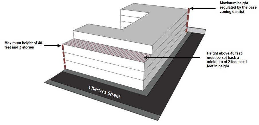
ii. Properties bounded by Homer Plessy Way and Chartres, Montegut, and Dauphine Streets are permitted a maximum building height of forty (40) feet with a maximum of three (3) stories along Montegut Street, Chartres Street, and Dauphine Street frontages. Any additional height above forty (40) feet shall be setback from the property line a minimum distance of one (1) foot for every one (1) foot above forty (40) feet up to a maximum allowed by the base zoning district.
Figure 18-2: Building height Stepback Requirements for Properties Bounded by Homer Plessy Way and Chartres, Montegut and Dauphine Street (RIV-3 District
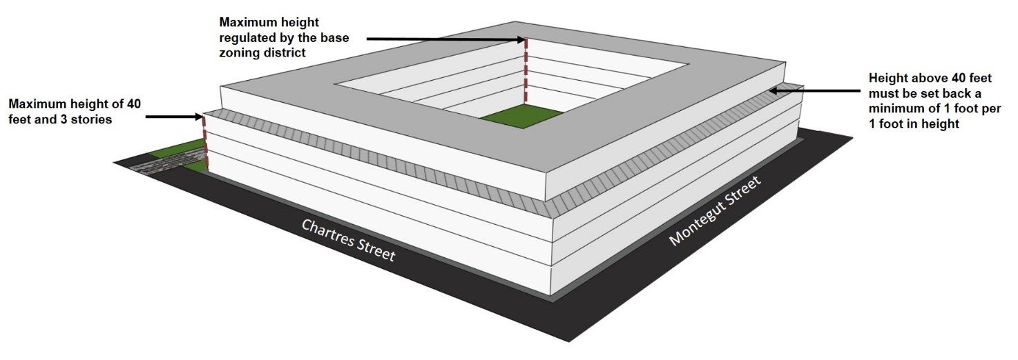
iii. Development sites with more than 100 feet of frontage may increase a portion (up to thirty-five percent (35%) of its street frontage) of their building height, to a maximum allowed by the base zoning district.
Figure 18-3: Allowable Building Height Variation Along Street
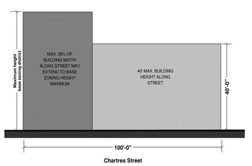
b. Flat roofed structures should provide an adequately-sized parapet in order to mitigate the sight of rooftop equipment.
c. Where provided as accessory flat roof features, open spaces located on roofs shall be excluded from the calculation of building height and gross floor area in accordance with Section 21.6.O.
Adopted by Ord. 27,674 MCS, §2, March 6, 2018, Zoning Docket 085-17; Ord. 28177, Sept. 5, 2019, ZD 41/19
18.13.H.3 Use Standards and Use Restictions
a. Required Uses for Ground Floors
Multi-family development that is forty-thousand (40,000) square feet or more in gross floor area shall allocate at least twenty percent (20%) of the floor area of the ground story for commercial or institutional use, subject to the permitted and conditional uses of the base zoning district. Floor area does not include corridors or other spaces used in common with other uses. Single-family dwellings, two-family dwellings, educational facilities, and townhouses are exempt from this use restriction.
b. Commercial Use Floor Area Limitation
In the RIV-3 Bywater Sub-District, each ground floor commercial use shall not exceed five thousand (5,000) square feet of total floor area unless approved as a conditional use.
c. Short-Term Rental Restriction
Commercial Short-Term Rentals are prohibited within the RIV-3 Bywater Sub-District.
Adopted by Ord. 27,674 MCS, §2, March 6, 2018, Zoning Docket 085-17
18.13.I RIV-4 Marigny Sub-District Standards
The following standards apply to the landside of the floodwall or levee:
Adopted by Ord. 27,674 MCS, §2, March 6, 2018, Zoning Docket 085-17
18.13.I.1 Design Standards
a. Buildings shall generally be built along the lot lines on streets parallel to the river.
b. Building facades along major access corridors, those parallel to the river, shall include architectural features to avoid the appearances of blank walls facing the street. These include, but are not limited to changes in the wall plane of at least six (6) inches such an offset, reveal, pilaster, or projecting rib, changes in wall texture or masonry patterns, colonnade, columns, or pilasters.
c. Buildings shall be designed with galleries, awnings, canopies, and other weather protections devices.
d. Pedestrian and main entrances shall be located on the streets parallel to the river.
e. First floor residential units located adjacent to the public street shall have individualized and direct entrances from the public sidewalk at the front (primary street) elevation, where possible.
f. Curb cuts and vehicular access areas should be located on secondary side streets, perpendicular to the river, if possible.
g. Areas dedicated to servicing and loading and vehicular access shall be minimized through the use of shared infrastructure and efficient layouts. Garage doors and service openings shall be minimal in size, and recessed or screened in order to be minimally visible from the street.
h. Developments shall contribute to traffic signaling or lane striping if deemed necessary by the Director of the Department of Public Works.
i. Developments shall include a type of neighborhood amenity or public open space such as, but not limited to, landscaped public open space, public art, mural, dog park, transit shelter, public rofftop access, restaurant with outdoor seating, or public plaza, subject to the Public Plaza Standards and Guidelines contained within Section 17.5.F.2 except that the plaza may be located more than three (3) feet above the adjacent sidewalk area in order to provide better views.
j. Historic buildings shall be retained and reused to the greatest extent possible.
Adopted by Ord. 27,674 MCS, §2, March 6, 2018, Zoning Docket 085-17
18.13.I.2 Building Heights
a. Stepbacks
i. Properties with street frontage located along Decatur Street between Elysian Fields Avenue and Saint Ferdinand Street, and street frontage on Chartres Street between Saint Ferdinand and Homer Plessy Way are permitted a maximum building height of forty (40) feet with a maximum of three (3) stories along the Decatur or Chartres Street frontage. Additional height above forty (40) feet shall be setback from the front property line at Decatur or Chartres Street at a minimum distance of fifty (50) feet up to a maximum allowed by the base zoning district but the additional height shall be set back a minimum distance of fifty (50) feet from the Decatur Street or Chartres Street frontage.
Figure 18-4: Building Height Stepback Requirement (RIV-4 District)
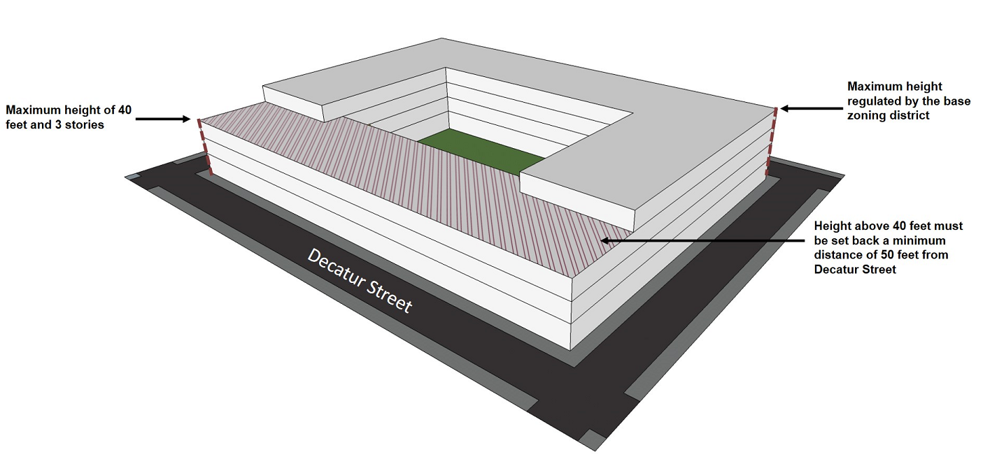
ii. Development sites with more than one-hundred (100) feet of frontage along Decatur or Chartres Streets may increase a portion (up to thirty-five percent (35%) if its primary street frontage) of their building height, to a maximum allowed by the base zoning district.
Figure 18-5: Allowable Building Height Variation Along Street

b. Flat roofed structures should provide an adequately-sized parapet in order to mitigate the sight of rooftop equipment.
c. Where provided as accessory flat roof features, open spaces located on roofs shall be excluded from the calculation of building height and gross floor area in accordance with Section 21.6.O.
Adopted by Ord. 27,674 MCS, §2, March 6, 2018, Zoning Docket 085-17; Ord. 28177, Sept. 5, 2019, ZD 41/19
18.13.I.3 Use Standards and Use Restriction
a. Required Uses for Ground Floors
Multi-family development that is forty-thousand (40,000) square feet or more in gross floor area shall allocate at least twenty percent (20%) of the floor area of the ground story for commercial or institutional use, subject to the permitted and conditional uses of the base zoning district. Floor area does not include corridors or other spaces used in common with other uses. Single-family dwellings, two-family dwellings, educational facilities, and townhouses are exempt from this use restriction.
b. Commercial Use Floor Area Limitation
In the RIV-4 Marigny Sub-District, each ground-floor commercial use shall not exceed five thousand (5,000) square feet of total floor area unless approved as a conditional use.
c. Short-Term Rental Restriction
Commercial Short-Term Rentals are prohibited within the RIV-4 Marigny Sub-District.
Adopted by Ord. 27,674 MCS, §2, March 6, 2018, Zoning Docket 085-17; Ord. 28177, Sept. 5 2019, ZD 41/19
18.14 CPC Character Preservation Corridor Design Overlay District
18.14.A Development Plan and Design Review Required
Development plan and design review is required for any new structure, addition, or enlargement in accordance with the thresholds of applicability in Section 4.5 as well as any additional thresholds of applicability of the CPC Overlay District.
18.14.B Additional Design Review Approval Standards
In addition to the development plan and design review standards of Section 4.5, the following additional approval standards shall be considered:
1. Design shall be compatible in scale, materials, street level uses, and spatial relationships with existing development in historic districts that retain unique character.
2. Design shall preserve the rhythm of the street, doorways, and windows, although minor variations to add interest are allowed.
3. Street façades shall be articulated with no blank walls along the street.
4. All sides and areas of structures visible to the public shall be treated with materials, finishes and architectural details appropriate to primary street-facing façades.
18.14.C CPC Overlay District Sub-Districts and Areas of Applicability
The CPC Overlay District contains the following sub-districts and areas of applicability:
18.14.C.1 CPC-1 Magazine Street Sub-District
The CPC-1 Magazine Street Sub-District applies to all lots with frontage on Magazine Street between the Pontchartrain Expressway and Leake Avenue. In addition to the thresholds of applicability for development plan and design review in Section 4.5, developments on lots within the entirety of each block located at the following intersections are also subject to development plan and design review:
a. Magazine Street and Jackson Avenue;
b. Magazine Street and Washington Avenue;
c. Magazine Street and Louisiana Avenue;
d. Magazine Street and Napoleon Avenue;
e. Magazine Street and Jefferson Avenue;
f. Magazine Street and Nashville Avenue.
18.14.C.2 CPC-2 St. Charles Avenue Sub-District
The CPC-2 St. Charles Avenue Sub-District applies to all lots with frontage on St. Charles Avenue between the Pontchartrain Expressway and Leake Avenue. In addition to the thresholds of applicability for development plan and design review in Section 4.5, developments on lots within the entirety of each block located at the following intersections are also subject to development plan and design review:
a. St. Charles Avenue and Martin Luther King Jr. Boulevard/Melpomene Avenue;
b. St. Charles Avenue and Jackson Avenue;
c. St. Charles Avenue and Washington Avenue;
d. St. Charles Avenue and Louisiana Avenue;
e. St. Charles Avenue and Napoleon Avenue;
f. St. Charles Avenue and Jefferson Avenue;
g. St. Charles Avenue and Nashville Avenue;
h. St. Charles Avenue and Broadway Street;
i. St. Charles Avenue and South Carrollton Avenue.
18.15 EC Enhancement Corridor Design Overlay District
18.15.A Development Plan and Design Review Required
Development plan and design review is required for any new structure, addition, or enlargement in accordance with the thresholds of applicability in Section 4.5 as well as any additional thresholds of applicability of the EC Overlay District.
18.15.B Additional Design Review Approval Standards
In addition to the development plan and design review standards of Section 4.5, the following additional approval standards shall be considered:
1. Development shall promote safe, convenient, and attractive pedestrian and bicycle access.
2. Compact neighborhood centers shall be created at major intersections to the extent possible in order to support transit.
3. Development shall ensure compatibility between commercial uses and surrounding residential areas.
4. The architectural design should be consistent with the context, character, scale and materials of structures in the adjacent areas.
5. Neon signage is prohibited on the interior or exterior of windows, other than an “open” sign.
18.15.C EC Overlay District Sub-Districts and Areas of Applicability
The EC Overlay District contains the following sub-districts and areas of applicability:
18.15.C.1 EC-1 Upper Tchoupitoulas Street Sub-District
The EC-1 Sub-District applies to all lots with frontage on either side of Tchoupitoulas Street from Jackson Avenue to Audubon Park, excluding any portion of a lot on the riverside of the floodwall. In addition to the thresholds of applicability for development plan and design review in Sections 4.5, the following developments are also subject to development plan and design review:
a. The forty-thousand (40,000) square foot threshold within Sections 4.5 is reduced to twenty-thousand (20,000) square feet of gross floor area on the lake side of Tchoupitoulas Street west of or upriver from Jackson Avenue, including any areas within the RIV Overlay District.
18.15.C.2 EC-2 North/South Claiborne Avenues Sub-District
The EC-2 Sub-District applies to all lots with frontage on North and South Claiborne Avenues within the boundaries of the City. In addition to the thresholds of applicability for development plan and design review in Section 4.5, the developments on lots within the entirety of each block located at the following intersections are also subject to development plan and design review:
a. North Claiborne Avenue and Tupelo Street;
b. North Claiborne Avenue and Caffin Avenue;
c. North Claiborne Avenue and Forstall Street;
d. North Claiborne Avenue and Poland Avenue;
e. North Claiborne Avenue and Louisa Street;
f. North Claiborne Avenue and Franklin Avenue;
g. North Claiborne Avenue and Elysian Fields Avenue;
h. North Claiborne Avenue and St. Bernard Avenue;
i. North Claiborne Avenue and Esplanade Avenue;
j. North Claiborne Avenue and Basin Street/Orleans Avenue;
k. North Claiborne Avenue and Lafitte Avenue;
l. North Claiborne Avenue and St. Louis Street;
m. North Claiborne Avenue and Bienville Avenue;
n. North/South Claiborne Avenue and Canal Street;
o. South Claiborne Avenue and Tulane Avenue;
p. South Claiborne Avenue and Earhart Boulevard;
q. South Claiborne Avenue and Martin Luther King Jr Boulevard;
r. South Claiborne Avenue and Jackson Avenue;
s. South Claiborne Avenue and Washington Avenue;
t. South Claiborne Avenue and Toledano Street;
u. South Claiborne Avenue and Louisiana Avenue;
v. South Claiborne Avenue and Napoleon Avenue;
w. South Claiborne Avenue and Jefferson Avenue;
x. South Claiborne Avenue and Nashville Avenue;
y. South Claiborne Avenue and Broadway Street;
z. South Claiborne Avenue and South Carrollton Avenue;
aa. South Claiborne Avenue and Leonidas Street.
18.15.C.3 EC-3 North/South Broad Street Sub-District
The EC-3 Sub-District applies to all lots with frontage on North and South Broad Streets between Treasure Street and Napoleon Avenue. In addition to the thresholds of applicability for development plan and design review in Section 4.5, the developments on lots within the entirety of each block located at the following intersections are also subject to development plan and design review:
a. North Broad Street and Treasure Street;
b. North Broad Street and St. Bernard Avenue;
c. North Broad Street and Bayou Road;
d. North Broad Street and Esplanade Avenue;
e. North Broad Street and Ursulines Avenue;
f. North Broad Street and Orleans Avenue;
g. North Broad Street and Lafitte Avenue;
h. North Broad Street and St. Louis Street;
i. North Broad Street and Bienville Avenue;
j. North/South Broad Street and Canal Street;
k. South Broad Street and Banks Street;
l. South Broad Street and Tulane Avenue;
m. South Broad Street and Earhart Boulevard;
n. South Broad Street and Martin Luther King Jr Boulevard.
18.15.C.4 EC-4 North/South Jefferson Davis Parkway Sub-District
The EC-4 Sub-District applies to all lots with frontage on North and South Jefferson Davis Parkways between Lafitte Avenue and Walmsley Avenue. In addition to the thresholds of applicability for development plan and design review in Section 4.5, the developments on lots within the entirety of each block located at the following intersections are also subject to development plan and design review:
a. North Jefferson Davis Parkway and Lafitte Avenue;
b. North Jefferson Davis Parkway and Conti Street;
c. North/South Jefferson Davis Parkway and Canal Street;
d. South Jefferson Davis Parkway and Tulane Avenue;
e. South Jefferson Davis Parkway and Washington Avenue.
18.15.C.5 EC-5 North/South Carrollton Avenue Sub-District
The EC-5 Sub-District applies to all lots with frontage on North and South Carrollton Avenues between Leake Avenue and City Park Avenue. In addition to the thresholds of applicability for development plan and design review in Section 4.5, the developments on lots within the entirety of each block located at the following intersections are also subject to development plan and design review:
a. North Carrollton Avenue and St. Louis Street;
b. North/South Carrollton Avenue and Canal Street;
c. South Carrollton Avenue and Tulane Avenue;
d. South Carrollton Avenue and Washington Avenue/Palmetto Street;
e. South Carrollton Avenue and Earhart Boulevard;
f. South Carrollton Avenue and South Claiborne Avenue;
g. South Carrollton Avenue and St Charles Avenue.
18.15.C.6 EC-6 Earhart Boulevard/Calliope Street Sub-District
The EC-6 Sub-District applies to all lots with frontage on Earhart Boulevard/Calliope Street and its extension between the Orleans Parish/Jefferson Parish boundary line and Oretha Castle Haley Boulevard. In addition to the thresholds of applicability for development plan and design review in Section 4.5, the developments on lots within the entirety of each block located at the following intersections are also subject to development plan and design review:
a. Earhart Boulevard and South Broad Street;
b. Earhart Boulevard and South Claiborne Avenue;
c. Earhart Boulevard and Simon Bolivar Avenue;
d. Calliope Street and Oretha Castle Haley Boulevard.
18.15.C.7 EC-7 Tulane Avenue Sub-District
The EC-7 Sub-District applies to all lots with frontage on Tulane Avenue between South Rampart Street and South Hennessey Street. In addition to the thresholds of applicability for development plan and design review in Section 4.5, the developments on lots within the entirety of each block located at the following intersections are also subject to development plan and design review:
a. Tulane Avenue and South Carrollton Avenue;
b. Tulane Avenue and Jefferson Davis Parkway;
c. Tulane Avenue and South Broad Street;
d. Tulane Avenue and South Claiborne Avenue;
e. Tulane Avenue and Loyola Avenue//Elk Place;
f. Tulane Avenue and South Rampart Street.
18.15.C.8 EC-8 Canal Street Sub-District
The EC-8 Sub-District applies to all lots with frontage on Canal Street between the North/South Rampart Street and City Park Avenue. In addition to the thresholds of applicability for development plan and design review in Section 4.5, the developments on lots within the entirety of each block located at the following intersections are also subject to development plan and design review:
a. Canal Street and North/South Carrollton;
b. Canal Street and Jefferson Davis Parkway;
c. Canal Street and North/South Broad Street;
d. Canal Street and North/South Claiborne Avenue;
e. Canal Street and North/South Rampart Street.
18.15.C.9 EC-9 St. Bernard Avenue Sub-District
The EC-9 Sub-District applies to all lots with frontage on St. Bernard Avenue between North Rampart Street/McShane Place and Harrison Avenue. In addition to the thresholds of applicability for development plan and design review in Section 4.5, the developments on lots within the entirety of each block located at the following intersections are also subject to development plan and design review:
a. St. Bernard Avenue and North Rampart Street/McShane Place;
b. St. Bernard Avenue and North Claiborne Avenue;
c. St. Bernard Avenue and North Broad Street.
18.15.C.10 EC-10 Elysian Fields Avenue Sub-District
The EC-10 Sub-District applies to all lots with frontage on Elysian Fields Avenue between North Peters Street and Lake Shore Drive. In addition to the thresholds of applicability for development plan and design review in Section 4.5, the developments on lots within the entirety of each block located at the following intersections are also subject to development plan and design review:
a. Elysian Fields Avenue and St. Claude Avenue;
b. Elysian Fields Avenue and North Claiborne Avenue;
c. Elysian Fields Avenue and Gentilly Boulevard;
d. Elysian Fields Avenue and Fillmore Street;
e. Elysian Fields Avenue and Robert E Lee Boulevard.
18.15.C.11 EC-11 Rampart Street/St. Claude Avenue Sub-District
The EC-11 Sub-District applies to all lots with frontage on North Rampart Street and St. Claude Avenue between Iberville Street and the Orleans Parish/St. Bernard Parish boundary, with the exception that it does not apply to lots located within the boundaries of the Vieux Carré Historic District. In addition to the thresholds of applicability for development plan and design review in Section 4.5, the developments on lots within the entirety of each block located at the following intersections are also subject to development plan and design review:
a. North Rampart Street/McShane Place and St. Bernard Avenue;
b. St. Claude Avenue and Elysian Fields Avenue;
c. St. Claude Avenue and Franklin Avenue;
d. St. Claude Avenue and Louisa Street;
e. St. Claude Avenue and Poland Avenue;
f. St. Claude Avenue and Forstall Street;
g. St. Claude Avenue and Caffin Avenue;
h. St. Claude Avenue and Tupelo Street.
18.15.C.12 EC-12 Oak Street Sub-District
The EC-12 Sub-District applies to all lots with frontage on Oak Street between South Carrollton Avenue and the Orleans Parish/Jefferson Parish boundary line. In addition to the thresholds of applicability for development plan and design review in Section 4.5, the developments on lots within the entirety of each block located at the following intersections are also subject to development plan and design review:
a. Oak Street and Leonidas Street.
18.15.C.13 EC-13 St. Roch Avenue Sub-District
The EC-13 Sub-District applies to all lots with frontage on St. Roch Avenue between St. Claude Avenue and North Roman Street. In addition to the thresholds of applicability for development plan and design review in Section 4.5, the developments on lots within the entirety of each block located at the following intersections are also subject to development plan and design review:
a. St. Roch Avenue and St. Claude Avenue;
b. St. Roch Avenue and North Claiborne Avenue.
18.15.C.14 EC-14 Orleans Avenue/Basin Street Sub-District
The EC-14 Sub-District applies to all lots with frontage on Orleans Avenue/Basin Street between St. Louis Street and North Broad Street. In addition to the thresholds of applicability for development plan and design review in Section 4.5, the developments on lots within the entirety of each block located at the following intersections are also subject to development plan and design review:
a. Orleans Avenue and North Claiborne Avenue;
b. Orleans Avenue and North Galvez Street;
c. Orleans Avenue and North Miro Street.
18.15.C.15 EC-15 Washington Avenue/Toledano Street Sub-District
The EC-15 Sub-District applies to all lots with frontage on Washington Avenue between South Jefferson Davis Parkway and South Dorgenois and all lots with frontage on Toledano Street between South Broad Street and South Claiborne Avenue. In addition to the thresholds of applicability for development plan and design review in Section 4.5, the developments on lots within the entirety of each block located at the following intersections are also subject to development plan and design review:
a. Washington Avenue and South Jefferson Davis Parkway;
b. Washington Avenue and South Broad Street;
c. Toledano Street and South Galvez Street.
18.15.C.16 EC-16 Freret Street/La Salle Street/Louisiana Avenue/Simon Bolivar Avenue Sub-District
The EC-16 Sub-District applies to all lots with frontage on Freret Street between Napoleon Avenue and Louisiana Avenue, all lots with frontage on Louisiana Avenue between South Claiborne Avenue and La Salle Street, all lots with frontage on La Salle Street between Louisiana Avenue and First Street, and all lots with frontage on Simon Bolivar Avenue between First Street and the Pontchartrain Expressway. In addition to the thresholds of applicability for development plan and design review in Section 4.5, the developments on lots within the entirety of each block located at the following intersections are also subject to development plan and design review:
1. Freret Street and Louisiana Avenue;
2. Louisiana Avenue and Toledano Street;
3. Louisiana Avenue and La Salle Street;
4. La Salle Street and Washington Avenue;
5. La Salle Street and First Street;
6. Simon Bolivar Avenue and Jackson Avenue;
7. Simon Bolivar Avenue and Martin Luther King Jr Boulevard;
8. Simon Bolivar Avenue and Earhart Boulevard.
18.15.C.17 EC-17 Oretha Castle Haley Sub-District
The EC-17 Sub-District applies to all lots with frontage on Oretha Castle Haley Boulevard between the Pontchartrain Expressway and Philip Street. In addition to the thresholds of applicability for development plan and design review in Section 4.5, the developments on lots within the entirety of each block located at the following intersections are also subject to development plan and design review:
a. Oretha Castle Haley Boulevard and Jackson Avenue;
b. Oretha Castle Haley Boulevard and Felicity Street;
c. Oretha Castle Haley Boulevard and Martin Luther King Jr Boulevard;
d. Oretha Castle Haley Boulevard and the Pontchartrain Expressway.
18.15.C.18 EC-18 Gentilly Sub-District
The EC-18 Sub-District applies to all lots with frontage on Gentilly Boulevard between St. Bernard Avenue and the Peoples Avenue Canal, and to all lots within the area bounded by St. Denis Street, Gentilly Boulevard, Norman Mayer Avenue, St. Anthony Avenue, Mandolin Street, Elysian Fields Avenue, St. Aloysius Drive, Mandeville Street, Gentilly Boulevard, Fairmont Drive, Monterey Street, and Elysian Fields Avenue. In addition to the thresholds of applicability for development plan and design review in Section 4.5, the developments on lots within the entirety of each block located at the following intersections are also subject to development plan and design review:
a. Gentilly Boulevard and Paris Avenue;
b. Gentilly Boulevard and Peoples Avenue.
18.16 CT Corridor Transformation Design Overlay District
18.16.A Development Plan and Design Review Required
Development plan and design review is required for any new structure, addition, or enlargement in accordance with the thresholds of applicability in Section 4.5 as well as any additional thresholds of applicability of the CT Overlay District.
18.16.B Additional Design Review Approval Standards
In addition to the site plan and design review standards of Section 4.5, the following additional approval standards shall be considered:
1. Development should promote pedestrian-friendly and bicycle-friendly environments.
2. Planned developments and development at designated major intersections should include a well-designed and functional public realm, which provides publicly-accessible amenities.
3. Parking should not be the dominant visual element of the site along the primary frontage. Parking should be designed as smaller multiple parking lots separated by landscape and buildings, or placement behind buildings.
4. The architectural design should be consistent with the context, character, scale and materials of structures in the adjacent areas.
5. Compact, transit-ready neighborhood centers with walkable environments should be created where future “bus rapid transit” stops are expected.
6. Development facing the lakefront and facing or adjacent to man-made water bodies should enhance the waterfront context, including creation of amenities through stormwater management.
7. Neon signage is prohibited on the interior or exterior of windows, other than an “open” sign.
18.16.C CT Overlay District Sub-Districts
The CT Corridor Transformation Overlay District contains the following sub-districts:
18.16.C.1 CT-1 Eastern New Orleans Renaissance Corridor Sub-District
a. The CT-1 Sub-District applies to the following lots:
i. All lots bounded by Bullard Avenue, Hayne Boulevard, the Jahncke Canal, and Chef Menteur Highway, and all lots fronting on the west side of Bullard Avenue between Hayne Boulevard and Chef Menteur Highway.
ii. All lots with frontage on Crowder Boulevard between Hayne Boulevard and Chef Menteur Highway.
iii. All lots with frontage on Read Boulevard between Hayne Boulevard and Chef Menteur Highway.
iv. All lots fronting on Hayne Boulevard between Jourdan Road and Interstate 510.
v. All lots fronting on Morrison Road between Jourdan Road and Interstate 510.
vi. All lots fronting on Lake Forest Boulevard between Mayo Road and Interstate 510 and continuing one block in depth along Six Flags Parkway between Interstate 510 and Michoud Boulevard.
vii. All lots fronting on Bundy Road between Hayne Boulevard and Chef Menteur Highway.
viii. All lots fronting on Interstate 10 and Interstate 510 and the service roads on both sides of Interstate 10 and Interstate 510 east of the Industrial Canal.
ix. All lots fronting on Chef Menteur Highway for the entirety of its length from the Industrial Canal to the Michoud Levee and along Downman Road for the entirety of its length from Chef Menteur Highway to Lake Pontchartrain.
b. In addition to the thresholds of applicability for development plan and design review in Section 4.5, the developments on lots within the entirety of each block located at the following intersections are also subject to development plan and design review:
i. Hayne Boulevard and Downman Road;
ii. Morrison Road and Downman Road;
iii. Morrison Road and Bundy Road;
iv. Morrison Road and Read Boulevard;
v. Morrison Road and Wright Road/Lucerne Street;
vi. Morrison Road and Bullard Avenue;
vii. Morrison Road and Gannon Road;
viii. Interstate 10 Service Road and Crowder Boulevard;
ix. Interstate 10 Service Road and Bundy Road;
x. Interstate 10 Service Road and Read Boulevard;
xi. Interstate 10 Service Road and Wright Road;
xii. Interstate 10 Service Road and Bullard Avenue;
xiii. Dwyer Road and Downman Road;
xiv. Dwyer Road and Mayo Road;
xv. Dwyer Road and Crowder Boulevard;
xvi. Dwyer Road and Bundy Road;
xvii. Dwyer Road and Read Boulevard;
xviii. Dwyer Road and Bullard Avenue;
xix. Chef Menteur Highway and Interstate 10;
xx. Chef Menteur Highway and Wilson Avenue;
xxi. Chef Menteur Highway and Crowder Boulevard;
xxii. Chef Menteur Highway and Bundy Road;
xxiii. Chef Menteur Highway and Read Boulevard;
xxiv. Chef Menteur Highway and Wright Road;
xxv. Chef Menteur Highway and Bullard Avenue;
xxvi. Chef Menteur Highway and Michoud Boulevard;
xxvii. Chef Menteur Highway and Alcee Fortier Boulevard.
18.16.C.2 CT-2 West Bank Corridor Sub-District
a. The CT-2 Sub-District applies to the following lots:
i. All lots along General DeGaulle Drive/Woodland Highway between the Westbank Expressway and the Intracoastal Waterway;
ii. All lots with frontage on Behrman Place and Behrman Highway between General DeGaulle Drive and the Orleans Parish/Jefferson Parish boundary line;
iii. All lots along within the entirety of all non-residential zoning districts that abut General Meyer Avenue between Behrman Avenue and Bennett Street; and
iv. All lots with frontage on Holiday Drive between General DeGaulle Drive and Behrman Place.
b. In addition to the thresholds of applicability for development plan and design review in Section 4.5, the developments on lots within the entirety of each block located at the following intersections are also subject to development plan and design review:
i. General DeGaulle Boulevard and MacArthur Boulevard; and
ii. General DeGaulle Boulevard and Woodland Drive.
18.16.C.3 CT-3 Gentilly/Lakeview Corridor Sub-District
a. The CT-3 Sub-District applies to the following lots:
i. All lots with frontage on Harrison/W. Harrison Avenue between Orleans Avenue and the 17th Street Canal;
ii. All lots with frontage on Robert E Lee Boulevard between West End Boulevard and Peoples Avenue.
b. In addition to the thresholds of applicability for development plan and design review in Section 4.5, the developments on lots within the entirety of each block located at the following intersections are also subject to development plan and design review:
i. Harrison Avenue and Canal Boulevard;
ii. Harrison Avenue and Argonne Boulevard;
iii. Robert E. Lee Boulevard and Canal Boulevard;
iv. Robert E. Lee Boulevard and Paris Avenue;
v. Robert E. Lee Boulevard and Elysian Fields Avenue;
vi. Robert E. Lee Boulevard and Franklin Avenue;
vii. Canal Boulevard and Aymard Court;
viii. Canal Boulevard and Homedale Street.
Adopted by Technical Correction #5, 12-17-18
18.17 GC Greenway Corridor Design Overlay District
18.17.A Applicability
The GC Greenway Corridor Design Overlay District is intended as an overlay district to promote an active public edge by ensuring pedestrian and bicycle-oriented design in new development and redevelopment on lots fronting officially designated greenways. The GC Greenway Corridor Design Overlay District applies to the following areas:
1. All lots within blocks located adjacent to or across a public right-of-way from the Lafitte Greenway. For the purposes of this section, the Lafitte Greenway is defined as: (1.) the area bounded by Basin Street, Lafitte Avenue, North Jefferson Davis Parkway, and St. Louis Street; and (2) the entirety of the St. Louis Street right-of-way between North Jefferson Davis Parkway and Canal Boulevard.
18.17.B Development Plan and Design Review Required
Development plan and design review is required for any new structure, addition, or enlargement in accordance with the thresholds of applicability in Section 4.5.
18.17.C Additional Design Review Approval Standards
In addition to the site plan and design review standards of Section 4.5, the following additional approval standards shall be considered:
1. New development should promote safe, convenient and attractive pedestrian and bicycle access to the greenway.
2. Main pedestrian entrances of new developments shall be oriented, wherever possible, toward the greenway and toward major streets that intersect the greenway, and shall be clearly articulated through façade variations, overhangs, and/or other design elements.
3. Curb cuts and loading and service areas shall not be located adjacent to or facing the greenway or along major streets intersecting the greenway, wherever possible. Where curb cuts, loading and service areas and vehicular parking must be located adjacent to or facing a greenway or on a major street intersecting the greenway, they shall be designed to minimize conflicts between motorized vehicles and pedestrian and bicycle traffic.
4. Building façades shall contain variation in façade materials, and shall employ offsets, fenestration, bays and balconies, etc. in order to eliminate blank walls, enhance the architectural character of development in the greenway corridor, and encourage passive surveillance of the greenway. The ground floor walls of commercial uses shall maintain a transparency of forty percent (40%). Windows shall be constructed of clear or lightly tinted glass. Tinting above twenty percent (20%) or reflective glass is prohibited.
5. Surface parking lots shall be set back a minimum of ten feet (10’) from a property line adjacent to or facing a greenway, with a landscape buffer provided.
6. No billboard may be erected, constructed, altered, maintained, or relocated within the GC Greenway Corridor Design Overlay District.
7. Neon signage is prohibited on the interior or exterior of windows, other than an “open” sign.
18.18 HU-B1A Use Restriction Overlay District
18.18.A Applicability
HU-B1A Use Restriction Overlay applies to the following areas of applicability:
1. All lots zoned HU-B1A Historic Urban Neighborhood Business District in the area bounded by the Mississippi River, Canal Street, traveling Northwest Canal Street to South Robertson, traveling Northeast on South Robertson to St. Louis Street to North Broad Street to Bayou Road, traveling Northwest on Bayou Road to Gentilly Boulevard, traveling Northeast on Gentilly Boulevard to Desaix Boulevard, traveling West on Desaix Boulevard to Wisner Boulevard, traveling South on Wisner Boulevard to City Park Avenue, traveling West on City Park Avenue to Pontchartrain Boulevard and then West on Metairie Road to the Orleans/Jefferson parish line, and from Orleans/Jefferson parish line to the Mississippi River.
18.18.B Use Restrictions
1. When allowed as a permitted use in the base zoning district, the following use requires conditional use approval in accordance with Section 4.3, subject to the use standards of Article 20.3.ZZ.
a. Restaurant, Standard
b. Alcohol beverage sales in an existing standard restaurant if not already permitted by a conditional use.
c. Notwithstanding the definition of live entertainment, secondary use, as described in Section 26.6, any live performance in a standard restaurant shall be a conditional use.
18.19 LAS LaSalle Street Overlay District
18.19.A Applicability
The LAS Overlay District is intended to create an environment with additional opportunities for live entertainment at commercially-zoned sites along commercial corridors, as well as at small sites with commercial zoning that are interspersed within neighborhoods where arts and cultural uses have historically existed. The LAS Overlay District applies to the following area:
1. All lots in non-residential districts bounded by Louisiana Avenue and Washington Avenue with building frontages on LaSalle Street.
18.19.B Uses
18.19.B.1 Conditional Uses
In addition to all uses authorized in the base district, the following uses are allowed as conditional uses subject to the use standards of Article 20 and Paragraph C below.
a. Live Entertainment – Secondary Use
b. Hotel/Motel
18.19.C Use Standards
18.19.C.1 Live Entertainment – Secondary Use
a. All establishments providing live entertainment shall hold the appropriate Live Entertainment Permit.
b. All establishments providing live entertainment are subject to a closed doors and windows policy during any performance.
c. All establishments providing live entertainment are subject to the applicable noise, litter, and other laws of the City, including the Comprehensive Zoning Ordinance, Building Code, City Code, and Life Safety Code.
d. A bar may provide live entertainment, including a permanent area for dancing, but adult uses and karaoke are prohibited. All bars providing live entertainment shall hold a Class A General ABO Permit and the appropriate Live Entertainment Permit.
e. Live entertainment performances are restricted to the hours between 10:00a.m. and 12:00 Midnight on all days, provided that additional hours of operation may be considered and granted through the conditional use process.
18.20 Magazine Street Use Restriction Overlay District
18.20.A Applicability
The Magazine & Maple Street Use Restriction Overlay applies to the following sub-districts and areas of applicability:
1. All lots within the HU-B1 Historic Urban Neighborhood Business District on the squares with Magazine Street frontage from Race Street including the riverside downriver corner, to Philip Street, including the riverside, upriver corner; all lots within the HU-B1 District on squares with frontage on Sophie Wright Place from Magazine Street to Race Street.
2. All lots within the HU-B1 Historic Urban Neighborhood Business or HU-MU Historic Urban Mixed Use Districts on squares with Magazine Street frontage between Washington Avenue, including the downriver corners, and Henry Clay Avenue.
18.20.B Use Restrictions
18.20.B.1 Conditional Uses
When allowed as a permitted use in the base zoning district, the following use requires conditional use approval in accordance with Section 4.3, subject to the use standards of Article 20.3.ZZ.
a. Restaurant, Standard
b. Alcohol beverage sales in an existing standard restaurant if not already permitted by a conditional use
c. Notwithstanding the definition of live entertainment, secondary use, as described in Section 26.6, any live performance in a standard restaurant shall be a conditional use.
18.21 Jackson Avenue Use Restriction Overlay District
18.21.A Applicability
The Jackson Avenue Use Restriction Overlay applies to all residentially zoned lots forming the upriver side of Jackson Avenue between St. Charles Avenue and Prytania Street.
18.21.B Use Restrictions
18.21.B.1 Conditional Uses
When allowed a permitted use in the same base zoning district, the following uses require conditional use approval in accordance with Section 4.3.
1. Day Care Home, Adult or Child – Small
18.21.B.2 Prohibited
The following uses are prohibited:
1. Neighborhood Commercial Establishment
18.22 Annunciation Street Overlay District
18.22.A Applicability
The Annunciation Street Overlay District is intend to create additional height and floor allowances while also providing additional use restrictions and additional permitted uses in the following area:
1. All property in square 116, located at 1301 Annunciation Street.
18.22.B Minimum Lot Area
Multi-Family dwelling developments within this district shall be allowed a minimum lot area of 535 square feet per dwelling unit.
Adopted by Ord. No. 27,406, §1, May 24, 2017, Zoning Docket 13/17
18.22.C Maximum Height and Floors
Main structures on applicable lots within the Annunciation Street Overlay District may have a height of up to 60 feet and may have up to four (4) floors.
Adopted by Ord. No. 27,406, §1, May 24, 2017, Zoning Docket 13/17
18.22.D Use Restrictions
18.22.D.1 Prohibited
The following uses are prohibited:
1. Gas Stations
2. Parking Lots (Principal Use)
3. Parking Structure (Principal Use)
18.22.D.2 Conditional Uses
The following uses are conditional:
1. Hotel
18.22.E Permitted Uses
The following uses are permitted:
1. Mini-Warehouse
18.23 Canal Street Height Overlay District
18.23.A Applicability
The Canal Street Height Overlay District is intended to create additional height and floor allowances for sites adjacent to the Life Sciences Mixed Use District. The Canal Street Height Overlay District applies to the following area:
1. All lots within the MU-1 Mixed-Use District and HU-MU Historic Urban Neighborhood Mixed-Use District within squares with frontage on Canal Street between Dorgenois Street and Claiborne Avenue.
18.23.B Maximum Height and Floors
Main structures on applicable lots within the Canal Street Height Overlay District may have a height of up to 85 feet and may have up to seven floors.
18.24 CCN (Convention Center Neighborhood) Overlay District
Adopted by Jan. 20, 2017, Zoning Docket 102-16, Ord. 27,261 MCS, §1; Ord. 29285 MCS, 1-5-23, ZD 64/22
18.24.A Applicability
The CCN (Convention Center Neighborhood) Overlay District shall supersede the base zoning district regulations and permit additional height and density in the following boundaries of the CCN Overlay District:
- The area bounded by Convention Center Boulevard, The Pontchartrain Expressway, Thalia Street, Annunciation Street, Euterpe Street, Tchoupitoulas Street, Celeste Street, The Mississippi River Floodwall, and Henderson Street, excluding SQ RP-5X LOT MF-1.
- All aggregate calculations apply only to the area bounded by Convention Center Boulevard, The Pontchartrain Expressway, Thalia Street, Annunciation Street, Euterpe Street, Tchoupitoulas Street, Orange Street, The Mississippi River Floodwall, and Henderson Street, excluding SQ RP-5X LOT MF-1. See Figure 18-6.
Figure 18-6: Aggregate Calculations Site Plan
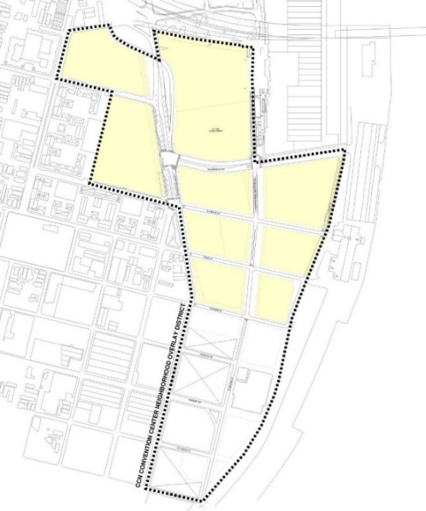
Adopted by Ord. 27,261 MCS, §1, Jan. 20, 2017, Zoning Docket 102-16; Ord. 29285 MCS, 1-5-23, ZD 64/22
18.24.B Development Plan, Neighborhood Participation, and Design Review Required
1. Development Master Plan Submittal
Prior to the issuance of any building permits for structures exceeding the base zoning district’s maximum height, a Development Master Plan shall address the general layout of the entire overlay area, including a plan for proposed structures and open space, traffic pattern plan, parking plan, and access points. The Development Master Plan shall include the following:
a. The location, square footage and building heights of all existing and proposed structures and uses intended.
b. A landscape plan for the area within the first twenty-five (25) feet of the lot boundaries. Landscape shall be in accordance with Article 23.
c. Stormwater management plan, including all on-site filtration and detention facilities. The plan shall be reviewed with consultation of the Department of Safety & Permits.
d. A perimeter sign plan for the area within the first twenty-five (25) feet of the lot boundaries. Signs shall be in accordance with Article 24.
e. A traffic plan shall include the following components: circulation routes for motor vehicle, bicycle and pedestrian transportation modes; ingress and egress locations for each transportation mode; curb side usage; locations and capacity of all off-street parking and loading spaces; traffic control during peak hours; and an inventory of way finding signage, pedestrian beacons, crosswalk striping, and ADA compliance shall be included. The City Planning Commission Executive Director shall consult with the Department of Public Works Director and the Regional Transit Authority on the traffic plan.
f. A traffic impact analysis, which shall include the traffic load impact on surrounding public street system. The City Planning Commission Executive Director shall consult with the Department of Public Works Director, the Port of New Orleans, and Convention Center representatives on required traffic impact analysis and implementation of recommendations for the area.
g. A plan for the stabilization of historic landmarks to avoid further deterioration and illegal access.
h. A phasing plan showing how Public Benefits will comply in the aggregate area of Article 18.24.A and the timing of construction to establish the compliance for each Public Benefit shown below:
i. open spaces;
ii. district-based stormwater management systems; and
iii. affordable housing.
i. A comprehensive parking plan.
2. Development plan and design review is required for any new structure, addition, or enlargement in accordance with the thresholds of applicability in Article 4.5. Additionally, any development that exceeds the base zoning district maximum building height or any Stadium or Convention Center conditional use shall be subject to Development Plan and Design Review Article 4.5 with mandatory Design Advisory Committee consideration based on a Development Master Plan submission.
3. Project Neighborhood Participation Program (Project NPP) Requirements
a. The following submittals for the CCN Overlay District shall only be accepted by the City Planning Commission after completion of a Project Neighborhood Participation Program (Project NPP), subject to the requirements specified in item 3.b and 3.c below:
i. Development Master Plan, as described in Article 18.24.B.1;
ii. Applications for construction that exceed eighty-five (85) feet in height, unless the proposed building was approved in the Development Master Plan and has undergone only minor changes, as defined in Article 4.5.F.1, in which case no additional NPP shall be required; and
iii. Applications for construction that exceed forty thousand (40,000) square feet of buildable area, unless the proposed building was approved in the Development Master Plan and has undergone only minor changes, as defined in Article 4.5.F.1, in which case no additional NPP shall be required.
b. The development plan submittal shall not be deemed complete for the purpose of a completeness review as provided in Article 3.2.B until all required Project NPP documents are submitted, including the meeting notice letter, sign-in sheets, and Project NPP meeting summary.
c. Applicants shall follow all Project NPP requirements, including all content and general procedures applicable to map and/or text amendments, as provided in Article 4.2.D.2, except with regard to mailed notice, which shall be as follows. Mailed notice for the NPP shall be sent by regular mail at least fifteen (15) days before the public hearing to the parties identified in Sectio 3.3.B.2, except that such notice shall be expanded to all properties within 1,200 (one thousand two hundred) feet of property lines of the subject property. Additionally, mailed notice shall be provided to the Lower Garden District and Warehouse District neighborhood associations, as well as the office of Community Development for distribution to interested stakeholders, including but not limited to residents of River Garden developments.
Adopted by Ord. 27,261 MCS, §1, Jan. 20, 2017, Zoning Docket 102-16; Ord. 29285 MCS, 1-5-23, ZD 64/22
18.24.C Permitted and Conditional Uses
Table 18-1 shall substitute and supersede the base zoning district’s Permitted and Conditional Uses found in Table 15-1. Only those land uses listed under Table 18-1 as Permitted or Conditional Uses are allowed within the CCN Overlay District. A “P” indicates that the use is permitted within that Overlay District. A “C” indicates that the use is a conditional use in that Overlay District and that a conditional use approval is required, in accordance with Article 4.3. In addition, the City Planning Commission and the Council decisions on applications for a conditional use shall evaluate the following factors, specific to the CCN Overlay District:
1. The proposed use is compatible with the CCN Overlay District's purpose to promote a walkable, mixed-use, and mixed-income neighborhood with public benefits.
2. The proposed use preserves and promotes public access to the CCN Overlay District, including sightlines and/or director access to the Mississippi Riverfront.
3. The proposed use does not create a material detriment to the public health, safety, and welfare to properties and residents within the CCN Overlay District, as well as neighbors in surrounding areas, including but not limited to the Lower Garden District, Warehouse District, and River Garden developments.
The absence of the use from the table indicates that use is prohibited within the Overlay District.
|
Table 18-1 Permitted and Conditional Uses
|
|
CCN Convention Center
Neighborhood Overlay District
|
P - Permitted Use,
C - Conditional Use
|
Use Standards
|
|
RESIDENTIAL USE
|
|
Bed and Breakfast - Accessory
|
P
|
Section 20.3.I
|
|
Bed and Breakfast - Principal
|
P
|
Section 20.3.I
|
|
Day Care Home, Adult - Small
|
P
|
Section 20.3.T
|
|
Day Care Home, Adult - Large
|
P
|
Section 20.3.T
|
|
Dwelling, Above the Ground Floor
|
P
|
|
|
Dwelling, Single-Family
|
P
|
|
|
Dwelling, Small Multi-Family Affordable
|
P
|
Section 20.3.SSS
|
|
Dwelling, Two-Family
|
P
|
Section 20.3.Y
|
|
Dwelling, Townhouse
|
P
|
Section 20.3.X
|
|
Dwelling, Multi-Family
|
P
|
|
|
Group Home, Small
|
P
|
Section 20.3.GG
|
|
Group Home, Large
|
P
|
Section 20.3.GG
|
|
Group Home, Congregate
|
C
|
Section 20.3.GG
|
|
Home Based Child Care, Small
|
P
|
Section 20.3.T
|
|
Home Based Child Care, Large
|
P
|
Section 20.3.T
|
|
Permanent Supportive Housing
|
P
|
Section 20.3.PP
|
|
Residential Care Facility
|
P
|
Section 20.3.YY
|
|
Short Term Rental, Large
|
P
|
Section 20.3.LLL
|
|
Short Term Rental, Small
|
P
|
Section 20.3.LLL
|
|
COMMERCIAL USE
|
|
Amusement Facility, Indoor
|
P
|
Section 20.3.E
|
|
Amusement Facility, Outdoor
|
P
|
Section 20.3.E
|
|
Art Gallery
|
P
|
|
|
Arts Studio
|
P
|
|
|
Animal Hospital
|
P
|
|
|
Auditorium
|
P
|
|
|
Bar
|
P
|
Section 20.3.G
|
|
Broadcast Studio
|
P
|
|
|
Bus Terminal
|
C
|
|
|
Car Wash
|
C
|
Section 20.3.L
|
|
Catering Kitchen
|
P
|
|
|
Check Cashing Establishment
|
P
|
Section 20.3.O
|
|
Child Care Center, Small
|
P
|
Section 20.3.S
|
|
Child Care Center, Large
|
P
|
Section 20.3.S
|
|
Cigar Bar
|
C
|
|
|
Convention Center
|
C
|
|
|
Day Care Center, Adult or Child - Small
|
P
|
Section 20.3.S
|
|
Day Care Center, Adult - Large
|
P
|
Section 20.3.S
|
|
Day Care Center, Adult - Commercial
|
P
|
Section 20.3.S
|
|
Drive-Through Facility
|
P1
|
Section 20.3.V
|
|
Financial Institution
|
P
|
|
|
Funeral Home
|
P
|
|
|
Greenhouse/Nursery
|
P
|
|
|
Gas Station
|
C
|
Section 20.3.EE
|
|
Grocery Store
|
P
|
|
|
Health Club
|
P
|
|
|
Hostel
|
P
|
|
|
Hotel/Motel
|
P/C5
|
|
|
Live Entertainment – Secondary Use
|
P
|
Section 20.3.JJ
|
|
Live Performance Venue
|
P
|
Section 20.3.JJ
|
|
Mardi Gras Den
|
P
|
|
|
Medical/Dental Clinic
|
P
|
|
|
Micro-Brewery
|
P
|
|
|
Micro-Distillery
|
P
|
|
|
Motor Vehicle Dealership, Small
|
P
|
|
|
Movie Studio
|
P
|
|
|
Office
|
P
|
|
|
Outdoor Amphitheater
|
C
|
Section 20.3.UUU
|
|
Outdoor Live Entertainment – Secondary Use
|
C
|
Section 20.3.VVV
|
|
Personal Service Establishment
|
P
|
|
|
Pet Day Care Service
|
P
|
Section 20.3.QQ
|
|
Printing Establishment
|
P
|
|
|
Public Market
|
P
|
Section 20.3.TT
|
|
Reception Facility
|
P
|
Section 20.3.WW
|
|
Recording Studio
|
P
|
|
|
Restaurant, Carry-Out
|
P
|
Section 20.3.ZZ
|
|
Restaurant, Fast Food
|
P
|
Section 20.3.ZZ
|
|
Restaurant, Standard
|
P
|
Section 20.3.ZZ
|
|
Restaurant, Specialty
|
P
|
Section 20.3.ZZ
|
|
Retail Goods Establishment
|
P
|
|
|
Retail Sales of Packaged Alcoholic Beverages
|
P
|
|
|
Short Term Rental, Commercial
|
P
|
Section 20.3.LLL
|
|
Small Box Variety Store
|
P
|
Section 20.3.NNN
|
|
Social Club or Lodge
|
P
|
Section 20.3.CCC
|
|
Stadium
|
C
|
|
|
Wine Shop
|
P
|
|
|
Winery
|
P
|
|
|
INDUSTRIAL USE
|
|
Brewery
|
P2
|
|
|
Distillery
|
P2
|
|
|
District Energy System
|
P
|
Section 20.3.QQQ
|
|
Food Processing
|
P
|
|
|
Manufacturing, Artisan
|
P
|
|
|
Manufacturing, Light
|
P
|
|
|
Mini-Warehouse (Self-Storage)
|
P
|
|
|
Research & Development
|
P
|
|
|
Warehouse
|
P
|
|
|
INSTITUTIONAL USE
|
|
Community Center
|
P
|
|
|
Convent and Monastery
|
P
|
|
|
Cultural Facility
|
P
|
Section 20.3.R
|
|
Educational Facility, Primary
|
P
|
Section 20.3.Z
|
|
Educational Facility, Secondary
|
P
|
Section 20.3.Z
|
|
Educational Facility, University
|
P
|
|
|
Educational Facility, Vocational
|
P
|
Section 20.3.Z
|
|
Emergency Shelter
|
C
|
Section 20.3.AA
|
|
Government Offices
|
P
|
|
|
Hospital
|
P
|
|
|
Hospitality Center
|
P
|
|
|
Place of Worship
|
P
|
|
|
Public Works & Safety Facility
|
P
|
|
|
Social Club or Lodge
|
P
|
Section 20.3.CCC
|
|
OPEN SPACE USE
|
|
Agriculture – No Livestock
|
P
|
Section 20.3.C
|
|
Parks and Playgrounds
|
P
|
|
|
Stormwater Management (Principal Use)
|
P
|
|
|
OTHER
|
|
Parking Structure (Principal Use)
|
P
|
Section 20.3.OO
|
|
Planned Development
|
C
|
Article 5
|
|
Pumping Station
|
P
|
Section 20.3.UU
|
|
Utilities
|
P3
|
Section 20.3.GGG
|
|
Wireless Telecommunications Antenna & Facility
|
C, P4
|
Section 20.3.JJJ
|
|
Wireless Telecommunications Tower & Facility
|
C
|
Section 20.3.JJJ
|
1. Drive-through facilities in the CCN Overlay District are allowed as permitted uses where they are proposed to be constructed in combination with either a financial institution or a retail goods establishment in order to provide or dispense medical or pharmaceutical products. Drive-through facilities in the CCN Overlay District shall be located behind structures out of view from the public right-of-way.
2. Only breweries and distilleries that produce fewer than 12,500 barrels per year are considered permitted uses.
3. Electrical Utility Substations and Transmission Lines shall be subject to design review as per Article 4, Section 4.5.B.5 and Table 4-2.
4. Only wireless telecommunications antennas that comply with the stealth design standards of Section 20.3.JJJ are considered permitted uses.
5. Hotels shall be considered permitted if they:
(1) are located on the same square as a cultural facility of at least 10,000 square feet in size; or
(2) have less than 180 individual guest rooms and are located at least 300 feet from any residential zoning district, as measured from the closest lot line.
Hotels shall be prohibited if:
- There is already one (1) hotel permitted on the square; or
- They are within the square bounded by Annunciation, Melpomene, Euterpe, and Tchoupitoulas Streets (exculding Lot MF-1), or the square bounded by Thalia, Annunciation, Melpomene, and Tchoupitoulas Streets.
All other hotels shall be a conditional use.
Adopted by Ord. 27,261 MCS, §1, Jan. 20, 2017, Zoning Docket 102-16; Ord. 29285 MCS, 1-5-23, ZD 64/22
18.24.D Site Design Standards
Adopted by Ord. 27,261 MCS, §1, Jan. 20, 2017, Zoning Docket 102-16; Ord. 29285 MCS, 1-5-23, ZD 64/22
18.24.D.1 Bulk and Yard Regulations
Bulk and Yard Regulations for the CCN Overlay District shall be as provided in Table 18-2.
Table 18-2: Bulk and Yard Regulations
|
TABLE 18-2: BULK REGULATIONS
|
|
MINIMUM LOT AREA PER
DWELLING UNIT
|
None
|
|
MAXIMUM BUILDING HEIGHT
|
See 18.24.D.6 Maximum Building Height and Table 18-3.
|
|
MINIMUM PERMEABLE OPEN SPACE
|
Calculated as aggregate; 20% of the area as defined within 18.24.A.2.1 Other areas within the CCN Overlay District are subject to the permeable open space requirement of the base zoning district.
|
|
MINIMUM YARD REQUIREMENTS
|
|
FRONT YARD
|
a. For the lots bounded by Henderson Street, Convention Center Boulevard, Orange Street, and Front Street, the minimum is 30’ and maximum is 50’ abutting Convention Center Boulevard.
b. For the lots bounded by Henderson Street, Convention Center Boulevard, Orange Street, and Tchoupitoulas Street, the minimum is 15’ and maximum is 25’ abutting Convention Center Boulevard.
c. The minimum is 12’ and maximum is 22’ for lots abutting Euterpe Street, Race Street, and Orange Street.
d. All other lots: None.
|
|
INTERIOR SIDE YARD
|
All other lots: None, unless abutting a residential district then 5'.
|
|
CORNER SIDE YARD
|
None.
|
|
REAR YARD
|
None, unless abutting a residential district then 20'.
|
TABLE 18-2 FOOTNOTES
1 Developments subject to this section include projects undertaken in phases, stages, or otherwise developed in distinct sections or lots. If the development contains a phasing plan, the phasing plan shall provide for the minimum permeable open space as required within this section, calculated as aggregate of the area defined within 18.24.A.2.
18.24.D.2 Required On-Site Public Open Space
To establish publicly accessible open space, the following standards in subsection “a.” shall apply to the areas described in subsections b and c below:
a. Public Park and Plaza
- Parks or plazas shall be open to the sky, except for arbors, trellises or small pedestrian-oriented structures.
- Parks or plazas shall have a minimum site area of two-thousand five-hundred (2,500) square feet per square.
- At least twenty percent (20%) of the park or plaza shall consist of landscaping.
- A minimum of one (1) linear foot of seating area shall be provided for each thirty (30) square feet of park or plaza.
- All parks or plazas shall be visible from and connected to the nearest sidewalk with preference given to corner locations that maximize pedestrian access.
- Parks or plazas shall be designed in accordance with ADA accessibility requirements. No plaza may be more than three (3) feet above the adjacent sidewalk level.
- Parks or plazas shall be open to the public at minimum during the hours of 8:00 a.m. to 9:00 p.m. daily. A plaque two (2) feet by four (4) feet in area shall be displayed at all entrances stating the hours of public use unless the park or plaza is open 24 hours per day.
- Plazas shall be located so that they receive natural light during a portion of the day.
b. For the properties bounded by Henderson Street, Convention Center Boulevard, Orange Street, and Tchoupitoulas Street, a minimum of two-hundred (200) feet of the street frontage along Convention Center Boulevard shall exceed the maximum Front Yard Requirement as defined within Table 18-2: Bulk and Yard Regulations to provide publicly accessible open space with amenities such as, but not limited to, landscaped public open space, public art, mural, dog park, transit shelter, public rooftop access, outdoor seating of a restaurant, or public plaza subject to the Public Plaza Standards and Guidelines contained within Article 18.24.D.2.a.
c. For the properties bounded by Henderson Street, Convention Center Boulevard, Orange Street, and Front Street, the Front Yard along Convention Center Boulevard shall be publicly accessible open space with amenities such as, but not limited to, landscaped public open space, public art, mural, dog park, transit shelter, public rooftop access, outdoor seating of a restaurant, or public plaza.
18.24.D.3 Design Standards
The following design standards only apply to development within the area denoted in Article18.24.A.2, as illustrated in Figure 18-6. The design standards in this section shall take the place of the building design standards under Article 15.3.B. All other parcels within the CCN Overlay District shall be governed by the base underlying zoning design standards and applicable overlay district standards.
a. Pedestrian and main entrances shall be located on the public right-of-way. Public entrances shall be articulated and distinct from the structures primary massing. Unless deemed and ruled as unfeasible, curb cuts shall be located on the secondary streets.
b. Ventilation grates, emergency exit doors, and similar functional elements shall be designed as decorative elements and integrated into the overall building design.
c. Security bars are prohibited. Roll-up or accordion security grilles are permitted on the ground floor when constructed of a see-through, non-solid material. The casing shall be painted to match the building and shall not damage or obscure architectural detailing.
d. Plain mansard roofs are prohibited. Decorative mansard roofs are permitted on buildings with a minimum wall height of two (2) stories. (See Figure 15-2: Examples of Decorative Mansard Roofs).
e. Buildings shall be designed with galleries, awnings, canopies, and other weather protection devices.
f. Decorative elements having historically functional purposes, such as shutters, balconies, windows, and doors, shall be operational.
g. Any structure designed for a ground floor non-residential use shall be designed with a minimum ceiling height of twelve (12) feet, except for parking areas.
h. Loading areas for retail anchor stores of twelve thousand (12,000) square feet in gross floor area or more are required to be located in the rear. Where possible, loading and service areas shall be internal to the development block and accessed through service corridors and not through pedestrian-oriented streets.
i. Outlot buildings shall be designed with showcase windows and entrances oriented to the street.
j. Secondary access points are encouraged from rear parking lots. Facades that abut parking areas and contain a public entrance shall include pedestrian walkways.
k. When a shopping center is located behind a parking lot, a street presence for the shopping center shall be created by locating part of the center and/or outlot buildings near the lot line at the primary street corner or the shopping center entrance. When the center’s frontage on the primary street exceeds two-hundred fifty (250) feet in width, part of the center and/or outlot buildings shall hold at least fifty percent (50%) of the front lot line. (See Figure 15-3: Building Siting).
l. The following building materials are prohibited on exterior elevations visible from the public right-of-way. However, such materials may be used as part of decorative or detail elements, or as part of the exterior construction that is not used as a surface finish material.
1. Exterior insulating finish systems (EIFS)
2. Stuccato Board
3. Vinyl Siding
m. The site shall be designed to ensure safe pedestrian access to the building from the street and from any parking areas. Safe pedestrian access to and from adjacent buildings is also required. Sidewalks shall extend to the lot line and connect to existing sidewalks on abutting properties.
n. Within any yards of the development and the public right-of-way adjacent to the development, special finishes shall be included as part of a cohesive streetscape design. These include coordinated paving, design treatments for the pedestrian level, street lighting, and street furniture. The streetscape design shall be coordinated with the building design.
o. Off-street vehicle parking shall be set behind structures whenever possible.
p. Curb cuts shall be limited along transit lines to greatest extent feasible.
q. View corridors from streets that are generally perpendicular to the River shall be maintained.
18.24.D.4 Affordable Housing
a. A minimum of ten percent (10%) of total housing units shall be affordable housing units in accordance with Article 28.3 Affordable Housing Development Use Standards and Guidelines and may be calculated as aggregate in the area described in Article 18.24.A.2.
b. For rental projects, the affordable units in an Affordable Housing Development shall be rented to families earning no more than 60% of the Area Median Income (AMI).
c. In the aggregate area described in Article 18.24.A.2, the Article 28.6 Payment In-Lieu Fee option shall not apply.
d. Affordable housing units shall be subject the Affordable Housing Development Design Article 28.4.B through 28.4.D and shall be subject to Article 28.8 Compliance and Monitoring.
1. The affordable housing units shall be comparable to the market-rate dwelling units in terms of floor area and exterior finishes. Interior finishes or appliances may be different if functionality and longevity are retained.
2. The residents of the affordable housing units shall have access to the same amenities as the residents of the market-rate dwelling units.
3. Affordable units shall utilize the same entrances as market-rate units and shall not have separate entrances.
4. The bedroom mix (i.e., the number of bedrooms) of the affordable housing units shall be proportional to the market-rate dwelling units.
e. An additional ten percent (10%) of total housing units shall be workforce housing and rented to families earning no more than one hundred twenty percent (120%) of the Area Median Income (AMI).
18.24.D.5 Traffic Impact Analysis
The City Planning Commission Executive Director shall require a traffic impact analysis and compliance with the recommendations therein for any Stadium or Convention Center conditional use, any new structure, or major renovation exceeding the base zoning district’s maximum building height and not covered by an approved Development Master Plan. The City Planning Commission Executive Director may require further Traffic Impact Analyses or Traffic Plans based on changes to the proposed uses or development plan. The Traffic Impact Analysis shall be approved by the City Planning Commission Executive Director after consultation with the Department of Public Works Director.
18.24.D.6 Maximum Building Height
a. In lieu of the base zoning district regulations, maximum building height shall be established by Table 18-3. Some squares are identified by their planned bounding streets because square numbers may change due to re-subdivision. Figure 18-7 is shown with corresponding height limits for reference; however, Table 18-3 shall control.
b. In squares along Tchoupitoulas Street, the maximum building height of Table 18-3 shall be achieved by line-of-sight from the opposite side of Tchoupitoulas Street methodology established in Figure 18-8 over the base zoning district’s 85 ft. height limit.
|
TABLE 18-3: MAXIMUM BUILDING HEIGHT
|
|
Square
|
Maximum Building Height
|
|
Square bounded by: Convention Center Boulevard, Calliope, Henderson, and Tchoupitoulas Streets
|
200 feet
|
|
Square bounded by: Thalia, Annunciation, Melpomene, and Tchoupitoulas Streets
|
85 feet and no more than 7 stories
|
|
Square bounded by: Annunciation, Melpomene, Euterpe and Tchoupitoulas Streets (but excluding Lot MF-1)
|
85 feet and no more than 7 stories
|
|
Square bounded by: Convention Center Boulevard, Henderson, Euterpe, and Tchoupitoulas Streets
|
85 to 400 feet, subject to the line-of-sight setbacks shown in figure 18-8
|
|
Square bounded by: Convention Center Boulevard, Henderson, Euterpe, and Front Streets
|
400 feet
|
|
Square bounded by: Convention Center Boulevard, Race, Euterpe and Tchoupitoulas Streets
|
85 to 400 feet, subject to the line-of-sight setbacks shown in figure 18-8
|
|
Square bounded by: Convention Center Boulevard, Race, Euterpe and Front Streets
|
400 feet
|
|
Square bounded by: Convention Center Boulevard, Race, Orange, and Tchoupitoulas Streets
|
85 to 400 feet, subject to the line-of-sight setbacks shown in figure 18-8
|
|
Square 39 bounded by: Orange, Richard, S. Peters, and Tchoupitoulas Streets
|
85 to 125 feet, subject to the line-of-sight setbacks shown in figure 18-8
|
|
Squares 21-B and 22-B: bounded by: the floodwall, Orange, Market, and S. Peters Streets
|
21-B: 400 feet
22-B: 200 feet
|
|
Square 23-B: bounded by: the floodwall, Market, S. Peters, and St. James Streets
|
125 feet
|
|
Square 38 bounded by: Market, Richard, S. Peters, and Tchoupitoulas Streets
|
85 to 125 feet, subject to the line-of-sight setbacks shown in figure 18-8
|
|
Square 36 bounded by: Market, St. James, S. Peters, and Tchoupitoulas Streets
|
85 to 125 feet, subject to the line-of-sight setbacks shown in figure 18-8
|
|
Square 35 bounded by: Celeste, St. James, S. Peters, and Tchoupitoulas Streets
|
85 to 125 feet, subject to the line-of-sight setbacks shown in figure 18-8
|
|
Square 24B bounded by: the extension of St. James Street, S. Peters Street, and the floodwall
|
85 feet and no more than 7 stories
|
c. A height of up to one hundred seventy-five (175) feet shall be allowed for transparent protective screening (fencing) including poles and other necessary structural elements encompassing the perimeter of outdoor amusement or sports facilities for public safety purposes.
Figure 18-7: Maximum Building Height - Perspective
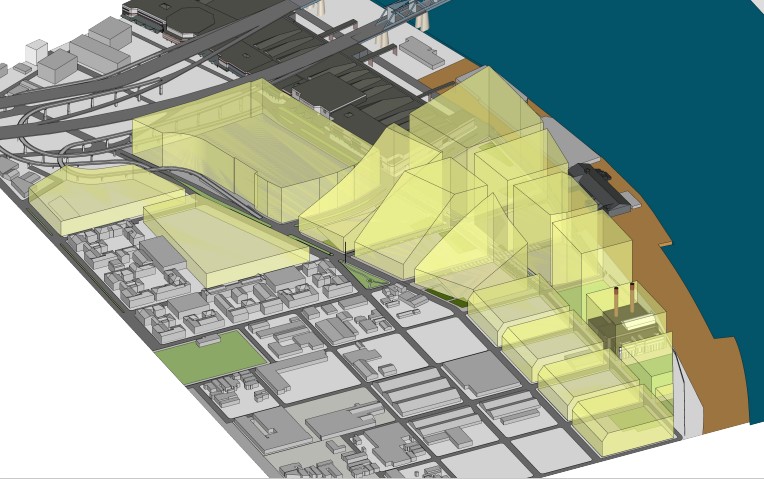
Figure 18-8: Tchoupitoulas Street Line-of-Sight
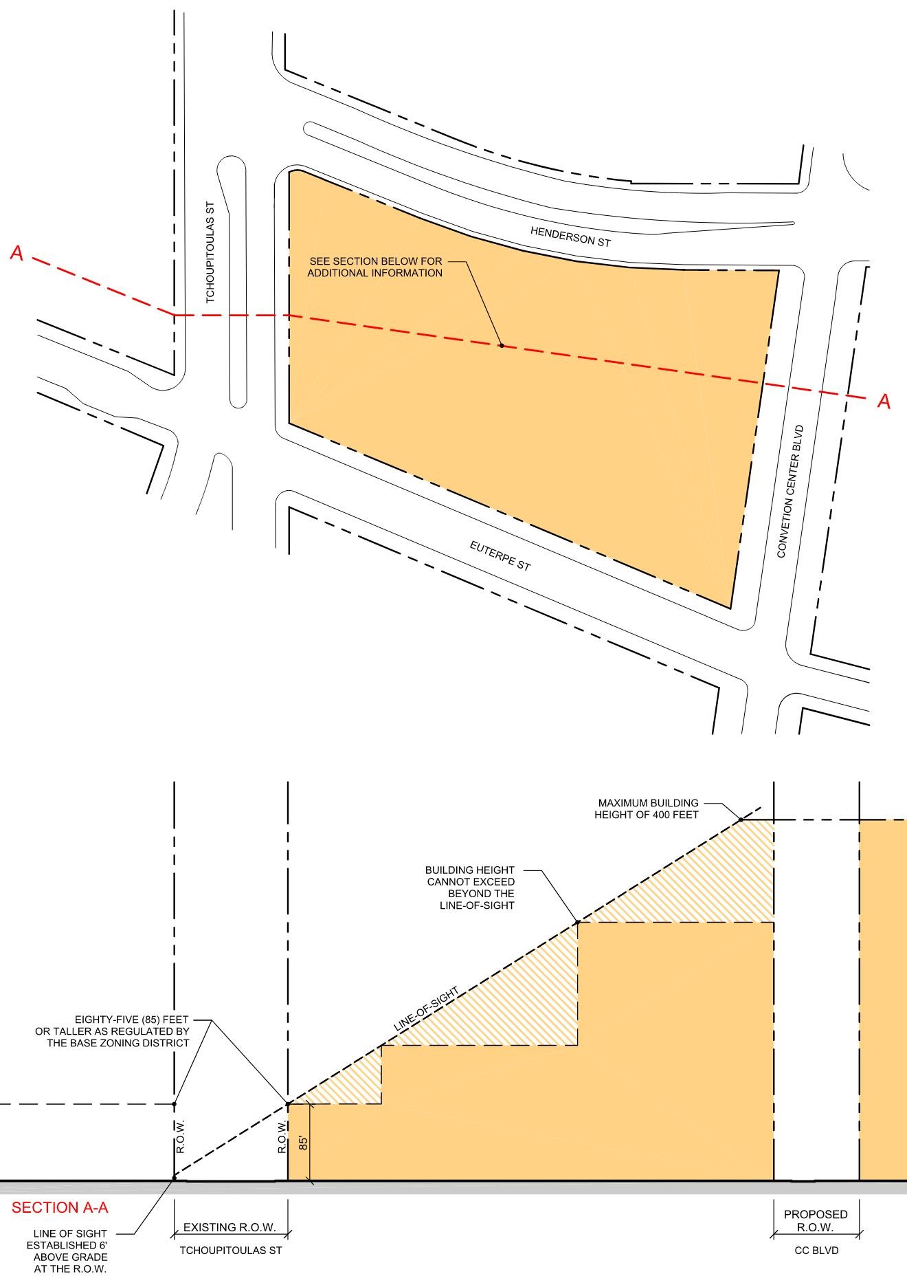
18.24.D.7 Parking
The Convention Center Neighborhood Overlay District is exempt from the vehicle parking requirements of Table 22-1. Notwithstanding this exemption, accessory parking lots may be provided in accordance with the Maximum Vehicle Parking Limitations of Article 22.4.B as if off-street vehicle parking is required.
Additional temporary surface parking shall be permitted subject to time restrictions up to 5 years. Permanent parking lots shall be subject to the standards of the Overlay District and Article 23 of the Comprehensive Zoning Ordinance, while certain design standards for temporary parking lots may be suspended commensurate with the time restrictions as set forth by the City Planning Commission and approved in the Development Master Plan.
18.25 SBA St. Bernard Avenue Overlay District
Adopted by Ord. No. 27,459, §1, July 20, 2017, Zoning Docket 35/17
18.25.A Applicability
The SBA St. Bernard Avenue Overlay District is intended to create density allowances for sites maintaining frontage along St. Bernard Avenue while also reducing the parking requirement for Residential Care Facilities.
- The SBA St. Bernard Avenue Overlay District applies to all properties that allow multi-family development and Residential Care Facilities on blocks with frontage on St. Bernard Avenue from the I-10 overpass/North Claiborne Avenue to North Dorgenois Street that require Article 4, Section 4.5 Development and Design Review approval.
Adopted by Ord. No. 27,459, §1, July 20, 2017, Zoning Docket 35/17
18.25.B Density Bonus for SBA St. Bernard Avenue Overlay District
In the establishment and authorization of a development in the SBA St. Bernard Avenue Overlay District, the following provides the baseline for determining whether a project qualifies for a development bonus. The project may be awarded a maximum of thirty percent (30%) reduction in the minimum lot area per dwelling unit requirements.
- The development provides an affordable housing component on-site. Affordable housing shall be evenly distributed throughout the project, and shall be comparable to market-rate units in size, bedroom mix, and exterior finishes. A qualifying project is entitled to a development bonus if it meets one (1) of the following thresholds and maintains affordability for a period of at least fifty (50) years:
- Five percent (5%) of units aside at thirty percent (30%) AMI should yield a fifteen percent (15%) reduction in the minimum lot area per dwelling unit requirements.
- Five percent (5%) of units aside at fifty percent (50%) AMI should yield a ten percent (10%) reduction in the minimum lot area per dwelling unit requirements.
- Five percent (5%) of units aside at eighty percent (80%) AMI should yield a five percent (5%) reduction in the minimum lot area per dwelling unit requirements.
The development bonuses provided in items a., b., and c. above may be combined to provide a total bonus of up to 30%. All affordable housing provided pursuant to this section shall comply with the Affordable Housing Standards and Guidelines provided in Section 17.5.H.2, except where such standards conflict with the provisions of this section.
Adopted by Ord. No. 27,459, §1, July 20, 2017, Zoning Docket 35/17
18.25.C Additional Density Bonus for SBA St. Bernard Overlay District
Residential Care Facility projects providing affordable senior housing located within the SBA St. Bernard Overlay District and exceeding the baseline density bonus as stated above in Section 18.25.B, may be awarded an additional thirty percent (30%) reduction for a maximum of sixty percent (60%) reduction in the minimum lot area per dwelling unit requirements and may also receive a maximum height allowance of fifty-five feet (55').
- The development provides an affordable senior housing component in a Residential Care Facility on-site. Affordable senior housing shall be evenly distributed throughout the project, and shall be comparable to market-rate units in size, bedroom mix, and exterior finishes. A qualifying project is entitled to a development bonus if it meets the thresholds in Section 18.25.B, the following threshold, and maintains affordability for a period of at least fifty (50) years.
- Projects providing more than fifty percent (50%) of units aside at sixty percent (60%) or less AMI should yield a sixty percent (60%) reduction in the minimum lot area per dwelling unit requirements and a maximum height allowance of fifty-five feet (55').
Adopted by Ord. No. 27,459, §1, July 20, 2017, Zoning Docket 35/17
18.25.D Reduced Off-Street Parking Allowance
Residential Care Facility projects providing affordable senior housing and meeting the Density Bonus thresholds outlined in sections 18.25.B and 18.25.C shall be required to provide a minimum of .25 off-street parking spaces per dwelling unit.
Adopted by Ord. No. 27,459, §1, July 20, 2017, Zoning Docket 35/17
18.26 MIDDLE HARRISON USE RESTRICTION OVERLAY DISTRICT
Adopted by Ord. No. 27,665, §2, February 8, 2018, Zoning Docket 097/17;
18.26.A APPLICABILITY
The Middle Harrison Use Overlay District applies to the following areas:
- Those lots in Lakeview that front on Harrison Avenue between Canal Boulevard and West End Boulevard.
Adopted by Ord. No. 27,665, §2, February 8, 2018, Zoning Docket 097/17; Ord. No. 27,961, §1, December 27, 2018, Zoning Docket 113/18;
18.26.B USE RESTRICTIONS
1. Any use, or the aggregate of uses, over four thousand (4,000) square feet in gross floor area on one lot is prohibited.
2. Maximum number of Standard Restaurants shall remain at five (5).
3. All standard restaurants are conditional uses.
4. Allow only one restaurant (of any type) in each 100 block (restaurants facing Canal Boulevard and West End Boulevard would count to that 100 block of Harrison).
**All six (6) restaurants presently operating and all five (5) restaurants in the 500 and 600 blocks of Harrison Avenue shall be grandfathered at their present location of operation.
5. Specialty Restaurants shall be a maximum of 1,250 square feet.
6. Specialty/Carryout/Fast Food Restaurants shall not serve alcohol for consumption on premises or be sold as packaged.
7. The following uses are prohibited: gas station, motor vehicle repair, minor, fast food restaurant, alcoholic beverage sales in a specialty restaurant, and bar.
Use Standards
- No music shall be allowed to be played at a business that is audible outside and/or have external speakers.
- Signs advertising the business shall not be allowed as monument signs on front lawns but must be attached to the front of the building to not block sight lines of side streets and alley ways exiting onto Harrison Avenue.
- Restaurants shall not open for business before 7:00 a.m. or seat new customers after 9:00 p.m.
- Buildings must have a 5 ft. setback from the sidewalk, with the area landscaped to be used as green space only.
- Deliveries and trash between 10:00 p.m. and 7:00 a.m. is prohibited.
Adopted by Ord. No. 27,665, §2, February 8, 2018, Zoning Docket 097/17; Ord. No. 27,961, §1, December 27, 2018, Zoning Docket 113/18; Ord.28328 MCS, 4-15-20, ZD 115/19
18.27 Coronet Court Multi-Family Housing Overlay District
18.27.A Applicability
1. Those lots generally bounded by Lake Forest Boulevard, Mayo Road, the Interstate 10 Service Road and the Lawrence Canal.
Adopted by Ord. 28479 MCS, 9-3-20, ZD 42/20
18.27.B Uses
18.27.B.1 Permitted Uses
In addition to all uses authorized in the base district the following uses are permitted uses subject to the use standards of Article 20:
a. Dwelling, Established Multi-Family
b. Dwelling, Established Townhouse
18.28 ALGIERS RIVERFRONT USE AND HEIGHT RESTRICTION OVERLAY
18.28.A Applicability
The restrictions contained herein shall apply to all lots within the following boundaries: from the Mississippi River at the Orleans/Jefferson Parish line to Brooklyn Avenue, the along Brooklyn Avenue to Powder Street, Powder Street to the top of the levee, continuing along the levee to Morgan Street, continuing along Morgan Street until Patterson Road, continuing in the downriver direction along the Patterson Street right-of-way to the Bermuda Street right-of-way, and from the Bermuda Street right-of-way north to the Mississippi River.
Adopted by Ord. 28676 MCS, ZD 3/21, 5-20-21
18.28.B Uses
18.28.B.1 Prohibited Uses
a. Where otherwise permitted in the base zoning, the following use is prohibited:
1. Gas Station.
b. Where otherwise permitted in the base zoning, the following uses require conditional use approval by the City Council:
1. Bar.
2. Check Cashing Establishment
3. Motor Vehicle Service Repair, Minor
4. Small Box Variety Store
18.28.C. Building Design Limitations
The following building design standards and requirements shall apply to any new structure, major renovation, or expansion within the boundaries of the Algiers Riverfront Use and Height Overlay District, without regard to its use:
a. Except as provided in Subsection b, the height shall be limited to sixty (60) feet and no more than five (5) stories, and the density as provided in the base zoning district, unless the building meets the standards described in Article 18, Section 18.13.G.
b. For properties with street frontage located along Brooklyn Avenue between Opelousas Avenue and Socrates Street, including lots that front the following streets that intersect with Brooklyn Avenue: Opelousas, Slidell Street, Homer, Newton, Diana, LaMarque, Socrates, Ptolemy, and Lawrence Streets - the height shall be limited to forty (40) feet and no more than three (3) stories, and the density as provided in the base zoning district, unless the building meets the standards described in Article 18, Section 18.13.G.
1. Such properties are permitted a maximum building height of forty (40) feet with a maximum height of three (3) stories along the Brooklyn Avenue frontage.
2. Any additional height above forty (40) feet, obtained through the height bonus provided in Article 18, Section 18.13.G, shall be set back from the front property line at Brooklyn Avenue at a minimum distance of one (1) foot for every one (1) foot in height, up to a maximum of sixty (60) feet and five (5) stories.
c. Flat roofed structures shall provide an adequately-sized parapet in order to mitigate the sight of rooftop equipment.
d. Where provided as accessory flat roof features, open spaces located on roofs shall be excluded from the calculation of building height and gross floor area in accordance with Section 21.6.O.
18.29 FRENCH MARKET OVERLAY DISTRICT
18.29.A AREA OF APPLICABILITY
The area generally bounded by the riverside of Decatur Street, the downriver side of St. Peter Street (and its direct extension to the Mississippi River), the Mississippi River, the upriver side of Barracks Street (and its direct extension to the Mississippi River), French Market Place, and Ursulines Street.
18.29.B PUBLIC MARKET HOURS
The hours of operation of the existing Public Market (commonly known as the French Market Flea and Farmers Market) shall be expanded to permit a morning seafood and/or produce market beginning at 4:00 a.m., and to permit evening market closing hours at 10:00 p.m. on Sundays through Thursdays and 11:00 p.m. on Fridays and Saturdays. There shall be no live entertainment indoors or outdoors after 8:00 p.m. on any day.
18.29.C PERMITTED SIGNAGE
The following sign types are permitted within the French Market Overlay District:
1. Freestanding Multi-Tenant Monument signs shall be permitted, subject to the following standards:
a. One (1) Freestanding Multi-Tenant Monument Sign shall be permitted per building, to be located within breezeways between existing commercial structures.
b. No portion of the sign shall project beyond the front building wall of any existing commercial structure, where the structure’s front wall is adjacent to the public right-of-way, except at the Governor Nicholls Street breezeway between the farmers and flea markets, where no portion of the sign shall project beyond the roof line of the existing market shed structures.
c. These signs shall be limited to a maximum of six (6) feet in height. The area of each sign shall be limited to twenty-four (24) square feet.
d. A map of the area described above (the boundaries of the French Market Overlay District) may be included on the sign.
e. Tenant listing shall be limited to the name of the business and address. All listings shall be the same size.
f. The design and location of the signs shall be subject to the review and approval of the French Market Corporation and the staff of the Vieux Carré Commission.
g. The design and location of the signs shall be proposed by the French Market Corporation and shall be subject to the review and approval of the Vieux Carré Commission staff.
5. In lieu of the permitted Freestanding Multi-Tenant Monument Sign, where applicable, multi-tenant signs identifying individual tenant space shall be permitted to be co-located on an approved communications antennae installation, located within breezeways between buildings at St. Ann, Dumaine, St. Philip, and Governor Nicholls Streets, subject to the following standards:
a. One grouping of multi-tenant signs shall on a singular communications antenna shall be permitted per breezeway. The total square footage of signage on the antennae shall not exceed eight (8) square feet.
b. The design and location of the signs shall be proposed by the French Market Corporation and shall be subject to the review and approval of the Vieux Carré Commission staff.
6. Attached Permanent Directory Signs shall be permitted, subject to the following standards:
a. Attached Permanent Directory Signage shall only be permitted at the Public Market in the area generally bounded by Decatur, Barracks, N. Peters and Ursulines Streets.
b. One Attached Permanent Directory Sign shall be permitted per street frontage.
c. The sign area of each sign shall be limited to twelve (12) square feet.
d. The design and location of the signs shall be proposed by the French Market Corporation and shall be subject to the review and approval of the Vieux Carré Commission staff.
Adopted by Ord. 28713 MCS, 7-1-21, ZD 23/21
18.30 University Area Off-Street Parking Overlay District
18.30.A Applicability
Properties in the area generally bounded by: Cecil Street to Monticello Avenue, Monticello Avenue, to Leake Avenue, to River Drive, to Riverview Drive, to East Drive, to Tchoupitoulas Street, turning south on State Street, turning east on Front Street, turning north on Nashville Avenue, turning east on Tchoupitoulas Street, turning north on Jefferson Avenue, turning east on South Claiborne Avenue, turning north on Toledano Street, connecting to Washington Avenue, turning west on Earhart Boulevard, turning north on South Carrollton Avenue, turning west on Tulane Avenue/Airline Highway connecting to Palmetto Street, to Northline Street, to Monticello, to Cecil Street. Within this are, only properties zoned HU-RS Historic Urban Single-Family Residential, HU-RD1 Historic Urban Two-Family Residential, HU-RD2 Historic Urban Two-Family Residential, HU-RM1 Historic Urban Multi-Family Residential and HU-RM2 Historic Urban Multi-Family Residential Districts are subject to the University Area Off-Street Parking Overlay District's requirements.
Adopted by Ord. 28848 MCS, 11-18-21, ZD 44/21; Ord. 29761 MCS, 12-14-23, ZD 45/23
18.30.B Off-Street Parking Requirements
The university area off-street parking overlay requirements are as follows:
1. One (1) off-street parking space is required per new bedroom. "Bedroom" shall be defined as an enclosed private room that includes an operable window and a door that opens to a space other than another bedroom, bathroom, half-bath or toilet room.
a. A bedroom shall be considered an "existing bedroom" if the bedroom has historically been used as such and meets all bedroom requirements contained within this section, as determined by the Department of Safety and Permits. When there is contradictory or conflicting evidence, ambiguity and/or confusion as to the number of existing bedrooms, the question of the number of existing bedrooms shall be resolved in favor of the more restrictive interpretation and regulation.
b. A "proposed new additional bedroom" is any enclosed private room shown on plans for new construction and proposed renovations, that is not an existing bedroom, that is not a kitchen or bath, and that is not a non-enclosed area such as a common room or pass-through room as described within this section. All enclosed private rooms shown on any proposed plans are presumed to be bedrooms.
c. Every existing bedroom and proposed new additional bedroom in a dwelling unit must be an enclosed private room and must not be a non-enclosed common room or pass-through room. A pass-through room is a space or room with multiple doors that is primarily used for passage from one room or space to another in a dwelling unit.
d. Every existing bedroom and proposed new additional bedroom in a dwelling unit shall contain a minimum of seventy (70) square feet of floor area, and every bedroom intended for occupancy by more than one person shall contain a minimum of fifty (50) square feet of floor area per occupant.
e. In the case of a shotgun-style dwelling units with pass-through rooms, for the purposes of this Ordinance and calculating the required off-street parking spaces, the number of existing and proposed new additional bedrooms shall be the number of rooms remaining after excluding a common room, a kitchen, and bathrooms.
f. All restrictions, limitations and requirements contained in this overlay, including but not limited to those concerning existing and proposed new additional bedrooms in a dwelling unit, are in addition to restrictions, rules and requirements provided for elsewhere in the CZO, the City Code, the Building Code, Louisiana Law or any other applicable law or ordinance.
2. This off-street parking requirement shall apply to new construction, and any renovations of existing structures that result in an increase in existing bedrooms or bathrooms, as determined by the Department of Safety and Permits.
a. All structural renovation permit applications within the boundaries of this overlay that include alterations of additions to the structure's footprint shall include a recent survey of the property that shows all structures, fences, setbacks, and any existing nonconformities.
3. This off-street parking requirement shall not apply to new construction dwelling units with three (3) or fewer bedrooms, or renovations of existing dwelling units where the total number of bedrooms is three (3) or fewer as determined by the Department of Safety and Permits.
4. Any increase in bathrooms where the total number is more than two full and one half (2.5) per dwelling unit shall be prohibited in this overlay, as determined by the Department of Safety and Permits.
5. "Full Bathroom" shall be defined as an enclosed room with plumbing for a bathtub and/or shower. "Half Bathroom" shall be defined as an enclosed room with plumbing for a sink and toilet.
6. All new construction dwelling units or renovations to existing structures must include a non-enclosed common room or area containing a minimum of 120 square feet which cannot be used as a bedroom; or a minimum of 200 square feet if the non-enclosed common room includes a kitchen.
a. A common room is any non-enclosed room or space that is primarily used for non-private or communal purposes, including but not limited to living rooms and dining rooms, and any pass-through rooms used for transiting from one room to another. A non-enclosed common room or pass-through room shall not be a bedroom, and an enclosed private room shall not be a common room or pass-through room.
7. This off-street parking requirement shall only apply to properties zoned HU-RD1, HURD2, HU-RS, HU-RM1, and HU-RM2 as determined by the City Planning Commission and the Department of Safety and Permits.
8. All residentially-zoned properties with a homestead exemption shall be exempt from this overlay.
9. This off-street parking requirement shall not apply to any residential Affordable Housing development, as determined by the Department of Safety & Permits, that meets the following criteria:
a. Any affordable housing development must set aside 50% of all units at 60% AMI or below.
b. Each affordable unit must have an affordability period of 20 years.
c. Any affordable housing development must have a covenant or deed restriction limiting the future sales price of each affordable unit to the initial sales price plus 5% for the entire 20-year affordability period. This covenant or deed restriction must be disclosed to prospective buyers.
10. Each additional parking space, as required by this overlay, must be a permeable surface as defined in Section 26.6 in the Comprehensive Zoning Ordinance under Permeable Paving.
11. Each additional parking space, as required by this overlay, must be a minimum of 8.5 feet wide by 18 feet long, and be otherwise compliant with all requirements in Section 22.11.D of the Comprehensive Zoning Ordinance.
12. Tandem parking is prohibited and shall not be counted toward existing or required new additional parking spaces.
13. New construction dwelling units and renovations to existing structures shall not be raised to accommodate required off-street parking underneath the structures.
14. Waivers of these off-street parking requirements restrictions may be considered by the Board of Zoning Adjustments.
15. Consistent with the stated purpose of preserving the neighborhoods' residential character, existing housing types, and levels of affordability and limiting the conversion of existing housing into short-term housing, the Department of Safety and Permits, when applying this overlay, shall not be bound by the characterizations contained on submitted plans when calculating the number of bedrooms and bathrooms and shall scrutinize unusually large spaces designated as halls, closets, and other non-private, common rooms to ensure that the purposes of the overlay are not frustrated.
16. Should any section, paragraph, sentence, clause, phrase or word of this overlay be declared invalid or unconstitutional by a court of competent jurisdiction, such invalidity or unconstitutionality shall not affect any of the remaining words, phrases, clauses, sentences, or paragraphs of this overlay, as they would have been enacted by the City Council without the incorporation of any such invalid or unconstitutional word, phrase, clause, sentence or paragraph.
17. This overlay shall be reconsidered in 2026 provided that the City Council has not otherwise initiated a zoning text amendment as permitted by Section 18.1.A and in accordance with the process in Section 4.2.
Adopted by Ord. 28848 MCS, 11-18-21, ZD 44/21; Ord. 29761 MCS, 12-14-23, ZD 45/23
18.31 Brown's Dairy Neighborhood Overlay District
Adopted by Ord. 29577, 8-16-23, Zoning Docket 41/23
18.31.A Applicability
The Brown's Dairy Neighborhood Overlay District applies to the following areas:
- Those lots generally bounded by Erato Street, Baronne Street, Martin Luther King, Jr. Boulevard, and Carondelet Street.
Adopted by Ord. 29577, 8-16-23, Zoning Docket 41/23
18.31.B Uses
Adopted by Ord. 29577, 8-16-23, Zoning Docket 41/23
18.31.B.1 Prohibited Uses
a. Where otherwise permitted in the base zoning district, the following use is prohibited:
- Bed and Breakfast Accessory
- Bed and Breakfast Principal
- Hostels
- Hotels/Motels
- Commercial Short Term Rental
- Non-Commercial Short Term Rental
Adopted by Ord. 29577, 8-16-23, Zoning Docket 41/23
18.32 University Area Design Overlay District
Adopted by Ord. 29882, April 5, 2024, Zoning Docket 089/23
18.32.A Applicability
New residentially-zoned structures, or major renovations or expansions of residentially-zoned structures located in the University Area, that being the area generally bounded by South Claiborne Avenue in the north, Nashville Avenue in the east, Saint Charles Avenue in the south, and South Carrollton Avenue in the west.
Adopted by Ord. 29882, April 5, 2024, Zoning Docket 089/23
18.32.B Requirements
- Development plan and design review is required for any new development or addition of 15% or more of the existing square footage.
- Development plan and design review shall only apply to properties zoned HU-RD1, HU-RD2, HU-RS, HU-RM1, and HU-RM2 as determined by the Administration of the Department of Safety and Permits.
- Design shall be compatible in character, scale, and spatial relationships with existing residential development on the same and opposite block faces and surrounding neighborhood character. In conducting its design review, the staff shall consider changes to scale, massing, articulation, and roof form to ensure compatibility with existing development. The staff of the City Planning Commission is authorized to adopt design guidelines consistent with this purpose.
- In the HU-RD1, HU-RD2, and HU-RS Districts, building height of any new structure, or addition or enlargement or an existing structure, is limited to no more than 30 feet, or to three (3) feet higher than the taller of the immediately adjacent structures, whichever is less.
- Waivers of this overlay's development standards shall be considered by the Board of Zoning Adjustments.
- Development plan and design review shall be conducted in accordance with Section 4.5.D.
Adopted by Ord. 29882, April 5, 2024, Zoning Docket 089/23
Article 19
Temporary Prohibitions
19.1 Purpose Statement
The City Council is authorized by Section 3-126 of the City’s Home Rule Charter to impose temporary prohibitions on zoning “where necessary to protect the public health, safety, or welfare for a temporary period.” The two types of prohibitions generally used in the zoning context are interim zoning districts and moratoria. These temporary prohibitions are intended to provide temporary zoning regulations within the boundaries of designated areas, notwithstanding existing zoning applicable to the area, pending a review of the appropriateness of applicable provisions of the zoning ordinance or development of new regulations by the City Planning Commission, and are intended to prevent the establishment of uses that are incompatible with the temporary prohibition for the legal duration of the prohibition.
19.2 Definitions
A. Interim Zoning District – Emergency zoning regulations that are temporarily imposed while the City reviews existing zoning ordinances for appropriate revisions to protect the public health, safety or welfare.
B. Moratorium – A suspension of the ability for property owners to obtain City development approvals while the City reviews applicable land use regulations to protect the public health, safety or welfare and respond to new or changing circumstances not adequately dealt with by current regulations.
19.3 Temporary Prohibition Process
19.3.A Applicability
An interim zoning district or moratorium may be applied to any area of the City, upon appropriate demonstration that a temporary prohibition on zoning or permitting is necessary to protect the public health, safety or welfare in accordance with Section 3-126 of the City Charter.
19.3.B Nature and Effect
19.3.B.1 Amendment of Zoning Map
Establishment of an interim zoning district or moratorium constitutes an amendment of these zoning regulations. The boundaries of interim zoning districts and areas subject to moratoria shall be placed and identified on the Official Zoning Map once the ordinances creating such districts or moratoria become effective.
19.3.B.2 Governing Regulations
Notwithstanding any contrary provisions contained in the zoning district regulations underlying the interim zoning district or moratorium, the use or development of any land, the use of any structure, or the construction, enlargement, or alteration of any structure within the district or area subject to the moratoria shall conform to the regulations set forth in the interim zoning district or moratorium for the period of its duration.
19.3.B.3 Duration
a. An interim zoning district or moratorium is approved for a term of one (1) year. The City Council by ordinance may authorize one extension for an additional one hundred eighty (180) days. In the event that the required review is not completed and a report has not yet been submitted to the City Council during the initial one hundred eighty (180) day extension, the City Council may by ordinance extend the interim zoning district for one additional period up of to one hundred eighty (180) days.
b. After expiration, no interim zoning district, moratorium or similar prohibition of substantially the same legal effect on substantially the same geographic area may be imposed until at least one (1) year after the expiration of a prior moratorium ordinance, interim zoning district, or other temporary prohibition.
c. Following expiration of the interim zoning district regulations or moratorium, including any period of extension, the City Council shall repeal the interim zoning district or moratorium regulations and the City Planning Commission shall remove the boundaries of the district or area subject to the moratorium from the Official Zoning Map.
19.3.C Procedure
1. The zoning text amendment creating an interim zoning district or moratorium shall be initiated by the adoption of a motion by the City Council. Except as otherwise provided in this section, an interim zoning district or moratorium for a particular area shall be established on the Official Zoning Map.
2. Prior to the initiation of the City Council motion, the City Councilmember sponsoring the motion shall follow the procedure established in Section 4.2 for zoning map amendments. If the interim zoning district or moratorium is initiated "by request," the sponsoring City Councilmember may designate the requestor to fulfill the Project NPP requirements.
3. The City Council motion initiating the interim zoning district or moratorium shall specify the type of review or study required in order to achieve the objectives of the temporary prohibition. The motion shall also specify the City agency responsible for the review or study. The designated agency shall complete its review and provide its report to the Council within the time limits established for such temporary prohibitions.
4. The motion initiating the interim zoning district or moratorium shall also incorporate regulations addressing the following factors, where applicable:
a. Intent of the interim zoning district or moratorium.
b. Delineation of interim district boundaries or area subject to the moratorium.
c. Uses permitted.
d. Limitations on uses.
e. Land use intensity, yard, lot area, and similar requirements.
f. Special provisions necessary to the accomplishment of the intended intent and purpose of the district (i.e. landscape requirements, site plan review, etc.).
g. Submittal requirements, if any.
h. Appeal procedure
5. Upon adoption of the City Council’s motion authorizing the City Planning Commission to conduct a public hearing to consider an amendment to this Ordinance to create an interim zoning district or moratorium, all appropriate agencies shall refuse to accept any new applications for permits that are in conflict with the intent and provisions of the proposed interim zoning district or moratorium. However, applications determined to be complete and received prior to adoption of such motion, may be reviewed and processed under existing regulations.
Adopted by Ord. 29084 MCS, 7-7-22, ZD 017/22
19.4 Temporary Prohibitions
19.4.A Interim Zoning District(s) (IZD)
19.4.A.1 Open Space Permeability IZD (Expired 06/08/17)
- Purpose of the District. The purpose of the interim zoning district (IZD is to create alternative standards to the Maximum Lot Coverage standards currently provided in the Bulk and Yard Tables for the various districts listed below and to substitute requirements for Minimum Permeable Open Space in the District "Bulk and Yard Tables" listed herein. Additionally, the IZD establishes new definitions for Permeable Open Space, Impervious Surface and Permeable Paving when utilizing these standards.
- Area of Applicability. This interim zoning district applies city wide within the zoning districts listed below:
- Rural Development Districts
- Historic Core Neighborhoods Residential Districts
- Historic Urban Neighborhoods Residential Districts
- Historic Urban Neighborhoods Non-Residential Districts
- Suburban Neighborhoods Residential Districts
- Suburban Neighborhoods Non-Residential Districts
- Commercial Center and Institutional Campus Districts
- Centers for Industry Districts
- Appeals. Any appeal for a variance from the requirements of this district shall be submitted to the City Planning Commission for their review and recommendation in compliance with Article 4.3 of the Comprehensive Zoning Ordinance.
Initiated by Motion No. M-15-367; Zoning Docket 81/15; Adopted by Ord. No. 26,726 M.C.S., Dec. 8, 2015; Extended by Ord. No. 27,213 M.C.S. until June 8, 2017
19.4.A.2 Adult Live Performance Venue Interim Zoning District (expired 05/15/18)
Intent of the District
- The intent of the IZD is to temporary classify Adult Live Entertainment Venue as Conditional Uses in the VCE District.
Boundaries
- This IZD applies to the VCE Vieux Carre Entertainment District.
Uses Permitted
- In the IZD, Adult Live Performance Venues are Conditional Uses.
- Please refer to Table 10-1.
Initiated by Motion No. M-16-21; Zoning Docket 18/16; Adopted by Ord. No. 26,921 M.C.S., May 27, 2016; Extended by Ord. Nos. 27,444 M.C.S. and 27,604 M.C.S. until May 15, 2018
19.4.A.3 Algiers Interim Zoning District (expired 09/20/17)
A. Purpose of the District. The intent of the Algiers Interim Zoning District is to limit development in certain S-RM1 Multi-Family Zoning Districts in order to allow for the adoption of appropriate building design standards for multiple-family developments which promote the general health, safety, and welfare of the community.
B. Area of Applicability. The Algiers Interim Zoning District applies to all properties currently zoned S-RM1 Multi–Family Residential District generally bounded by MacArthur Boulevard, Berkley Drive on the north, the Intercoastal Waterway on the east, the Donner Canal, Tullis Drive and Behrman Highway on the south and Sienne Court and Nevada Street on the west.
C. Regulations.
- The Algiers Interim Zoning District prohibits the establishment of any uses other than those authorized in the S-RM2 Multi-Family Residential District as permitted by right (main or accessory) or those classified as conditional (only after having obtained conditional use approval from the City Council).
- All permitted and conditional uses in the Algiers Interim Zoning District shall be subject to the bulk and yard regulations and the additional design standards of the S- RM2 Multi-Family Residential District.
D. Appeals. Any appeal from the requirements of this district shall be submitted to the City Planning Commission for their review and recommendation in compliance with Article 4.3 of the Comprehensive Zoning Ordinance.
Initiated by Motion No. M-16-75; Zoning Docket 38/16; Adopted by Ord. No. 27,055 M.C.S., Sept. 20, 2016
19.4.A.4 Lower Ninth Ward Redevelopment Interim Zoning District (expired 04/17/2018)
Intent of the District
The intent of the Lower Ninth Ward Redevelopment Interim Zoning District is to establish standards for the redevelopment of non-conforming lots in the Lower Ninth Ward Neighborhood.
Boundaries
This IZD applies to the areas currently zoned S-RS Surburban Single-Family Residential District and S-RD Suburban Two-Family Residential District, generally bounded by St. Claude Avenue, the Industrial Canal, Florida Avenue, and the Orleans/St. Bernard Parish Line.
Existing Non-Conforming Lots
- On an existing non-conforming lot within the IZD, which does not meet the minimum base requirement for lot width, the development of a single-family residence is permitted, regardless of whether the lot is in common ownership with an adjacent property.
- On an existing non-conforming lot within the IZD, which does not meet the minimum base requirement for lot width, the development of a two-family residence is permitted where permitted by the underlying zoning, regardless of whether the lot is in common ownership with an adjacent property.
Front Yard Requirement
- Within the IZD, the front yard build-to line shall be ten (10) feet, with a permitted variation of three (3) feet plus or minus to provide variation on the block face.
Off-Street Requirement
- Within the IZD, a single-family residence shall be exempt from the minimum off-street parking requirements of Article 22.
- Within the IZD, a two-family residence shall be required to provide one (1) off-street parking space.
Appeals
Any appeal from the requirements of this district shall be submitted to the City Planning Commission for their review and recommendation in compliance with Article 4.3 of the Comprehensive Zoning Ordinance.
Initiated by Motion No. M-16-592; Zoning Docket 11/17; Adopted by Ord. No. 27,356 M.C.S., Apr. 17, 2017
19.4.A.5 Riverfront Gateway Design Standards and Height Limit Increases Interim Zoning District (expired 05/02/18)
Intent of District
The intent of the interim zoning district is to prohibit the applicability of Section 18.13.G, Riverfront Gateway Design Standards and Height Limit Increases, of the Comprehensive Zoning Ordinance.
Boundaries
This IZD applies to the area bounded by Esplanade Avenue, a line extending from the centerline of Esplanade Avenue between North Peters Street and the center of the Mississippi River, the Mississippi River, the Inner Harbor Navigation Canal, a line extending from the centerline of Chartres Street between Poland Avenue and the center of the Inner Harbor Navigation Canal, Chartres Street, St. Ferdinand Street, Decatur Street, Elysian Fields Avenue, Chartres Street, the rear property line of lots with any frontage on Elysian Fields Avenue, Decatur Street, Frenchmen Street, and Decatur Street on the East Bank of the Mississippi River.
Land use intensity, yard, lot area, and similar requirements
The IZD prohibits the applicability of Section 18.13.G of the Comprehensive Zoning Ordinance to the affected area. All other zoning regulations remain in effect.
Appeals
Any appeal to the regulations of this IZD shall be made in accordance with the applicable procedures in Article 4 of the Comprehensive Zoning Ordinance.
Initiated by Motion No. M-16-606; Zoning Docket 15/17; Adopted by Ord. No. 27,376 M.C.S., May 2, 2017
19.4.A.6 Residential District Preservation Interim Zoning District (expired 05/11/19)
Intent of the interim zoning district
The intent of the interim zoning district is to temporarily change the use regulations for hostels from a permitted use to a conditional use in the C-1 Districts for those uses that are adjacent to a residential district.
Delineation of interim district boundaries
The Interim Zoning District applies to all C-1 Districts that are adjacent to a residential district.
Uses permitted and limitations on uses
In C-1 Districts adjacent to residential districts, hostels are conditional uses. All other permitted, conditional, and prohibited uses within the C-1 District would subject to the base zoning district regulations.
Land use intensity, yard, lot area, and similar requirements
The regulations pertaining to bulk and yard requirements for uses in the interim zoning district remain those imposed by the base zoning district.
Special provisions necessary to the accomplishmnet of the intended intent and purpose of the district (i.e. landscaping requirements, site plan review, etc.)
There are no special provisions necessary as part of this interim zoning district.
Submittal requirements
The are no special submittal requirements.
Appeal procedure
Appeals of determinations made by the Department of Safety and Permits as to the applicability of the Interim Zoning District to any particular property are to be appealed in accordance with Article 4, Section 4.8 of the Comprehensive Zoning Ordinance.
Initiated by Motion No. M-17-559; Zoning Docket 6/18; Adopted by Ord. No. 27,759 M.C.S., May 11, 2018
19.4.A.7 Algiers Riverfront Interim Zoning District (Expired 03/16/21)
A. Intent of District. The intent of the Algiers Riverfront Interim Zoning District is to ensure that proposed uses and designs are compatible with and preserve the character and integrity of the boundaries in Algiers as provided herein, and to safeguard that no use or design is detrimental to the historic properties in the vicinity until a comprehensive vision for the future of Algiers is developed by its residents in collaboration with the City.
B. Boundaries. The restrictions contained herein shall apply to all lots within the following boundaries: from the Mississippi River at the Orleans Parish/Jefferson Parish line to Brooklyn Avenue, continuing along Brooklyn Avenue, including Brooklyn Avenue becoming Powder Street, continuing along Powder Street to Pelican Avenue, continuing along Pelican Avenue to Bouny Street, continuing along Bouny Street to Morgan Street, continuing along Morgan Street until it becomes Patterson Road, continuing in the easterly direction along Patterson Street right-of-way to the Bermuda Street right-of-way, and from the Bermuda Street right-of-way north to the Mississippi River.
C. Limitations on Uses. The use restrictions contained herein shall apply in addition to the use restrictions provided by the Comprehensive Zoning Ordinance for each base zoning district and overlay district, an in a conflict the heightened restrictions shall prevail.
a. The following use is prohibited:
i. Gas Station
b. The following uses require conditional use approval by the City Council:
i. Amusement Facilities, Indoor
ii. Amusement Facilities, Outdoor
iii. Auditorium
iv. Bar
v. Check Cashing Establishment
vi. Cultural Facility
vii. Food Processing
viii. Funeral Home
ix. Hostel
x. Hotel/Motel
xi. Live Entertainment, Secondary Use
xii. Live Performance Venue
xiii. Manufacturing, Light
xiv. Motor Vehicle Service Repair, Minor
xv. Movie Studio
xvi. Warehouse
D. Building Design Limitations. The following building design standards and requirements shall apply to any use within the boundaries of the Algiers Riverfront Interim Zoning District:
a. Regardless of any law to the contrary, the height shall be limited to 40 feet and no more than three stories and the density as provided in the correlating base zoning district;
b. In MU-1 and MU-2 base zoning districts, the building design standards shall be as provided in the HU-MU district.
E. Appeal Procedure. Any appeal to the regulations of this IZD shall be made in accordance with the applicable procedures in Article 4 of the Comprehensive Zoning Ordinance.
Initiated by Motion No. M-18-438; Zoning Docket 136/18; Adopted by Ord. No. 28,020 M.C.S., Mar. 21, 2019; Extended by Ord. Nos. 28,314 M.C.S. and 28,461 M.C.S. until Mar. 16, 2021
19.4.A.8 Short Term Rental Interim Zoning District (EXPIRED 12/01/20)
- Intent. The intent of the Short Term Rental Interim Zoning District is to temporarily prohibit the issuance or renewal of certain types of Short Term Rental permits or licenses while the City Planning Commission studies the impact and considers revisions to the existing Short Term Rental regulations.
- Boundaries. The Short Term Rental Interim Zoning District applies to the Historic Core and Historic Urban zoning districts, both residential and non-residential, the Central Business District zoning districts, the MU-1 Medium Intensity Mixed-Use District, and the MU-2 High Intensity Mixed-Use District.
- Limitation on Uses. The Short Term Rental Interim Zoning District prohibits:
- Any issuance or renewal of a Temporary Short Term Rental permit or license, effectively modifying Article 21, Section 21.8.C.
- Any issuance of a Commercial Short Term Rental permit or license for STR-use on the first floor of a multi-story, multi-family, non-residential, or mixed-use building, with the exception of single-family dwellings and two-family dwellings, effectively modifying Article 10, Section 10.2.A - Permitted and Conditional Uses, Article 12, Section 12.2.A - Permitted and Conditional Uses, Article 15, Section 15.2.A - Permitted and Conditional Uses, and Article 17, Section 17.3.A - Permitted and Conditional Uses.
- Submittal Requirements. Every appeal shall be made on the forms provided by the City, and shall be accompanied by the payment of the appropriate filing fee, and the data required in such form. The completeness of appeal application shall be determined and the appellant or applicant shall be appropriately notified in accordance with Article 3, Section 3.2.B. of the Comprehensive Zoning Oridnance. The Executive Director of the City Planning Commission may request from the appellant or applicant such additional information and data as may be required to fully advise the Commission, whether such information and data is called for by the official forms or not.
- Appeal Procedure. Appeals shall be submitted to the Executive Director of the City Planning Commission, whose staff shall review and make recommendations relative to the appeal within sixty (60) days of receipt, utilizing the following review standards:
- Is the required appeal compatible with the surrounding land uses and structures?
- Does the requested appeal provide for an efficient use of land?
- Will granting the requested appeal increase traffic and safety hazards?
- Does the requested appeal provide for an efficient parking layout?
- Will the requested appeal increase community environmental impacts?
The Council shall have sixty (60) days from receipt of recommendation to approve, deny, or modify the appeal recommendation by motion.
Initiated by Motion No. M-18-195; Zoning Docket 86/18, 26/19 & 27/19; Adopted by Ord. Nos. 27,898 M.C.S., Oct. 24, 2018 (Extended by Ord. No. 28,138 M.C.S. until 28,156 M.C.S. takes effect), and 28,156 M.C.S., Aug. 16, 2019 (Effective Dec. 1, 2019)
19.4.A.9 Lower Ninth Ward Housing Development Interim Zoning District (Expired 05/17/20)
A. Intent of the District
The intent of the Lower Ninth Ward Redevelopment Interim Zoning District is to establish standards for the redevelopment of non-conforming lots in the areas zoned S-RS Suburban Single Family Residential District and S-RD Suburban Two-Family Residential District in the Lower Ninth Ward neighborhood which recently received new Future Land Use Map designations in the Master Plan.
B. Boundaries
This IZD applies to the areas currently zoned S-RS Suburban Single-Family Residential District and S-RD Suburban Two-Family Residential District, generally bounded by North Claiborne Avenue, the Industrial Canal, Florida Avenue and Delery Street.
C. Existing Non-Conforming Lots
a. On an exising non-conforming lot within the IZD, which does not meet the minimum base requirement for lot width, the development of a single-family residence is permitted, regardless of whether the lot is in common ownership with an adjacent property.
b. On an existing non-conforming lot within the IZD, which does not meet the minimum base requirement for lot width, the development of a two-family residence is permitted where permitted by the underlying zoning district, regardless of whether the lot is in common ownership with an adjacent property.
D. Front Yard Requirement
a. Within the IZD, the front yard build-to line shall be ten (10) feet, with a permitted variation of plus or minus three (3) feet in order to provide variation on the block face.
E. Off-Street Parking Requirement
a. Within the IZD, a single-family residence shall be exempt from the minimum off-street parking requirements of Article 22.
b. Within the IZD, a two-family residence shall be required to provide one (1) off-street parking space.
F. Appeals
Any appeal from the requirements of this district shall be submitted to the City Planning Commission for their review and recommendation in compliance with Article 4.3 of the Comprehensive Zoning Ordinance.
Initiated by Motion No. M-18-503; Zoning Docket 9/19; Adopted by Ord. No. 28,077, M.C.S., May 17, 2019
19.4.A.10 Vieux Carre Height Interim Zoning District (Expired 01/12/22)
A. Intent of the District
The intent of the Vieux Carré Height Interim Zoning District is to modify the maximum building height regulations to preserve the historic development pattern of the Vieux Carré.
B. Boundaries
The Vieux Carré Height Interim Zoning District applies to the VCR-1 Vieux Carré Residential District, VCR-2 Vieux Carré Residential District, VCC-1 Vieux Carré Commercial District, VCC-2 Vieux Carré Commercial District, VCE Vieux Carré Entertainment District, VCE-1 Vieux Carré Entertainment District, VCS Vieux Carré Service District, VCS-1 Vieux Carré Service District, and VCP Vieux Carré Park District.
C. Building Height Limitations
The maximum building height shall be limited to the current height of the existing structure, as defined by Article 26, or if the property is currently undeveloped or vacant, either of the following methods shall be used to calculate the maximum height; however, in no case shall the building height exceed fifty (50) feet. Existing structures are ineligible for increases to building height using these methods:
- The height of the previous structure, as indicated on the most recent survey or Sanborn maps; or
- The average of the height of the adjacent principal structures on either side. Averaging is based on the two (2) adjacent lots, or in the case of a corner lot, two (2) neighboring lots on the same blockface. In the case of a lot configuration where only one (1) lot is available for averaging, the maximum building height is that of the adjacent lot.
D. Appeal Procedure
Appeals shall be submitted to the Executive Director of the City Planning Commission, whose staff shall review, in consultation with the staff of the Vieux Carré Commission regarding appropriateness and impacts to the tout ensemble, and make recommendations relative to the appeal within sixty (60) days of receipt of a complete application, utilizing the following review standards:
- Is the requested appeal compatible with the surrounding structures in terms of height, mass, and lot coverage?
- Would the requested appeal adversely affect the existing development patterns on the subject blockface(s)?
- Do special conditions and circumstances exist that are peculiar to the land or structure involved and are not generally applicable to other lands or structures in the same district? The special conditions do not result from the actions of the applicant or any other person who may have had an interest in the property.
Every appeal shall be made on the forms provided by the City and shall be accompanied by the payment of the appropriate filing fee and the data required in such form. The Executive Director of the City Planning Commission may request from the appellant or applicant such additional information and data as may be required to fully advise the Council, whether such information and data is called for by the official forms or not. Proposed building heights that exceed 50 feet cannot appeal the IZD but shall instead file a variance application with the Board of Zoning Adjustments in accordance with Article 4, Section 4.6. The Council shall have sixty (60) days from receipt of recommendation to approve, deny, or modify the appeal recommendation by motion.
Initiated by Motion No. M-19-498; Zoning Docket 18/20; Adopted by Ord. No. 28,410 M.C.S., July 22, 2020; Extended by Ord. No. 28,719 M.C.S. until Jan. 12, 2022
19.4.A.11 University Area Interim Off-Street Parking Zoning District (Expired 09/24/21)
A. Intent of the District
The intent of the University Area Interim Off-Street Zoning District is to implement temporary restrictions to increase the off-street vehicular parking requirements for dwellings located in the study area.
B. Boundaries
The University Area Interim Off-Street Zoning District applies to all lots bounded by: lakeside of Saint Charles Avenue, downtown side of South Carrollton Avenue, riverside of South Claiborne Avenue, and both sides of Audubon Street (excluding the portion between Plum Street and Zimple Street that exists solely within Tulane's campus.
C. Off-Street Parking Requirements
The off-street parking requirements in the University Area Interim Off-Street Zoning District shall be as follows:
a. One (1) off-street parking space is required per bedroom. "Bedroom" shall be defined as en enclosed room designed for, and outfitted to be used for sleeping. A bedroom shall not be a shared space or a space designed for or outfitted to be used for any purpose other than sleeping of guests (e.g.. kitchens, dining rooms, living rooms, parlors, attics, offices, game rooms, or utility rooms).
b. This off-street parking requirement shall apply to new construction, and any renovations of existing structures that result in an increase in existing bedrooms, as determined by the Department of Safety and Permits.
c. The applicable Exemptions and Flexibilities provided in Section 22.5 of the Comprehensive Zoning Ordinance shall not be applicable to dwellings within the boundaries of this Interim Zoning District. Waivers of these requirements shall not be permitted.
D. Appeal Procedure
Appeals shall be submitted to the Executive Director of the City Planning Commission, whose staff shall review and make recommendations relative to the appeal within sixty (60) days of receipt, utilizing the following standards and criteria:
a. The number of existing bedrooms and if off-street parking currently provided
b. The proposed increase in bedrooms (the reconfiguration of the interior), and if off-street parking can be created on the lot of record.
c. Whether the increase in bedrooms is to support affordable housing?
d. If off-street parking can be created on the lot of record, is it a permissible parking layout (per the Comprehensive Zoning Ordinance), or are variances required to effectuate off-street parking. If variances are needed, are the standards for variance met as provided in Article 4 of the Comprehensive Zoning Ordinance?
e. Will granting the appeal increase community environmental impacts, for example, the extent on-street parking will be impacted/eliminated with a new, off-street parking curb cut?
f. Whether, after consultation with the Department of Public Works, the off-street parking configuration is permissible pursuant to the applicable provisions of the Code of the City of New Orleans?
Every appeal shall be made on the forms provided by the City, and shall be accompanied by the payment of the appropriate filing fee, and the data required in such form. The Executive Director of the City Planning Commission may request from the appellant or applicant such additional information and data as may be required to fully advise the Council, whether such information and data is called for by the official forms or not.
The Council shall have sixty (60) days from receipt of recommendation to approve, deny, or modify the appeal recommendation by motion.
Initiated by Motion No. M-20-80; Zoning Docket 50/20; Adopted by Ord. No. 28,496 M.C.S., Sept. 24, 2020
19.4.A.12 Lower Ninth Ward Off-Street Parking Interim Zoning District (EXPIRED 01/21/22)
- Intent: The intent of the Lower Ninth Ward Off-street Parking Interim Zoning District is to establish off-street parking requirements for the redevelopment of lots in the Lower ninth Ward neighborhood.
- Boundaries: This interim zoning district applies to the areas currently zoned HU-RD2 Historic Urban Two-Family Residential District or HU-MU Historic Urban Neighborhood Mixed Use District in the area generally bound by N. Rampart Street, the Industrial Canal, Florida Avenue, and the Orleans/St. Bernard Parish line.
- Off-street Parking Requirements:
- All two-family dwellings on lots forty-six (46) feet or less will be required to provide (1) off-street parking space.
- All single and two-family dwellings on lots of thirty-five (35) feet or less in lot width are not required to provide off-street parking
- The applicable Exemptions and Flexibilities provided in Section 22.5 of the CZO shall still be applicable to dwellings and dwelling units within the boundaries of this IZD.
- Tree Planting Requirements:
- On any lot where the development of a single or two-family dwelling is taking advantage of the reduced parking requirement afforded through this IZD, a front yard tree planting shall be required if a front yard depth of five feet (5 ft.) or more is provided. If the front yard to be provided is twenty feet (20 ft.) in depth or greater, one (1) shade tree for every forty feet (40 ft.) of lot width shall be planted. If the front yard to be provided is between five feet (5 ft.) and twenty feet (20 ft.) one ornamental tree for every twenty-five feet (25 ft.) of lot width shall be planted. If the front yard is between zero feet (0 ft.) and five feet (5 ft.), street trees shall be planted in accordance with specifications of and approval by the Department of Parks and Parkways. Shade trees are defined as having a height of forty feet (40 ft.) and over at maturity; ornamental trees are defined as having a height of less than forty feet (40 ft.) at maturity. Trees shall be planted at sizes in accordance with Section 23.5.C of the Comprehensive Zoning Ordinance. If front yard tree planting is not feasible, street trees shall be planted in lieu of front yard trees in accordance with specifications of and approval by the Department of Parks & Parkways.
- Front Yard Requirement:
- Within the IZD, the front yard build-to line shall be ten feet (10 ft.) with a permitted variation of plus or minus three feet (3 ft.) in order to provide variation on the block face, where less than 50% of the lots on the blockface are currently developed. If 50% or more of the lots on the blockface are developed, the front yard setback may be less than ten feet (with 3 ft. variation) if calculated by one of the other methods allowed by the underlying zoning ordinance.
- Appeal Procedure: Appeals shall be submitted to the Executive Director of the City Planning Commission, whose staff shall review and make recommendations relative to the appeal within sixty days of receipt. The Council shall have sixty (60) days from receipt of recommendation to approve, deny or modify the appeal recommendation by motion.
Initiated by Motion No. M-20-242; Zoning Docket 78/20; Adopted by Ord. No. 28,576 M.C.S., Jan 21, 2021
19.4.A.13 Protect Treme Interim Zoning District (EXPIRED 01/14/23)
A. Intent of the District
The intent of the Protect Treme Interim Zoning District is to prohibit certain uses and to safeguard the Treme neighborhood from uses detrimental to its historic structures and culture until a comprehensive vision for the future of Treme, specifically Louis Armstrong Park, is developed by its residents in collaboration with the City.
B. Boundaries
With the exception of the existing Mahalia Jackson Theater (Municipal Address: 1419 Basin Street), Treme Recreation Community Center (Municipal Address: 900 North Villere Street and 1400 Saint Philip Street), and Sewerage and Water Board Pumping Station A (Municipal Address: 1301 Basin Street), the restrictions shall apply to all lots currently zoned OS-R Regional Open Space District within the boundaries of Louis Armstrong Park, which are as follows: from North Rampart Street at Saint Philip Street, continuing along North Rampart to Saint Peter Street, continuing along Saint Peter Street to Basin Street, continuing along Basin Street to North Villere Street, continuing along North Villere Street to Saint Philip Street, and continuing along Saint Philip Street to North Rampart Street.
C. Prohibited Uses
The prohibited uses are:
a. Government Offices, which shall include City Hall
b. Public Works and Safety Facility
All other permitted and conditional uses shall be as provided in CZO Table 7-1 (Section 7.2.A) under OS-R, and no Parking Lot or Parking Structure shall be permitted.
D. Appeal Procedure
Any appeal from the requirements of this district shall be submitted to the City Planning Commission for their review and recommendation in compliance with Article 4.3 of the Comprehensive Zoning Ordinance.
Initiated by Motion No. M-21-228; Zoning Docket 75/21; Adopted by Ord. No. 28,910 M.C.S., Jan. 14, 2022
19.4.A.14 SMALL MULTI-FAMILY AFFORDABLE SHORT TERM RENTAL INTERIM ZONING DISTRICT (EXPIRED 07/13/23)
A. Intent of the District
The intent of the Small Multi-Family Affordable Short Term Rental Interim Zoning District is to prohibit all short-term rentals in the "Small Multi-Family Affordable" dwelling units.
B. Location
The following zoning districts shall be included in the Small Multi-Family Affordable Short-Term Rental Interim Zoning District:
HMR-3 – Historic Marigny/Tremé/Bywater Residential District
HMC-1 - Historic Marigny/Tremé/Bywater Commercial District
HMC-2 - Historic Marigny/Tremé/Bywater Commercial District
HM-MU - Historic Marigny/Tremé/Bywater Mixed-Use District
HU-RD1 – Historic Urban Two-Family Residential District
HU-RD2 – Historic Urban Two-Family Residential District
HU-RM1 – Historic Urban Multi-Family Residential District
HU-RM2 – Historic Urban Multi-Family Residential District
HU-B1A – Historic Urban Neighborhood Business District
HU-B1 – Historic Urban Neighborhood Business District
HU-MU – Historic Urban Neighborhood Mixed-Use District
S-RD – Suburban Two-Family Residential District
S-RM1 – Suburban Multi-Family Residential District
S-RM2 – Suburban Multi-Family Residential District
S-LRD1 – Suburban Lake Vista Two-Family Residential District
S-LRD2 – Suburban Lakewood/Parkview Two-Family Residential District
S-LRM1 – Suburban Lake Area Low-Rise Multi-Family Residential District
S-LRM2 – Suburban Lake Area High-Rise Multi-Family Residential District
S-LC – Suburban Lake Area General Commercial District
S-MU – Suburban Neighborhood Mixed-Use District
S-LM – Suburban Lake Area Marina District
MU-1 – Medium Intensity Mixed-Use District
MU-2 – High Intensity Mixed-Use District
C. Prohibited Uses
If within the Small Multi-Family Affordable Use, the following are prohibited:
1. Any issuance or renewal of a Residential Short Term Rental permit or license.
2. Any issuance or renewal of a Commercial Short Term Rental permit.
D. Appeal Procedure
Appeals shall be submitted to the Executive Director of the City Planning Commission, whose staff shall review and make recommendations relative to the appeal within sixty (60) days of receipt, utilizing the following standards and criteria:
1. Is the requested appeal compatible with the surrounding land uses and structures?
2. Does the property owner have proof of owner-occupancy?
Initiated by Motion No. M-22-17; Zoning Docket 22/22; Adopted by Ord. No. 29,083 M.C.S., July 13, 2022
19.4.A.15 University Area Off-Street Parking Interim Zoning District (Rescinded by M-24-63, 02/02/24)
A. Intent of the District
The intent is to re-establish the University Area Off-Street Parking Interim Zoning District to implement temporary restrictions requiring off-street vehicular parking for any increase in the number of existing bedrooms.
B. Boundaries
The University Area Off-Street Parking Interim Zoning District applies to all lots in the area generally bounded by: Cecil Street, a straight line connecting Cecil Street to Monticello Avenue, Monticello Avenue, to Leake Avenue, to River Drive, to Riverview Drive, to East Drive, to Tchoupitoulas Street, turning north on Jefferson Avenue, turning east on South Claiborne Avenue, turning north on Toledano Street, connecting to Washington Avenue, turning west on Earhart Boulevard, turning north on South Carrollton Avenue, turning west on Tulane Avenue/Airline Highway connecting to Palmetto Street, to Northline Street, to Monticello Avenue, to Cecil Street.
C. Definitions
As used in this IZD, the following terms shall have the following meanings:
"Additional Bedroom" The number of Additional Bedrooms is the number of Proposed Bedrooms in excess of the number of Existing Bedrooms. In the case of new construction, for the purposes of this ordinance and calculating the Required Off-street Parking Spaces, the number of Existing Bedrooms shall be one (1) per dwelling unit.
"Application Date" means the date the application for the building, construction or renovation permit, or for a zoning verification at issue is considered complete by the Department of Safety and Permits.
"Bathroom" is an enclosed space with a bathtub and/or shower.
"Bedroom" shall be defined as an enclosed private room with a door and a window, designed for and outfitted to be used for sleeping or lodging of guests in a dwelling unit. A bedroom shall not be a shared space or a space designed for or outfitted to be used for any purpose other than sleeping or lodging of guests. Bedrooms shall comply with the provisions of Division 5 of Article 4 of Chapter 26 of the Code of the City of New Orleans regarding light, ventilation and occupancy limitation for occupied premises.
"CZO" means the Comprehensive Zoning Ordinance of the City of New Orleans
"Common Room" A common room is any unenclosed space that is primarily used for non-private or communal purposes, including but not limited to living rooms, dining rooms, kitchens, and/or spaces used for transiting from one room to another, such as foyers, hallways, stairwells, balconies, and/or porches. An unenclosed room shall not be a Bedroom.
"Existing Bedroom" A Bedroom shall be considered an "Existing Bedroom" if the bedroom has historically been used as such, as determined by the Department of Safety and Permits.
- In the case of new construction, for the purposes of this ordinance and calculating the Required Off-street Parking Spaces, the number of Existing Bedrooms shall be one (1) per dwelling unit.
- Existing Bedrooms must be within a dwelling unit. If a building permit application identifies locations of Existing Bedrooms in a dwelling unit that contains no living room, kitchen, or dining room, such identified bedrooms must be re-designated as living rooms, kitchens, and/or dining rooms, and all such bedrooms and redesigned rooms shall comply with the provisions of Division 5 of Article 4 of Chapter 26 of the Code of the City of New Orleans regarding light, ventilation, and occupancy limitations for occupied premises.
- In the case of shotgun-style dwelling units, for purposes of this ordinance and calculating the Required Off-street Parking Spaces, the number of existing bedrooms shall be the number of rooms remaining after excluding living rooms, kitchens, bathrooms and laundries.
"Existing Off-street Parking Space" shall mean a Legal Off-street Parking Space which existed on the property prior to the earliest of the most recent transfer of the property or the filing of an application for a permit for renovation, construction, demolition, zoning verification, or occupancy.
"Full Bathroom" means an enclosed room with plumbing and fixtures for a sink, toilet, bathtub, and/or shower.
"Proposed Bedroom" is a Bedroom shown on plans for proposed new construction and/or proposed renovation, that is labeled or identified on such plans as a Bedroom. All rooms not otherwise identified on plans for new construction or renovation as bedroom, bathroom, kitchen, laundry, living room, and/or living/dining area shall be presumed to be Proposed Bedrooms.
"Required Off-street Parking Space" shall mean an additional Legal Off-street Parking Space required by the Off-street Parking Requirements and other terms of this Ordinance.
"Renovation" shall mean any removal, erection, or reconfiguration of interior walls in a dwelling or dwelling unit to increase the number of Existing Bedrooms.
D. Off-Street Parking Requirements
The off-street parking requirements in the University Area Off-Street Parking Interim Zoning District shall be as follows:
- One "Required Off-street Parking Space" is required for each Additional Bedroom in any dwelling or dwelling unit. For purposes of this ordinance, the one added parking space for each Additional Bedroom applies to new construction of a dwelling or dwelling unit, and/or to any renovation of a dwelling or dwelling unit. In the case of new construction, for purposes of this ordinance and calculating the Required Off-street Parking Spaces, the number of Existing Bedrooms shall be one (1) per dwelling unit.
- In addition to any Required Off-street Parking Spaces required under subsection D.1 above, one Additional Off-street Parking Space shall be required for each Bathroom in any dwelling or dwelling unit.
- These Required Off-street Parking Requirements shall not be waivable. The applicable Exemptions and Flexibilities provided in Section 22.5 of the Comprehensive Zoning Ordinance shall not be applicable or available to dwellings and/or dwelling units within the boundaries of this IZD if the dwelling unit is being renovated or newly constructed as contemplated herein.
- When there is contradictory or conflicting evidence, ambiguity and/or confusion as to the interpretation or application of the Required Off-street Parking Requirement, the question shall be resolved in favor of the more restrictive interpretation, such that the higher number of Required Off-street Parking Spaces calculable shall be presumed to apply, and these presumptions shall be rebutted only by clear and convincing evidence and/or by clear convincing interpretations.
E. Parking and Driveways
- Tandem vehicle parking is prohibited for purposes of this ordinance.
F. Plans and Calculations required in this Ordinance
- Existing floor plans for each dwelling or dwelling unit shall identify living rooms and kitchens. If inspection or other evidence do not support and/or contradict the existence and correct designation of such rooms or areas, then rooms designated as Existing Bedrooms shall be presumed to be and reclassified as living rooms, kitchens, and dining room and/or living/dining area.
- Proposed floor plans shall identify all rooms by their claimed purpose, such as kitchen, bedroom, dining room, bathroom, and identify all Bedrooms as Existing or Proposed.
- Existing site plans shall show the location of each parking space.
- Proposed site plans shall show the location of each parking space.
- Each permit applicant may be required to provide a verified statement setting out the number of Existing Bedrooms, the number of Proposed Bedrooms, the number of full, half and double bathrooms, and indicating the number of Additional Bedrooms and the number of Required Off-street Parking Spaces.
G. Affordable Housing
- This off-street parking requirement shall not apply to any Affordable Housing Development that meets all the following criteria:
- The affordable housing development must set aside 50% of all units at 60% AMI or below.
- Each affordable unit must have an affordability period of a minimum of 20 years.
- The affordable housing development must have a covenant or deed restriction limiting the future sales price of each affordable unit to the initial sales price plus 5% for the entire 20-year affordability period. This covenant or deed restriction must be disclosed to prospective buyers.
H. Appeal Procedure
These increased parking requirements may be appealed directly to the City Council in accordance with the applicable law.
Initiated by Motion No. M-22-449; Zoning Docket 100/22; Adopted by Ord. No. 29,545 M.C.S., May 16, 2023
19.4.A.16 Residential Short Term Rental Interim Zoning District
A. Intent of District
The intent of the Residential Short Term Rental Interim Zoning District is to temporarily prohibit the issuance of certain types of Short Term Rental permits or licenses while the City Planning Commission studies the impact and considers revisions to the existing Residential Short Term Rental Regulations.
B. Boundaries
The Residential Short Term Rental Interim Zoning District applies citywide to all lots within all zoning districts.
C. Prohibited Uses
No permit or license shall be issued for the following uses:
- Residential Short Term Rental, Small
- Residential Short Term Rental, Large
- Residential Short Term Rental, Partial Unit
D. Appeal Procedure
Determinations as to the applicability of the Interim Zoning District to any particular property shall be made by the Department of Safety and Permits. Appeals of the Interim Zoning District shall be submitted to the Executive Director of the City Planning Commission. Every appeal shall be made on the forms provided by the City and shall be accompanied by the payment of the appropriate filing fee and the data required in such form. The Executive Director of the City Planning Commission may request for the appellant or applicant such additional information and data as may be required to fully advise the Council, whether such information and data is called for by the official forms or not. CPC staff shall review and make recommendations relative to the appeal within sixty (60) days of receipt utilizing the following review standards:
- Is the requested appeal compatible with the surrounding land uses and structures?
- Does the requested appeal provide for an efficient use of land?
- Will granting the requested appeal increase traffic and safety hazards?
- Does the requested appeal provide for an efficient parking layout?
- Will the requested appeal increase community environmental impacts?
The Council shall have sixty (60) days from the receipt of recommendation to approve, deny or modify the appeal recommendation by motion.
Initiated by Motion No. M-22-467; Zoning Docket 95/22; Adopted by Ord. No. 29,453 M.C.S., May 21, 2023
19.4.A.17 Preserving Residential Character Interim Zoning District
A. Intent of the District
The intent of the Preserving Residential Character Interim Zoning District is to temporarily prohibit the issuance of any new permits or licenses or the receipt of applications for new permits or licenses for Commercial Short Term Rental in certain zoning districts within a specific geographical area.
B. Boundaries
The Preserving Residential Character Interim Zoning District applies to properties currently zoned HU-MU Neighborhood Mixed Use District (HU-MU), MU-1 Medium Intensity Mixed-Use District (MU-1), and MU-2 High-Intensity Mixed Use District (MU-2) within the following boundaries: from Calliope Street (uptown side) at Simon Bolivar Avenue, continuing along Simon Bolivar Avenue (both sides) to Jackson Avenue, continuing along Jackson Avenue (both sides) to Magazine Street, continuing along Magazine Street (both sides) to Louisiana Avenue, continuing along Louisiana Avenue (both sides) to Tchoupitoulas Street, continuing along Tchoupitoulas Street (both sides) to Dufossat Street, continuing back on Tchoupitoulas Street (both sides) to Calliope Street, and continuing along Calliope Street (uptown side) to its intersection with Simon Bolivar Avenue; and excluding the entirety of the Convention Center Neighborhood (CCN) Overlay District.
C. Prohibited Uses
Any issuance of a Commercial Short Term Rental permit or license is prohibited.
D. Appeal Procedure
Determinations as to the applicability of the Interim Zoning District to any particular property shall be made by the Department of Safety and Permits. Appeals of the Interim Zoning District shall be submitted to the Executive Director of the City Planning Commission. Every appeal shall be made on the forms provided by the City and shall be accompanied by the payment of the appropriate filing fee and the data required in such form. The Executive Director of the City Planning Commission may request for the appellant or applicant such additional information and data as may be required to fully advise the Council, whether such information and data is called for by the official forms or not. CPC staff shall review and make recommendations relative to the appeal within sixty (60) days of receipt utilizing the following review standards:
1. Is the requested appeal compatible with the surrounding land uses and structures?
2. Does the requested appeal provide for an efficient use of land?
3. Will granting the requested appeal increase traffic and safety hazards?
4. Does the requested appeal provide for an efficient parking layout?
5. Will the requested appeal increase community environmental impacts?
6. Does the appellant show past use that is consistent with all applicable zoning regulatory provisions, as found in the Comprehensive Zoning Ordinance and the City Code?
7. Will the requested appeal prevent the development of long-term housing, including affordable and workforce housing, in densely populated areas of the City?
The Council shall have sixty (60) days from receipt of recommendation to approve, deny, or modify the appeal recommendation by motion.
Initiated by Motion No. M-23-58; Zoning Docket 17/23; Adopted by Ord. No. 29,529 M.C.S., July 24, 2023
19.4.A.18 Bed and Breakfast Interim Zoning District
A. Intent of the District
The intent of the Bed and Breakfast Interim Zoning District is to ensure that bed and breakfasts are compatible with and preserve the character and integrity of the neighborhoods citywide by temporarily designating Bed and Breakfasts as conditional use.
B. Boundaries
The Bed and Breakfast Interim Zoning District applies to all zoning districts in which a Bed and Breakfast, Principal and Bed and Breakfast, Accessory uses are permitted by right or conditionally. This includes the R-RE Rural Residential Estate District, M-MU Maritime Mixed-Use District, HMR-1 Historic Marigny/Tremé/Bywater Residential District, HMR-2 Historic Marigny/Tremé/Bywater Residential District, HMR-3 Historic Marigny/Tremé/Bywater Residential District, VCE Vieux Carré Entertainment District, HMC-1 Historic Marigny/Tremé/Bywater Commercial District, HMC-2 Historic Marigny/Tremé/Bywater Commercial District, HM-MU Historic Marigny/Tremé/Bywater Mixed-Use District, HU-RS Single-Family Residential District, HU-RD1 Two-Family Residential District, HU-RD2 Two-Family Residential District, HU-RM1 Multi-Family Residential District, HU-RM2 Multi-Family Residential District, HU-B1A Neighborhood Business District, HU-B1 Neighborhood Business District, HU-MU Neighborhood Mixed-Use District, S-RS Single-Family Residential District, S-RD Two-Family Residential District, S-RM1 Multi-Family Residential District, S-RM2 Multi-Family Residential District, S-LRS1 Lakeview Single-Family Residential District, S-LRS2 Lake Vista and Lake Shore Single-Family Residential District, S-LRS3 Lakewood and Country Club Gardens Single-Family Residential District, S-LRD1 Lake Vista Two-Family Residential District, S-LRD2 Lakewood/Parkview Two-Family Residential District, S-LRM1 Lake Area Low-Rise Multi-Family Residential District, S-LRM2 Lake Area High-Rise Multi-Family Residential District, S-LB1 Lake Area Neighborhood Business District, S-LB2 Lake Area Neighborhood Business District, S-LC Lake Area General Commercial District, S-MU Suburban Neighborhood Mixed-Use District, MU-1 Medium Intensity Mixed-Use District, MU-2 High Intensity Mixed-Use District, EC Educational Campus District, CBD-1 Core Central Business District, CBD-2 Historic Commercial and Mixed-Use District, CBD-3 Cultural Arts District, CBD-5 Urban Core Neighborhood Lower Intensity Mixed-Use District, and CBD-6 Urban Core Neighborhood Intensity Mixed-Use District.
C. Use Permissions
Bed and Breakfast Principal and Bed and Breakfast Accessory shall remain prohibited if indicated as such in the Comprehensive Zoning Ordinance.
Where Bed and Breakfast Principal or Bed and Breakfast Accessory is indicated as "P" Permitted in the applicable base zoning or overlay district, such use shall require conditional use approval by the City Council. Bed and Breakfast Principal or Bed and Breakfast Accessory shall require conditional use approval if indicated as such in the Comprehensive Zoning Ordinance.
D. Appeal Procedure
Determinations as to the applicability of the Interim Zoning District to any particular property shall be made by the Department of Safety and Permits. Appeals of the Interim Zoning District shall be submitted to the Executive Director of the City Planning Commission. Every appeal shall be made on the forms provided by the City and shall be accompanied by the payment of the appropriate filing fee and the data required in such form. The Executive Director of the City Planning Commission may request for the appellant or applicant such additional information and data as may be required to fully advise the Council, whether such information and data is called for by the official forms or not. CPC staff shall review and make recommendations relative to the appeal within sixty (60) days of receipt utilizing the following review standards:
- Is the request appeal compatible with the surrounding land use and structures?
- Does the requested appeal provide for an efficient use of land?
- Will granting the requested appeal increase traffic and safety hazards?
- Does the requested appeal provide for an efficient parking layout?
- Will the requested appeal increase community environmental impacts?
The Council shall have sixty (60) days from the receipt of recommendation to approve, deny, or modify the appeal recommendation by motion.
Initiated by Motion No. M-23-59; Zoning Docket 18/23; Adopted by Ord. No. 29,530 M.C.S., July 24, 2023
19.4.A.19 Lower Algiers Rural Protection Interim Zoning District (Extended to 9-3-24 by Ordinance 29827 MCS)
A. Intent of District
The intent of the IZD is to temporarily prohibit the development of multi-family residential homes in S-RM1 Multi-Family Zoning Districts and commercial development in S-B2 Pedestrian-Oriented Corridor Business District in order to allow for appropriate impact studies regarding drainage, road and utility infrastructure, municipal services for fire, police, emergency response services, and other public safety considerations and an environmental impact analysis. The intent of the IZD is to utilize these studies to allow for the appropriate development within the district and the adoption of appropriate building design standards to promote the general health, safety, and welfare of the community.
B. Location
The IZD applies to all properties currently zoned S-RM1 Multi-Family Residential District and S-B2 Pedestrian-Oriented Corridor Business District generally bounded by the Intercoastal Waterway, the Mississippi River, the Donner Canal, and Delacroix Road.
C. Prohibited Uses
The following uses are prohibited:
a. Multi-family residential dwellings.
b. Commercial uses.
D. Appeal Procedure
Appeals shall be submitted to the Executive Director of the City Planning commission, whose staff shall review and make recommendations relative to the appeal within sixty (60) days of receipt, utilizing the following standards and criteria:
1. Is the requested appeal compatible with the surrounding land uses and structures?
2. Does the requested appeal provide for an efficient use of land?
3. Will granting the requested appeal increase traffic and safety hazards?
4. Does the requested appeal provide for an efficient parking layout?
5. Will the requested appeal increase community environmental impacts?
6. Does the requested appeal preserve maximum tree canopy?
Initiated by Motion No. M-22-447; Zoning Docket 98/22; Adopted by Ord. No. 29,365 M.C.S., Mar. 19, 2023; Extended by Ordinance 29827 M.C.S, 3/7/24
19.4.A.20 Commercial Short-Term Rental Interim Zoning District
A. Intent of the District
The intent of the Commercial Short-Term Rental Interim Zoning District is to prohibit the use Short-Term Rental, Commercial and Hostels as allowable uses within all areas of the city, and to limit the development of Timeshares with the following considerations:
- Instituting a cap of no more than one unit or 25% of total dwelling units on a lot or a single building constructed across lot lines, whichever is greater, to be permitted to be included within a Timeshare Plan within a Timeshare Building.
- In the CBD-5 Urban Core Neighborhood Lower Intensity Mixed-Use District, a Timeshare Building shall only be permitted when the total number of dwelling units is at least ten and the Mandatory Inclusionary Zoning regulations of Article 28 are triggered, and an Affordable Housing Unit is provided as required by law.
- This cap shall not apply to the VCE Vieux Carré Entertainment District, to structures which front on Canal Street between the Mississippi River and Rampart Street, the EC Educational Campus District, MC Medical Campus District, LS Life Science District, or the MI Maritime Industrial District Commercial and Recreational Subdistrict.
B. Boundaries
The Commercial Short-Term Rental Zoning District applies to all zoning districts in which Short-Term Rental, Commercial, Hostel, and Timeshare uses are permitted by-right or conditionally.
C. Prohibited Uses
No permit or license shall be used for the following uses:
- Short Term Rental, Commercial
- Hostel
Permits and licenses for Timeshares shall be limited as follows:
No more than one unit or 25% of total dwelling units on a lot or a single building constructed across lot lines, whichever is greater, shall be permitted to be included within a Timeshare Plan within a Timeshare Building.
- In the CBD-5 Urban Core Neighborhood Lower Intensity Mixed-Use District, a Timeshare Building shall only be permitted when the total number of dwelling units is at least ten and the Mandatory Inclusionary Zoning regulations of Article 28 are triggered, and an Affordable Housing Unit is provided as required by law.
- This cap shall not apply to the VCE Vieux Carré Entertainment District, to structures which front on Canal Street between the Mississippi River and Rampart Street, the EC Educational Campus District, MC Medical Campus District, LS Life Science District, or the MI Maritime Industrial District Commercial and Recreational Subdistrict.
D. Appeal Procedure
Determinations as to the applicability of the Interim Zoning District to any particular property shall be made by the Department of Safety and Permits. Appeals of the Interim Zoning District shall be submitted directly to the City Council in accordance with the applicable law. The Council shall have sixty (60) days from the receipt of recommendation to act upon the appeal by motion.
Adopted by Ord. 29701 MCS, 11-7-23, Zoning Docket 62/23
Article 20
Use Standards
20.1 Purpose
The purpose of this Article is to set forth additional requirements for certain uses of land. These standards are intended to ensure that the use is compatible with the surrounding area.
20.2 Use of Land and Structures
A. A structure or land shall be used and/or occupied in conformity with the regulations for the zoning district in which it is located.
B. The use standards of this section apply to uses allowed in the zoning districts, whether permitted or conditional. Uses shall comply with all other standards of this Ordinance, including any design standards of the zoning district.
C. Noncompliance with any of these use standards is considered a violation of this Ordinance and subject to enforcement provisions.
20.3 Use Standards
20.3.A Abuse Addiction Treatment Facility
Abuse Addiction Treatment Facilities shall conform to the regulations of the Louisiana Administrative Code.
20.3.B Adult Use
Adult uses are prohibited within a thousand (1,000) feet of any residential district, place of worship, educational facility, and park or playground. This regulation does not apply to adult uses in the Vieux Carré Entertainment Districts where adult uses are allowed by this Ordinance. Adult uses are also regulated by the City Code.
Adopted by Ord. 29126, 8-12-22, ZD016/22
20.3.C Agriculture
20.3.C.1 Additional Bulk and Yard Regulations
All structures and other improvements are subject to the bulk and yard regulations of the district, except as provided below:
a. There are no yard requirements for the planting of crops.
b. All structures used for the keeping of livestock shall be located a minimum of twenty-five (25) feet from any lot line. This does not apply to apiaries, chicken coops, pigeon coops, quail coops, and aquaponic structures, which shall meet the accessory structure requirements of Section 21.6.
c. Accessory structures associated with agricultural uses are permitted on lots without a principal structure.
Adopted by Ord. 29278 MCS, 12-19-19, ZD 079/19;
20.3.C.2 Soil Testing
a. Prior to the establishment of an agricultural use, soil testing from an accredited analytical laboratory is required to measure nutrients, heavy metals and any other harmful contaminants that may be present. The laboratory shall follow the testing protocol established by the Louisiana State University Agricultural Center. The soil samples shall be representative samplings from the entire portion of the site to be used for agricultural purposes. The applicant shall provide a written report showing the results of such testing.
b. Soil testing is not required for sites already in agricultural use, as of the effective date of this Ordinance.
c. Alternatively, the operator may use raised planter boxes for all plants, in which case soil testing is not required. Raised planters shall have a minimum height of one (1) foot, constructed of materials that will not contaminate the crops or soil, and have a barrier that is impermeable to roots between on-site and imported soil.
Adopted by Ord. 29278 MCS, 12-19-19, ZD 079/19;
20.3.C.3 Food Preparation, Processing, and Packaging
a. Post-harvest handling (defined as but not limited to trimming, washing, weighing, bunching, bagging, boxing, labeling, and dry, cold or frozen storage) and home food processing of all produce grown on site is permitted as part of any agricultural use.
b. Food may be prepared, processed, or packaged at an agricultural use located in any district in which food processing is a permitted use, or in any zoning district where food processing is a conditional use, upon approval.
c. In any zoning district in which food processing is classified as a conditional use, a property owner may apply for a conditional use to permit the preparation, processing, or packaging of food or other products of any plants or livestock raised on the agricultural use.
Adopted by Ord. 29278 MCS, 12-19-19, ZD 079/19;
20.3.C.4 Operational Standards
a. Dead plants, produce, and trash not used for composting or other gardening functions shall be removed from the site at the next available time of sanitation pick up, and at least weekly.
b. Except in the R-RE District and any Centers of Industry District, mechanical equipment may only be used during daylight hours.
c. Regulated materials, such as chemicals, fertilizers, and toxins, shall not drain onto adjacent properties, into waterways, or onto public rights-of-way. Chemicals and other flammable materials shall be disposed of in accordance with federal and state requirements. If stored on-site, such chemicals or flammable materials shall be kept in waterproof containers in a locked structure when unattended.
d. A sign containing the contact information for the agricultural use operator shall be posted at or within five (5) feet of the front lot line consistent with required setbacks. For any lots that constitute a portion of an agricultural use as a whole, but are not contiguous with the lot on which on which the owner or licensed operator of the farm resides, or where any lot in agricultural use does not include a resident or licensed operator of the farm present daily, an additional sign is required. Such signs shall not exceed a height of seven (7) feet and shall not exceed one (1) square foot in area.
Adopted by Ord. 29278 MCS, 12-19-19, ZD 079/19;
20.3.C.5 Presence of On-Site Licensed Operator
An agricultural use shall require a license issued by the Department of Finance in accordance with regulations promulgated, or to be promulgates, by that Department pursuant to Sec. 2-1001 of the Code of the City of New Orleans. On on-site operator must be present at any lot subject to an agricultural use no less than two times per week while crops are active. If the agricultural use includes animal husbandry - with the exception of apiaries - the operator of the agricultural use must have a daily presence on site. All lots constituting the agricultural use shall be indicated on any permit or license for the agricultural use.
Adopted by Ord. 29278 MCS, 12-19-19, ZD 079/19;
20.3.C.6 Retail Sales
Retail sales for an agricultural use are permitted at farm stands in all zoning districts in which agriculture is a permitted use, or, where it is a conditional use, upon approval, subject to the following standards:
a. Farm stands shall conform to the provisions of Section 21.6.
b. Retail sales are limited to the following:
i. Crops grown and/or livestock raised on any lot within city limits subject to a permitted agricultural use.
ii. Other unprocessed food products, or home processed food products such as jams, jellies, pickles, sauces, or baked goods.
c. Farm stands in residential districts shall not exceed 200 square feet.
d. Farm stands in residential districts must be removed from the premises or store inside a structure when not in operation.
e. Farm stands in residential districts shall not be located within the public right-of-way except if allowed by Chapter 110 of the New Orleans Municipal Code.
f. Sales at farm stands in residential districts shall be limited to between 8:00 a.m. and 8:00 p.m.
g. In residential districts, permitted signage is limited to one temporary sign displayed during sales hours.
Adopted by Ord. 29278 MCS, 12-19-19, ZD 079/19;
20.3.C.7 Standards for Livestock
20.3.C.7.a General Requirements
i. A minimum site size of one (1) acre is required to keep livestock.
ii. The maximum number of the following types of livestock animals that may be permitted on an agricultural use shall be in accordance with the standards provided below in Table 20-1: Minimum Lot Area for Livestock. As part of the conditional use approval, these standards will be used as the basis for establishing a standard for any animal not included in the table.
Table 20-1: Minimum Lot Area for Livestock
|
TYPE OF LIVESTOCK
|
MINIMUM LOT AREA PER ANIMAL
|
|
Horse, mule, cow, or llama
|
43,560 square feet (1 acre)
|
|
Goat or sheep
|
14,520 square feet (1/3 acre)
|
|
Swine
|
4,356 square feet (1/10 acre)
|
|
Rabbit
|
50 square feet
|
|
Duck or other fowl (excluding chickens)
|
50 square feet
|
|
More than 6 chickens
|
50 square feet per chicken after first 6
|
iii. All livestock shall be kept so as not to cause any adverse impact, including but not limited to odor, noise, drainage, or pest infestation, on any other property. The presence of any such impact constitutes a violation of this Ordinance and a public nuisance that the Director of the Department of Safety and Permits and/or the Director of the Department of Health may require to be abated at the expense of the owner of the livestock and/or the owner of the property on which the livestock is kept.
iv. All livestock shall be kept in accordance with the provisions of Chapter 18 of the City Code.
20.3.C.7.b Additional Information for Conditional Use Applications
Any application for a conditional use to permit livestock shall indicate the following information, in addition to all other information required as part of the conditional use application:
i. The location, size, height, and materials of all structures, shelters, enclosures, and any other improvements proposed to be provided for the keeping, raising, care, maintenance, and/or other activities associated with the livestock.
ii. The maximum number of each type of animal proposed to be kept at the farm for any period of time.
iii. The storage and disposal of animal waste.
20.3.C.7.c Enclosure and Shelter
i. All livestock shall be kept within fences, corrals, barns, enclosures, or pens.
ii. All livestock shall be provided sanitary and sound shelter, in accordance with Chapter 18 of the City Code.
iii. All agricultural uses with livestock shall provide an appropriate method of protecting livestock in the event of flooding.
iv. Agriculture use operators may include office and meeting spaces within structures on lots with an agriculture use, so long as such structures are ancillary to the agriculture operation and not the primary function of the land, and must be less than 20% of the entire land space occupied by the agriculture operation.
20.3.D Airport, Heliport, Helistop, and Seaplane Base
1. All facilities shall comply with all Federal Aviation Administration requirements. All documentation shall be submitted as part of a zoning application and prior to issuance of a building permit.
2. Any structures for such facilities shall be set back a minimum of fifty (50) feet from all residential property lines.
20.3.E Amusement Facility, Indoor or Outdoor
1. An indoor or outdoor amusement facility shall submit the following impact management plans, to be reviewed by the Director of Safety and Permits, and all other relevant City agencies:
a. A noise abatement plan.
b. A security and operation plan. The security plan shall include the provision of exterior security cameras.
2. If a standard restaurant or bar is allowed within the zoning district, such uses may be included as part of the indoor amusement facility so long as separate approval is obtained for the standard restaurant or bar. If alcoholic beverages are served, the applicant shall submit a summary of the number and location of places of worship, educational facilities, and parks and playgrounds within three-hundred (300) feet of the proposed location, which may trigger a prohibition as part of Section 10-110 of the City Code.
3. If the use plans an increase in intensity, such as an expansion of floor area or increase in permitted occupancy, the security and operation plan shall be updated and resubmitted for approval. A revised security and operation plan shall be approved prior to the issuance of any permits.
4. The security and operation plan may be revised by the property owner or person authorized in writing by the owner. New plans shall be resubmitted for approval.
5. Live entertainment-secondary use and outdoor live entertainment secondary use are separate principal uses and subject to separate approval. Additionally, the amusement facility must remain open while any live entertainment takes place.
Adopted by Ord 29157 MCS, 9-12-22, ZD030/22
20.3.F Artist Community
1. The minimum yard regulations for the underlying zoning district apply.
2. Public gathering spaces shall be set back at least ten (10) feet from the public rights-of-way and one hundred (100) feet from any residentially used property.
3. The total floor area of public gathering spaces is limited to a maximum of fifteen thousand (15,000) square feet.
4. The minimum stay for a visiting artist participating in the artist community’s program is seven (7) days.
5. The retail sale of works of art is prohibited at the site.
6. Tandem parking shall be permitted for required parking spaces.
7. In any single-family residential district of the Suburban Neighborhood Districts, the following additional standards apply:
a. The use shall be located on a site of at least five (5) acres.
b. Guest artist quarters are limited to one (1) per acre of site area.
8. In any residential district of the Historic Urban Neighborhood Districts, the following additional standards apply:
a. The use shall be located on a site of at least one (1) acre and may be comprised of multiple lots on a contiguous site.
b. Guest artist quarters are limited to one (1) per five-thousand (5,000) square feet of lot area and may be located in more than one building.
c. The use shall be screened by a seven (7) foot solid fence along lot lines shared with adjacent uses. Any solid fence constructed of wood shall be installed in combination with a hedge, which can attain a height of six (6) feet within three (3) years.
d. Industrial artisan activities including, but not limited to, smelting, glassblowing, or other use of molten materials, wood, or metalworking involving power driven machines, and pottery, ceramics, or other activities involving the use of a kiln, shall be located a minimum of one-hundred (100) feet from any residentially used property or right of way.
e. Public exhibitions require a special event permit.
f. Accessory structures containing studio space on the site are limited to one-thousand (1,000) square feet per guest artist quarters and shall be set back twenty (20) feet from any lot line.
20.3.G Bar
1. A bar shall submit a security and operation plan, to be reviewed by the Director of Safety and Permits, and all other relevant City agencies, with the following:
a. For bars with an outdoor component, the plan shall include provisions regarding how the facility will control the sales of alcoholic beverages to ensure consumption on-premises.
b. The bar shall provide exterior security cameras, the location of which shall be indicated in the plan.
2. A bar shall submit a noise abatement plan, to be reviewed by the Director of Safety and Permits, and all other relevant City agencies.
3. On-site winery, micro-brewing and micro-distillery facilities are allowed in bars. If a bar contains a winery, brewery or distilling facility on-site, a floor plan indicating the area reserved for wine-making, brewing or distilling shall be submitted along with a description of the facility and capacity.
4. Bars shall submit a summary of the number and location of places of worship, educational facilities, and parks and playgrounds within three-hundred (300) feet of the proposed location.
5. Unless otherwise permitted by law, retail sales of packaged alcoholic beverages for consumption off the premises is prohibited.
6. Bars with live entertainment are also subject to the standards of this Article. Live entertainment is a separate principal use and subject to separate approval.
7. If the bar plans an increase in intensity, such as an expansion of floor area or increase in permitted occupancy, the security and operation plan shall be updated and resubmited for approval. The revised security and operation plan shall be approved prior to the issuance of any permits.
8. Security and operation plans may be revised by the property owner or licensed operator. New plans shall be resubmitted for approval.
Adopted by Ord. 28696 MCS, 6-3-21, ZD 16/21; Ord. 29126, 8-12-22, ZD016/22
20.3.H Batching Plant (Asphalt, Cement or Concrete)
1. Batching facilities shall be set back a minimum of fifty (50) feet from any property developed for nonindustrial uses.
2. The use shall possess or submit evidence of application for a Louisiana Air Emission Permit from the Louisiana Department of Environmental Quality (LDEQ), subject to the requirements listed in LAC 33:III.1305 – Control of Fugitive Emissions.
3. All reasonable precautions shall be taken to prevent particulate matter from becoming airborne. These precautions shall include but shall not be limited to the following:
a. Use of water or chemicals for control of dust during all site operations;
b. Appli cation of asphalt, water, or suitable chemicals on non-paved areas, materials stockpiles, and other surfaces which can give rise to airborne dusts;
c. Installation and use of dust collectors to enclose and vent the handling of dusty materials. Adequate containment methods shall be employed when necessary;
d. Open-bodied trucks transporting materials likely to give rise to airborne dust shall be covered at all times when in motion.
4. All reasonable precautions shall be taken to provide protection and mitigate impacts on surrounding properties and the neighborhood, particularly in regard to the use of any residential streets for access to the site.
5. All reasonable precautions shall be taken to prevent stormwater pollution runoff into surrounding residential streets and municipal storm sewer systems.
20.3.I Bed and Breakfast
In addition to the regulations below, all bed and breakfasts shall comply with the regulations of the Department of Safety and Permits and the Department of Finance, Bureau of Revenue.
20.3.I.1 Bed and Breakfast Accessory Standards
a. Proof of operator occupancy shall be established by submission of at least three (3) pieces of proof of residence to the Department of Safety and Permits.
b. The bed and breakfast shall appear outwardly to be a single-family dwelling, giving no appearance of a business use other than a permitted sign.
c. The bed and breakfast may have one (1) attached projecting sign not to exceed four (4) square feet in area. The sign shall complement the architecture of the structure.
d. The bed and breakfast is limited to a maximum of five (5) units for overnight accommodation.
e. Cooking facilities are prohibited in individual guest rooms.
f. If meals are provided, only registered guests may be served.
g. Leasing of a common dining area for social events is prohibited.
h. In residential districts and HU-B1A Neighborhood Business District, HU-B1 Neighborhood Business District, HU-MU Neighborhood Mixed-Use District, S-LM Lake Area Marina District, MU-1 Medium Intensity Mixed-Use District, and MU-2 High Intensity Mixed-Use District, only one (1) Accessory Bed and Breakfast, one (1) Principal Bed and Breakfast, or one (1) Non-Commercial Short Term Rental is permitted within each city block, inclusive of all lots fronting any exterior boundary of said block and all interior lots not fronting the public right of way, may be permitted for use as a non-commercial short term rental.
Adopted by Ord. No. 27,209, §1, Dec. 7, 2016, Zoning Docket 61/16; Ord. No. 28,156, §14, August 8, 2019, Zoning Dockets 26/19 & 27/19; Tech. Correction Memo 2-13-20; Ordinance No. 29382, March 23, 2023, Zoning Docket 02/23
20.3.I.2 Bed and Breakfast Principal Standards
a. Proof of operator occupancy shall be established by submission of at least three (3) pieces of proof of residence to the Department of Safety and Permits.
b. All signs shall comply with applicable sign regulations for the zoning district.
c. The bed and breakfast is limited to a maximum of nine (9) units for overnight accommodation.
d. Cooking facilities are prohibited in individual guest rooms.
e. If the zoning district allows restaurants, meals may be served to guests other than those registered with the bed and breakfast, provided the facility meets all other applicable city and state codes for food service.
f. Leasing of common areas for social events shall be allowed, provided the facility meets all applicable off-street parking requirements and complies with the noise ordinance and all other provisions of the City Code.
g. In residential districts and HU-B1A Neighborhood Business District, HU-B1 Neighborhood Business District, HU-MU Neighborhood Mixed-Use District, S-LM Lake Area Marina District, MU-1 Medium Intensity, Mixed-Use District, and MU-2 High Intensity Mixed-Use District, only one (1) Accessory Bed and Breakfast, one (1) Principal Bed and Breakfast, or one (1) Non-Commercial Short Term Rental is permitted within each city block, inclusive of all lots fronting any exterior boundary of said block and all interior lots not fronting the public right of way.
Adopted by Ord. No. 27,209, §1, Dec. 7, 2016, Zoning Docket 61/16; Ord. No. 28,156, §14, August 8, 2019, Zoning Dockets 26/19 & 27/19; Ordinance No. 29382, March 23, 2023, Zoning Docket 02/23
20.3.J Borrow Pits
1. A design and operation plan shall be submitted specifying the development to be served, anticipated volume of fill material needed, and circumference, slope and depth of the pit.
2. An end-use plan shall be submitted. The final use of the borrow pit shall be used for stormwater management. The final use shall meet with the stormwater management requirements of the Code of Ordinances.
3. The following criteria will be used in the evaluation of the end-use plan:
a. Fencing designed to deter unauthorized access prior to final use conversion.
b. Landscape design of the perimeter of the pit site.
c. Specified time period for conversion to final use.
d. Compatibility of final (end) use stormwater management practice with adjacent development.
Adopted by Ord. 27,683 MCS, §3, March 6, 2018, Zoning Docket 086-17
20.3.K Campground
1. A maximum density of 50 campsites per acre is allowed. Campsites must be located a minimum of 20 feet apart.
2. Campgrounds shall comply with all applicable state and city regulations, including those governing the installation, construction, and/or operation of swimming pools, water supply, sewage disposal, food storage and services, plumbing, structures, electrical wiring, and fire prevention.
3. Management headquarters, recreational facilities, coin operated laundry facilities, cabins for counselors, overnight accommodations, living space, and other uses and structures customarily associated with the operation of a campground are permitted.
4. Storage of all campground materials and/or equipment shall be within enclosed structures.
5. Year-round residency is prohibited at any campground. Camping units are prohibited from use as a principal residence.
6. The perimeter setback shall be landscaped to screen the campground. Preservation of existing vegetation is encouraged.
7. Each campsite shall be set back a minimum distance of fifty (50) feet from the perimeter property line of the campground. Any permanent or semi-permanent structures, such as platforms, ramps, lean-tos, garages, and sheds, are prohibited within this setback.
20.3.L Car Wash
1. All wash-water generated from the car wash shall either:
a. Secure a LDEQ Discharge Permit if discharging into the Municipal Separate Sewer System (MS4); or
b. Meet the requirements of Section 16 of the Sewerage and Water Board Plumbing Code if discharging into the sanitary sewer system.
2. The hours of operation are limited from 7:00 a.m. to 8:00 p.m.
3. The site shall be fenced with an open fence along any lot line that abuts the right-of-way, and a solid fence a minimum of seven (7) feet in height along all other lot lines. A continuous thirty (30) inch-high evergreen hedge shall be installed along the fence located along the right-of-way.
4. The fence shall be locked between the hours of 8:00 p.m. and 7:00 a.m. to prevent access to the site.
5. For car washes staffed with an attendant, an attendant shall be on duty during hours of operation. A structure for the attendant on duty shall be provided. The structure and all car wash facilities and bays shall be securely locked when the operation is closed.
6. For unattended car washes, a security system shall be installed including a closed circuit security camera (CCTV). Such camera shall monitor all areas of the car wash. The CCTV shall have a minimum recording capacity of twenty-four (24) hours and shall archive footage for a minimum of thirty (30) days.
7. A noise abatement plan is required for the facility with a contact person designated to notify for violations.
8. All car wash structures shall comply with the building design standards for the zoning district, including permitted building materials. All structures shall be designed with windows that allow for visibility to all parts of the site.
20.3.M Casino/Gaming Establishment
All casinos and gaming establishments shall meet all federal, state and local requirements including, but not limited to, licensing, security, safety and building code requirements. All casinos and gaming establishments are regulated by the Louisiana Gaming Control Board and are subject to the Louisiana Administrative Code regulations. In addition, they shall comply with the following conditions:
1. Evidence that the casino's security system, management, and gaming regulations have been approved by the Louisiana Gaming Control Board (or its successor) and/or the Louisiana State Police shall be submitted.
2. Written proof of application for all required permits from state and federal authorities, including, but not limited to, the U.S. Army Corps of Engineers, U.S. Coast Guard, Louisiana Department of Natural Resources, and Louisiana Department of Environmental Quality shall be submitted.
3. In addition to the requirements for a conditional use, all new casinos and gaming establishments shall submit the following to the Director of Safety and Permits and all other relevant City agencies:
a. Public facilities and service impact analysis, including sewer, water, drainage, transit, sanitation, garbage, and utilities.
b. A traffic impact analysis. Impacts that deteriorate the level of service on the surrounding street system shall be mitigated to a level of service approved by the Department of Public Works. The traffic impact analysis shall indicate transit-related facilities, pedestrian circulation patterns, loading areas for tour buses, taxis, etc., and any necessary off-site parking and queuing of these vehicles to meet the projection of the traffic impact analysis.
c. Any other information the City Planning Commission may require to evaluate the economic, social, demographic, environmental, or physical impacts of the proposal.
20.3.N Cemetery
1. A cemetery and/or mausoleum shall be located on a site a minimum of five (5) acres, and enclosed by a masonry or iron fence, or a combination of masonry and iron fence, or a wall not less than four (4) feet in height along all property lines.
2. Cemeteries and mausoleums are permitted the following accessory uses: a storage building for the storage of maintenance equipment used in maintaining cemeteries, a caretaker’s house, an administrative office, a crematorium, and a chapel.
3. The yard requirements of the zoning district are applicable to cemeteries. However, any yard abutting a residential district shall be a minimum of ten (10) feet.
4. The height regulations of the zoning district are applicable to cemeteries. However additional height is permitted up to fifty (50) feet when one (1) foot of additional setback is provided on all sides of a structure for each additional one (1) foot of height in excess of the district height limitations.
5. Crematoriums shall be located at least one-hundred (100) feet from any public right-of-way, two-hundred (200) feet from any residential district, one-hundred (100) feet from any Commercial Center and Institutional Campus District, and twenty (20) feet from any other lot line.
6. A storage building or storage area for maintenance equipment may not exceed thirty-five (35) feet in height unless it is part of a structure of greater permitted height. Such structure shall be located at least one-hundred (150) feet from any residential district. The structure is limited to five-thousand (5,000) square feet in gross floor area.
7. A caretaker’s dwelling shall not exceed the height limitation of the district within which it is located, unless it is part of a structure of greater permitted height.
8. Structures and areas for cutting, engraving, and marking of headstones and grave markers, and all materials used in conjunction therewith, shall be located at least two-hundred (200) feet from any residential district.
9. Administrative offices or chapels shall be at least ten (10) feet from the right-of-way, one-hundred (100) feet from any residential district, and twenty (20) feet from any other lot line. The aggregate gross floor area of all such structures shall not exceed fifteen-thousand (15,000) square feet.
10. Only one (1) sign, a maximum of twenty-five (25) square feet in area, is permitted at each entrance of the cemetery or mausoleum site. One (1) additional sign, a maximum of ten (10) square feet in area, is permitted for each mausoleum not located within a cemetery, but located as a separate entity and having direct access to a public right-of-way from the mausoleum site.
11. All vehicular entrances and exits to the cemetery or mausoleum site from a public street shall be approved by the Department of Public Works.
12. All cemetery property, including all structures, shall be landscaped and properly maintained.
13. Existing cemeteries and mausoleums, their structures and accessory appurtenances, as well as their use, may be maintained, structurally altered, or enlarged within the existing boundaries of such cemeteries and/or mausoleums. Within the boundaries of the cemetery or mausoleum property, further development and use may be made for cemetery purposes of existing cemetery and/or mausoleum property, including the building, maintenance, alteration, extension, enlargement, operation, and use of burial plots, tombs, vaults, mausoleums, columbariums, administrative offices, flower shops, mortuaries, crematoriums, signs, chapels, maintenance facilities, greenhouses, warehouses, and living quarters for sextons and caretakers. Such alterations shall meet the following standards.
a. Structures fourteen (14) feet or less in height shall meet the following setback requirements:
i. Located at least five (5) feet from any lot line that abuts the side yard of a residential district.
ii. Located at least five (5) feet from any lot line that abuts the rear yard of a residential district unless the structure is constructed on the common lot line.
iii. Located at least ten (10) feet from any lot line that abuts a public right-of-way except as provided in Paragraph 13.e below.
b. A structure in excess of fourteen (14) feet, but not more than thirty (30) feet in height, shall be fifteen (15) feet from any public right-of-way or ten (10) feet from any residential district.
c. A structure in excess of thirty (30) feet in height shall be at least twenty (20) feet plus one (1) foot for each additional foot in height in excess of thirty (30) feet from any public right-of-way and residential district.
d. Where the boundaries of an existing cemetery and/or mausoleum comprise an entire square and there exists at the time of the effective date of this Ordinance one (1) or more structures located on the lot line abutting a public right-of-way, future buildings or structures may be constructed on the lot line to a height not to exceed fourteen (14) feet.
e. No new construction may reduce the number of existing off-street parking spaces, if any. This provision does not require more than the maximum off-street parking required by this Ordinance.
f. Any new construction of any burial plots, tombs, vaults, mausoleums, or columbariums may require the establishment of a perpetual care fund or provision for the maintenance of such facilities under an existing perpetual care fund, as regulated by the applicable laws of the State of Louisiana.
20.3.O Check Cashing Establishment, Pay Day or Title Loan Establishment, or Pawn Shop
1. A check cashing establishment, pay day or title loan establishment, or pawn shop is not permitted within one-thousand (1,000) feet of any other check cashing establishment, pay day or title loan establishment, and/or pawn shop.
2. Drive-through facilities are prohibited.
20.3.P Construction or Demolition Debris Recycling Facility
1. The minimum area requirement for construction or demolition debris recycling facilities is five (5) acres.
2. A construction or demolition debris recycling facility is subject to all federal, state, and local stormwater regulations.
3. Construction or demolition debris recycling facilities shall be located a minimum of five-hundred (500) feet from any residential district.
4. Construction or demolition debris receiving/tipping areas shall be constructed of a low permeability material to prevent infiltration and is able to withstand anticipated loads.
5. The facility shall be screened with a solid fence seven (7) feet in height.
6. All loads containing putrescible materials shall be tipped, processed, and stored indoors or under cover until sent off-site for reuse, recycling, or disposal. Wood may be stored outside if sorted within seventy-two (72) hours of receipt and immediately processed.
7. Any leachate or runoff from waste and/or recyclable material shall be contained on-site.
8. The following shall be submitted as part of the conditional use application:
a. Proposed daily average/maximum volume (in tons) of general construction or demolition debris to be received at the facility.
b. The types of material tracking methods and recordkeeping to be employed to demonstrate compliance with any applicable recycling thresholds. Records shall be kept in accordance with regulatory standards.
c. The procedures by which all non-recyclable general construction or demolition debris will be removed and disposed. Describe the method and equipment used to load recyclable and non-recyclable general construction or demolition material prior to shipment from the facility.
d. A closure plan for the facility in accordance with the Louisiana Administrative Code.
e. All processing equipment proposed to be utilized to prepare the recyclable general construction or demolition debris for stockpiling or shipment and the location and design of any noise-buffering elements, sheltering, and operating controls to minimize noise impacts.
f. Operating methods employed to control odor, accidental combustion of materials, vectors, dust, and litter.
g. Any and all air permits from the USEPA or other applicable regulatory authorities shall be obtained as necessary.
h. The method and equipment utilized to load recyclable and non-recyclable general construction or demolition for shipment from the facility.
20.3.Q Contractor Storage Yard and Outdoor Storage Yard
1. Contractor storage yards and outdoor storage yards shall have a minimum ten-thousand (10,000) square feet of lot area.
2. All outdoor storage shall comply with the screening and buffering requirements of this Ordinance, including a seven (7) foot solid fence surrounding all outdoor storage areas.
3. The outdoor storage area should be located to the rear of the lot where possible. All structures shall be located towards the front of the lot, but must comply with the front yard requirements of the underlying zoning district.
4. Outdoor storage areas shall be surfaced and graded to drain all surface water and meet the stormwater management requirements of the Code of Ordinances. Outdoor storage areas may be surfaced with partially permeable materials, if adequate drainage, erosion, and dust control are provided.
Adopted by Ord. 27,683 MCS, §3, March 6, 2018, Zoning Docket 086-17
20.3.R Cultural Facility
1. Where located in a residential district, hours of operation for events at cultural facilities are limited to 8:00 a.m. to 10:00 p.m. on Mondays through Thursdays, and 8:00 a.m. to 12:00 a.m. (midnight) on Fridays, Saturdays, and Sundays.
2. Live entertainment-secondary use and outdoor live entertainment-secondary use are separate principal uses and subject to separate approval. Additionally, the cultural facility must remain open while any live entertainment takes place.
Adopted by Ord 29157 MCS, 9-12-22, ZD030/22
20.3.S Care Center, Adult or Child
20.3.S.1 General Requirements
a. Each child care center shall comply with all applicable state and federal regulations, including regulations within the Louisiana Administrative Code, including Louisiana State Fire Marshal Code and Title 51 Louisiana Public Health Sanitary Code (LA Department of Health Code) where applicable.
b. The operator of any child care center shall be licensed by the State of Louisiana. The operator of any early learning center shall be licensed by the Louisiana Department of Education.
c. The number of children or adults permitted in a day care center is as follows:
i. Child Care Center, Small: Up to fifty (50) children
ii. Child Care Center, Large: Fifty one (51) or more children
Adopted by Ord. 28432 MCS, 8-6-20
20.3.S.2 Child Care Center
a. No child may remain on the premises of a child care center for more than twenty-four (24) consecutive hours in one (1) stay.
b. The following square footage of available indoor and outdoor play/instruction area is required for each child care center:
i. A minimum of thirty-five (35) square feet per child of available indoor play/instruction area, which includes all indoor classrooms and play areas available for use by the children, but does not include hallways, office space, restrooms, storage, or food preparation areas. If rooms are used exclusively for dining or sleeping, they are not included in the play/instruction area.
ii. A minimum of twenty-five (25) square feet per child at licensed capacity of the center is required. The outdoor play area includes all outdoor play areas on the site available for use by the children, but does not include any area within the required front yard. This requirement cannot be waived. All Central Business District Districts are exempt from this requirement.
c. An on-site drop-off and/or residential passenger zone is required. The drop-off area shall be located so that clients of the facility are dropped off in front of the facility, which may be demarcated with signs or traffic cones during specific times of day. Stacked parking is permitted. The use of van or bus service is encouraged.
d. The outdoor play area shall meet the following regulations:
- The outdoor play area shall be enclosed to protect children from traffic hazards and prevent the children from leaving the premises without proper supervision.
- If the child care center is located adjacent to or within a residential district, there shall be a six (6) foot solid fence around the play area adjacent to any abutting property line. Security fences are required where there are open cisterns, wells, ditches, fish ponds, and swimming pools, and to separate parking from any play area.
- A shade device (shade trees, overhangs, etc.) shall be provided within the outdoor play area. Twenty-five percent (25%) of the outdoor area shall be shaded.
- Play equipment appropriate to the needs of the children shall be supplied in sufficient quantity to allow access by each of the children at the child care facility. The equipment shall be maintained in good repair, and shall encourage active physical play (for example, swings, climbing apparatuses, and wheel-toys). There shall be a soft surface (sand, mulch, grass, mats, etc.) under all climbing equipment.
- Outdoor play space shall be available through a direct exit from the center into the outdoor play space or shall be attached to the center in a manner than ensures children are continuously protected by permanent fence or other permanent barrier while going to and from the center to the outdoor play space.
Adopted by Ord. 28432 MCS, 8-6-20, ZD 38/20; Ord. 28783 MCS, 9-23-21, ZD 45/21
20.3.S.3 Adult Day Care Center
a. An adult day care center shall not allow any adult to remain on the premises for more than twenty-four (24) consecutive hours in one (1) stay.
b. A minimum of twenty-five (25) square feet of indoor space shall be provided for each adult at the center, exclusive of kitchens, bathrooms, offices, halls, stairways, and storage areas.
c. If no elevator is available, all programs and activities shall be located on the ground floor.
d. An on-site drop-off and/or residential passenger zone is required. Tandem parking is permitted. The use of van or bus service is encouraged.
20.3.T Home-Based Care, Adult or Child
20.3.T.1 General Requirements
a. Each day care center shall comply with all applicable state and federal regulations, including regulations within the Louisiana Administrative Code, including Louisiana State Fire Marshal Code if serving seven or more children, and Title 51 Louisiana Public Health Sanitary Code (LA Department of Health Code) where applicable.
b. The home-based child care facility shall retain a residential character and shall not alter the residential character of the neighborhood.
c. An on-site drop-off and/or residential passenger zone shall be provided. A residential driveway may be acceptable for this purpose, but may not be shared with any required parking area. The drop-off area shall be located so that clients of the facility are dropped off in front of the facility, which may be demarcated with signs or traffic cones during specific times of day. Drop-off areas located across the street from the facility do not meet this requiremen
d. The number of children permitted in a day care home is as follows:
- Home-based Child Care, Small: Up to six (6) children
- Home-based Child Care, Large: Up to seven (7) or more children
e. The number of adults permitted in a day care home is as follows:
i. Home-based Adult Care Home - Small: Up to five (5) adults.
ii. Home-based Adult Care Home - Large: Six (6) or more adults.
Adopted by Ord. 28432 MCS, 8-6-20, ZD 38/20
20.3.T.2 Home-Based Child Care
- No child may remain on the premises of a child day care home for more than twenty-four (24) consecutive hours in one (1) stay.
- The following square footage of available indoor and outdoor play/instruction area is required for each child day care home:
- A minimum of thirty-five (35) square feet per child of available indoor play/instruction area, which includes all indoor classrooms and play areas available for use by the children, but does not include hallways, office space, restrooms, storage or food preparation areas. If rooms are used exclusively for dining or sleeping, they are not included in the play/instruction area.
- A minimum of twenty-five (25) square feet per child at licensed capacity of the center is required. The outdoor play area includes all outdoor play areas on the site available for use by the children, but does not include any area within the required front yard. This requirement cannot be waived. All Central Business District Districts are exempt from this requirement.
- An on-site drop-off and/or residential passenger zone is required. The drop-off area shall be located so that clients of the facility are dropped off in front of the facility, which may be demarcated with signs or traffic cones during specific times of day. Stacked parking is permitted. The use of van or bus service is encouraged.
- The outdoor play area shall meet the following regulations:
- The outdoor play area shall be enclosed to protect the children from traffic hazards and prevent the children from leaving the premises without proper supervision.
- If the home-based child care center is located adjacent to a residential district there shall be a six (6) foot solid fence around the play area adjacent to any abutting property line. Security fences are required where there are open cisterns, wells, ditches, fish ponds, and swimming pools, and to separate the parking from any play area.
- A shade device (shade trees, overhangs, etc.) shall be provided within the outdoor play area. Twenty-five percent (25%) of the outdoor area shall be shaded.
- Play equipment appropriate to the needs of the children shall be supplied in sufficient quantity to allow access by each of the children at the child care facility. The equipment shall be maintained in good repair, and shall encourage active physical play. There shall be a soft surface (sand, mulch, grass, mats, etc.) under all climbing equipment.
Adopted by Ord. 28432 MCS, 8-6-20, ZD 38/20
20.3.T.3 Adult Day Care Home
a. No adult may remain on the premises of an adult day care home for more than twenty-four (24) consecutive hours in one (1) stay.
b. A minimum of twenty-five (25) square feet of indoor space shall be provided for each adult at the day care home, exclusive of kitchens, bathrooms, offices, halls, stairways, and storage areas.
20.3.U Domestic Protection Shelter
Domestic protection shelters are subject to the regulations of the Louisiana Administrative Code.
20.3.V Drive-Through Facility
A drive-through facility is considered a separate principal use, rather than accessory to the principal use, and is subject to the following standards:
1. In the Historic Urban Neighborhoods, a drive-through use shall have a minimum of ten-thousand (10,000) square feet of lot area in order to have a drive-through facility. In all other districts, where drive-through facilities are allowed, the use shall have a minimum of twenty-thousand (20,000) square feet.
2. All drive-through lanes shall be located and designed to ensure that they do not adversely affect the safety and efficiency of traffic circulation on adjoining streets. Drive-through lanes on corner lots shall not route exiting traffic into adjacent residential neighborhoods.
3. All stacking spaces for drive-through lanes shall be designed in accordance with Section 22.12.
4. All drive-through facilities shall be properly screened. Drive aisles of drive-through facilities shall be effectively screened from view along the public right-of-way and at the edges of sites adjacent to residential properties in order to minimize the impact of exterior site lighting, headlight glare and any menu intercom displays. Such screening shall consist of a masonry wall, solid fence, or dense evergreen hedge at least six (6) feet in height. Plant materials shall be installed along the fence or wall to provide a softening effect.
5. The volume on all intercom menu displays shall be maintained at a level so as not to be audible in adjoining residential districts. The volume on all intercom menu displays shall comply with all local noise regulations.
6. The operator of the drive-through facility shall provide adequate on-site outdoor waste receptacles and provide daily litter clean-up of the facility and along the rights-of-way abutting the property.
7. The submission of a Traffic Plan is required. the Traffic Plan shall include the following components: circulation routes for motor vehicles, bicycle and pedestrian transportation modes; ingress and egress locations for each transportation mode; curb side usage; locations and capacity of all off-street parking and loading spaces; traffic control plan during peak hours; crosswalk striping, ADA compliance and curbside bus and car passenger pick-up locations. The Traffic Plan shall be approved by the City Planning Commission staff and the Department of Public Works.
Adopted by Ord. 28508 MCS, ZD 57/20, 10-1-20
20.3.W Dwelling, Established Multi-Family and Dwelling, Established Two-Family
1. An established two family or multi-family use must meet the following requirements, as confirmed by Safety and Permits:
a. The structure must have a documented legal history of two units for a two family dwelling or 4 or fewer units for a multi-family dwelling, as confirmed by Safety and Permits, where documented legal history is determined based on evidence of dwelling units which currently exist but may not be operating on a given property; OR
b. The structure has a documented legal history of multi-family residential use providing more than 4 units, but reduces the number of dwelling units to 4 or fewer, where documented legal history is based on dwelling units which currently exist but may not be operating on a given property; OR
c. The established multi-family structure with any number of units is within a zoning district where the Established Multi-Family use chart lists the use only as "P" - a permitted use; OR
d. Legal, nonconforming status has been confirmed by the Department of Safety & Permits.
2. The decision to authorize an established two- or multi-family dwelling that does not meet any of the conditions in Section 20.3.W.1 shall be granted or denied based on the following considerations:
a. The extent to which the physical character of the structure is indicative of a legal history of two- or multi-family residential use, respectively.
b. The documentation of a legal history of two- or multi-family residential use, respectively.
3. A property with a documented legal history of 2 primary, detached single family dwellings shall be considered an established two-family dwelling, and a property with a documented legal history of more than one primary structure, containing 3 or more total units of all structures combined, shall be considered an established multi-family dwelling.
4. The structure may not expand beyond the existing building footprint, nor increase the total floor area unless approved via a conditional use process. Structures with a proposed increase in building footprint must comply with the yard requirements according to the standards applied to the authorized residential use permitting the greatest number of dwelling units in its respective zoning district. (i.e. Established Multi-Family Dwelling shall be subject to the Two-Family Dwelling yard requirement).
5. No additional conversions are permitted to the structure that would increase the number of dwelling units from that which historically existed.
6. For established two-family dwellings in the Lake Area Districts, such two-family dwellings are subject to the nonconformity requirements of Section 25.3.G.9 for existing two-family dwellings in the Lake Area Districts.
7. The Department of Safety and Permits shall make public all determinations regarding established multi-family and two-family dwellings within five (5) days of final determination.
Adopted by Modified by Dec. 7, 2016, Zoning Docket 085-16, Ord. 27,205 MCS, §2; Ord. 28479 MCS, 9-3-20, ZD 42/20; Ord. 28622, 3-11-21, ZD 83/20
20.3.X Dwelling, Townhouses
Townhouses are prohibited in the area bounded by St. Charles Avenue, the downtown side of Jackson Avenue, Magazine Street, and the uptown side of Louisiana Avenue, inclusive of lots bordering on said boundary frontages where HU-RD1 District zoning is applicable.
20.3.Y Dwelling, Two-Family
1. If sold separately, each dwelling unit of a two-family dwelling must comply with a district’s minimum lot area per dwelling unit regulations.
2. The dwelling units and individual lots of a two-family dwelling may be sold separately if separate utilities systems are provided and if separate lots for all dwelling units in a building are created in conformance with the Subdivision Regulations of the City of New Orleans.
3. If sold separately, the minimum lot width for each individual dwelling shall be one-half of the required lot width for a two-family dwelling within the applicable district. The minimum lot depth for each individual dwelling shall be the same as the minimum lot depth requirement of the applicable district.
4. For purposes of the side yard regulations, a two-family dwelling shall be considered as one (1) building on one (1) lot with side yards required for the side of the units not divided by the common wall, in accordance with the applicable regulations for such district.
5. A two-family dwelling shall have a party or common wall separating the dwelling units consistent with applicable law.
6. The forgoing standards shall not be subject to waivers or variances that could be granted by the Board of Zoning Adjustments unless the City Planning Commission has granted a Tentative Approval to a plan of subdivision.
20.3.Z Educational Facility (Primary, Secondary, and Vocational)
A Campus Development Plan shall be submitted to the City Planning Commission for review and approval prior to the issuance of building permits for new building construction, in accordance with Article 4, Section 4.12. The plan shall address the general layout of the entire campus and shall include the following:
1. Site Plan. A campus site plan including the location, square footage, and building heights of all existing and proposed structures and all existing and proposed uses.
2. Traffic Plan. A traffic plan shall include the following components: circulation routes for school bus, motor vehicle, bicycle and pedestrian transportation modes; ingress and egress locations for each transportation mode; curb side usage; locations and capacity of all off-street parking and loading spaces; for primary and secondary educational facilities, student pick-up and drop-off locations shall also be shown along with a plan for staff supervision and traffic control during peak hours; and an inventory of school zone signage, pedestrian beacons, crosswalk striping and ADA compliance shall be included.
Adopted by Ord. No. 27,371, §1, April 28, 2017, Zoning Docket 125/16
20.3.AA Emergency Shelter
1. Each facility shall provide common kitchen and dining room area adequate for the number of residents serviced.
2. Each facility shall provide bathroom with lavatory, toilet, and showers adequate for the number of residents serviced.
3. Emergency shelters shall conform to all regulations of the Louisiana Administrative Code.
20.3.BB Employment Services
1. A minimum of six-hundred (600) square feet of client waiting area within the building, including seating, shall be provided.
2. Supervised on-site, enclosed outdoor space shall be provided to accommodate the anticipated number of laborers. Indoor and outdoor accommodations shall be open a minimum of two (2) hours before assembly.
3. Adequate restroom facilities shall be provided for clients within the building in accordance with City Code. The use of temporary or portable restrooms is prohibited.
4. Call-times shall be posted outside of premises no less than two (2) hours prior to opening.
5. Sleeping accommodations are prohibited on premises.
6. A minimum distance of one-thousand (1,000) feet is required between employment service establishments.
20.3.CC Fairgrounds
1. Fairgrounds shall be located on a site a minimum of ten (10) acres in size.
2. All structures shall be set back twenty (20) feet from the public right-of-way and fifty (50) feet from a residential district property line.
3. All parking areas shall be set back twenty (20) feet from a residential district property line.
4. Fairgrounds shall comply with the following fence requirements:
a. Where a structure or parking area abuts a public right-of-way or residential district, a masonry fence or a solid fence constructed of redwood, cedar, or cypress boards placed vertically, edge to edge, shall be provided.
b. When the fence is located along the residential district property line, the fence shall be located on the property line and a minimum of seven (7) feet in height.
c. When the fence is located along the public right-of-way, the fence shall be located ten (10) feet from the abutting public right-of-way and a minimum of ten (10) feet in height. The ten (10) foot area between a public right-of-way and the fence shall be maintained as open space and landscaped.
d. A chain wall that extends at least twelve (12) inches below grade and at least six (6) inches above grade shall be constructed and maintained as part of the fence to assure that the drainage does not run onto adjacent properties.
20.3.DD Fraternity/Sorority
1. Fraternities/sororities shall be used and operated by a fraternal or sororal membership organization or association. Organizations or associations for which the chief activity is a service customarily carried on as a business are prohibited. The organization or association shall be incorporated under the laws of Louisiana.
2. The number of persons residing in fraternities/sororities shall be in accordance with all life safety codes of the City.
20.3.EE Gas Station
1. Gas station canopies shall be designed with lighting recessed under the canopy to minimize light pollution.
2. All gas station driveways shall be located and designed to ensure that they will not adversely affect the safety and efficiency of traffic circulation on adjoining streets. Gas stations are limited to two (2) curb cuts. For a corner lot, curb cuts are restricted to one (1) curb cut on each street.
3. Gas stations may offer convenience items for sale. Retail sales of alcoholic beverages is a separate principal use and is only permitted when allowed in the zoning district.
4. All structures shall comply with the building design standards of the zoning district. Public entrances shall face the street. Attendant structures shall include windows to allow visibility to all parts of the site.
5. Gas stations shall be effectively screened from view at the edges of sites adjacent to residential properties in order to minimize the impact of exterior site lighting and headlight glare. Such screening shall consist of a masonry wall, a solid fence, or dense evergreen hedge at least six (6) feet in height. Plant materials shall be installed along the fence or wall to provide a softening effect.
6. Gas stations may also include an automatic car wash with one (1) bay.
7. In addition, gas stations may be included accessory to a “Minor Motor Vehicle Repair and Service” establishment. However, “Minor Motor Vehicle Repair and Service” areas are subject to the provisions of this Article.
8. A minimum five (5) foot front landscape yard shall be provided along a public right-of-way. The site shall meet all applicable requirements of Article 23.
9. The volume on any audio component shall be maintained at a level so as not to be audible in adjoining residential districts. The volume on any audio component shall comply with all local noise regulations.
10. Gas stations are comprised of three (3) main areas: the main structure including parking area, the fuel pump island(s), and the fuel tank “tank farm” area. All development plans for gas stations shall indicate each of these three (3) areas. The fuel tank “tank farm” area shall include the following information: the number, size, and configuration of all underground storage tanks.
11. All underground storage tanks and fuel delivery systems shall meet or exceed minimum requirements, as regulated by EPA and DOT, for leak detection and preventative measures.
12. All stormwater runoff from site operations shall be discharged into the Municipal Separate Storm Sewer System (MS4), subject to the following:
a. Stormwater from the main structure area is not permitted to run off into the fuel pump island(s) and the fuel tank “tank farm” areas.
b. The fuel pump island(s) and the fuel tank “tank farm” areas shall be sloped in such a way as to funnel stormwater into grass or vegetative strips contained within the site.
c. The fuel pump island(s) and the fuel tank “tank farm” areas shall be constructed as a spill containment pad to prevent stormwater run-off onto the adjacent main structure areas and all other areas not protected by a grass of vegetative strip.
20.3.FF Government Office
For all locations abutting residences, the facility shall be screened with a solid fence seven (7) feet in height and shall submit a landscape plan. Landscaping shall be in accordance with Article 23.
20.3.GG Group Home
1. Group homes shall be licensed by the State of Louisiana.
2. Group homes are subject to all local and federal regulations and the regulations of the Louisiana Administrative Code.
3. Group homes shall be located no closer than one-thousand (1,000) feet from any other existing group home, as measured from a point of the lot line on which such use is proposed to be located to the nearest point on the lot line on which any other existing similar use is located.
4. A group home shall encompass the entire structure.
5. The location, design, and operation of the group home shall not alter the residential character of the neighborhood. The facility shall retain a residential character, which shall be compatible with the surrounding neighborhood. New buildings shall be non-institutional in design and appearance and physically harmonious with the neighborhood in which they are located considering such issues as scale, appearance, density, and population.
6. Group homes are divided into the following sizes:
a. Group home - small: Up to six (6) residents
b. Group home - large: Seven (7) to fifteen (15) residents
c. Group home - congregate: Sixteen (16) or more residents
20.3.HH Horse Stables (Commercial)
1. In all districts except the OS-R, Rural Development, and Historic Core Districts, horse stables shall be located no closer than three-hundred (300) feet from any residential district and one-hundred (100) feet from any public right-of-way. In the OS-R, Rural Development and Historic Core Districts, horse stables shall be located no closer than fifty (50) feet from any residential district and twenty-five (25) feet from any public right-of-way.
2. Horse stables shall be constructed to prevent clean water from being contaminated by manure. Roof gutters, downspouts, and drains shall be installed to prevent "clean" roof water from being contaminated by mixing with manure. Clean water shall be diverted around barns, manure storage areas, and paddocks. Areas of high manure concentrations shall be roofed or covered.
3. Prevention measures are required to protect any riparian corridors or waterways on the site. Horses shall be kept out of riparian corridors or waterways to prevent erosion and direct deposit of manure.
4. Horse stables shall comply with all applicable health regulations.
20.3.II Kennel
1. Any exterior exercise areas shall provide covered areas over a minimum of fifty percent (50%) of the exterior area to provide shelter against weather.
2. All animals quarters located outside shall be designed to provide shelter against weather.
3. All animal quarters and runs shall be kept in a clean, dry, and sanitary condition. The surface of exterior runs shall be made of impervious material to permit proper cleaning and disinfecting.
4. Fencing of exterior exercise areas and any animals boarding quarters is required. A seven (7) foot solid fence is required around all exterior exercise areas.
20.3.JJ Live Entertainment – Secondary Use and Live Performance Venue
1. Live entertainment – secondary use may only be established when allowed within a zoning district and in conjunction with a bar, standard restaurant, indoor or outdoor amusement facility, winery, micro-distillery, distillery, micro-brewery, or brewery. All indoor live entertainment at these establishments requires a live entertainment-secondary use approval, unless conducted pursuant to a special event permit. The establishment serving as the primary use must remain open while any live entertainment takes place.
2. Live entertainment – secondary use and live performance venues shall submit a noise abatement plan, to be reviewed by the Director of Safety and Permits, and all other appropriate City agencies, which shall address the intended use of amplification, noise levels, and need for soundproofing.
3. Live entertainment - secondary use and live performance venues shall submit a security and operation plan, with the following added:
a. For live entertainment – secondary use, the days and hours of operation for the establishment’s general operations as a standard restaurant or bar, and the days and hours of operation for the live entertainment component.
b. The configuration of the live entertainment area within the establishment.
c. Loading areas.
d. All live entertainment – secondary use and live performance shall provide exterior security cameras.
4. Live entertainment – secondary use and live performance venues shall submit a summary of the number and location of places of worship, educational facilities, and parks and playgrounds within three-hundred (300) feet of the proposed location.
5. Windows and doors shall be closed during indoor live entertainment performances and compliance with the City of New Orleans Noise Ordinance is required.
6. If the live entertainment - secondary use and live performance venues use plans an increase in intensity, such as an expansion of floor area, increase in live performance area or increase in permitted occupancy, a security and operation plan shall be updated and resubmitted for approval. Revised security and operation plans shall be approved prior to the issuance of any permits.
7. Security and operation plans may be revised by the property owner or person authorized in writing by the owner. New plans shall be resubmitted for approval.
8. Because live entertainment – secondary use is only allowed with a bar, standard restaurant, indoor or outdoor amusement facility, winery, micro-distillery, distillery, micro-brewery, or brewery, when the submittal requirements of live entertainment – secondary use and the underlying primary use of the establishment are duplicated, only one (1) set of submittal requirements is required to be submitted and updated.
Adopted by Ord. 28219 MCS, Oct. 17, 2019, ZD 45/19; Ord 29157 MCS, 9-12-22, ZD 030/22
20.3.KK Mining and Drilling Activities
1. Mining and drilling activities shall offer reasonable protection to surrounding properties and the neighborhood, particularly in regard to the use of any residential streets for access to the site.
2. The location of such operations with respect to property lines, depth, and relation to the water table or floor criteria and the slope of the sides of any excavation shall be controlled to prevent a continuing, unsightly, hazardous, or wasteful condition of the land.
3. Petroleum, water, or mineral extraction operations, site requirements as to size, and setback requirements from the nearest existing development may be imposed as necessary to avoid any adverse effects on such adjacent development.
4. An open pit or shaft shall be at least two hundred (200) feet from any right-of-way and fifty (50) feet from any interior side and rear lot line.
5. All structures shall meet the minimum yard requirements of the district.
6. The borders of the open pit or shaft shall be screened with a solid fence or masonry wall at least ten (10) feet in height.
7. A reclamation plan in accordance with the applicable requirements of the Louisiana Surface Mining Regulations and any other governmental agency having jurisdiction thereof shall be provided as part of the conditional use application.
8. No blasting or other use of explosives is permitted unless specifically requested and authorized within the conditional use permit. Blasting shall conform to the following standards:
a. The use, handling, and detonation of explosives shall be under the direct supervision of persons having the requisite licensing, experience, and knowledge to safely conduct such operations.
b. The storage of explosives shall be in accordance with all applicable federal and state laws and regulations, and shall be stored to meet the safety requirements of such laws and regulations.
c. Blasting procedures shall be in accordance with modern techniques generally accepted in the mining and excavating industry so as to counteract and reduce the ground motion or earthborn vibration from successive detonations.
d. Blasting procedures are subject to and shall comply with the applicable lawful requirements of the Louisiana Department of Environmental Quality, Mine Enforcement and Safety Administration (MESA) of the United States Department of the Interior, the New Orleans Police Department, and any other governmental agency having jurisdiction.
e. Blasting procedures shall be in conformity with approved safety regulations, customs, and practices generally accepted in the quarrying industry, and the safety regulations of governmental agencies having jurisdiction thereof.
f. The actual detonation of any blast is restricted to the local time period between 1:00 p.m. and 4:30 p.m., Monday through Saturday of each week. No blasting is permitted on Sunday or on the following legal holidays: New Year’s Day, Memorial Day, Independence Day, Labor Day, Martin Luther King Day, Thanksgiving Day, and Christmas Day.
20.3.LL Motor Vehicle Dealership or Motor Vehicle Rental Establishment
Motor vehicle dealerships, large and motor vehicle rental establishments shall have a minimum lot size of twenty-thousand (20,000) square feet. Any motor vehicle service and repair facilities shall also comply with the standards of this Article.
Adopted by Ord. No. 27,338, §2, March 31, 2017, Zoning Docket 121/16
20.3.MM Motor Vehicle Service and Repair, Minor or Major (Includes Tire Retail Shops)
1. Minor motor vehicle service and repair shops may not store the same vehicles outdoors on the site for longer than fifteen (15) days. Major motor vehicle service and repair shops may not store the same vehicles outdoors on the site for longer than thirty (30) days.
2. All driveways shall be located and designed to ensure that they will not adversely affect the safety and efficiency of traffic circulation on adjoining streets.
3. All repair operations and tire retail shops shall be fully enclosed. Wrecked or junked vehicles may not be stored on-site. Where the property abuts a residential use, the facility shall install an opaque fence at least six (6) feet high on the property line to buffer the residential use.
4. Minor motor vehicle service and repair may also include gas stations as an accessory use. All gas stations that are part of such an establishment shall comply with the regulations of this Article.
5. Virtual sales of used motor vehicles may be permitted with the following conditions:
a. The storage of used vehicles for sales on premise is prohibited;
b. Vehicles shall be located off-premise at the vehicle owner's property or at a property zoned and licensed for the storage of vehicles; and
c. The business shall hold a valid license with the Louisiana Use Motor Vehicle Commission.
6. No motor vehicles may be stored and no repair work may be conducted in the public right-of-way.
7. Minor motor vehicle service and repair and tire retail shops shall have a minimum lot size of five-thousand (5,000) square feet. Major motor vehicle service and repair shops shall have a minimum lot size of nine-thousand (9,000) square feet.
8. All tire retail shops, whether new or used tires, must be registered with an LDEQ Agency Interest number (AI#). Operators shall submit proof of compliance with all local, state and federal laws prior to the issuance of a certificate of occupancy for the site, and proof of compliance with LDEQ standards prior to the issuance of an occupational license for the site.
9. The open storage of tires is prohibited. Covers shall be adequate to exclude water from the waste tires. All facilities shall have the means to control standing or pooling water in the containment areas.
Adopted by Ord. 28695 MCS, 6-3-21, ZD 11/21
20.3.NN Neighborhood Commercial Establishment
1. The existing structure is non-residential in its construction and original use.
2. The existing structure and the proposed use shall be pedestrian-oriented in design, including public entrances oriented to the street and storefront windows along the first floor.
3. Neighborhood commercial establishments are limited to the first floor of the structure and three-thousand (3,000) square feet in gross floor area.
4. The following uses are permitted within a neighborhood commercial establishment:
i. Art Gallery
ii. Arts Studio
iii. Child Care Center, Adult or Child,
- The use of a Child Care Center is exempt from the 3,000 square foot gross floor area limitation, if the existing site is able to provide the required off-street parking, per Article 22, Table 22-1 Off-Street Vehicle and Bicycle Parking Requirements, and meet the minimum square foot requirements, per Section 20.3.S.2.
iv. Office
v. Personal Services Establishment
vi. Restaurant, Specialty
vii. Retail Goods Establishment
5. The structure is limited to the existing building footprint. No increase in building footprint or intensity of use is permitted.
6. The principal entrance shall be a direct entry from the street the property abuts.
7. No off-street parking is required.
8. Drive-through facilities are prohibited.
9. Outside storage or display is prohibited. All business, servicing, processing, and storage operations shall be located within the structure.
10. Any signs are subject to the requirements of the HU-B1A District.
11. Hours of operation are limited to 6am through 10pm.
Adopted by Ord. 28432 MCS, 8-6-20, ZD 38/20
20.3.OO Parking Structure or Parking Lot (Principal Use)
All parking structures and parking lots are subject to the parking design standards of Article 22. In addition, parking structures and parking lots are subject to the following standards. All parking lots and parking structures with greater than 10 spaces are required to construct 1 space or 5% of all spaces, whichever is greater, with installed electric vehicle charging stations.
Adopted by Ord. 29528, 7-24-23, Zoning Docket 13/23
20.3.OO.1 Parking Structure
Parking structures located in the Historic Core and Central Business District Districts shall meet the following requirements:
a. Parking structures shall include commercial uses along twenty-five percent (25%) of the ground floor, excluding required access areas from the calculation, when adjacent to a public right-of-way.
b. A traffic impact analysis is required.
c. In VCC-2 District, parking structures are limited to those properties fronting on North Rampart Street and Iberville Street.
d. A parking structure shall submit a security and operation plan, to be reviewed by the Director of Safety and Permits, and all other relevant City agencies, with the following:
i. The parking structure shall provide exterior and interior security cameras, the location of which shall be indicated on the plan.
ii. Security and operation plans may be revised by the property owner or licensed operator. New plans shall be resubmitted for approval.
Adopted by Ord. 29546 MCS, July 24, 2023, Zoning Docket 12-23
20.3.OO.2 Parking Lot
All parking lots shall meet the following requirements:
a. The parking lot shall be used solely for the parking of passenger vehicles for periods of less than one (1) day and cannot be used as an off-street loading area.
b. No sale, display, repair, or service of any kind is permitted in any parking lot.
c. Signs shall comply with the regulations of Section 24.12, or for Historic Core Districts, Section 24.13.
d. No buildings other than those for shelter of attendants or payment kiosks are permitted in a parking lot. The allowable shelters shall not exceed ten (10) feet in height and fifty (50) square feet in area.
e. The parking lots shall be screened and landscaped in accordance with the requirements of Article 23.
f. The parking lot shall be kept free from refuse and debris. All landscape shall be maintained in a healthy growing condition.
g. Parking lots in the VCS or VCS-1 Districts are conditional uses on existing vacant lots only.
h. A parking lot shall submit a security and operation plan, to be reviewed by the Director of Safety and Permits, and all other relevant City agencies, with the following:
i. The parking lot shall provide exterior security cameras, the location of which shall be indicated in the plan.
ii. Security and operation plans may be revised by the property owner or licensed operator. New plans shall be resubmitted for approval.
Adopted by Ord. 29546 MCS, July 24, 2023, Zoning Docket 12-23
20.3.PP Permanent Supportive Housing
Permanent supportive housing is subject to the regulations of the Louisiana Administrative Code.
20.3.QQ Pet Day Care Service
1. Any exterior exercise areas shall provide covered areas over a minimum of fifty percent (50%) of the total area to provide shelter against weather.
2. All animal overnight boarding facilities shall be located indoors.
3. All animal boarding quarters and exterior exercise areas shall be kept in a clean, dry, and sanitary condition. The surface of exterior runs shall be made of impervious material to permit proper cleaning and disinfecting.
4. Fencing of exterior exercise areas and any animals boarding quarters is required. A seven (7) foot solid fence is required around all exterior exercise areas.
5. Noise shall be mitigated so as not to create a public nuisance for adjoining properties and shall comply with all local noise regulations. This excludes typical noise from exercise or training while outdoors.
6. Exercise or training outdoors shall be conducted between the hours of 9 a.m. and 5 p.m.
7. Retail sales of pet supplies, grooming services, and dog-walking services are permitted as accessory to a pet day care service use.
20.3.RR Pier (Private)
Private piers are limited to six (6) feet in width. Private piers serving existing fishing camps may be extended one (1) time from the original construction a distance of thirty (30) linear feet by building permit. Any further extensions require a conditional use permit.
20.3.SS Private Residential Recreation Facilities (Indoor or Outdoor)
Private residential recreation facilities developed as common open space for a residential subdivision are subject to the following standards. Private residential recreation facilities within a multi-family dwelling that are developed as part of the structure and not open to the public, such as indoor gym facilities, private balconies, or rooftop terraces, are not subject to the requirements of this section.
1. Private recreation facilities are permitted only for residential developments that are a minimum of three (3) acres in size.
2. Private recreation facilities shall be limited to the exclusive use of residents of a residential development and their guests.
3. Private recreation facilities shall be located fifty (50) feet from any adjoining property line. If that property line fronts a public right-of-way or drainage canal, with rights-of-way not less than twenty-five (25) feet in width, the required setback may be reduced to twenty-five (25) feet.
20.3.TT Public Market
1. Hours of operation are limited to 7:00 a.m. to 8:00 p.m., unless otherwise extended by the provisions of an overlay zoning district.
2. All size restrictions shall be consistent with the retail sales size restrictions in the zoning district, if applicable.
3. No portion of a public market may encroach onto the public right-of-way or be placed in such a way that requires customers to occupy the sidewalk or the public right-of-way.
4. The sale of food for consumption on or off the premises requires licensing by the City and approval by the Department of Health.
5. The sale of firearms, adult retail goods, and sexually-oriented devices is prohibited.
6. The retail sale of packaged alcoholic beverages is only allowed where such use is allowed as a permitted use in the zoning district in which the public market is located, or when approved through the conditional use process where such use is a conditional use in the zoning district where the public market is located.
7. In all districts except the Historic Core and Open Space Districts, fencing and landscaping shall be provided along all interior side and rear property lines of a site on which a public market is located. A fencing and landscaping plan shall be submitted for the review and approval of the Executive Director of the City Planning Commission.
8. Unless otherwise extended by the provisions of an overlay zoning district, outdoor live entertainment is allowed as an ancillary use of a public market, subject to the following restrictions:
- Outdoor live entertainment hours are limited from 11:00 a.m. to 8:00 p.m.
- Market booths, their circulation areas, permanent structures, and setbacks from property lines shall constitute at least 50% of the site area.
- Compliance with the New Orleans sound/noise ordinance is required.
- A 30-foot buffer area shall be maintained between the outdoor live entertainment and a residential district or use.
- Outdoor speakers and instruments shall be directed away from adjacent residences to the greatest extent possible.
Adopted by Ord.28275 MCS 12-19-19, ZD 81/19; Ord 29157 MCS, 9-12-22, ZD 030/22
20.3.UU Pumping Station
20.3.UU.1 Aboveground Sewerage Lift or Pumping Stations
a. In all residential districts, the following standards apply:
i. Aboveground structures shall be set back a minimum of twenty (20) feet from front and rear lot lines and a minimum of twelve (12) feet from side lot lines.
ii. Facilities shall be adequately screened along all lot lines by a solid fence or hedge a minimum of seven (7) feet in height.
b. In the OS-N, OS-G, OS-R, NA, and ESD Districts, the following standards apply:
i. Aboveground structures shall be set back a minimum of twenty (20) feet from front and rear lot lines and a minimum of twelve (12) feet from side lot lines, and sited to minimize impacts to sensitive environmental habitat.
ii. Facilities shall be adequately screened along all interior lot lines by a solid fence or hedge a minimum of seven (7) feet in height. Facilities shall be sited to minimize impacts to sensitive environmental habitat.
c. In all other districts, aboveground structures shall be set back in accord with applicable regulations for such district.
20.3.UU.2 Underground Sewerage Lift or Pumping Stations
a. In all residential districts and in the VCE, VCE-1, VCS, VCP, OS-N, OS-G, OS-R, NA, and ESD Districts, aboveground entrance hatches shall be set back a minimum of twenty (20) feet from front and rear lot lines and a minimum of six (6) feet from side lot lines.
b. In all other districts, aboveground entrance hatches shall be set back a minimum of twenty (20) feet from front and rear lot lines and comply with all other applicable setback regulations for such districts.
20.3.UU.3 Stormwater Pumping Stations
a. In all residential districts, the following standards apply:
i. Aboveground structures shall be set back a minimum of twenty (20) feet from all lot lines.
ii. At least two (2) off-street parking spaces shall be provided at locations on the site. Off-street parking spaces are prohibited in the twenty (20) foot minimum setback. Off-street parking spaces shall be constructed with permeable materials.
iii. Facilities shall be screened by a solid fence or hedge a minimum of seven (7) feet in height.
b. In the OS-N, OS-G, OS-R, NA, and ESD Districts, the following standards apply:
i. The standards in Paragraph a above apply, with the exception of item iii.
ii. Facilities shall be screened along all interior lot lines by a solid fence or hedge a minimum of seven (7) feet in height.
c. In all other districts, the following standards apply:
i. Aboveground structures shall be set back according to district regulations.
ii. At least two (2) off-street parking spaces shall be provided at locations on the site. Off-street parking spaces are prohibited in the required yards.
20.3.UU.4 Water Pumping Stations
a. In all residential districts and in the OS-N, OS-G, OS-R, NA, and ESD Districts, the following standards apply:
i. Facilities shall be set back a minimum of twenty (20) feet from front, corner side and rear lot lines and a minimum of twelve (12) feet from interior side lot lines.
ii. Such facilities shall be adequately screened along all interior lot lines by a solid fence or hedge a minimum of seven (7) feet in height.
b. In all other districts, the following standards apply:
i. Facilities shall be set back in accord with applicable regulations for such district.
ii. Such facilities shall be adequately screened along all interior lot lines by a solid fence or hedge a minimum of seven (7) feet in height.
20.3.VV Racetrack
1. As part of the conditional use approval for a dog or horse racetrack, hours or permissions for the following shall be established:
a. Pari-mutuel wagering
b. The duration of illumination for field lights and racecourse illumination systems, including standard hours of illumination and hours for night or twilight racing. In case of emergency, such as a horse or jockey injury, there is an automatic exception to the set hours of illumination. The inability of track patrons to exit the parking lot by the set time because of excessive traffic does not constitute an emergency.
2. Night or twilight racing for a horse or dog racetrack is limited to two (2) nights per week.
3. All field lights and racecourse illumination systems shall be directed and placed to minimize the effects on neighboring properties. The systems shall not employ candlepower in excess of the minimum actually required for racing events. As part of the conditional use approval, the City Council will select an illumination expert to examine and inspect lighting systems to insure compliance with this provision, to be paid for by the applicant.
4. The racetrack shall minimize the effects of vehicular and pedestrian ingress and egress on neighboring properties. Except for existing racetracks, all vehicular and pedestrian gates, driveways, and/or walkways shall be closed to the general public during the hours of operation on any day in which race events will be held after 6:30 p.m. except for gates located on a major street. The horse or dog racetrack shall provide, at its expense, for personnel to control traffic entering and existing gates on a major street.
5. Evidence that all applicable State laws will be complied with, including approval by the Louisiana State Racing Commission, shall be provided to the City Council.
20.3.WW Reception Facility
1. A general admission fee or any other monetary donations (payment at the door to the general public) for entrance is prohibited, with the exception of fundraisers or events for bona fide non-profit organizations, places of worship or educational facilities.
2. Outdoor live entertainment-secondary use is a separate use and subject to separate approval. Additionally, the reception facility must remain open while any live entertainment takes place. Indoor live entertainment is subject to a closed doors and windows policy.
3. Outdoor lighting shall be directed away from adjacent residentially zoned property.
4. Indoor hours of operation are restricted to 10:00 a.m. to 12:00 a.m. midnight Sunday through Thursday and 10:00 a.m. to 4:00 a.m. Friday through Saturday.
Adopted by Ord 29157 MCS, 9-12-22, ZD030/22
20.3.XX Recreational Vehicle (RV) Park
1. An RV park shall be located on a site a minimum of one (1) city square in all districts except the Rural Residential Districts. In the Rural Residential Districts, an RV park shall be located on a site of a minimum of two and one-half (2.5) acres.
2. Minimum rental space size for spaces having utility connections shall be fifteen hundred (1,500) square feet. Minimum rental space size for those spaces not having utility connections shall be nine hundred (900) square feet. Minimum rental space size does not include any area required for access roads, off-street parking, service buildings, recreation areas, office, and similar RV park needs.
3. All spaces shall be equipped with a surfaced pad of asphalt or concrete, or an approved permeable paving surface, of not less than ten (10) feet by forty (40) feet, containing connections for water, sewer, and electricity. Each RV unit shall be parked entirely on the surfaced area so that no part of the vehicle obstructs any roadway or walkway within the RV park.
4. An RV park shall meet the following yard and distancing requirements:
a. An RV park shall maintain a perimeter yard of twenty (20) feet.
b. A minimum of ten (10) feet is required between RV units parked side by side or end to end.
c. A minimum of twenty (20) feet is required between any RV space and any structure.
d. Each vehicle space shall be a minimum width of twenty (20) feet.
5. Every RV park shall provide one (1) or more service buildings equipped with flush toilets, lavatories, showers, and laundry facilities meeting minimum state health department standards. These facilities shall be located no more than three hundred (300) feet from each vehicle space.
6. Every RV park shall provide a minimum of one (1) sanitary disposal station for the purpose of removing and disposing of wastes from holding tanks in a clean, efficient, and convenient manner.
a. Each sanitary station shall consist of a drainage basin constructed of impervious material, containing a disposal hatch and self-closing cover, and related washing facilities.
b. The disposal hatch of sanitary station units shall be connected to the sewage disposal system. Related facilities required to wash holding tanks and the general area of the sanitary station shall be connected to the RV park water supply system.
c. Each sanitary station shall have a sign posted stating “Danger - Not to be used for drinking or domestic purposes.”
7. An RV park shall meet the following utility requirements:
a. All utilities shall be placed underground.
b. An accessible, adequate, safe, and potable supply of water under pressure shall be provided in every RV park. Each vehicle space equipped with sewer and electrical connections shall be equipped with two (2) water outlets to provide connection for the RV and a garden hose. All other spaces shall be equipped with one (1) water outlet.
c. All refuse shall be stored in durable, washable, and nonabsorbent metal or plastic containers with tight-fitting lids. Such containers are required at a rate of one (1) thirty (30) gallon container for each rental space or an equivalent storage capacity in centralized storage facilities. All refuse storage areas must be screened in accordance with Section 23.13.A. Adequate refuse collection and removal is the responsibility of the park owner.
8. Ten percent (10%) of the gross area of the RV park shall be maintained as common open space for playgrounds, picnic areas, and other recreational uses. Open space does not include any area designated as a roadway, RV rental space, storage area, yard area surrounding a caretakers residence, or any area required for setbacks.
9. Temporary structures, such as canvas awnings, screened enclosures or platforms, which are normal camping equipment, may be erected but shall be removed when the rental space is vacated. No other structural additions shall be built onto or become a part of any RV. Storage sheds and other accessory structures are prohibited.
10. No open fires are allowed.
20.3.YY Residential Care Facility
Residential care facilities are subject to the regulations of the Louisiana Administrative Code.
20.3.ZZ Restaurant (All Types)
1. A restaurant shall submit a security and operation plan, to be reviewed by the Director of Safety and Permits, and all other relevant City agencies, with the following added:
a. For restaurants with an outdoor component, the plan shall include provisions regarding how the facility will control the sales of alcoholic beverages to ensure consumption on-premises.
b. All restaurants serving alcoholic beverages shall provide exterior security cameras.
2. A restaurant shall submit a noise abatement plan, to be reviewed by the Director of Safety and Permits, and all other relevant City agencies.
3. If a restaurant contains a brewing, distilling or winemaking facility on-site, a floor plan indicating the area reserved for brewing, distilling or winemaking and a description of the facility and capacity. On-site micro-brewing, micro-distillery and winery facilities are only allowed in standard restaurants.
4. Standard restaurants shall submit a summary of the number and location of places of worship, educational facilities, and parks and playgrounds within three-hundred (300) feet of the proposed location.
5. Unless otherwise permitted by law, retail sales of packaged alcoholic beverages for consumption off the premises are prohibited.
6. All restaurants that serve alcoholic beverages are limited to the following hours of operation (see also Table 20-2: Restaurant Hours of Operation Regulations). No new customers are permitted after the closing hour, and the restaurant shall be completely shut down, including no staff present on the premises, within two (2) hours of the closing time. Opening hour is for first opening of business to customers. These limitations do not apply to restaurants that serve alcoholic beverages in the Vieux Carré Districts, the CBD Districts, and in the C-1, C-2, C-3, LI, HI, MI, BIP, MU-2, EC, MC, and LS Districts.
a. Sunday thru Wednesday: from 6:00 am to 10:00 pm.
b. Thursday thru Saturday: from 6:00 am to 12:00 am (midnight).
c. Other hours may be approved through the conditional use process.
Table 20-2: Restaurant Hours of Operation Regulations
|
|
Standard or Specialty Restaurants with alcoholic beverage service in the VCC-1, VCC-2, VCE, VCE-1, VCS, VCS-1, CBD-1, CBD-2, CBD-3, CBD-4, CBD-6, CBD-7, C-1, C-2, C-3, LI, HI, MI, BIP, MU-2, EC, MC, and LS Districts
|
Standard or Specialty Restaurants with alcoholic beverage service in all other base zoning districts
|
Standard, Specialty, Fast Food, or Carry-Out Restaurants without alcoholic beverage service in non-residential zoning districts
|
Specialty or Standard Restaurant authorized by an RDO District1
|
Specialty Restaurant authorized as a Neighborhood Commercial Establishment2
|
|
Hours of Operation Sunday – Wednesday
|
None
|
6am – 10pm; other hours may be approved through the conditional use process
|
None
|
6am – 10pm; other hours may be approved through the conditional use process
|
6am – 10pm; other hours may be approved through the conditional use process
|
|
Hours of Operation Thursday - Saturday
|
None
|
6am – 12am; other hours may be approved through the conditional use process
|
None
|
6am – 10pm; other hours may be approved through the conditional use process
|
6am – 10pm; other hours may be approved through the conditional use process
|
TABLE 20-2 FOOTNOTES
1 Restaurants in RDO Overlay Districts are not permitted to serve alcoholic beverages. Additional regulations are provided in Article 18.
2 Specialty restaurants authorized as Neighborhood Commercial Establishments are not permitted to serve alcoholic beverages. Additional regulations are provided in Section 20.3.NN.
7. Hours of operation shall be posted on or near the restaurant entrance visible to the public.
8. Live entertainment-secondary use and outdoor live entertainment-secondary use are separate uses and subject to separate approval. Additionally, the restaurant must remain open while any live entertainment takes place.
9. If the restaurant use plans an increase in intensity, such as an expansion of floor area or increase in permitted occupancy, the security and operation plans shall be updated and resubmitted for approval. The revised security and operation plan shall be approved prior to the issuance of any permits.
10. Security and operation plans may be revised by the property owner or person authorized in writing by the owner. New plans shall be resubmitted for approval.
11. Restaurants with drive-through facilities are subject to the standards of this Article. Standard restaurants with live entertainment – secondary uses are also subject to the standards of this Article. Drive-through facilities and live entertainment – secondary uses are considered separate principal uses and subject to separate approval.
12. A holding bar is permitted only for a standard restaurant. The holding bar is an accessory use to the principal use of a standard restaurant. The holding bar is an area of a restaurant where alcoholic beverages are prepared and served at the bar. Holding bars are subject to the following:
a. A holding bar cannot exceed fifteen percent (15%) of the floor area of the public seating area of the restaurant, up to a maximum area of three-hundred (300) square feet, including the service area behind the bar. The calculation of the total public seating area shall include the holding bar area in the calculation. If a portion of the holding bar is used to serve non-alcoholic beverages, such as coffee, that area is included as part of the holding bar area. The holding bar area shall be calculated from the back wall to the front of the bar. . (See Figure 20-1: Restaurant Holding Bar.) If the holding bar is not set against a wall, the area shall be calculated from one bar front to another.
FIGURE 20-1: RESTAURANT HOLDING BAR

b. The holding bar shall only be open to the public while food is being served in the restaurant’s dining room.
c. Through the conditional use process, the City Council may grant a variance to increase in the square footage of the holding bar area. Such variance cannot exceed twenty-five percent (25%) of the public seating area of the restaurant.
13. There shall be no cover charge to enter a restaurant.
Adopted by Ord. 28696 MCS, 6-3-21, ZD 16/21; Ord 29157 MCS, 9-12-22, ZD030/22
20.3.AAA Salvage Yard
1. The minimum lot area for a salvage yard is two (2) acres.
2. A salvage yard is subject to all federal, state, and local stormwater regulations.
3. All areas serving as material storage areas require paving that is one-hundred percent (100%) impervious.
4. A salvage yard shall be completely enclosed along all lot lines by a solid fence, a minimum of seven (7) feet in height, with openings only for ingress and egress.
5. Storage of any kind is prohibited outside the fenced area.
6. Storage of materials that exceed the height of required screening is permitted. However, any materials stored that exceed the height of required screening shall be located a minimum of one-hundred (100) feet from any lot line.
7. All fluids shall be drained from junked and salvaged motor vehicles or motor vehicle parts within seven (7) days after those vehicles or parts are brought onto the site, and those fluids shall be disposed of in compliance with the Comprehensive Environmental Response, Compensation, and Liability Act (CERCLA).
8. Open burning is prohibited.
20.3.BBB Separation/Recovery Facility, Industrial Composting Facilities, and Waste Transfer Station
1. All location characteristics of the Louisiana Administrative Code and City Codes shall be met, including the requirement that municipal water accessibility shall be provided and connections approved by the Fire Department and Sewerage and Water Board.
2. Buffering requirements shall be met, pursuant to the Louisiana Administrative Code and City Code, including:
a. Adequate spacing, as defined by local and State law, between the property line and any aspect of the specific facility’s operation and any residence or place of business that is served by a public water source and/or individual water supply well located on the premises.
b. Adequate spacing between the property line and any aspect of the solid waste disposal operation and any habitation or place of business that is served by a public water source and/or individual water supply well located on the premises.
c. Additional buffering requirements, such as vegetative barriers or fencing, which are determined to be adequate to protect adjacent landowners from odors, noise, visual impacts, vectors, and water quality problems.
3. No structures or internal roadways are permitted within the buffer zone.
4. All facility operators or property owners shall provide for litter abatement outside the facility to a distance set by the City Council.
5. A permit holder shall provide the City with evidence that copies of the permit have been forwarded to the appropriate agencies to show compliance with other applicable state and federal legal requirements.
6. Water discharges from operating units of all facilities shall follow all Louisiana Department of Environmental Quality regulations pursuant to the Louisiana Administrative Code and all applicable local requirements. Copies of these applications shall be provided to the City Planning Commission, Department of Safety and Permits and Sewerage and Water Board at the time of application.
7. Environmental concerns raised by the Louisiana Department of Environmental Quality and other federal, state and local agencies shall be addressed in the conditional use process.
8. All appropriate state, local, and federal permits as required by applicable law shall be obtained prior to the specific facility’s operation and copies provided to the appropriate local agency.
9. If other stipulations such as performance bonds and peripheral cleanup are required, the specific facility shall comply with those requirements.
10. If participation in recycling programs in a manner consistent with the City’s solid waste management objectives is found to be necessary, the operators of sanitary landfills and incinerators are required to participate.
11. Hurricane and flood protection shall be provided and incorporated into the facility’s design and operation.
12. Fire protection and medical care, as approved by the City’s Fire and Health Department and pursuant to the Louisiana Administrative Code, shall be available.
13. Security shall be provided and incorporated into the facility’s design and operation.
14. Restrictions and limitations may be placed on the disposal if such restrictions are found to be in the public welfare. Such restrictions include, but are not limited to, locations, source of origin, volume of wastes entering the facilities, and type of wastes.
15. If deemed in the public welfare, materials not classified as regulated materials, as defined by the current Louisiana Hazardous Waste Regulations and subsequent Louisiana Department of Environmental Quality guidelines, may be prohibited by the Department of Sanitation and Health from the facility.
16. A detailed fire and emergency action plan in accordance with the Occupational Safety and Health Act 29 CFR 1910 and all other applicable regulations shall be submitted to the New Orleans Fire Department for approval. These plans shall include, but are not limited to:
a. Location of fire hydrants and size of water lines.
b. Communications equipment, size and type.
c. Actions to be taken to ensure employee safety from fire and other emergency situations.
d. A complete list of the projected major fire hazards, their proper handling and storage procedures, potential ignition sources and control procedures, and a description of fire protection systems.
e. Evacuation and re-entry routes.
17. A copy of any state preliminary report concerning the individual property shall be provided to the City Planning Commission and Department of Safety and Permits for review as part of the conditional use process.
18. The landfill operator is required to comply with a future reuse (end-use plan) schedule approved by the state and City Planning Commission.
19. If the application is for expansion of a facility or construction of a replacement new facility, a plan for closing and upgrading existing operating areas is required.
20. Facilities shall comply with the conditions and specifications contained in the definition of sanitary landfills in the Louisiana Administrative Code.
21. For composting facilities, the following additional standards apply:
a. Facilities shall comply with the conditions and specifications for composting facilities in the Louisiana Administrative Code.
b. Prior to commencement of operation, facilities shall provide written notice to the local and state authority, stating the location of the composting facility, nature, origin, and quantity of the material to be composted, description of the operation, and the intended use for the compost.
c. Facilities shall follow methods of composting approved by the Louisiana Department of Environmental Quality that minimize odors and vectors, and produce a useful and stable product.
d. Local authorities may ban specific material not deemed in the best interest or not acceptable to the public welfare.
22. For separation/recovery facilities, the following additional standards apply:
a. Facilities shall comply with the conditions and specifications of the Louisiana Administrative Code.
b. All source separation/recovery activity shall be performed within an enclosed structure.
23. Where incinerators, non-industrial (Type II-A) are included, the following additional standards apply:
a. The inclusion of incinerators, non-industrial (Type II-A) is a conditional use.
b. Incinerators shall comply with the conditions and specifications of the Louisiana Administrative Code.
c. Only noninfectious waste from hospitals or clinics which has been properly packaged and identified and is certified as nonhazardous by the Department of Health and Hospitals may be deposited.
d. Incinerators shall be developed as a subordinate use, which is incidental to and customary or necessary in connection with a main building or use located on the same lot.
e. Incinerators shall comply with buffer zones pursuant to the Louisiana Administrative Code and this Ordinance.
20.3.CCC Social Club or Lodge
1. No more than fifty percent (50%) of the gross floor area may be used as office space for the social club or lodge.
2. Social clubs and lodges are permitted to serve meals and alcoholic beverages on the premises for members only.
3. Sleeping facilities are prohibited.
4. Social clubs and lodges leased or used as reception halls shall comply with the requirements for reception halls of this Article.
20.3.DDD Solar Energy System
| Size of System |
Utility Scale |
| Ground-Mounted Solar Systems |
Small-Scale |
Large-Scale |
| Site Area Allotted |
Up to 5 Acres |
Greater than 5 Acres |
A. General Provisions:
The installation and construction of a principal use solar energy system is subject to the following use standards:
i. Only manufacturer and equipment information, warning signs, or ownership information is allowed to be displayed on site.
ii. Solar panels shall be placed so that concentrated solar radiation or glare is not directed into nearby properties or roadways.
iii. On-site and collective power lines shall be placed underground to the maximum extent possible.
iv. Abandonment or Decommissioning: Any solar energy system that has reached the end of its useful life or has not been producing energy for more than one (1) year shall be removed. The owner or operator shall physically remove the installation no more than 365 days after the date of discontinued operations. Decommission shall be in accordance with the requirements of Safety and Permits.
B. Provisions for a Small-Scale Ground Mounted Principal Use Solar Energy System that is ground-mounted are as follows:
i. Muse be five (5) acres or less in area.
ii. Shall adhere to the following setback standards:
a. a twenty (20) foot setback buffer from street-facing or residential facing property lines.
b. Power Inverter(s) or other sound producing equipment shall be located a minimum of thirty (30) feet from any property boundary line or public right-of-way.
c. The solar energy facility may not impede any rail, airport, or transportation pathway.
iii. Permeability - The area covered by panels shall adhere to the requirements of the base zoning district.
iv. A landscape yard measuring at least twenty (20) feet in depth and compliant with Section 23.6.A shall be provided along the street facing side of the property and shall be maintained for the life of the facility's operations.
v. Screening - Ground-mounted small-scale solar energy systems shall have fencing/screening submitted as part of the site plan and may utilize screening methods including plantings, strategic use of berms, and/or fencing deemed adequate by the solar developer for safety and protection of solar assets.
C. Provisions for a Large-Scale Ground-Mounted Accessory Use Solar Energy System are as follows:
i. Must be over five (5) acres in area.
ii. Setback -
a. Shall have a minimum twenty (20) foot setback buffer from all property lines.
b. Power inverter(s) or other sound producing equipment shall be located a minimum of one hundred and twenty (120) feet from any property boundary line or public right-of-way.
iii. Permeability - The area covered by panels shall adhere to the regulations of the base zoning district.
iv. A landscape yard measuring at least twenty (20) feet in depth and compliant with Section 23.6.A shall be provided along the street facing side of the property and shall be maintained for the life of the facility's operations.
v. Screening -
a. Large-scale ground mounted accessory use solar energy systems shall have fencing/screening submitted as part of the site plan and may utilize screening methods including plantings, strategic use of berms, and/or fencing deemed adequate by the solar developer for safety and protection of solar assets.
b. Any fencing deemed necessary by solar developers should be constructed of wildfire permeable materials (designed with sections that allow small mammals easy safe passage through the facility, so they are not separated from food sources and habitat areas) with capability to lock if fencing, and not vegetative screening, is implemented.
c. Fencing for security and protection of inverters and connections to the utility grid to protect the assets from damage and vandalism and provide safety and security to the site.
Adopted by Ord. 29744, 12-8-23, Zoning Docket 055-23
20.3.EEE T-Shirt Shop
1. T-shirt shops, novelty shops, gift shops and souvenir shops, which specialize in T-shirts, novelties, gifts, and souvenirs, are limited to one (1) establishment within six-hundred (600) feet from another such establishment in the Central Business District Districts.
2. T-shirts, souvenirs, novelties, or gifts, or a combination thereof, are limited to a maximum display area or visible floor area of thirty-five percent (35%). This display area includes any wall display, such as shelves, hangers, etc., and any floor space, such as shelves, tables, etc. T-shirts, souvenirs, novelties, or gifts, or a combination thereof, are limited to thirty-five percent (35%) of any display visible from the street from any windows or doors.
20.3.FFF Truck Stops and Truck Terminals
1. All truck stops and truck terminals shall submit a development plan for review and approval by the Executive Director of the City Planning Commission. If these facilities are located in the New Orleans Regional Business Park, bounded by the Mississippi River Gulf Outlet/Intracoastal Waterway, the CSX railroad tracks, the Industrial Canal, and the Maxant Lagoon, the site shall be reviewed and approved by the Executive Director of the City Planning Commission in consultation with the New Orleans Regional Business Park.
2. A minimum front yard of twenty (20) feet shall be provided. If the site is within three-hundred (300) feet of a residential district, a fifty (50) foot front yard shall be provided. Parking is prohibited in the setback. The setback shall be landscaped with evergreen trees at a rate of one (1) for every twenty-five (25) feet of linear frontage, supplemented with shrubs and groundcover.
3. A solid fence a minimum height of seven (7) feet in height is required for any outside storage areas adjacent to a public right-of-way, residential, or commercial district.
4. All vehicular use areas adjacent to public right-of-ways shall be screened by a berm, masonry wall, hedge, or a combination thereof a minimum of thirty (30) inches in height and within a perimeter yard a minimum of four (4) feet in width.
5. Parking lots of one-hundred (100) or more parking spaces shall provide landscaped interior parking islands at a rate of one (1) for every twenty (20) parking spaces. The parking islands shall be at least five (5) feet in width.
6. Loading operations shall be screened and designed so that no vehicle blocks the passage of other vehicles on any public right-of-way.
7. No truck idling is permitted when a truck stop or truck terminal is located adjacent to a residential district
8. A truck stop is permitted video draw poker devices only in accordance with the following:
a. A licensed establishment that is a truck stop shall be located adjacent to a major state or interstate highway, defined as a through highway and designated as a state highway by the Louisiana Department of Transportation and Development. For purposes of this section, “adjacent” means that the property line of the premises upon which a truck stop is located within a distance of two-thousand (2,000) feet to the nearest edge of the traveled portion of the roadway which is a major state highway or interstate highway.
b. Notwithstanding any provision of law to the contrary, no license will be granted to any truck stop located at the time application is made for a license to operate video draw poker devices within five-hundred (500) feet of any property that is on the National Register of Historic Places, park or playground, place of worship, cultural facility, or educational facility. For the purposes of this section, this distance is measured as a person walks using the sidewalk from the nearest point of a property line of the property on the National Register of Historic Places, park or playground, place of worship, cultural facility, or educational facility to the nearest point of the premises for the truck stop.
c. All truck stops with video draw poker facilities are regulated by the Louisiana Gaming Control Board and are subject to the Louisiana Administrative Code regulations.
20.3.GGG Utilities
20.3.GGG.1 Electric Substations and Transmission Facilities
a. All facilities shall be approved by the Department of Public Works.
b. Substation facilities shall be a minimum area of one (1) acre.
c. Substation facilities shall be located within and completely surrounded by a masonry wall or solid fence a minimum of six (6) feet in height and set back a minimum of twenty (20) feet from all property lines in residential districts and in accord with applicable district regulations for all other districts.
d. All structures for substations, other than poles, shall be set back in accord with applicable district regulations. Self-supporting radio towers shall be set back a minimum of fifty (50) feet in all residential districts and in accord with district regulations in all other districts.
e. All structures other than poles or self-supporting radio towers are limited to the height requirements of the zoning district.
f. Existing electric substations may continue to be operated, maintained, structurally altered or expanded provided that such expansion or alteration does not further encroach on the required twenty (20) foot setback from all property lines or the applicable height regulations for such district and provided further that such expansion is allowed only if such use is adequately screened from any abutting residential property by a solid fence or hedge at least six (6) feet in height. Existing electric transmission facilities may continue to be operated, maintained or structurally altered without any change in route.
20.3.GGG.2 Telephone Exchanges
a. Telephone exchanges shall be approved by the Department of Public Works.
b. Telephone exchanges shall be on a site of at least twenty thousand (20,000) square feet. Telephone exchanges shall be set back a minimum of twenty (20) feet from all property lines from all residential districts and in accord with applicable district regulations in all other districts.
c. All structures, other than poles or self-supporting radio towers, are limited to the height requirements of the zoning district.
d. The location, character, and extent of proposed telephone exchanges shall be reviewed and approved by the Executive Director of the City Planning Commission prior to the issuance of required permits. Such review of said facilities shall ensure that the facility will be in keeping with the existing neighborhood and adjoining property’s architectural and aesthetic characteristics so that the facility will not adversely affect the existing environment of the area and will be consistent with the intent and purposes of this Ordinance to promote public health, safety, and welfare.
e. All structures and parking areas shall be adequately screened from any abutting residential district by a solid fence or hedge a minimum of six (6) feet in height.
f. In all districts, existing telephone exchanges may continue to be operated, maintained, structurally altered, or expanded provided that such expansion or alteration does not further encroach on the required yards, off-street parking requirements, or floor area ratio requirements of the applicable district regulations and provided further that such expansion is permitted only if such use is adequately screened from any abutting residential property by a solid fence or hedge at least six (6) feet in height.
20.3.GGG.3 Aboveground Utility Structures
20.3.GGG.3.a Aboveground Utility Structures Size Categories
Aboveground utility structures are regulated according to size, as defined below:
i. Small aboveground utility structures do not exceed one (1) foot in height and two (2) feet in either width or depth.
ii. Medium aboveground utility structures do not exceed three (3) feet in height and four (4) feet in either width or depth.
iii. Large aboveground utility structures do not exceed five (5) feet in height and five (5) feet in either width or depth.
iv. Extra large aboveground utility structures exceed the dimension restrictions of a large aboveground utility structure.
20.3.GGG.3.b Location
In new developments, all structures servicing a building shall be placed on the same side of a building.
20.3.GGG.3.c Screening and Maintenance
i. As indicated in Paragraph d below, two levels of screening are specified. These are defined as follows:
(A) Level 1 Screening: Screening on all sides of the structure except for those containing access openings to the structure. Screening materials may be a masonry wall, solid fence, or hedge and shall be the height of the structure.
(B) Level 2 Screening: Screening on all sides of the structure except for those containing access openings to the structure. Screening shall be a solid fence the height of the structure.
ii. Existing fences, walls, and landscape may be used to meet screening requirements.
iii. The utility shall maintain the screening, unless the property owner has agreed to maintain the screening.
iv. The utility shall maintain the structure free of graffiti. The exterior shall be maintained to prevent visible deterioration.
20.3.GGG.3.d Permitted Locations
The permitted locations for aboveground utility structures for residential and non-residential districts are indicated in Table 20-3: Permitted Location for Aboveground Utility Structures in Residential Districts and Table 20-4: Permitted Location for Aboveground Utility Structures in Non-Residential Districts.
Table 20-3: Permitted Location for Aboveground Utility Structures in Residential Districts
|
LOCATION
|
SIZE
|
|
SMALL
|
MEDIUM
|
LARGE
|
EXTRA LARGE
|
|
In right-of-way1 adjacent to front yard with or without screening
|
|
|
|
|
|
In right-of-way1 adjacent to corner side or rear yard with level 1 screening
|
X
|
X
|
|
|
|
In right-of-way1 adjacent to corner side or rear yard with level 2 screening
|
X
|
X
|
X
|
|
|
In alley right-of-way with or without screening
|
X
|
X
|
X
|
|
|
Front, corner side or rear yard in utility servitude without screening
|
X
|
|
|
|
|
Front, corner side or rear yard in utility servitude with level 1 screening
|
X
|
X
|
|
|
|
Corner side or rear yard in utility servitude with level 2 screening
|
X
|
X
|
X
|
|
|
Rear yard in utility servitude with level 2 screening
|
X
|
X
|
X
|
X
|
|
In transmission servitude with level 1 screening
|
X
|
X
|
X
|
X
|
TABLE 20-3 FOOTNOTES
1 Excluding alleys.
Table 20-4: Permitted Location for Aboveground Utility Structures in Non-Residential Districts
|
LOCATION
|
SIZE
|
|
SMALL
|
MEDIUM
|
LARGE
|
EXTRA LARGE
|
|
In right-of-way1 without screening
|
X
|
|
|
|
|
In utility servitude without screening
|
X
|
|
|
|
|
In right-of-way1 with level 1 screening
|
X
|
X
|
X
|
|
|
In utility servitude with level 1 screening
|
X
|
X
|
X
|
|
|
In alley right-of-way with or without screening
|
X
|
X
|
X
|
|
TABLE 20-4 FOOTNOTES
1 Excluding alleys.
20.3.HHH Water or Sewer Treatment Facility
1. The minimum area requirement for water or sewer treatment facilities is one (1) acre.
2. A water or sewer treatment facility is subject to all federal, state, and local stormwater and landscaping regulations.
3. Water or sewer treatment facilities shall be located a minimum of five-hundred (500) feet from any residential district.
4. The facility shall be screened with a solid fence seven (7) feet in height.
5. Any subsurface leachate or surface runoff shall be contained on-site.
6. The following shall be submitted as part of the conditional use application:
a. A closure plan for the facility in accordance with the Louisiana Administrative Code.
b. All processing equipment proposed to be utilized and the location and design of any noise-buffering elements, sheltering, and operating controls to minimize noise impacts.
c. Operating methods employed to control odor, accidental combustion of materials, vectors, dust, and litter.
d. Any and all air permits from the USEPA or other applicable regulatory authorities shall be obtained as necessary.
e. Stormwater management and landscaping plans.
20.3.III Wind Farm
1. The design of the wind farm shall conform to applicable industry standards, including those of the American National Standards Institute, as such standards exist as of the date construction is commenced. The facility owner or operator shall submit certificates of design compliance obtained by the equipment manufacturers from Underwriters Laboratories, Det Norske Veritas, Germanishcer Lloyd Wind Energies, or other similar certifying organizations.
2. The wind farm shall comply with all applicable building and construction codes.
3. All wind turbines shall comply with the following:
a. All wind turbines shall be newly manufactured as of the date of installation.
b. Experimental/prototype wind turbines may only be approved with a conditional use.
4. All wind farms shall be equipped with a redundant braking system. This includes both aerodynamic over speed controls (including variable pitch, tip, and other similar systems) and mechanical brakes. Mechanical brakes shall be operated in a fail-safe mode. Stall regulation is not considered a sufficient braking system for over speed protection.
5. All electrical components of the wind farm shall conform to applicable local, state, and national codes, and applicable international standards.
6. An engineer's certificate shall be completed by a structural engineer, licensed in the State of Louisiana, certifying that the tower and foundation of the wind turbines are compatible with, and are appropriate for, the particular model of wind turbine used, and that the specific soils at the site can support the wind turbine.
7. Wind turbines shall comply with the following design standards:
a. Wind turbines shall be a non-obtrusive and non-reflective color such as white, off-white, gray, or black. The facility owner or operator shall maintain the paint on wind turbines at all times in good repair.
b. Wind turbines shall not display advertising, except for reasonable identification of the turbine manufacturer, or the facility owner and operator.
c. Within the wind farm, wind turbines shall be of a generally consistent size, design, and color, of similar height and rotor diameter, and shall rotate in the same direction.
d. Wind turbines shall not be artificially lighted, except to the extent required by the Federal Aviation Administration or other applicable regulatory authorities.
e. On-site transmission and power lines between wind turbines shall, to the maximum extent practicable, be placed underground, reach the property line, and be located and constructed in such a way as to minimize disruption to the property's primary purpose as well as to facilitate the interconnection of other commercial wind power generating facilities.
f. Non-essential appurtenances shall not be affixed to any wind turbine, including, but not limited to, cellular or radio antennae.
g. A clearly visible warning sign advising persons of the presence of high voltage levels shall be placed at the base of all pad-mounted transformers and substations.
8. The applicant shall commission and submit at the time of permit application a wildlife assessment (impact study), conducted by a qualified wildlife expert having no less than ten (10) years of experience conducting wildlife assessments, indicating possible risks to local wildlife, habitat, and migratory birds. Additionally, the applicant's wildlife expert shall also develop a mitigation plan, if applicable, that addresses/mitigates any risk to wildlife, migratory birds and affiliated habitat. All wind turbines at time of application shall be located out of bird and bat migration pathways/corridors to which wind turbine construction would pose a substantial risk.
9. Wind turbines shall not be climbable up to a height of at least fifteen (15) feet above ground surface. All access doors to wind turbines and electrical equipment shall be locked or fenced, as appropriate, to prevent entry by non-authorized persons.
10. Wind farms shall meet the following setback regulations:
a. Wind turbines shall be set back from all occupied buildings and barns, garages, machine sheds, and livestock buildings located on a participating property owner's property a distance of no less than the turbine height. The setback distance is measured from the nearest point on the outside edge of a tower to the nearest point on the foundation of the occupied building.
b. All wind turbines shall be set back from the nearest property line a distance of not less than the normal yard requirements for that zoning district or one-hundred and ten percent (110%) of the turbine height, whichever is greater. The setback distance is measured from the property line to the nearest point on the outside edge of a tower. Operation and maintenance building(s) and substations shall be located in accordance with zoning district yard requirements. All wind farm structures, except for wind turbines, shall comply with the regulations of the zoning district.
c. All wind turbines shall be set back from the nearest public right-of-way a distance of one-hundred and ten percent (110%) of the turbine height, as measured from the right-of-way line to the nearest point on the outside edge of a tower.
11. The facility owner or operator shall make reasonable efforts to avoid any disruption or loss of radio, telephone, television, or similar signals, and shall mitigate any disruption or degradation of signals caused by the wind farm in a manner reasonably calculated to remedy such signal degradation, including, but not limited to, providing alternative methods of delivery of signals to affected households at facility owner or operator's expense. The foregoing provision shall not in any way be interpreted to excuse compliance with any regulations, codes, or laws specifically governing electronic transmissions.
12. The facility owner or operator shall comply with all applicable codes and ordinances regulating sound generation. In the event that any sound levels from a wind turbine are found to be in excess of permissible levels, the facility owner or operator shall take necessary measures to bring sound levels down to a level acceptable.
13. A wind turbine’s shadow flicker shall not fall on any window of an existing structure or within the buildable area of an adjacent lot, as defined by current yard requirements.
14. The facility owner and operator shall, at their sole expense, complete decommissioning of the wind farm, or individual wind turbines, within one (1) year after the end of the useful life of the wind farm or individual wind turbines. The wind farm or turbine will be deemed to be at the end of its useful life if it is abandoned for a period of time in excess of one-hundred eighty (180) days. Decommissioning includes removal of wind turbines, structures, roads and foundations to a depth of forty-eight (48) inches, and any other element constructed by facility owner or operator for the purpose of maintaining or operating the wind farm.
20.3.JJJ Wireless Telecommunications Antenna, Facility, and Tower
20.3.JJJ.1 Purpose
The following standards for wireless telecommunications antennas, facilities and towers are intended to:
a. Ensure public safety and welfare.
b. Ensure access to reliable wireless telecommunications services throughout the City.
c. Encourage the use of existing towers and other structures for the co-location of wireless telecommunications antenna.
d. Encourage the location of towers, to the extent possible, in areas where the adverse impact on the City will be minimal and preferably in non-residential, as opposed to residential, districts.
e. Minimize the potential adverse effects associated with the construction of wireless telecommunications towers through the implementation of reasonable design, landscape, and construction practices.
20.3.JJJ.2 Application Requirements
Where a conditional use is required by this Ordinance for the construction or placement of wireless telecommunications towers or antennas, in addition to the requirements for a conditional use, said applications shall include the following items, unless waived by the Executive Director of the City Planning Commission:
a. A development plan showing:
i. The location, size, screening, and design of all structures, including fences.
ii. The location and size of all outdoor equipment.
iii. All landscaping and screening.
b. A maintenance plan designed to ensure long-term, continuous maintenance to a reasonably prudent standard, including maintenance of landscaping, keeping the area free from debris and litter, and immediate removal of any graffiti.
c. The nature and extent of the provider/applicant’s ownership, servitude, or lease interest in the property, building or structure upon which the antenna, facility or tower is proposed for placement, construction or modification.
d. If the proposal is for a new wireless telecommunications tower, then a map showing the applicant’s search ring shall be provided and justification for why co-location is not feasible in order to demonstrate the need for a new tower.
e. Certification by a licensed and registered professional engineer regarding the manner in which the proposed structure will fail. The certification may be utilized, along with other criteria such as applicable regulations for the district in question, in determining if additional setback should be required for the structure and other facilities.
20.3.JJJ.3 Setbacks
a. A wireless telecommunications tower shall be set back from all property lines by the greater of (i) the underlying setback requirements of the zoning district in which it is located, and (ii) the following setbacks: front yard – 25 feet; side and rear yards – 8 feet. Provided, however, any wireless telecommunications tower that is located less than a distance equal to 100 percent of its height from a residential district line shall also be required to be set back from such residential district line by the height of the telecommunications tower.
b. The City may reduce the required setback as part of the conditional use approval if the City shall find that the tower is less visible as a result and that safety is not compromised. Such reduction in the setback requires submission of a written instrument signed by all adjoining property owners, and duly notarized, agreeing to such modification. In all cases, the wireless telecommunications tower shall meet the underlying setback requirements of the zoning district in which it is located.
c. All wireless telecommunications facilities shall be set back from all property lines in accordance with the minimum setback requirements in the zoning district.
20.3.JJJ.4 Height
The maximum height of a wireless telecommunications tower allowed as a permitted use, including all attachments (antennas, lightning rods, arrays, etc.), measured from grade to the highest point of the tower is as follows:
Table 20-4: Permitted Height for Wireless Telecommunications Antenna, Facility, and Towers
|
ZONING DISTRICT
|
HEIGHT
|
|
LI, HI, MI, BIP
|
125’
|
|
All other zoning districts
|
65’
|
The conditional use or site plan and design review application for approval of a wireless telecommunications tower shall demonstrate that the tower does not exceed the minimum height requirement necessary to function satisfactorily, which may be less than the sixty-five (65) foot maximum permitted here. As part of the conditional use approval, a tower may exceed the maximum height if the City finds that the exception is necessary for functionality or co-location purposes. In any case, the tower shall not exceed the height necessary to function satisfactorily.
20.3.JJJ.5 Lighting and Marking
a. Wireless telecommunications antennas and towers shall not be lit or marked unless required by the Federal Communications Commission (FCC) or the Federal Aviation Administration (FAA). If lighting is required, strobe lighting is prohibited unless no alternative is available.
b. Wireless telecommunications facilities are permitted to install security lighting, which shall be down-shielded and contained within the boundaries of the site.
20.3.JJJ.6 Landscape and Security
20.3.JJJ.6.a Fencing
i. Wireless telecommunication towers shall be enclosed by a solid fence a minimum of six (6) feet in height, and constructed to prevent unauthorized personnel from climbing the tower.
ii. Chain link fencing may be placed behind the solid fence so long as the chain link fencing cannot be seen from the public right-of-way.
iii. All gates and access points shall be locked.
20.3.JJJ.6.b Landscape
Landscape shall be installed outside the fencing in accordance with the following:
i. One (1) shade tree for every twenty (20) feet of fence length, not including gates or other fence openings.
ii. One (1) shrub for every three (3) feet of fence length, not including gates or other fence openings.
iii. The landscape requirements may be grouped to maintain openings around gates or other access points.
20.3.JJJ.6.c Security
i. All wireless telecommunication towers, facilities, and antennas shall be designed with sufficient security measures to reasonably prevent unauthorized entry.
ii. All wireless telecommunication towers shall be designed to preclude unauthorized climbing. Anti-climbing measures shall address the area from the base of the tower to twelve (12) feet above the base.
iii. Any private access roads to a wireless telecommunication tower or facility shall be gated for security purposes.
iv. Signs shall be mounted on the fenced enclosure and adjacent to any access points prohibiting entry without authorization, warning of danger from electrical equipment and unauthorized climbing of the tower. Signs shall also include the owner of the tower and a contact number in case of emergency. Such signs are limited to six (6) square feet in area. No other information may be part of such signs.
20.3.JJJ.6.d Alternate Designs for Base Flood Elevation Considerations
Where a wireless telecommunications tower base and/or facility shall be elevated above four (4) feet because of base flood elevation (BFE), an alternate fencing and landscape design shall be proposed to take into account the additional height from the BFE. This alternate design shall be approved by the Executive Director of the City Planning Commission.
20.3.JJJ.7 Additional Standards for Wireless Telecommunications Antennas
a. Wireless telecommunications antennas are a conditional use in all districts, except where they are considered a permitted use in accordance with Subsections 10 and 12.
b. Wireless telecommunications antennas do not include satellite dish antennas, which are regulated separately by this Ordinance.
c. Antennas shall be of a color that is identical or similar to the color of the supporting structure to make the antenna visually unobtrusive.
20.3.JJJ.8 Additional Standards for Wireless Telecommunications Facilities
a. Wireless telecommunications facilities are a permitted or conditional use in all districts with such determination based on whether the wireless telecommunications tower and wireless telecommunications antennas with which they are associated are permitted or conditional.
b. Wireless telecommunications facilities do not include aboveground utility structures and temporary telecommunications cells on wheels (COW), which are regulated separately by this Ordinance.
c. All wireless telecommunications facilities shall be completely enclosed in an equipment shelter or cabinet, if they are outdoors. If the wireless telecommunications facilities are visible from outside of the fence required to surround all wireless telecommunications towers, the wireless telecommunications facilities shall meet the building design standards and setback requirements of the zoning district.
d. Any cabinets or shelters may house only equipment and supplies for operation of the wireless telecommunication tower. Any equipment not used in direct support of such operation shall not be stored on the site. The facility shall be un-staffed.
20.3.JJJ.9 Additional Standards for Wireless Telecommunications Towers
a. Wireless telecommunications towers exceeding sixty-five feet (65’) shall be designed to accommodate at least three (3) telecommunications providers. The area surrounding such a tower shall be of a sufficient size to accommodate accompanying wireless telecommunications facilities for at least three (3) telecommunications providers.
b. Unless otherwise required by the Federal Communications Commission, the Federal Aviation Administration or the City, towers shall have a galvanized silver or gray finish.
c. As part of the conditional use approval, the City may require the applicant to reserve a portion of the tower for use by the local, state, or federal government for a governmental function provided that adequate compensation is paid.
d. All telecommunication towers shall have back-up power systems with sufficient power to operate for at least three (3) days following a massive power outage. Towers shall be equipped with systems that automatically engage during such power failures. Back-up generators and any necessary fuel supplies shall be stored in a secure structure to prevent unauthorized access, damage and theft and to protect from weather damage.
e. To minimize the adverse visual impact of wireless telecommunications towers, where such towers are permitted only as conditional uses, they will be permitted in the in the following order of preference for locating new facilities. If lower priority locations are requested, the applicant may be required to provide engineering data certified by the appropriate Louisiana licensed professional, or other information the City deems necessary, that the use of a higher priority location is not technically, or otherwise feasible, and that the requested location is a matter of engineering necessity.
i. First Priority
First priority sites are the C-3, EC, MC, MS, LI, HI, MI, and BIP Districts. In addition, co-location of antennas in any district where there is an existing wireless telecommunications tower is considered a first priority site.
ii. Second Priority
Second priority sites are the OS-R, NA, ESD, MU-1, MU-2, LS, and C-2 Districts.
iii. Third Priority
Third priority sites are any districts not cited as a first or second priority.
20.3.JJJ.10 Minor Modifications and Stealth Design for Wireless Telecommunications Antennas
Stealth design for wireless antennas is encouraged and is considered a permitted use in all districts. All development plans shall include all information required by this section. In addition to the standards of this section for wireless telecommunications antennas, stealth design shall comply with the following regulations:
a. Modifications that involve the removal or replacement of equipment, to an existing Wireless Telecommunications Antenna, Facility or Tower, which does not substantially change the physical dimension of the tower or facility, are permitted in all districts.
b. To qualify as a stealth design, wireless telecommunications antennas shall be enclosed, camouflaged, screened, or reasonably obscured from public view.
c. Antennas shall be located on or in structures already permitted within zoning districts, whether such structures are existing or newly constructed, such as water towers, clock towers, streetlights, penthouses, parapet walls, rooftops, flagpoles, and steeples, and shall be designed to blend in to the structure. Antennas that locate on existing towers are also considered stealth design. However, antennas attached to existing towers shall not exceed the height of the tower above the maximum allowed.
d. No antenna mounted on the façade of a structure may increase the overall height of the building by more than one (1) foot.
e. Antennas may be located on a mast consisting of a frame or pole which is mounted on a roof, or rises above or is otherwise located upon, the top of a building or structure, Mast-mounted antennas shall be located on buildings or other structures where the height of the building or structure is a minimum of forty (40) feet, as measured to the top roof peak or roof deck for a building and to the highest point of the structure if not a building; and the height of the mast shall not exceed twenty-five (25) feet in height as measured from the base to the tip. Masts located upon a building shall be located near the core of the building (to the maximum extent practical based on structural considerations and functionality) to minimize the surrounding ground level views.
f. All stealth designs shall include a plan for maintenance for the proper operation and appearance of the antenna.
Adopted by Ord. 29126, 8-12-22, ZD016/22
20.3.JJJ.11 Abandonment
Any wireless telecommunications tower or facility that is not operated for a period of one-hundred eighty (180) consecutive days is considered abandoned. The owner shall remove the tower or facility, and all aboveground equipment and related debris, within one-hundred eighty (180) days of its abandonment. The City may ensure and enforce removal by means of its existing regulatory authority.
20.3.JJJ.12 Nonconformities
20.3.JJJ.12.a Nonconforming Wireless Telecommunications Antenna or Facilities
Ordinary maintenance may be performed on nonconforming antenna or facilities. However, if the proposed alteration intensifies a nonconforming characteristic of the antenna or facility, a variance is required.
20.3.JJJ.12.b Nonconforming Wireless Telecommunications Towers
i. Ordinary maintenance may be performed on nonconforming towers.
ii. The substitution, modification, upgrade or removal of antennas on an existing nonconforming tower is permitted, provided that the height and/or nonconformity of the facility is not intensified.
20.3.LLL Short Term Rentals
Adopted by Ord. No. 27,209, §1, Dec. 7, 2016, Zoning Docket 61/16
20.3.LLL.1 Short Term Rentals General Standards
a. In addition to the use standards below, all short term rentals shall comply with the regulations of the Department of Safety and Permits and the Department of Finance, Bureau of Revenue.
b. All short term rentals shall require a permit. The permit shall be prominently displayed on the front facade of the property at a reasonable height in a location clearly visible from the street and accessible from the public right-of-way during all period of occupancy and contain the permit number, the contact information for the owner or operator, the permit type (Non-Commercial or Commercial) and the bedroom and occupancy limit.
c. Short term rentals shall not be operated outdoors, in an accessory structure, or in a recreational vehicle.
d. Only one party of guests shall be permitted per short term rental unit.
e. Both Commercial and Non-Commercial short term rentals shall be considered dwelling units for density purposes and subject to the minimum lot area per dwelling unit requirement of the applicable zoning district.
f. A short term rental permit shall be secured prior to operation; and short term rental operators shall comply with all applicable permit requirements provided in the Code of the City of New Orleans.
h. The rental of kitchens, dining rooms, living rooms, offices, and other common spaces may be used as part of the short term rental but shall not be rented as guest bedrooms. Only legally permitted bedrooms shall be used for the purposes of calculating the maximum number of guests. Studio apartments and dwelling units shall be considered to have one (1) guest bedroom and allowed a maximum of two (2) guests.
i. Notwithstanding anything else herein to the contrary, no Short Term Rental or Bed and Breakfast shall be permitted within the boundaries of the Garden District, which for purposes of this subsection shall be defined as follows: the center line of St. Charles Avenue, downriver side of Jackson Avenue, center line of Magazine Street, and downriver side of Louisiana Avenue. This provision shall not be waived.
Adopted by Ord. No. 27,209, §1, Dec. 7, 2016, Zoning Docket 61/16; Ord. No. 28,156, §14, August 8, 2019, Zoning Dockets 26/19 & 27/19; Ord. 29126, 8-12-22, ZD016/22; Ordinance No. 29382, March 23, 2023, Zoning Docket 02/23
20.3.LLL.2 Short Term Rental, Commercial Standards
a. The permit shall be prominently displayed on the front facade of the property in a location clearly visible from the street or on the exterior of the front door of the dwelling unit being rented for multi-family dwellings, during all periods of occupancy and contain the permit number, the contact information for the permitted operator, the permit type (Commercial) and the unit, guest bedroom and occupancy limit.
b. Up to five (5) guest bedrooms may be rented to guests in each unit and occupancy shall be limited to two (2) guests per guest bedroom with a maximum ten (10) guests.
c. Commercial Short Term Rentals shall be prohibited on the first floor of a multi-story structure that contains or can contain residential uses on subsequent floors, but (1) does not apply to buildings that are single- or two-family dwellings; (2) does not apply to single-story structures; (3) does not apply to the CBD Central Business Districts, except when the structure is a new construction or a substantial improvement, EC Education Campus, MC Medical Campus, LS Life Science, and M-MU Maritime Mixed Use Districts, nor the MI Maritime Industrial Commercial and Recreational Subdistrict.
d. A Commercial Short Term Rental shall submit the following impact management plans, to be reviewed by the Director of Safety and Permits, and all other relevant City agencies:
i. Noise abatement plan;
ii. A security and operation plan; and
iii. A sanitation plan.
e. No more than one (1) unit or twenty-five (25) percent of total units on a lot or a single building constructed across lot lines, whichever is greater, shall be permitted as a Commercial Short Term Rental. In the CBD-5 Urban Core Neighborhood Lower Intensity Mixed-Use District, the Commercial Short Term Rental shall only be authorized when the total number of housing units is at least ten (10) and triggers the Mandatory Inclusionary Zoning regulations of Article 28. This cap shall not apply to the VCE Vieux Carré Entertainment District, to structures which front on Canal Street between the Mississippi River and Rampart Street, the EC Educational Campus District, MC Medical Campus District, LS Life Science District, or the MI Maritime Industrial District Commercial and Recreational Subdistrict.
f. Any structure that contains 10 or more dwelling units that are used as short term rentals shall have a designated and permitted Operator as required by the Code of the City of New Orleans.
Adopted by Ord. Zoning Docket 61/16; Ord. No. 28,156, §14, August 8, 2019, Zoning Dockets 26/19 & 27/19No. 27,209, §1, Dec. 7, 2016; Ord 29284 MCS, 1-5-23, ZD 63/22
20.3.MMM Country Clubs
a. Country clubs shall have a minimum of fifty-thousand (50,000) square feet of lot area.
b. Bar area shall not exceed fifteen percent (15%) of the non-recreational interior floor area, not to exceed one-thousand (1,000) square feet.
c. Seventy-five percent (75%) of the developed lot area (not including parking lots) shall be maintained as active outdoor recreational facilities.
d. Gross floor area of the interior spaces shall be limited by the applicable zoning district.
e. Alcoholic beverages sales shall be prohibited within recreation areas, except golf courses.
f. Retail sales of packaged alcoholic beverages for off-site consumption shall be prohibited.
g. The hours of operation are limited from 6:00 a.m. to 10:00 p.m.
Adopted by Ord. No. 27,375, §2, April 28, 2017, Zoning Docket 118/16; Ord. No. 27,707, §1, April 2, 2018, Zoning Docket 001/18; Ord. 28176, Sept. 5, 2019, ZD 59/19; Ord. No. 28,156 MCS, §5, August 8, 2019, Zoning Docket 026/19 & 027/19; Ord.28279 MCS, 12-19-19, ZD 62/19; Ord.28279 MCS, 12-19-19, ZD 62/19
20.3.NNN Small Box Variety Store
1. A small box variety store is prohibited within two (2) miles or 10,560 feet, of any other small box variety store, except within the boundaries provided in subpart a. herein, where a small box variety store is prohibited within one (1) mile, or 5,280 feet, of any other small box variety store. The required separation distance must be measured in a straight line from the nearest point on the lot line of the other property occupied by a small box variety store. The distance requirement herein may be subject to variance as provided in the Comprehensive Zoning Ordinance.
a. The area generally bounded, on the east bank of the Mississippi River, by the Orleans/Jefferson Parish line, Metairie Road, Interstate 10, Norfolk-Southern Railroad track, Orleans Avenue, City Park Avenue, Wisner Boulevard, Interstate 610, Florida Boulevard, the Orleans/St. Bernard Parish line, and the Mississippi River; on the west bank of the Mississippi River , by Atlantic Avenue, Bodenger Boulevard, the Orleans/Jefferson Parish line, and the Mississippi River.
2. One litter can shall be placed for every thirty (30) linear feet of street frontage. At least one (1) litter can shall be placed directly outside the primary entrance. Where more than one (1) litter can is required, the operator shall place additional cans outside the structure in locations generally used by customers, according to their discretion.
3. The operator of the small box variety store shall provide daily litter cleanup of the site and along the public rights-of-way abutting the property.
4. Outside storage is prohibited except for propane tanks and ice. All business, servicing, processing, and storage operations shall be located within the structure.
Adopted by Ord. 28269 MCS, 12-5-19, ZD 78/19
20.3.OOO Veterans Wellness Facility
1. Hours of operation are limited to 6:00 a.m. to 9:00 p.m., unless otherwise extended by the provisions of a conditional use.
2. A Veterans' Wellness Facility shall be located on the same lot or an abutting lot to a residential development designed primarily for veterans.
3. A Veterans' Wellness Facility shall not exceed 5,000 square feet per tenant space in gross floor area.
4. The institutional building height exemption shall not apply to a Veterans' Wellness Facility.
5. The retail sale of packaged alcoholic beverages or the sale of alcoholic beverages for on-site consumption is prohibited.
6. The sale of food for consumption on or off the premises requires licensing by the City and approval by the Department of Health.
Adopted by Ord.28328 MCS, 4-15-20, ZD 115/19
20.3.PPP Wine Shop
1. Hours of operation are limited to 8:00 a.m. to 9:00 p.m. Sunday through Wednesday, and 8:00 a.m. to 10:00 p.m. Thursday through Saturday, unless otherwise extended by the provisions of a conditional use.
2. A wine shop shall not exceed 2,500 square feet in gross floor area.
3. Wine shops shall submit a summary of the number and location of places or worship, educational facilities, and parks and playgrounds within three hundred (300) feet of the proposed location to the Department of Safety and Permits.
4. The publicly accessible gross floor area which may be used for the service and/or on-site consumption of wine made from grapes and/or food products is limited to fifteen (15) percent, not to exceed three hundred (300) square feet.
Adopted by Ord. 28349 MCS, 5-7-20, ZD 122/19
20.3.QQQ District Energy Systems
- Facilities and all associated equipment shall be approved by the Council Utility Regulatory Office, or any applicable succeeding entity.
- Development plan and design review is required for the use. District Energy System facilities located in a HI Heavy Industrial District, LI Light Industrial District, MI Maritime Industrial District are exempt from this requirement.
- Facilities shall generally be within enclosed structures. Outdoor equipment, other than roof mounted equipment, shall be surrounded by masonry walls and parapets at least as high as the equipment. Roof mounted equipment shall be screened by a parapet to limit noise from the equipment and its visibility from the street. Landscaping shall be installed along street frontages with no doors and windows. Structures must comply with the bulk and area regulations of the underlying zoning district regulations. If the facility is enclosed by a structure with a separate use, such as parking garage, that structure must comply with all design and use standards relevant to that use.
- District Energy Systems which are powered by coal-fired furnaces or fossil fuels, with the exception of natural gas, as the primary on-site energy source are prohibited. The prohibition shall not include District Energy Systems primarily powered from the municipal energy grid, regardless of the grid's energy sources.
Adopted by Ord. 28,322 MCS, §5, February 28, 2020, Zoning Docket 117-19
20.3.RRR Shooting Range, Indoor and Outdoor
- Shooting Ranges shall be designed, constructed, and operated per the NRA Source Book Range Guidelines, or other engineered specifications that meet or exceed the standards established by the Source Book.
- Each range shall submit a noise mitigation plan.
- Each range shall have a clear and concise safety plan.
- Each range shall have an approved Fire Safety and Response Plan.
- Gun ranges shall not sell or dispense alcoholic beverages, nor shall they be in a building which contains businesses that sells or dispense alcoholic beverages. Alcoholic beverages are not alowwed on the premises of the gun range at any time.
- Retail sales may be permitted as an accessory use.
- No ammunition shall be used in the range that exceeds the certified design and construction specifications of the gun range.
Adopted by Ord. 28736 MCS, 7-15-21, ZD 17/21
20.3.SSS Dwelling, Small Multi-Family Affordable
- Small Multi-Family affordable developments shall contain no more than four dwelling units. At least one unit shall be rented to households earning no more than eighty percent (80%) of the Area Median Income (AMI) according to the Department of Housing and Urban Development's annual AMI guidelines.
- The affordable rental unit shall be priced to be affordable to households with incomes equal to or below seventy percent (70%) of AMI.
- The affordable housing unit shall be maintained for a minimum term of fifteen (15) years.
- The affordable unit shall not be less than 500 square feet in gross floor area.
- The affordable unit shall be comparable to the market-rate dwelling unit in terms of floor area and exterior finishes. Interior finishes or appliances may be different as long as functionality and longevity are retained.
- All Small Multi-Family Affordable developments shall utilize the bulk and yard regulations for MF structures unless explicitly stated otherwise in the bulk and yard regulations for the respective zoning districts.
- Small multi-family affordable developments must have a covenant or deed restriction to ensure the affordable housing unit remains affordable for the 15-year period. This covenant or deed restriction must be disclosed to prospective buyers. The deed restriction shall be recorded in the Office of Conveyances and a copy of the recorded document needs to be submitted to the Department of Safety and Permits, Inclusionary Zoning (IZ) office prior to the issuance of a Certificate of Occupancy.
- The affordable housing unit in a small multi-family affordable structure shall not be used as a short-term rental. The affordable housing unit in a small multi-family affordable structure also shall not be used as the owner's residence.
- No more than one (1) unit of the total units in a development shall be permitted as a short-term rental. Any use of that one (1) unit of the small multi-family affordable development as a short-term rental shall be subject to all short-term rental requirements of the CZO and City Code. No new short-term rental permissions are associated with the use of small multi-family affordable development.
Adopted by Ord. No. 28,911, §8, January 6, 2022, Zoning Docket 084/21
20.3.TTT Convenience Center
1. Vehicles are limited to dropping off ten (10) cubic yards of waste or recyclables per day.
2. Limits on the types of materials collected at each site shall be determined by the Departments of Health and Sanitation. Restrictions and limitations shall be placed on the faciity if such restrictions are found to be in the public welfare. Such restrictions include, but are not limited to, locations, source of origin, volume of wastes entering the facilities, and types of wastes. The disposal of regulated materials, as defined by the current Louisiana Hazardous Waste Regulations and subsequent Louisiana Department of Environmental Quality guidelines, shall be generally prohibited. However, if deemed in the public welfare, the Departments of Sanitation and Health may authorize the disposal of such materials at the facility, if such disposal is authorized by Louisiana Department of Environmental Quality regulations.
3. Collection receptacles and activiites shall be setback at least fifty feet (50 ft.) from all neighboring property lines except those that border an industrial district.
4. Sites that border a residential district shall be prohibited.
5. Sites shall be fenced with opaque materials at least eight feet (8 ft.) in height.
6. The submission of a Traffic Plan is required. The Traffic Plan shall include the following components: circulation routes for motor vehicles; ingress and egress locations,; curb side usage; locations and capacity of all off-street parkig and loading spaces; traffic control plan during peak hours; crossowalk striping, ADA compliance and curbside. The Traffic Plan shall be approved by the City Planning Commission saff and the Department of Public Works.
7. All drive-through lanes shall be located and designed to ensure that they do not adversely affect the safety and efficiency of traffic circulation on adjoining streets. Traffic shall be routed only to major streets unless within an industrial district.
8. No structures or internal roadways are permitted within the setbacks except for a booth at the facility entrance.
9. All facilities shall provide for litter abatement outside the facility along the site boundaries and across the street.
10. Water discharges from operating units of all facilities shall follow all Louisiana Department of Environmental Quality regulations pursuant to the Louisiana Administrative Code and all applicable local requirements.
11. Hurricane and flood protection shall be provided and incorporated into the facility’s design and operation.
12. Fire protection and medical care, as approved by the City’s Fire and Health Departments and pursuant to the Louisiana Administrative Code, shall be available.
13. Security shall be provided and incorporated into the facility’s design and operation.
14. A detailed fire and emergency action plan in accordance with the Occupational Safety and Health Act 29 CFR 1910 and all other applicable regulations shall be submitted to the New Orleans Fire Department for approval. These plans shall include, but are not limited to:
a. Location of fire hydrants and size of water lines.
b. Communications equipment, size, and type.
c. Actions to be taken to ensure employee safety from fire and other emergency situations.
d. A complete list of the projected major fire hazards, their proper handling and storage procedures, potential ignition sources and control procedures, and a description of fire protection systems.
e. Evacuation and re-entry routes.
Adopted by Ord 28967 MCS, 3-10-22, ZD 107/21
20.3.UUU DWELLING, ABOVE THE GROUND FLOOR
Dwellings above the ground floor may have street frontage but the structure along the primary street shall provide at least 1,500 sf for commercial space.
Adopted by Ord. 29126, 8-12-22, ZD016/22
20.3.VVV OUTDOOR AMPHITHEATER
1. Unless otherwise extended by the provisions of an overlay zoning district, outdoor live entertainment is allowed, subject to the following restrictions.
2. Outdoor live entertainment hours are limited from 11:00 a.m. to 9:00 p.m. on Sunday through Thursday, and 11:00 a.m. to 10:00 p.m. on Friday and Saturday.
3. Compliance with the New Orleans sound/noise ordinance is required.
4. A 30-foot buffer area shall be maintained between the outdoor live entertainment area as indicated on a site plan and a residential district or use.
5. Outdoor speakers and instruments shall be directed away from adjacent residences to the greatest extent possible.
Adopted by Ord 29157 MCS, 9-12-22, ZD030/22
20.3.WWW OUTDOOR LIVE ENTERTAINMENT - SECONDARY USE
1. Outdoor live entertainment – secondary use may only be established when allowed within a zoning district and in conjunction with a bar, standard restaurant, indoor or outdoor amusement facility, winery, micro-distillery, distillery, micro-brewery, brewery, reception facility, cultural facility, or for the common outdoor areas of a hotel. All outdoor live entertainment at these establishments requires an outdoor live entertainment-secondary use approval. The establishment serving as the primary use must remain open while any live entertainment takes place.
2. Outdoor live entertainment – secondary use establishments shall submit a noise abatement plan, to be reviewed by the Director of Safety and Permits, and all other appropriate City agencies, which shall address the intended use of amplification, noise levels, and need for soundproofing.
3. Because outdoor live entertainment – secondary use is only allowed with a bar, standard restaurant, indoor or outdoor amusement facility, winery, micro-distillery, distillery, micro-brewery, brewery, reception facility, cultural facility, and the common outdoor areas of a hotel, when the submittal requirements of live entertainment – secondary use and the underlying primary use of the establishment are duplicated, only one (1) set of submittal requirements is required to be submitted and updated.
4. For all uses except a hotel, public market, and outdoor amphitheater, outdoor live entertainment is limited to the hours of 11:00 a.m. to 9:00 p.m. on Sunday through Thursday, and from 11:00 a.m. to 10:00 p.m. on Friday and Saturday. For a hotel, outdoor live entertainment is limited to the hours of 4:00 p.m. to 9:00 p.m. on Monday through Thursday; from 11:00 a.m. to 10:00 p.m. on Friday and Saturday; and 11:00 a.m. to 9:00 p.m. on Sunday. For a public market and outdoor amphitheater, no outdoor live entertainment - secondary use approval is required; outdoor live entertainment is ancillary to these uses, with restrictions provided in the respective use standards.
5. Outdoor live entertainment shall be limited to three (3) days per week, unless otherwise specified in the conditional use.
6. Outdoor speakers and instruments shall be directed away from adjacent residences to the greatest extent possible.
7. Compliance with the New Orleans Sound/Noise Ordinance is required.
8. A 30-foot buffer area shall be maintained between the outdoor live entertainment area as indicated on a site plan and a residential district or use.
9. In the Vieux Carré Districts, outdoor live entertainment – second use shall be prohibited.
10. No outdoor live entertainment is permitted upon balconies or galleries.
11. All granted Outdoor Live Entertainment conditional uses shall be published on a dedicated City website/URL by municipal address with accompanying provisions or any other addendums.
Adopted by Ord 29157 MCS, 9-12-22, ZD030/22
20.3.XXX Hotels/Motels in the CBD-5 District
The criteria for evaluating Hotel/Motel conditional use applications in the CBD-5 District shall include, but not be limited to the following:
- Whether there is already a Hotel/Motel established or approved within the CBD-5 District blockface. Hotels/Motels should generally be limited to one (1) per blockface.
- Whether the Hotels/Motels is 100 room/suites or less. Larger Hotels/Motels should be discouraged.
- Whether the proposal involves the conversion of dwellings to Hotels/Motels. Residential conversion should be discouraged.
- Whether the proposed Hotel/Motel would primarily replace a vacant or surface parking lot. Conversion of vacant lots and surface parking lots should be encouraged.
Adopted by Ord. 29284 MCS, 1-5-23, ZD 63/22
20.3.YYY Electric Vehicle Charging Station (Principal Use)
Electric vehicle charging station (principal use) shall meet the following requirements:
a) The principal use of the parcel is for the retail sale of electricity from electric vehicle supply equipment (EVSE) to charge electric vehicles (EVs). The facility must provide at minimum Level 2 EV Charging equipment.
b) Electric vehicle charging stations (principal use) shall be used solely for charging of passenger vehicles for periods less than one day and cannot be used as off-street loading, or for vehicle repair or service of any kind.
c) No other parking structures or buildings other than those for shelter of attendants or payment kiosks are permitted. The allowable shelters shall not exceed ten (10) feet in height and fifty (50) square feet in area.
d) All electric vehicle charging stations (principal use) are subject to the parking design standards of Article 22.
e) The parking lots shall be screened and landscaped in accordance with the requirements of Article 23.
f) Electric vehicle charging stations (principal use) are limited to two (2) curb cuts. Driveways shall be located and designed to ensure that they will not adversely affect the safety and efficiency of pedestrian access or traffic circulation on adjoining sidewalks and streets.
g) Signs shall comply with the regulations of Section 24.12, or for Historic Core Districts, Section 24.13.
h) The submission of a Traffic Plan is required. The Traffic Plan shall include the following components: circulation routes for motor vehicles and pedestrians, ingress and egress locations, any proposed on-site signage, locations and capacity of all charging spaces, striping, and ADA compliance. The Traffic Plan shall be approved by the City Planning Commission staff and the Department of Public Works. All electric vehicle charging stations are subject to electrical and building permit approval by Safety & Permits and may require site plan approval.
i) The volume on any audio component that is a part of or enters an electric vehicle charging station (principal use) shall be maintained at a level so as not to be audible in adjoining residential districts. The volume on any audio component shall comply with all local noise regulations.
Adopted by Ord. 29528, 7-24-23, Zoning Docket 13/23
Article 21
On-Site Development Standards
21.1 Purpose
The purpose of this Article is to address the site improvements on a lot other than the principal building. This includes adequate public facility requirements, environmental performance standards, exterior lighting regulations, accessory structures and uses, permitted encroachments into required yards, and temporary uses.
21.2 Adequate Public Facility Requirements
Land proposed for development shall be served adequately by essential public facilities and services. Land will not be approved for development unless and until adequate public facilities exist or provision has been made for water facilities, wastewater facilities, drainage facilities and transportation facilities necessary to serve the proposed development, whether such facilities are located within the property being platted or outside of the site. This policy may be defined further and supplemented by other City ordinances.
A. Conformance to Plans
Proposed public improvements shall conform to the Master Plan and all applicable public facilities and capital improvements plans.
B. Water
All platted lots shall be connected to a public water system or properly permitted to ensure water for health and emergency purposes, including adequate fire protection.
C. Wastewater
All platted lots shall be served by an approved means of wastewater collection and treatment.
D. Streets
All streets shall provide a safe, convenient and functional system for vehicular and pedestrian circulation and shall be properly related to the City Major Street Plan. All streets shall be appropriate for the traffic characteristics and impacts of the proposed development.
E. Drainage
Drainage improvements shall accommodate potential runoff from upstream drainage areas and designed to prevent overloading the capacity of the downstream drainage system. The City may require the phasing of development, the use of control methods such as retention, detention or pumping systems, and/or the construction of off-site drainage improvements to mitigate the impacts of the proposed development. All sites shall meet the stormwater management requirements of the Code of Ordinances.
F. Phasing
The City may require the phasing of development or improvements to maintain current levels of service for existing public services and facilities or for other reasons based upon maintaining the health, safety and general welfare of the City's inhabitants.
G. Complete Streets
In accordance with Section 146-36 of the City Code, all planning, design, funding, operation, and maintenance of the City’s transportation system shall comply with the City’s Complete Streets policy.
H. Subdivision Regulations
All subdivisions shall comply with the City of New Orleans Subdivision Regulations. Where conflicts occur with this Ordinance, the Director of Safety and Permits shall determine which regulations to follow.
I. Wetlands
Any development of lots located, or partially located, within the area subject to the Coastal Resources Management Act of 1978 requires a Coastal Use Permit, in accordance with the City Code.
Adopted by Ord. 27,683 MCS, §4, March 6, 2018, Zoning Docket 086-17
21.3 Environmental Performance Standards
All uses shall be operated to comply with standards of performance, or their equivalent, which have been, or which may be adopted or amended from time to time, by the Louisiana Department of Environmental Quality (LDEQ) pursuant to the Revised Statutes of Louisiana. All uses shall be operated to comply with the performance standards described in this section below. In addition to these performance standards, all uses shall be constructed, maintained, and operated to prevent negative impacts to the use and occupation of adjacent premises, including impacts from the emission or creation of noise, vibration, odor, radiation, fire, explosive hazard, or glare. Nothing in this section is intended to alter, change, modify, or abrogate any authority granted exclusively to any State commission. These standards do not apply to construction sites.
A. Noise
No activity or use may be conducted in a manner that generates a level of sound, as measured on another property, greater than that allowed by the Health Department and any federal or state regulations, as amended from time to time. These limits do not apply to noises that result from safety signals or warning devices, and moving sources such as motor vehicles, railroads, and aircraft. This section does not apply to noises not directly under the control of the owner or occupant of the property.
B. Vibration
In general, this means that a person of normal sensitivities does not feel any vibrations at any point off the lot where the use is located and shall comply with all applicable federal, state, and local laws. Vibrations from vehicles that leave the site, such as trucks, trains, airplanes, and helicopters, are exempt from this regulation.
C. Dust and Air Pollution
Dust and other types of air pollution, borne by the wind from sources such as storage areas, yards, roads, conveying equipment, and the like within lot boundaries, shall be kept to a minimum by appropriate landscape, screening, sheltering, paving, fencing, wetting, collecting, or other acceptable means. All activities producing dust and other types of air pollution shall comply with all applicable federal, state, and local laws.
D. Regulated Materials
The storage, handling, or transport of regulated materials shall comply with all federal, state, and local regulations.
E. Fire and Explosion Hazards
Materials that present potential fire and explosion hazards shall be transported, stored and used only in conformance with all applicable federal, state, and local regulations.
F. Proper Drainage
The operation of any use in any district shall provide for adequate stormwater drainage of the site and shall be designed to prevent overloading the capacity of the drainage system, including the requirements of the Code of Ordinances.
G. Litter Control
All non-residential uses are required to submit a litter abatement plan to the Sanitation Department for their review and approval.
H. Debris
The retention and removal of all construction and demolition related debris generated by permitted projects shall comply with Section 103 of the International Building Code as amended by the City of New Orleans.
Adopted by Ord. 27,683 MCS, §4, March 6, 2018, Zoning Docket 086-17
21.4 Use of Land and Structures
21.4.A Number of Principal Buildings on a Lot
1. More than one (1) principal building is permitted per lot in the districts indicated in Table 21-1: Multiple Principal Structures.
2. In all districts where more than one (1) principal building is permitted on a single lot, each principal building shall comply with all yard and bulk requirements of the district as if it were a principal building on an individual lot.
3. All sites shall comply with the maximum density permitted by the underlying zoning district or overlay district, as applicable.
4. In the HU-RD1 and HU-RD2 Districts, more than one (1) principal building may be permitted on a lot of record provided that historical authentication can verify the historical existence of more than one (1) principal building on such lot, and provided further that such information can be properly documented to the Department of Safety and Permits and, when applicable, the Historic Districts Landmarks Commission. All such buildings and appurtenances require the approval of the Department of Safety and Permits and, when applicable, the Historic Districts Landmarks Commission.
5. When the use is authorized by the underlying zoning district, institutional uses may have more than one main building on a lot of record, regardless of zoning classification.
Table 21-1: Multiple Principal Buildings
|
DISTRICT
|
MULTIPLE PRINCIPAL BUILDINGS PERMITTED
|
|
OPEN SPACE DISTRICTS
|
|
All Districts
|
Yes
|
|
RURAL DEVELOPMENT DISTRICTS
|
|
R-RE
|
No
|
|
M-MU
|
Yes
|
|
HISTORIC CORE DISTRICTS
|
|
All Districts
|
Yes
|
|
HISTORIC URBAN DISTRICTS
|
|
HU-RS
|
No
|
|
HU-RD1, HU-RD2
|
Yes, subject to Section 21.4.A.4
|
|
HU-RM1, HU-RM2
|
Yes
|
|
HU-B1A, HU-B1, HU-MU
|
Yes
|
|
SUBURBAN NEIGHBORHOOD DISTRICTS
|
|
S-RS, S-RD, S-LRS1, S-LRS2, S-LRS3, S-LRD1, S-LRD2
|
No
|
|
S-RM1, S-RM2, S-LRM1, S-LRM2
|
Yes
|
|
S-B1, S-B2, S-LB1, S-LB2, S-LC, S-LP, S-LM
|
Yes
|
|
COMMERCIAL CENTERS & INSTITUTIONAL CAMPUS DISTRICTS
|
|
All Districts
|
Yes
|
|
CENTER FOR INDUSTRY DISTRICTS
|
|
All Districts
|
Yes
|
|
CENTRAL BUSINESS DISTRICT DISTRICTS
|
|
All Districts
|
Yes
|
Adopted by Ord. No. 27,371, §4, April 28, 2017, Zoning Docket 125/16
21.4.B All Activities Within an Enclosed Structure
Within all districts, all activities shall be conducted entirely within an enclosed structure, with the exception of the following activities and uses:
1. Off-street parking and loading, in accordance with Article 22.
2. Outdoor businesses, and those businesses with a required outdoor component, including, but not limited to, agriculture, public markets, Outdoor Live Entertainment - Secondary Use, outdoor amusement facilities, outdoor amphitheaters, restaurants and bars with outdoor seating, car washes, contractor and outdoor storage yards, kennels, heavy retail sales, service and rental, heavy and maritime-dependent manufacturing, Marinas, maritime uses, marine terminals, truck terminals, and similar uses. However, the outdoor component of these businesses may be limited or prohibited as part of a conditional use approval, as applicable.
3. Permitted outdoor storage and outdoor sales and display areas.
4. Any temporary uses in Section 21.8 that are conducted outdoors.
Adopted by Ord. 27,599 MCS, §2, November 21, 2017, Zoning Docket 071-17; Ord 29157 MCS, 9-15-22
21.4.C Frontage on a Public or Private Street
All lots shall front on a public or private street.
21.4.D Applicability of Bulk and Yard Requirements
All structures erected after the effective date of this Ordinance shall meet the bulk and yard requirements for the zoning district in which the structure is located. No existing structure may be enlarged, altered, reconstructed, or relocated in such a manner that conflicts with the requirements of the zoning district in which the structure is located, unless a variance is approved by the Board of Zoning Adjustments. Structures that are legally nonconforming as to the bulk and yard requirements may be maintained, structurally altered, or increased in cubical content, provided such alteration or increase in cubical content shall not further increase the extent of the nonconformance or permit an increase in the number of dwelling units.
21.4.E Applicability of Use Restrictions
No structure or land may be used for any use other than one allowed as either a permitted or conditional use in the zoning district in which such structure or land is located, unless additional uses are permitted as part of a planned development. Structures or land may also be used for a temporary use or accessory use, in accordance with the requirements of this Ordinance.
21.4.F LOTS WITH MULTIPLE ZONING DISTRICT DESIGNATIONS
In the case of lots with multiple zoning district designations, the zoning regulation in place on each portion of the site shall regulate that portion of the site.
Adopted by Ord. 29126, 8-12-22, ZD016/22
21.4.G View Obstruction
The site clearance area at the intersection of two (2) streets is defined as a triangular area of a corner lot measured twenty (20) feet from the point of intersection of the two (2) streets measured along the curb line or edge of pavement where no curbs are present. The site clearance area shall not be obstructed by any sign, wall, fence, hedge, shrub, or other accessory structure or landscape that exceeds twenty-four (24) inches in height. Trees may be maintained within this area as long as there is no foliage within thirty-six (36) inches of the ground, as measured from the ground to the lowest foliage. In the event that the grade of a lot is higher than the street grade, the height of the wall, fence, hedge, or shrub shall be reduced so that the site clearance area is not obstructed twenty-four (24) inches over the grade of the street. (See Figure 21-1: View Obstruction)
FIGURE 21-1: VIEW OBSTRUCTION

Adopted by Ord. 29126, 8-12-22, ZD016/22
21.5 Exterior Lighting
21.5.A Light Trespass and Distraction
1. No exterior lighting may glare into, or upon, the surrounding area or any residential premises. In addition, no exterior lighting may be used in any manner that could interfere with the safe movement of motor vehicles on public streets. The light level shall be no greater than one-half (0.5) footcandle at a residential property line and one (1) footcandle at any non-residential property line or public right-of-way line.
2. Specifically, the following types of light trespass are prohibited:
a. Any light not designed for roadway illumination that produces direct or reflected glare that could disturb the operator of a motor vehicle.
b. Any light that may be confused with, or construed as, a traffic control device, except as authorized by state, federal, or local government.
21.5.B Unshielded Lighting
The use of unshielded lighting, including incandescent light bulbs hung or strung on poles, wires, or any other type of support, are prohibited, except on a temporary basis in areas where approved carnivals, fairs, or similar activities are held and only when such activities are taking place.
21.5.C Light Pole and Building-Mounted Lighting Heights
The maximum height of light poles on private property, such as in off-street parking lots, is specified below unless otherwise specifically permitted by this Ordinance. Maximum height is measured from grade at the base to the bottom of the luminaire. These standards do not apply to public right-of-way lighting.
21.5.C.1 Non-Residential Uses
a. Light poles and building-mounted fixtures shall be designed with fully shielded luminaries. Such poles or mounts are limited to a maximum of eighteen (18) feet in height, except for industrial uses in Centers for Industry districts. For industrial uses in Centers for Industry districts, such poles or mounts are limited to a maximum of seventy-five (75) feet in height when an industrial property does not abut a residential district. When industrial uses in Centers for Industry districts are abutting a residential district, all light poles and building-mounted fixtures are limited to fifty (50) feet in height but may exceed fifty (50) feet if set back one (1) foot for each foot above fifty (50) feet up to seventy-five (75) feet.
b. Light poles for outdoor recreational facilities, including those that are part of an educational facility, are limited to a maximum of sixty (60) feet in height.
c. Lighting mounted on a non-residential structure is limited to a maximum height of fifteen (15) feet as measured from the first floor elevation.
Adopted by Ord. 28095 MCS, Sec. 1, May 23, 2019, ZD 28/19; Technical Correction #6, 12-17-18
21.5.C.2 Residential Uses
a. Light poles for single- and two-family dwellings, including any accessory structures or uses on site, are limited to a maximum of eight (8) feet in height.
b. Light poles for multi-family and townhouse dwellings, including any accessory structures or uses on site, are limited to a maximum of twelve (12) feet in height.
c. Under-soffit lighting for a residential dwelling may be mounted to a maximum height of fifteen (15) feet as measured from the first floor elevation.
21.6 Accessory Structures and Uses
21.6.A General Application
1. All accessory structures and uses are subject to the requirements of this Section and the permitted encroachment regulations of Section 21.7 below. Additional accessory structures not regulated in this section may be regulated in Section 21.7.
2. Only those accessory structures permitted by this section or Section 21.7 are allowed to encroach into required yards.
3. The combined square footage of all detached accessory structures located in the required rear yard is limited to no more than forty percent (40%) of the required rear yard area.
4. Only one (1) detached accessory structure is permitted in a required interior side yard.
5. Accessory structures are permitted within the buildable area unless specifically prohibited by this section. In such cases, the limitation is indicated by language that states “permitted to locate only in…” or similar language, and a designation of the permitted yard or yards. When such location restriction is indicated, the yard indicated includes the area between the principal building wall located parallel to such yard and the lot line, which will include the minimum required yard area.
6. When detached accessory structures are located within a required yard, structures are limited to a maximum height of fourteen (14) feet, unless otherwise permitted or limited by this Ordinance. When detached accessory structures are located within the permitted buildable area, they are subject to the maximum height of the underlying zoning district.
7. Detached accessory structures shall be located a minimum of three (3) feet from any lot line, unless otherwise permitted or limited by this Ordinance. However, in the Historic Core and Historic Urban Neighborhood Districts, a detached accessory structure may be built on the interior side or rear lot line provided there is no existing structure on the adjoining lot located on or within three (3) feet of the common interior side or rear lot lines. The wall of the accessory structure built on a property line shall meet all standards of the fire code and shall include gutters to drain water away from the adjoining lot.
8. In the case of a corner lot, when an accessory structure is located in the rear yard and the rear yard abuts the interior side and/or front yard of a lot, the accessory structure shall be located three (3) feet from the rear lot line and in addition may not be located in front of the abutting structure’s front or side building line. In such case, the accessory structure may encroach into the corner side yard but may not be located in front of the abutting structure’s front or corner side building line. The front or corner side building line does not include any architectural features of the front façade. (See Figure 21-2: Accessory Structure on Corner Lot Setback)
9. No detached accessory structure may be constructed prior to construction of the principal building to which it is accessory.
10. No detached accessory structure may be used for habitation.
11. Any accessory structure that is no longer in use is considered abandoned and the owner shall remove the accessory structure. The City may ensure and enforce removal by means of its existing regulatory authority.
FIGURE 21-2: ACCESSORY STRUCTURE ON CORNER LOT SETBACK

21.6.B Accessibility Ramp
1. Accessibility ramps are permitted in a required front, side, or rear yard.
a. Ramps within the front yard shall be designed to minimize encroachment into the required front yard.
b. Ramps may extend or project into a required rear yard without limitation.
2. Weather protection may be provided over the ramp and landing provided there is a two (2) foot distance between the awning or canopy and any lot line.
21.6.C Amateur (HAM) Radio Equipment
1. Towers that solely support amateur (HAM) radio equipment and conform to all applicable performance standards are permitted to locate only in the rear yard and shall be located ten (10) feet from all lot lines. Towers may not exceed the maximum building height of the applicable district.
2. Antenna may be ground-, building-, or roof-mounted. Every effort shall be made to install radio antennae in locations that are not readily visible from neighboring properties or from the public right-of-way, excluding alleys.
3. If an applicant applies for a variance for an antenna or tower to exceed the height limitation, the applicant shall provide evidence that a taller tower and/or antenna is necessary to engage successfully in amateur radio communications. In addition, the applicant shall provide evidence that the tower and/or antenna is not a hazard to birds (i.e., minimal chance of bird strikes). Such tower and/or antenna shall conform to all applicable performance standards. As part of the application, the applicant shall submit a development plan showing the proposed location of the tower and/or antenna, as well as its relation to the principal building and any additional accessory structures.
21.6.D Apiary
1. Apiaries are permitted to locate only in rear yards, and shall be located a minimum of five (5) feet from all lot lines and ten (10) feet from any dwelling.
2. One (1) bee colony is permitted per lot. An additional bee colony is permitted for each two-thousand (2,000) square feet of lot area above the first one-thousand five-hundred (1,500) square feet.
3. All bee colonies shall be kept in a removable frame hive in a sound and usable condition.
4. Where any colony is situated within twenty-five (25) feet of any lot line, as measured from the nearest point on the hive to the property line, a flyway barrier at least six (6) feet in height is required consisting of a dense vegetation, fence, solid wall, or a combination thereof, that is parallel to the property line and extends ten (10) feet beyond the colony in each direction to force bees to fly at an elevation of at least six (6) feet above ground level over the property lines in the vicinity of the apiary.
5. A convenient source of water shall be provided and available to the bees at all times during the year.
6. In any instance in which a colony exhibits unusual aggressive characteristics by stinging or attempting to sting without due provocation or exhibits an unusual disposition toward swarming, the beekeeper shall promptly re-queen the colony.
21.6.E Aquaponics
1. Aquaponic facilities are permitted to locate only in rear yards, and shall be located a minimum of ten (10) feet from any lot line.
2. All aquaponic facilities shall be located within enclosed structures designed for holding and rearing fish, and containing adequate space and shade.
21.6.F Bicycle Share Hubs
1. Accessory bicycle share hubs may be located on properties in any non-residential district.
2. Accessory bicycle share hubs shall be accessible from an adjacent public right-of-way. No accessory bicycle share hub shall be located behind a barrier, obstruction, screen, or other element that shields the facility from public view or prevents public access to the facility.
21.6.G Boat Docks, Piers, and Wharves
1. Projection of boat docks, wharves, and piers into waterways beyond the waterway line, lot lines, or established bulkhead lines, or the placing of mooring piles or buoys are limited by applicable ordinances of the City and regulatory agencies.
2. Groins (groynes), levees, bulkheads, pilings, breakwaters, and other similar structures shall be erected and maintained in accordance with applicable locations and construction standards of the City and other regulatory agencies.
21.6.H Carport
1. A carport, whether attached to the principal building or as a detached structure, may be constructed in a required interior side and rear yard, subject to the requirements of Section 21.6.A.
2. A carport may be attached to an enclosed accessory building provided that no wall of such accessory building is less than forty (40) feet from the front lot line and the wall or open side of the carport is located no less than three (3) feet from the interior side lot line. (See Figure 21-3: Carport)
3. Every part of the projection of such carport shall be at least two (2) feet from the interior side lot line. The length of a carport may not exceed forty (40) feet.
4. The height of any carport in a required yard may not exceed fourteen (14) feet.
5. A carport, whether attached to or detached from the principal building, shall be unenclosed on any interior side yard or corner side yard.
FIGURE 21-3: CARPORT

21.6.I Chicken Coop
1. Chicken coops and runs shall meet the following standards:
a. Chicken coops and runs are permitted to locate only in the rear yard and shall be located at least ten (10) feet from all lot lines and ten (10) feet from any dwelling.
b. The facility shall be kept in good repair, maintained in a clean and in a sanitary condition, and free of vermin, obnoxious smells, and substances. The facility shall not create a nuisance or disturb neighboring residents due to noise, odor, damage, or threats to public health.
c. The chicken coop and run shall be designed to ensure the health and well-being of the animal is not endangered by the manner of keeping or confinement.
d. The chicken coop and run shall be adequately lighted and ventilated.
2. No person may keep more than six (6) chickens on any property at one time.
3. No commercial activity will result from the keeping of chickens on the property, except for selling of eggs at agricultural uses in accordance with Article 20, Section 20.3.C.6.
4. Roosters are not permitted. However, if the gender of a chick cannot be determined at hatching, a chick of either gender may be kept on the property for no more than six (6) months.
5. Chickens shall be kept in coops and fenced runs when property owner or agricultural operator is not present. Chickens may be free-range only in fenced-in properties when property owner or agricultural operator is present.
6. No storage of chicken manure is permitted within twenty (20) feet of any lot line. All chicken manure shall either be composted immediately through incorporation of carbon-rich material or removed from the property and disposed of properly.
7. Slaughtering of chickens on-site is prohibited.
Adopted by Ord. 29278 MCS, 12-19-19, ZD 079/19;
21.6.J Collective Alternative Energy System
1. A community-based alternative energy system, such as solar, wind, or geothermal, is permitted to be shared by property owners or a neighborhood organization, homeowners association, or campus use.
2. Properties may share an alternative energy system, including permission to install equipment along all properties. All owners shall agree to such arrangement, and an agreement is recorded as “collective alternative energy servitude” on each plat of survey and access is granted to all participants to maintain equipment. A management plan shall be submitted and servitude recorded.
3. Collective alternative energy systems shall be built in accordance with accessory use standards for the particular type of energy system used, as described in this section.
4. Alternately, a collective alternative energy system may be constructed on a lot managed and owned by a homeowners association, institution, or similar organization. A management plan shall be submitted.
21.6.K Columbarium
A columbarium is permitted as an accessory structure to places of worship located on a lot a minimum of twenty-thousand (20,000) square feet in area.
21.6.L Crab Traps
In all residential districts, except the R-RE District, a maximum of ten (10) crab traps is permitted for the recreational use of the occupant(s) of the residence. There is no restriction on the number of crab traps in the R-RE District and other districts.
21.6.M Electric Vehicle Charging Station
Where Electric Vehicle Charging Stations are permitted as a principal use, they shall be subejct to the use standards in Article 20. Electric vehicle charging is permitted as an accessory use in all parking lots and structures, as well as part of a gas station use. An electric vehicle charging station shall be counted as a required vehicle parking space, and is subject to the yard restrictions for off-street parking in the underlying districts.
Adopted by Ord. 27,238 MCS, §1, Jan. 20, 2017, Zoning Docket 110-16; Ord. 29528, 7-24-23, Zoning Docket 13-23
21.6.N Fences and Walls
21.6.N.1 General Fence Requirements
Unless otherwise restricted by Paragraphs 2 and 3 below, all fences and walls are subject to the following regulations.
a. Unless otherwise permitted or restricted by this Ordinance, a fence or wall may be located in any yard but may not exceed eight (8) feet in height, except within national historic districts, where a fence or wall may not exceed seven (7) feet in height. Fences in front yards shall be open fences.
b. Unless otherwise permitted or restricted by this Ordinance, a fence or wall may be erected along a boundary between a residential, commercial, or mixed use district and an industrial district to a height not exceeding ten (10) feet.
c. The height of fences or walls along common property lines in required side or rear yards shall be measured from grade. When grade differs between abutting properties, the height of the fence or wall shall be measured from the highest grade at the property line on either side of the property. In no case shall the total fence height exceed ten (10) feet. A building permit is required for all fences and walls exceeding eight (8) feet in height, except within national historic districts, where a building permit is required for all fences and walls exceeding seven (7) feet in height. (See Figure 21-4: Fences with Grade Differential)
FIGURE 21-4: FENCES WITH GRADE DIFFERENTIAL

Adopted by Oct. 09, 2015, Zoning Docket 053-15, Ord. 26,605 MCS
21.6.N.2 Height and Material Requirements in the S-LRS2 and S-LRD1 Districts
a. The maximum height of a fence or wall in the Lake Vista area of the S-LRS2 and S-LRD1 Districts is as follows:
i. Front Yard: One and one-half (1.5) feet
ii. Side Yard - From the front building line to the front property line: One and one-half (1.5) feet
iii. Side Yard - From the front building line to the rear property line: Five (5) feet
iv. Rear Yard: Five (5) feet
b. Fences and walls in the Lake Vista area of the S-LRS2 and S-LRD1 Districts shall be constructed of the following materials: iron, wood, wire, brick, stone, or any combination thereof.
21.6.N.3 Fence Requirements in Historic Districts
Fences in the historic districts are subject to the historic district regulations.
21.6.N.4 Height Requirements in the Lake Terrace Area, which is bounded by Lake Pontchartrain, the London Avenue Outfall Canal, Robert E. Lee Boulevard and Bayou St. John, in the S-RS Suburban Single Family District
The maximum height of a fence or wall in the Lake Terrace area, which is bound by Lake Pontchartrain, the London Avenue Outfall Canal, Robert E. Lee Boulevard and Bayou St. John in the S-RS Suburban Single-Family Residential District is as follows:
i. Front Yard: One and on-half (1.5) feet.
ii. Side Yard - From the front building line to the front property line: One and one-half (1.5) feet.
iii. Side Yard - From the front building line to the rear property line: Five (5) feet.
iv. Rear Yard - Five (5) feet
Adopted by Ord. 28440 MCS, Aug. 6, 2020, ZD 32/20
21.6.O Flat Roof Features
1. Accessory rooftop features of a flat roof, such as green roofs, rooftop decks, rooftop pools, rooftop gardens, and stormwater detention systems are permitted below the parapet of any flat roof building or flat roof portion of a building, and are excluded from the calculation of height and gross floor area, provided that the following standards are met:
a. Documentation shall be submitted demonstrating that the roof can support the additional load of plants, soil, and retained water, and that an adequate soil depth will be provided for plants to survive.
All planting materials and soils shall be of good quality and meet the American Standard for Nursery Stock (ASNS), latest edition, or equivalent for minimum acceptable form, quality and size for species selected. Vegetation shall be maintained in good condition, present a healthy, neat and orderly appearance, and be kept free of weeds, refuse and debris for the life of the building. Irrigation systems, when provided, shall be maintained in good operating condition to promote the health of the plant material and the conservation of water.
b. The roof contains sufficient space for future installations, such as mechanical equipment, that will prevent adverse impacts.
c. Rooftop decks or patios shall be set back five (5) feet from all building edges.
d. Guardrails shall be set back at least five (5) feet from the building edge.
2. Within the CBD Districts and the RIV-3 Bywater and RIV-4 Riverfront Overlay Sub-Districts, in addition to the accessory flat roof features provided above, elevator machine rooms, bathroom facilities, stair bulkheads, and elevator lobbies are permitted on any flat roof building or flat roof portion of a building, and are excluded from the calculation of height, stories and gross floor area, provided that the following standards are met:
a. Elevator machine rooms shall not exceed the minimum size necessary to house and service the equipment as specified by the equipment manufacturer. Elevator lobbies shall be limited to thirty-six (36) square feet in area per elevator opening. Collectively, elevator machine rooms, stair bulkheads, elevator lobbies and bathroom facilities shall not exceed fifteen percent (15%) of the area of the flat roof on which they are located.
b. Elevator machine rooms and elevator lobbies shall be limited to a height of fourteen (14) feet as measured from the roof surface.
c. Elevator machine rooms and elevator lobbies shall be set back from any building edge fronting an adjacent street by a distance not less than their respective heights.
3. Any of the following, if located on a rooftop, shall be included in the calculation of building height and number of stories:
a. Enclosed habitable space
b. Awnings
c. Pergolas
d. Trellises
e. Shade structures.
21.6.P Garages, Attached and Detached
The following design standards apply to all residential garages. Attached garages are not considered an accessory structure (i.e., they are part of the principal structure) but are subject to the regulations of this section for attached garages. Garages must be constructed in a manner to be accessible to automobiles and provide a corresponding curb cut or alley access, subject to the standards of the Department of Public Works.
Adopted by Ord. 29126, 8-12-22, ZD016/22
21.6.P.1 Attached Garages
a. Front-loaded attached garages shall not comprise more than twenty-two (22) feet in garage door width or fifty percent (50%) of the width of the front façade of the house, as measured along the building line that faces the street, whichever is greater. (See Figure 21-5: Garage Design)
b. Windows, doors, and roof treatments of that part of the garage facing the street shall incorporate architectural detail expressive of a residence.
c. Garage openings, windows, columns, trims, decorative paneling, and color shall de-emphasize the visual impact of the garage in relation to the building as a whole.
d. Attached garages in the S-LRS1 Lakeview Single-Family Residential District shall comply with the site design standards provided in Section 13.3.B.1.b.
FIGURE 21-5: GARAGE DESIGN
Attached Garage Design

21.6.P.2 Detached Garages
a. A detached garage is permitted in a required interior side or rear yard.
b. A detached garage in a required yard is limited to sixteen (16) feet in height.
c. The area above the vehicle parking spaces in a detached garage may be utilized for storage, but not living space. Kitchens and bedrooms are prohibited.
d. A detached garage is limited to nine hundred (900) square feet in area.
e. A detached garage may be constructed in a required interior side and rear yard, subject to the requirements of Section 21.6.A. (See Figure 21-5A)
f. Detached garages shall be consistent with the architecture and design of the principal building. Consistency of design includes the use of the same palette of materials as the principal building, roofing, roof pitch, trim, and colors.
g. Detached garages shall be located a minimum of five (5) feet from the principal structure on a lot. The distance is measured from the exterior walls of the structures.
h. Attached garages in the S-LRS1 Lakeview Single-Family Residential District shall comply with the site design standards provided in Section 13.3.B.1.b.
FIGURE 21-5A: DETACHED GARAGE DESIGN
Detached Garage Location

21.6.Q Gazebo
1. Gazebos are permitted in the required rear yard.
2. The gazebo platform shall be no higher than four (4) feet above grade. Gazebos are limited to one-hundred twenty (120) square feet in area.
3. The gazebo shall be set back a minimum of three (3) feet from all lot lines and six (6) feet from any principal structure.
21.6.R Home Occupation
A home occupation is an accessory use and is subject to the following requirements.
1. The home occupation shall be conducted entirely within the dwelling and shall be clearly incidental and secondary to the use of the dwelling for residential purposes. No home occupation may be operated in an accessory structure.
2. The home occupation is limited to fifteen percent (15%) of the floor area of the dwelling unit.
3. A home occupation may not be established prior to the member(s) of the family conducting the home occupation taking possession of, and residing in, the dwelling.
4. No person other than a resident of the dwelling may be employed as part of a home occupation.
5. Vehicular traffic and on-street parking shall not be increased beyond what normally occurs through residential usage.
6. The receipt, sale, or shipment of deliveries is not permitted on or from the premises, with the exception of regular U.S. Mail and/or an express shipping service that is characteristic of service to residential neighborhoods. Other types of truck deliveries are not permitted.
7. A home occupation shall not generate noise, solid waste, vibration, glare, fumes, odors, or electrical interference beyond what normally occurs in a residential use. No outside storage or display of materials, merchandise, inventory, or heavy equipment is permitted. No mechanical equipment is permitted, except that which is normally used for domestic or household purposes.
8. No stock, merchandise, or products may be displayed, stored, or sold on the premises.
9. No exterior alteration that changes the residential character of the principal building is permitted. A separate entrance from the outside of the building to the home occupation is prohibited.
10. A home occupation sign in accordance with Article 24 is permitted. Additional signs are prohibited.
11. Any type of motor vehicle service and repair, taxicab or other vehicle dispatch, or beauty salons are prohibited home occupations.
12. Day care homes are not considered a home occupation.
13. All home occupations require an occupational license.
21.6.S Ice and Propane Storage Machines
Ice and propane storage machines may be located on the exterior of a structure in accordance with the section. All other vending machines, such as video rentals and change conversion machines, shall be located inside the principal building.
1. Ice and propane storage machines are permitted for commercial uses of two-thousand five-hundred (2,500) square feet or more of gross floor area. However, in the S-LB2 District ice and propane storage machines are permitted only for commercial uses of five-thousand (5,000) square feet or more of gross floor area.
2. Ice and propane storage machines shall be placed against the exterior of the principal building and cannot encroach into any public right-of-way or required yard, unless permitted in Paragraph 3 below.
3. Freestanding ice storage machines are permitted for commercial uses in the Commercial Center and Institutional Campus Districts. Freestanding ice storage machine are prohibited in the required front yard. Freestanding ice storage machines may be located in the required corner side, interior side, or rear yard but shall be three (3) feet from any lot line. No freestanding ice storage machine may be located within a required parking space.
4. The ice and propane storage machines shall be placed so that customers accessing these units do not block the public right-of-way.
5. Ice and propane storage machines shall not exceed nine (9) feet in height, five (5) feet in width and six (6) feet in length.
6. The only sign permitted is the word “ICE” or “PROPANE,” as applicable. The size of the sign is limited to one (1) square foot in area.
7. The color of these units shall be unobtrusive. Ice or propane storage machines placed against the exterior of the principal building may be steel gray or neutral tones only. Freestanding ice storage machines shall be consistent with the architecture and design of the principal building. Consistency of design includes the use of the same palette of building materials as the principal building, trim, and colors.
8. The area surrounding the ice and propane storage machines shall be kept free of any junk, debris, or other material.
21.6.T Mechanical Equipment
1. Ground-based or wall-mounted mechanical equipment (with less than 7 feet of vertical clearance) including, but not limited to, heating, ventilating, geothermal energy, and air-conditioning (HVAC) units, swimming pool equipment, and back-up electrical generators, may be located in an interior side or rear yard and shall be located at least two (2) feet from the interior side or rear property line. This two (2) foot distance shall remain open to the sky.
2. Wall-mounted mechanical equipment, with 7 feet or greater of vertical clearance, may be located in an interior side or rear yard and shall be at least 18 inches from the property line.
3. Ground-based mechanical equipment is prohibited in a front or corner side yard. Mechanical equipment setbacks in this section only apply to mechanical equipment in required interior and rear yards and do not apply if there are no yard requirements.
4. However, any existing ground-based mechanical equipment that does not comply with the location requirements as of the date of adoption of this Ordinance is considered legally conforming and may be replaced and repaired.
5. All approved ground-based mechanical equipment, including, but not limited to HVAC units, shall be screened when readily visible from the public right-of-way, excluding alleys. Screening materials may be masonry, wood, or landscape, and shall effectively screen mechanical equipment so no portion is readily visible from that public right-of-way. Color and texture of a masonry wall shall be compatible with the color and texture of the principal building on the site. If ground-based mechanical equipment is screened by an existing structure, fence or landscape, such that it is not readily visible from that public right-of-way, it will be considered to have met these requirements.
6. Ground-based mechanical equipment shall be constructed above base floor elevation (BFE), when applicable. If the equipment would be constructed so that it will be higher than a fence in the interior side yard, it may not be located within the interior side yard.
7. Any roof-mounted mechanical equipment shall be set back at least six (6) feet from any wall of the building to permit safe access to the roof and shall not be visible from the public right-of-way.
Adopted by Ord. 29126, 8-12-22, ZD016/22
21.6.U Multi-Family Dwelling Accessory Uses
The following types of accessory structures and uses are permitted within multi-family dwellings:
1. An office containing an area of not more than two percent (2%) of the gross floor area of the building and located in a main building for administration purposes. When such multi-family dwelling is for permanent supportive housing, as defined by this Ordinance, it is exempt from this limitation on maximum office area.
2. Coin-operated vending machines, such as for candy, tobacco, ice, soft drinks, and sundries, inside a building with ten (10) or more dwelling units.
3. A retail goods establishment with no retail sales of packaged alcoholic beverages operated primarily for the convenience of occupants of a multiple-family dwelling containing fifty (50) or more dwelling units.
4. For multi-family dwellings of one-hundred (100) or more units, retail goods establishment, personal service establishments, and restaurants are limited to residents and their guests. Such commercial areas shall not exceed ten percent (10%) of the gross floor area of the building.
21.6.V RESERVED
Adopted by Ord. 29126, 8-12-22, ZD016/22
21.6.W Outdoor Seating For Dining And Smoking
Unless otherwise prohibited by City ordinances, outdoor seating is permitted as accessory to a bar or restaurant (all types) and a retail goods establishment that sells food products, such as a delicatessen, bakery, or grocery, but shall comply with the following standards:
1. Outdoor seating shall not interfere with pedestrian access or parking areas.
2. Outdoor seating is permitted in a required yard area, with the exception of any required yard area that abuts a residential district.
3. A distinct delineation shall be maintained between any public right-of-way and the outdoor seating area through the use of hardscape and architectural elements, such as a masonry wall, fence, planters, or bollards.
4. If outdoor seating areas are paved, the paving shall be permeable.
5. When a structure is required to be constructed at a build-to line, the structure may have up to fifty percent (50%) or sixty (60) linear feet of the front façade, whichever is less, designated as outdoor seating within a maximum setback of twenty-five (25) feet maximum from the required build-to line. (See Figure 21-6: Build-To Exception for Outdoor Dining)
6. Any outdoor seating areas located within the public right-of-way require approval of a Sidewalk Use Permit from the Department of Safety and Permits and shall be considered a temporary use in accordance with the standards of Section 21.8.
7. On-site outdoor seating areas are included in calculation of parking requirements, where applicable. Temporary sidewalk cafés shall not be included as part of the calculation of parking requirements.
FIGURE 21-6: BUILD-TO EXCEPTION FOR OUTDOOR SEATING

Adopted by Ord. 27,599 MCS, §2, November 21, 2017, Zoning Docket 071-17; Ord. 29126, 8-12-22, ZD016/22
21.6.X Outdoor Sales and Display, and Outdoor Storage
21.6.X.1 Outdoor Sales and Display
Retail goods establishments and motor vehicle dealerships, large, are permitted outdoor sales and display of merchandise, by either a storeowner or occupant, outside the store and within the same lot. Any lawfully existing retail goods establishment or motor vehicle dealership is permitted to display and sell its merchandise outdoors under the following conditions:
a. Sales and display areas shall not obstruct pedestrian or vehicular traffic. No sales and display area is permitted in a required yard.
b. No required parking area may be used as an outdoor sales and display area.
c. The outdoor sales and display of automobile parts, such as tires, is prohibited.
d. Vending machines accessory to commercial uses, such as ice and propane storage machines and DVD vending machines, are regulated by Paragraph L above.
e. Outdoor display areas may be located within the public right-of-way upon approval of a Sidewalk Use Permit from the Department of Safety and Permits and shall be considered a temporary use in accordance with the standards of Section 21.8.
Adopted by Ord. 27,599 MCS, §2, November 21, 2017, Zoning Docket 071-17; Technical Correction #7, 12-17-18; Ord. 29126, 8-12-22, ZD016/22
21.6.X.2 Outdoor Storage
The following uses are permitted outdoor storage: nursery, including the growing of plants in the open, heavy sales, rental, and service, motor vehicle dealership and rental establishment, motor vehicle operations facility, motor vehicle service and repair, minor or major, light, heavy, and maritime-dependent manufacturing, outdoor storage yards, and contractor storage yards. These uses are permitted outdoor storage in accordance with the following provisions:
a. No outdoor storage is permitted in any public right-of-way or located so as to obstruct pedestrian or vehicular traffic. No outdoor storage is permitted in a required yard.
b. All manufacturing, assembly, repair, or work activity shall take place inside an enclosed building. This does not apply to heavy industrial or maritime industrial uses that are typically conducted outdoors or have an outdoor component.
c. No required parking area may be used as an outdoor storage.
d. No materials stored or displayed outdoors may be of a greater height than that of the required screening, with the exception of storage of construction equipment.
e. All outdoor storage shall comply with the screening requirements of Article 23.
21.6.Y Pigeon Loft
1. Pigeons are permitted to be raised, maintained, and confined for non-commercial uses.
2. A maximum of twenty (20) pigeons over sixteen (16) weeks of age are permitted per lot. When pigeons under sixteen (16) weeks of age are also kept on the premises, a maximum of fifty (50) total pigeons is permitted.
3. Pigeon lofts, including fly pen, are permitted to locate only in the rear yard and shall be a minimum of ten (10) feet from all lot lines or dwelling. Pigeon lofts are permitted on rooftops only on multi-family dwellings over four (4) stories in height and with the permission of the property owner. When located on a rooftop, the pigeon loft shall be setback ten (10) feet from each building wall.
4. Pigeons shall be confined to the loft at all times except when released for necessary exercise, training or racing flights, with no more than fifty percent (50%) released at any one (1) time. Domestic pigeons are not allowed to linger on the property of others in such a way as to cause damage or otherwise prevent the full enjoyment and use of the property.
5. A pigeon loft, including fly pen, shall have a minimum of one and one-half (1.5) square feet of floor space per pigeon and is limited to a maximum of two-hundred forty (240) square feet in total area. That portion of the pigeon loft designated as the fly pen shall be constructed so that it faces the residence of the owner.
6. All pigeons shall be banded and identified by a band.
7. Management and sanitation practices shall be employed to prevent odors and pests.
21.6.Z Pool House/Cabana
1. Construction of a pool shall be completed prior to or simultaneously with completion of the pool house/cabana.
2. Only one (1) pool house/cabana is permitted on a lot.
3. The total floor area of a pool house/cabana is limited to eight-hundred (800) square feet of the required rear yard area. A pool house/cabana within a required yard is limited to a height of sixteen (16) feet and one (1) story, and subject to the setback requirements.
4. A pool house/cabana is permitted in the required rear yard, subject to the area coverage limitations.
5. Kitchen and cooking facilities are prohibited. However, a wet bar may be provided, limited to the following features:
a. A counter area.
b. A refrigerator
c. The counter area may include a bar sink.
d. The counter area may include an overhead cupboard area.
e. No cooking facilities are permitted in the wet bar area.
6. A pool house/cabana may contain bathrooms.
7. Use of a pool house/cabana as temporary sleeping quarters or a dwelling unit is prohibited.
Adopted by Ord. 29126, 8-12-22, ZD016/22
21.6.AA Porches and Steps and Stoops
1. Uncovered porches, including attached steps, steps and stoops are permitted in all required yards. Uncovered porches, including attached steps, and steps and stoops may encroach up to six (6) feet into a required front yard, and into a required corner side or interior side yard but shall be located a minimum of two (2) feet from any side lot line.
2. However, when an existing dwelling is elevated, side steps and stoops may encroach into the entire width of a corner side or interior side yard if they meet the following standards:
a. The existing footprint of the dwelling is maintained. This does not include conforming rear additions with no extension of the side walls beyond the existing footprint.
b. Steps leading to the side door in the side yard are designed as pass-through staircases, with steps accessible from both the front and rear of the lot. (See Figure 21-7: Pass-Through Stairs)
3. Within the Historic Core Districts, steps and stoops may encroach into the public right-of-way in keeping with the established development pattern. A long-term grant of servitude from the Department of Property Management is required for this type of encroachment.
4. Uncovered porches and steps and stoops are limited to a maximum height of five (5) feet above grade or the base flood elevation, if the structure is elevated, whichever is greater.
FIGURE 21-7: PASS-THROUGH STAIRS

21.6.BB Public Transit Wait Stations
1. Passenger transit wait stations located within the public right-of-way shall comply with the provisions of the City Code.
2. Passenger transit wait stations located within private property shall comply with the ADA Standards for Accessible Design.
Adopted by Ord. No. 27,707, §2, April 2, 2018, Zoning Docket 001/18
21.6.CC Satellite Dish Antennas
21.6.CC.1 General Requirements
a. Satellite dish antennas shall be permanently installed on a building, in the ground, or on a foundation, and may not be mounted on a portable or movable structure.
b. Subject to operational requirements, the dish color shall be of a neutral color, such as white or grey, and blend with the surroundings as best as possible. No additional signs or advertising are permitted on satellite dish itself, aside from the logos of the satellite dish service provider or dish manufacturer.
c. Cables and lines serving ground-mounted satellite dish antennas shall be located underground.
d. Compliance with all federal, state, and local regulations is required in the construction, installation and operation of satellite dish antennas.
e. All exposed surfaces of the antenna shall be kept clean and all supports painted to maintain a well-kept appearance. Antennas no longer in use shall be removed.
21.6.CC.2 Small Satellite Dish Antennas (One Meter or Less in Diameter)
Small satellite dish antennas, which are one (1) meter or less in diameter, are subject to the general requirements of Paragraph 1 above. Every effort shall be made to install small satellite dish antennas in locations that are not readily visible from neighboring properties or from the public right-of-way.
21.6.CC.3 Large Satellite Dish Antennas (One Meter or More in Diameter)
21.6.CC.3.a Residential Districts
i. Large satellite dish antennas are permitted to locate only in the rear yard, and shall be set back a distance from all lot lines that is at least equal to the height of the dish, but in no case less than five (5) feet from any lot line.
ii. The overall height of a large satellite dish antenna is limited to twelve (12) feet.
iii. A large satellite dish antenna shall be located and screened so that it cannot be readily seen from public streets or adjacent properties. Screening includes fences, plant materials, and/or earth berms located to conceal the sides and rear of the antenna and its support structure. Plants shall be, at minimum, five (5) feet tall at the time of installation.
21.6.CC.3.b Non-Residential Districts
i. Large satellite dish antenna are permitted to locate only in the rear or interior side yard, and shall be set back a distance from all lot lines that is at least equal to the height of the dish, but in no case less than five (5) feet from any lot line.
ii. Roof-mounting is permitted only if the satellite dish antenna is in scale with the overall building mass and location, and shall be screened by an architectural feature. The visible portion of the dish should not comprise more than twenty-five percent (25%) of the corresponding height or width of the screen.
iii. Ground-mounted satellite dish antenna shall provide screening, which includes fencing, berming, or landscape to accomplish the following:
(a) All ground-mounted accessory equipment and the lower part of the support structure shall be completely screened.
(b) Where feasible, trees shall be installed to the side and rear of the antenna and at a height/elevation equal to the tallest portion of the dish.
21.6.DD Solar Energy System: Accessory Use
21.6.DD.1 General Requirements
The installation and construction of a solar energy system is subject to the following development and design standards:
a. A solar panel may be building-mounted or ground-mounted.
b. Solar panels shall be placed so that concentrated solar radiation or glare is not directed onto nearby properties or roadways.
c. On-site and collective power lines shall be placed underground to the maximum extent possible.
d. Only manufacturer and equipment information, warning signs, or ownership information is allowed to be displayed on site.
e. Abandonment or Decommissioning: Any ground-mounted solar energy system that is an accessory use of the property which has reached the end of its useful life or has not been producing energy for more than one (1) year shall be removed. The owner or operator shall physically remove the installation no more than 365 days after the date of discontinued operations. Decommission shall be in accordance with the requirements of Safety and Permits.
Adopted by Ord. No. 29744, 12-8-23, Zoning Docket 055/23
21.6.DD.2 Building-Mounted Systems
a. A building mounted system may be mounted on the roof or wall of a principal building or accessory structure. (See Figure 21-8: Building-Mounted Solar Panels)
b. On pitched roof buildings, the maximum height of a solar panel may rise is eighteen (18) inches. Pitched roof-mounted solar panels should be placed in a location least visible from the public street; however, this does not prohibit the installation of solar panels on a roof that may be visible when that exposure, particularly a southern exposure, is the most viable location. In those instances, solar panels shall be integrated into the structure as an architectural feature as described in Paragraph d below.
c. On flat roofed buildings, the solar panel system is limited to a maximum height of six (6) feet above the surface of the roof.
d. Solar panels may project from a building facade as follows.
i. May project up to two (2) feet from a facade.
ii. May encroach into a required side or rear yard, but no closer than five (5) feet to the side or rear property line.
FIGURE 21-8: BUILDING-MOUNTED SOLAR PANELS

21.6.DD.3 Ground-Mounted Accessory Systems
| Size of Ground-Mounted Accessory Solar Systems |
Residential or Small-Commercial |
Small-Scale Utility (Up to 5 acres) |
Large-Scale Utility (greater than 5 acres) |
| Site Area Allotted |
Shall be used for the purpose of only providing the accessory electricity source for principal structure(s) on the property |
Shall be used for the purpose of providing electricity to the utility grid (see definition fro Solar Energy System) |
Shall be used for the purpose of providing electricity to the utility grid (see definition for Solar Energy System) |
General Provisions:
A. Provisions for a Residential or Small-Commercial Ground-Mounted Accessory Use Solar Energy System are as follows:
i. Must be used solely for the purpose of providing accessory power for residential or small-commercial principal structure(s).
ii. Shall adhere to the following setback standards:
1. May only be located in the interior side and rear yard and shall be set back a minimum of five (5) feet from any lot line.
2. Power Inverter(s) or other sound producing equipment shall be located a minimum of ten (10) feet from any property boundary line or public right-of-way.
iii. Screening - Ground-mounted small-scale solar energy systems shall have fencing/screening submitted as part of the site plan and may utilize screening methods including plantings, strategic use of berms, and/or fencing deemed adequate by the solar developer for safety and protection of solar assets.
B. Provisions for Small-Scale of Large-Scale Utility Ground-Mounted Accessory Use Solar Energy System are as follows:
i. Shall only be located in the interior side and rear yard and adhere to the setback standards of the base zoning district.
1. Power inverter(s) or other sound producing equipment shall be located a minimum of fifty (50) feet from any property boundary line or public right-of-way.
ii. Permeability - The area covered by panels shall adhere to the regulations of the base zoning district.
iii. Landscaping - A landscape yard measuring at least twenty (20) feet in depth and compliant with Section 23.6.A shall be provided along the street facing side of the property and shall be maintained for the life of the facility's operations.
iv. Screening
1. Small-Scale and large-scale ground mounted accessory use solar energy systems shall have fencing/screening submitted as part of the site plan and may utilize screening methods including plantings, strategic use of berms, and/or fencing deemed adequate by the solar developer for safety and protection of solar assets.
2. Any fencing deemed necessary by solar developers should be constructed of wildlife permeable materials (designed with sections that allow small mammals easy safe passage through the facility, so they are not separated from food sources and habitat areas) with capability to lock if fencing, and not vegetative screening, is implemented.
3. Fencing for security and protection of inverters and connections to the utility grid should be submitted as part of the site plan to protect the assets from damage and vandalism and provide safety and security to the site.
Adopted by Ord. No. 29744, 12-8-23, Zoning Docket 055/23
21.6.DD.4 Co-Location
Solar panels may be co-located on communication towers, parking lots, parking structures, and street light poles, in which case the height and setback requirements for said tower/pole apply.
Adopted by Ord. No. 29744, 12-8-23, Zoning Docket 055/23
21.6.EE Swimming Pools
1. Swimming pools are permitted to locate only within a required rear or interior side yard.
2. Swimming pools must be at least two (2) feet from any lot line or four (4) feet from any neighboring building's exterior wall, whichever is greater.
3. Adequate handrails shall be provided for pool entry and exit.
4. Every swimming pool shall be protected by a safety fence or barrier of at least six (6) feet. A walk space at least three (3) feet in width shall be provided on two (2) sides or fifty percent (50%) of the exterior of the pool, whichever is greater, between the pool walls and protective fences or barrier walls.
Adopted by Ord. 29126, 8-12-22, ZD016/22
21.6.FF Truck Marshalling Yard
1. Truck marshalling yards are permitted as an accessory use to the following principal uses:
a. Arena
b. Convention center
c. Fairgrounds
d. Light manufacturing in the Center for Industry Districts
e. Heavy manufacturing in the Center for Industry Districts
f. Maritime manufacturing in the Center for Industry Districts
g. Racetrack
h. Stadium
2. A truck marshalling yard shall be located on the lot and serve the use where the yard is located.
3. No truck marshalling is permitted on public rights-of-way.
21.6.GG Water Feature
1. Water features shall not be designed for any swimming, wading, or recreational use.
2. Water features are limited to a maximum depth of eighteen (18) inches.
3. The maximum size of a single container feature is limited to one hundred (100) square feet. The maximum size of a multiple container feature is limited to two hundred and fifty (250) square feet total.
4. A water feature shall be located a minimum of three (3) feet from all lot lines.
5. Re-circulating water systems shall be used for water features.
6. Recycled water shall be used as the water source for decorative water features when available.
21.6.HH Wind Turbines: Private
Private wind turbines are subject to the following requirements.
1. Private wind turbines are subject to the following height restrictions:
a. The maximum height of any ground-mounted wind turbine is sixty-five (65) feet or twenty (20) feet above the tree line, whichever is greater.
b. The maximum height of any wind turbine mounted upon a structure is fifteen (15) feet above the maximum permitted height for such structure. However, the maximum height of any wind turbine mounted upon a single-family or two-family dwelling is the height limit of the applicable zoning district.
c. Maximum height is the total height of the turbine system including the tower, and the maximum vertical height of the turbine blades. Maximum height therefore is calculated measuring the length of a prop at maximum vertical rotation to the base of the tower. The maximum height of any ground-mounted wind energy system is measured from grade to the length of a prop at maximum vertical rotation.
d. No portion of exposed turbine blades (vertical access wind turbine) may be within twenty (20) feet of the ground. Unexposed turbine blades (horizontal access wind turbine) may be within ten (10) feet of the ground.
2. Ground-mounted wind turbines are permitted to locate only in the rear yard. No part of the wind system structure, including guy wire anchors, may extend closer than ten (10) feet to the property boundaries of the installation site. The system tower shall be set back from all lot lines equal to the height of the system. No principal buildings may be located within this area.
3. All wind turbines shall be equipped with manual (electronic or mechanical) and automatic over speed controls to limit the blade rotation speed to within the design limits of the wind energy system.
4. Wind turbines may not exceed sixty (60) dBA, as measured at the lot line. The level, however, may be exceeded during short-term events such as utility outages and/or severe windstorms.
5. Wind turbines shall be approved by a small wind certification program recognized by the American Wind Energy Association (AWEA) or the U.S. Department of Energy. Non-certified residential wind turbines shall submit a description of the safety features of the turbine prepared by a registered mechanical engineer to the Director of the Department of Safety and Permits as part of the building permit.
6. Wind turbines shall comply with applicable FAA regulations, including any necessary approvals for installations close to airports.
7. Building permit applications for wind energy systems shall be accompanied by a line drawing of the electrical components in sufficient detail to allow for a determination that the manner of the installation conforms to all electrical codes.
21.6.II SHED
1. A shed or accessory structure is permitted in the required rear yard, subject to the area coverage limitations.
2. Kitchen and cooking facilities are prohibited.
3. A shed may contain a bathroom and/or a sink.
4. Use of a shed as a dwelling unit is prohibited.
Adopted by Ord. 29126, 8-12-22, ZD016/22
21.7 Permitted Encroachments into Required Yards
An encroachment is the extension or placement of any attached or detached accessory structure or architectural feature into a required yard. Unless otherwise permitted or limited by this section or Section 21.6, permitted encroachments are subject to the general regulations of Section 21.6.A. Additional restrictions on certain permitted encroachments, including additional yard requirements and bulk regulations, as well as additional permitted accessory structures, can be found in Section 21.6 (Accessory Structures and Uses) above and may be referenced within the following table. Permitted encroachments are found in Table 21-2: Permitted Encroachments into Required Yards.
Table 21-2: Permitted Encroachments into Required Yards Y = Permitted // N = Not Permitted
|
TYPE OF ENCROACHMENT INTO REQUIRED YARD
|
YARD
|
|
FRONT YARD,
CORNER SIDE YARD
|
INTERIOR
SIDE YARD
|
REAR YARD
|
|
Accessibility Ramp
- Subject to Section 21.6.B
|
Y
|
Y
|
Y
|
|
Air Conditioner Window Unit
- No more than 18” into any required setback
|
Y
|
Y
|
Y
|
|
Amateur (HAM) Radio Antenna
- Subject to Section 21.6.C
|
N
|
N
|
Y
|
|
Apiary
- Subject to Section 21.6.D
|
N
|
N
|
Y
|
|
Aquaponics
- Subject to Section 21.6.E
|
N
|
N
|
Y
|
|
Arbor
|
Y
|
Y
|
Y
|
|
Awnings and Canopies – All Districts Except Historic Core
- Shall be at least 2’ from any interior side or rear lot line
- No more than 5’ into a required yard
- Minimum clearance of 8’
- May encroach into the right-of-way with approval from the Dept. of Property Management
|
Y
|
Y
|
Y
|
|
Awnings and Canopies – Historic Core Districts
- Shall be at least 2’ from any interior side or rear lot line
- No more than 5’ into a required yard
- Minimum clearance of 8’
- May encroach into the right-of-way with a long-term lease of servitude from the Dept. of Property Management
|
Y
|
Y
|
Y
|
|
Balcony – All Districts Except Historic Core
- No more than 4’ into a required yard
- May encroach into the right-of-way with approval from the Dept. of Property Management
|
Y
|
Y
|
Y
|
|
Balcony – Historic Core Districts
- May encroach into the right-of-way with a long-term lease of servitude from the Dept. of Property Management
|
Y
|
Y
|
Y
|
|
Bay Window
- No more than 3’ into required yard
|
Y
|
Y
|
Y
|
|
Boat Docks, Piers & Wharves
- Subject to Section 21.6.G
|
N
|
N
|
Y
|
|
Carport
- Subject to Section 21.6.H
|
N
|
Y
|
Y
|
|
Chicken Coop
- Subject to Section 21.6.I
|
N
|
N
|
Y
|
|
Cistern & Rain Barrel
- Shall be 2’ from any lot line
|
Y
|
Y
|
Y
|
|
Chimney
- No more than 18” into a required yard
|
Y
|
Y
|
Y
|
|
Compost Pile
- Located only in rear yard
- 5’ from any lot line
|
N
|
N
|
Y
|
|
Deck
- No higher than 18” above grade
- No more than 10’ into required rear yard
|
N
|
Y
|
Y
|
|
Driveway
|
Y
|
Y
|
Y
|
|
Eaves
- Maximum of 5’ into a required yard
- 2’ from any lot line except in Historic Core Districts
- 1’ from any lot line in Historic Core Districts
|
Y
|
Y
|
Y
|
|
Exterior Insulation on Existing Structure – All Districts Except Historic Core
- Shall be at least 2’ from any lot line
- Maximum thickness of 8”
|
Y
|
Y
|
Y
|
|
Exterior Insulation on Existing Structure – Historic Core Districts
- Shall be at least 2’ from any lot line
- Maximum thickness of 8”
- May encroach into the right-of-way with a long-term lease of servitude from the Dept. of Property Management
|
Y
|
Y
|
Y
|
|
Fire Escapes
- No more than 5’ into required yard
|
Y, only when only feasible location
|
Y
|
Y
|
|
Fences and Walls
- Subject to Section 21.6.N
|
Y
|
Y
|
Y
|
|
Flagpole
- No more than 3 per zoning lot in residential districts
- Not to exceed 30’ in height
|
Y
|
N
|
Y
|
|
Garage (Detached)
- Subject to Section 21.6.P
|
N
|
Y
|
Y
|
|
Gazebo
- Subject to Section 21.6.Q
|
N
|
N
|
Y
|
|
Gallery - Historic Core Districts, Historic Urban Districts, Central Business Districts
-May encroach into the right-of-way with approval of the Department of Property Management
|
Y |
N |
N |
|
Mechanical Equipment, Ground-Mounted
- Subject to Section 21.6.T
|
N
|
Y
|
Y
|
|
Ornamental Lighting, Lamp Posts, & Lawn Decorations
(Benches, statues, birdbaths, sculptures, etc.)
- Subject to exterior lighting regulations of Section 21.5
|
Y
|
Y
|
Y
|
|
Outdoor Dining
- Subject to Section 21.6.W
|
Y
|
Y, unless abutting residential district
|
Y, unless abutting residential district
|
|
Outdoor Fireplaces
- Located in the rear yard only and 10’ from all lot lines
|
N
|
N
|
Y
|
|
Parking Pad
- Subject to Article 22
|
N
|
Y
|
Y
|
|
Patio
- No more than 6’ into any required front yard
|
Y
|
Y
|
Y
|
|
Pigeon Loft
- Subject to Section 21.6.Y
|
N
|
N
|
Y
|
|
Pool House/Cabana
- Subject to Section 21.6.Z
|
N
|
Y
|
Y
|
|
Porch, Uncovered
- Subject to Section 21.6.AA
|
Y
|
Y
|
Y
|
|
Porch, Enclosed
|
N
|
N
|
N
|
|
Recreational Equipment
- Does not include equipment located on park/playground, educational facility or day care center
- Located 5’ from any lot line
- Basketball standards & backboards are exempt from these restrictions & permitted in all yards
|
N
|
Y
|
Y
|
|
Satellite Dish Antenna (1 meter or less in diameter)
- Subject to Section 21.6.CC
|
Y
|
Y
|
Y
|
|
Satellite Dish Antenna (More than 1 meter in diameter)
- Subject to Section 21.6.CC
|
N
|
N – Residential Districts
Y – Non-Residential Districts
|
Y
|
| Shed |
N |
Y |
Y |
|
Sidewalk & Private Walkway
|
Y
|
Y
|
Y
|
|
Sills, belt course, cornices & ornamental features of the principal structure
- Maximum of 5’ into a required yard & 2’ from any lot line
|
Y
|
Y
|
Y
|
|
Solar Screen – All Districts Except Historic Core
- Shall be at least 2’ from any lot line
- Maximum projection of 2’ 6”
- 30% maximum coverage of façade from which they project
|
Y
|
Y
|
Y
|
|
Solar Screen – Historic Core Districts
- Shall be at least 2’ from any lot line
- Maximum projection of 2’ 6”
- 30% maximum coverage of façade from which they project
- May encroach into the right-of-way with a long-term lease of servitude from the Dept. of Property Management
|
Y
|
Y
|
Y
|
|
Solar Energy System: Residential or Small-Commercial Ground-Mounted
- Subject to Section 21.6.DD
|
N
|
Y
|
Y
|
| Solar Energy System: Small-Scale or Large-Scale Ground-Mounted Accessory Use - Subject to Section 21.6.DD |
N |
Y |
Y |
|
Steps & Stoops
- Subject to Section 21.6.AA
|
Y
|
Y
|
Y
|
|
Swimming Pool
- Subject to Section 21.6.EE
|
N
|
Y
|
Y
|
|
Tennis Court/Game Court
- Located in the rear yard only
|
N
|
N
|
Y
|
|
Terrance
- At least 2' from any property line
|
N |
Y |
Y |
| Trash Receptacles/Dumpster |
Y, only when in a feasible location |
Y |
Y |
|
Water Feature
- Subject to Section 21.6.GG
|
N
|
N
|
Y
|
|
Wind Turbine (Private)
- Subject to Section 21.6.HH
|
Y
|
Y
|
Y
|
Adopted by Ord. 29126, 8-12-22, ZD016/22; Ord. No 29744, 12-8-23, Zoning Docket 055-23
21.8 Temporary Uses
This section regulates temporary uses conducted on private property. Temporary uses that occur on public right-of-way are subject to the applicable regulations of the City Code.
21.8.A Temporary Use Permit Application
1. Any person, firm, or corporation desiring to obtain a temporary use permit, as required by this Ordinance, shall file an application on a form provided by the City with the Director of the Department of Safety and Permits, who may issue the temporary use permit. Unless specifically exempted by this section, all temporary uses require a temporary use permit.
2. The Director of the Department of Safety and Permits reviews and approves temporary use permits. The Director shall determine that the proposed use complies with the requirements of this section and this Ordinance. Unless permitted by this section, every temporary use or structure shall comply with the bulk requirements of the zoning district in which it is located.
3. Every temporary use shall comply with this Ordinance and all local regulations. The Director of the Department of Safety and Permits may impose additional conditions as part of the temporary use permit approval to achieve the purposes of this Ordinance and to protect the public health, safety and welfare. No temporary use is permitted in any district if it would have a significant negative impact on any adjacent property or on the area as a whole.
4. In addition, the Director of the Department of Safety and Permits may require an occupational license for a temporary use.
21.8.B General Provisions
Every temporary use shall comply with all the requirements listed below.
1. A temporary use that causes, or threatens to cause, an on-site or off-site threat to the public health, safety, and welfare is prohibited.
2. Every temporary use shall be operated in accordance with such restrictions and conditions as the Fire Department may require. If required by the City, the operator of the temporary use shall employ appropriate security personnel.
3. No temporary use is permitted if the additional vehicular traffic reasonably expected to be generated by such use would have undue detrimental effects on surrounding streets and uses. No temporary use may block handicapped or fire lanes.
4. No temporary use is permitted that would unreasonably reduce the amount of parking spaces available for use in connection with the permanent use or uses located on the lot in question. The Director of Department of Safety and Permits may make an assessment of the total number of parking spaces that will be reasonably required in connection with a proposed temporary use, on the basis of the particular use, its intensity and the availability of other parking facilities in the area. The Director of Department of Safety and Permits will approve the temporary use only if such parking spaces are provided.
5. No temporary use is permitted if it conflicts with another previously authorized temporary use for the same timeframe.
21.8.C Permitted Temporary Uses
Table 21-3: Permitted Temporary Uses
| Table 21-3: Permitted Temporary Uses |
| PERMITTED TEMPORARY USE |
DISTRICT |
TIMEFRAME |
HOURS OF OPERATIONS |
TEMPORARY USE STANDARDS |
| Carnival/Circus |
Non- Residential |
|
|
Section 21.8.C.1 |
| Contractor Trailers, Construction Refuse Containers, and Real Estate Model Units (Temporary) |
Permitted in any Zoning District when used in conjunction with construction operations on the same site where building permit is valid |
|
|
Section 21.8.C.9 |
| Farmers Markets (Temporary) |
Any Zoning District |
Maximum of one (1) event per week per premise |
7:00 a.m. to 8:00 p.m. |
Section 21.8.C.3 |
| Food Pop Up Vendor |
Establishments as listed in Section 21.8.C.17 serving food and/or beverages for consumption on-premises. |
Days subject to any regulatory limitations of the Food Pop Up Vendor Host's days of operation. |
Hours subject to any regulatory limitations of the Food Pop Up Vendor Host's hours of operation. |
Section 21.8.C.17 |
| Garage/ Yard Sales |
Any Zoning District |
Maximum of three (3) consecutive days, with no more than three (3) consecutive sales events in any twelve (12) month period. |
|
Section 21.8.C.5 |
| Holiday Sales Lots (Temporary) |
Any Zoning District |
Maximum of forty five (45) days |
|
Section 21.8.C.2 |
| Mobile Food Trucks |
Non- Residential |
|
Sunday through Thursday: 6:00 a.m. to 10:00 p.m.; Friday and Saturday: 6:00 a.m. to 12:00 a.m. |
Section 21.8.C.4 |
| Outdoor Entertainment Events (Temporary) |
Outdoor Space – Public or Private property |
Temporary outdoor entertainment are allowed under the following conditions: (a) when there is no conditional use, temporary outdoor entertainment events are limited to a maximum of three (3) consecutive days per special event with a maximum of eight (8) special events per calendar year or (b) when there is a conditional use on a property permitting outdoor live entertainment on an annual basis, in which case, that property may add three (3) consecutive days to an
existing weekly use for a special event with a maximum of three (3) special events per year. |
|
Section 21.8.C.7 |
| Parking Lots (Temporary) |
|
Duration of the event, and an additional two (2) days before and two (2) days after the special event |
|
Section 21.8.C.10 |
| Any Zoning District where special events are permitted |
| Parklets |
No parklets are permitted in the Vieux Carré, defined to be bounded by and include the downtown side of Canal Street, the river side of North Rampart Street, the uptown side of Esplanade Avenue, and the Mississippi River. Outside of the Vieux Carré, the following zoning restrictions apply.
No Parklets are permitted on Magazine Street from its intersection with Washington Avenue (uptown side) to its intersection with Louisiana Avenue (downtown side).
For a restaurant, parklets are restricted to locations where: any type of restaurant is a permitted use, under applicable zoning
For a bar, brewery, micro-brewery, distillery, or micro-distillery parklets are restricted to locations where: a bar, brewery, micro-brewery, distillery, or micro-distillery is a permitted use under applicable zoning, or a conditional use is in place for use as a bar, brewery, micro-brewery, distillery, or micro-distillery.
Parklets are permitted uses accessory to only the following types of establishments that sell food and/or beverages for consumption on premises: any type of restaurant, and a bar, brewery, micro-brewery, distillery or micro-distillery.
|
Valid one (1) year; may be renewed annually. |
Pursuant to Section 146-597 of City Code, seating within the Parklet shall not begin before 8:00 a.m., and food and/or beverage service shall not be provided within the Parklet after 10:00 p.m.
The Parklet permittee shall not use the
Parklet for business purposes outside of these hours.
Tables, chairs, and other components of the Parklet shall be neatly stacked and organized at the end of each business day, no later than 10:30 p.m.
|
Section 21.8.C.16 |
| Public Markets (Temporary) |
Any Zoning District |
Maximum of one (1) event per week per premise |
7:00 a.m to 8:00 p.m. |
Section 21.8.C.6 |
| Reviewing Stands (Temporary) |
Private property within any Zoning District along Parade Routes |
Carnival Season |
|
Section 21.8.C.11 |
| Short Term Rental, Non-Commercial |
Non-Commercial Short Term Rental Permits are permitted in the following districts: R-RE, M-MU, HMR-1, HMR-2, HMR-3, VCE, HMC-1, HMC-2, HM-MU, HU-RS, HU-RD1, HU-RD2, HU-RM1, HU-RM2, HU-B1A, HU-B1, HU-MU, S-RS, S-RD, S-RM1, S-RM2, S-LRS1, S-LB1, S-LB2, S-LC, S-MU, MU-1, MU-2, EC, CBD-1, CBD-2, CBD-3, CBD-5, CBD-6 |
Valid one (1) year; may be renewed annually. |
|
Section 21.8.C.18 and Section 20.3.LLL |
| Sidewalk Uses (sidewalk cafes, A-frame signs, sidewalk displays) |
Any Zoning District where the following uses are permitted: Sidewalk signage and displays - all permitted commercial uses. Sidewalk cafes - restaurants (all types), bars, and retail goods establishments that serve food |
Valid one (1) year; may be renewed annually |
Sidewalk signage and displays: during business hours
Sidewalk cafes: no earlier than 8:00 a.m. and no later than 10:00 p.m., or 12:00 a.m. if located in a CBD District
|
Section 21.8.C.15 |
| Sno-Ball Stand |
Any Zoning District where restaurants are permitted |
April 1st to October 31st |
|
Section 21.8.C.8 |
| Storage Containers (Temporary) |
Any Zoning District |
Residential: Maximum of fourteen (14) days; Non- Residential: Maximum of seventy-two (72) hours |
|
Section 21.8.C.12 |
| Telecommunications Cell on Wheels(COW) (Temporary) |
Any Zoning District |
Declaration of Emergency: Maximum of ninety (90) days; Community Event: Maximum of ninety (90) days |
|
Section 21.8.C.13 |
Adopted by Ord. No. 27,209, §1, Dec. 7, 2016, Zoning Docket 61/16; Ord. 27,599 MCS, §2, November 21, 2017, Zoning Docket 071-17; Technical Correction #8 and #9, 12-17-18;Ord. No. 28,156, §15, August 8, 2019, Zoning Dockets 26/19 & 27/19; Ord. 29118, 8-4-22, ZD 21/22; Ord 29157 MCS, 9-12-22, ZD030/22; Ord 29243 MCS, 11-10-22, ZD052/22; Ordinance No. 29382, March 23, 2023, Zoning Docket 02/23
21.8.C.1 Carnival/Circus
Carnivals/circuses are permitted in any non-residential zoning district, and shall be evaluated on the basis of the adequacy of the parcel size, parking provisions, traffic access, and the absence of undue adverse impact, including noise, on other properties. These uses are not required to comply with the district yard and height requirements of this Ordinance. The concessionaire responsible for the operation of any such use shall:
a. Submit, in advance of the event, a site layout displaying adequate ingress and egress routes for emergency vehicles with no dead-end aisles.
b. Comply with all local regulations.
c. Provide refuse containers in the number and locations required by the City. All containers shall be properly serviced.
d. Provide for thorough clean-up of the site at the completion of the event.
e. Provide proof that all amusement devices have been inspected by the proper authority.
f. Upon written notice from the City, immediately stop the use of any amusement device or structure found by the City to pose a threat to the public safety.
21.8.C.2 Holiday Sales Lots (Temporary)
Holiday sales lots, such as Christmas tree sales and pumpkin sales patches, are permitted as part of a non-residential use in any zoning district and shall be evaluated based on the adequacy of the parcel size, parking provisions, traffic access, and the absence of undue adverse impact on other properties. These uses are limited to a forty-five (45) day timeframe.
21.8.C.3 Farmers Markets (Temporary)
a. The sale of food for consumption on or off the premises will require licensing by the City and approval by the Department of Health.
b. The sale of firearms, adult retail goods, and sexually-oriented devices are prohibited
c. The retail sale of packaged alcoholic beverages is only allowed where such use is allowed as a permitted use in the zoning district in which the farmers market is located.
d. Hours of operation are limited to 7:00 a.m. to 8:00 p.m., with farmers market hours of operation open to the public not to exceed five (5) total hours, not including time for set-up and take down.
e. An established litter abatement program is required for approval and permitting.
1. Size restrictions must be consistent with the retail sales size restrictions in the base zoning district, if applicable.
2. Farmers market facilities cannot protrude onto the public right of way.
3. Farmers markets are limited to one (1) event per premises per week.
21.8.C.4 Mobile Food Truck
These standards regulate mobile food trucks located on private property. The following standards apply:
a. Mobile food trucks are permitted in any non-residential zoning district.
b. If the mobile food truck operator is not the owner of the site where the truck or trailer will be located, written permission from the property owner shall be submitted as part of the temporary use permit application.
c. All mobile food trucks shall be registered in the State of Louisiana. Any drive of a mobile food truck shall possess a valid Louisiana Driver’s License.
d. All mobile food vendors shall comply with all other applicable conditions and requirements imposed under the law, and shall comply with all applicable City and State health laws and regulations. All sales tax returns and other reports required by the City Code shall be provided to the appropriate City departments as required.
e. No mobile food vendor shall sell goods, wares, or other items of merchandise other than victuals.
f. Sale of alcoholic beverages is prohibited.
g. The hours of operation for a mobile food truck shall be between the hours of 6:00 a.m. and 8:00 p.m., unless a later closing hour is approved as part of the temporary use permit.
h. During business hours, the permit holder shall provide a trash receptacle on-site for customer use and shall keep the area clear of litter and debris at all times. The trash receptacle shall be large enough to contain all refuse generated. Mobile food vendors are responsible for all cleaning all refuse and debris on-site and within a fifty (50) feet radius.
i. No mobile food vendor shall operate any horn, sound amplification system, or other sound-producing device or music system that can be heard outside the mobile food truck when such food truck is being operated on-site.
j. Outdoor seating may be provided on-site, but no seating may be permanently installed and shall be removed when food is not served and when the mobile food truck is not on-site.
k. A permanent water or wastewater connection is prohibited. Electrical service may be provided only by temporary service or other connection provided by an electric utility, or an on-board generator. Discharge into the Municipal Separate Storm Sewer System (MS4) is prohibited.
l. Drive-through service is prohibited.
m. A mobile food truck is limited to signs attached to the exterior of the truck or trailer that shall be mounted flat against the truck or trailer with a maximum projection of six (6) inches, and one (1) A-frame sign. Signs may only identify the name of the product, product process, and/or name of the vendor.
n. A mobile food truck located within an accessory off-street parking lot that operates during the same hours as the principal use may only occupy up to a maximum of ten percent (10%) of the parking spaces of such lot, including the vehicle, seating areas, and trash receptacles.
o. In non-residential zoning districts, if the principal use is closed, or the parking spaces in the lot are non-accessory and not providing required parking spaces for another use, mobile food trucks may operate five (5) days per week, requiring four (4) spaces per truck, in compliance with the standards of Section 21.8, Temporary Uses, 21.8.C.4 and their temporary use permit. If occupying a vacant lot, one thousand (1,000) square feet per truck is required.
21.8.C.5 Garage/Yard Sales
Garage/yard sales are allowed in any zoning district, but only when limited to personal possessions of, or arts and crafts made by, the owner or occupant of the dwelling unit where the sale is being conducted. These uses are limited to a period not to exceed three (3) consecutive days and no more than three (3) sales from the same residence in any twelve (12) month period.
21.8.C.6 Public Markets (Temporary)
a. Hours of operation are limited to 7:00 a.m. to 8:00 p.m., unless otherwise extended by the provisions of an overlay zoning district.
b. All size restrictions shall be consistent with the retail sales size restrictions in the zoning district, if applicable.
c. No portion of a public market may encroach onto the public right-of-way or be placed in such a way that requires customers to occupy the sidewalk or the public right-of-way.
d. The sale of food for consumption on or off the premises requires licensing by the City and approval by the Department of Health.
e. The sale of firearms, adult retail goods, and sexually-oriented devices is prohibited.
f. The retail sale of packaged alcoholic beverages is only allowed where such use is allowed as a permitted use in the zoning district in which the public market is located, or when approved through the conditional use process where such use is a conditional use in the zoning district where the public market is located.
g. Public markets are limited to one (1) event per premises per week.
21.8.C.7 Temporary Outdoor Entertainment Events
A temporary live entertainment event, such as the performance of musical act, theatrical play or act, including stand-up comedy, magic, dance clubs, and disc jockey performances using vinyl records, compact discs, computers, or digital music players when the disc jockey is in verbal communication with the clientele of the establishment within outdoor space may be allowed on public or private property. The following standards apply to this temporary use. This does not include temporary reviewing stands, which are regulated separately.
a. A management plan is required for review by the Director of Safety & Permits as part of the temporary use permit application that demonstrates the following:
i. The on-site presence of a manager during the event.
ii. General layout of performance areas, visitor facilities, such as seating areas and restrooms, and all ingress and egress points to the site.
iii. Provision for recycling and waste removal.
iv. The days and hours of operation, including set-up and take-down times.
v. A description of crowd control and security measures.
b. Temporary outdoor entertainment are allowed under the following conditions: (a) when there is no conditional use, temporary outdoor entertainment events are limited to a maximum of three (3) consecutive days per special event with a maximum of eight (8) special events per calendar year or (b) when there is a conditional use on a property permitting outdoor live ente1iainment on an annual basis, in which case, that property may add three (3) consecutive days to an existing weekly use for a special event with a maximum of three (3) special events per year.
c. Establishments using the Temporary Outdoor Entertainment Events use permission shall not be authorized to also use the Indoor or Outdoor Live Entertainment Accessory Temporary Use permissions within the same calendar week as an Indoor or Outdoor Live Entertainment Accessory Use.
Adopted by Ord 29157 MCS, 9-12-22, ZD030/22
21.8.C.8 Sno-Ball Stand
Sno-ball stands are permitted in any district where any restaurant use is permitted. Permanent seating is prohibited. Sno-ball stands are limited to a maximum floor area of three-hundred (300) square feet. Sno-ball stands may be operated on a seasonal basis between April 1st and October 31st.
21.8.C.9 Temporary Contractor Trailers, Construction Refuse Containers, and Real Estate Model Units
a. Temporary contractor trailers used in conjunction with construction operations are permitted when temporary facilities are located on the same site as the development and the building permit is valid. However, temporary facilities may be located on an adjoining site provided the zoning classification of the adjoining site is the same as or less restrictive than the zoning classification of the site being developed. Temporary facilities shall be removed upon completion or abandonment of such construction or two (2) years from the date of the temporary facilities were erected, whichever comes first.
b. Construction refuse containers used in conjunction with construction operations are permitted when the containers are located on the same site as the development and while the building permit is valid. Construction refuse containers shall be removed upon completion or abandonment of such construction. Construction refuse containers shall be located entirely on private property and may not block any means of access to the site. Construction refuse containers located on the public right-of-way are subject to the regulations of the City Code.
c. Real estate model units, including temporary real estate offices, for the sale of improved or unimproved lots in a residential subdivision are permitted for two (2) years from the date they were erected. However, temporary offices may continue beyond the two (2) year limitation until such time as the developer owns ten (10) lots or less in the subdivision, provided that a certificate of occupancy is obtained each year, and the developer attests to ownership of more than ten (10) lots at the time the application is filed. The certificate is valid for one (1) year from the date of issuance, even if the number of lots owned by the developer is reduced to ten (10) or less lots during that time period.
21.8.C.10 Temporary Parking Lots
Temporary parking lots are permitted in any district for special events, and, in addition to operation during the special event, may only be operated two (2) days before and two (2) days after the special event. Temporary parking lots shall be evaluated on the basis of the adequacy of the parcel size, parking provisions, traffic access, and the absence of undue adverse impact, including noise, on other properties. A site layout displaying adequate ingress and egress routes for all vehicles shall be submitted in advance of the event. No dead-end aisles are permitted. Temporary parking lots do not need to be paved.
21.8.C.11 Temporary Reviewing Stands
Temporary reviewing stands located on private property are permitted with a temporary use permit subject to the following standards. Temporary reviewing stands located in the public right-of-way are subject to the standards of the City Code.
a. Temporary reviewing standards are permitted only during the carnival parade season and shall be located on the carnival’s parade route.
b. No more than one (1) reviewing stand is permitted per lot and shall be located entirely on the lot.
c. Temporary reviewing stands shall not interfere with passage within the public right-of-way.
21.8.C.12 Temporary Storage Containers
a. Temporary storage containers are permitted in any zoning district when used for loading or unloading. Containers are permitted on site for a period not to exceed fourteen (14) days for residential uses and seventy-two (72) hours for non-residential uses, or as there is an active building permit. No temporary use permit is required.
b. Temporary storage containers used for permanent storage are prohibited. Containers may not be permanently attached to the ground, serviced with permanent utilities or stacked on the site. The use of shipping containers as a temporary storage container is prohibited.
21.8.C.13 Temporary Telecommunications Cell on Wheels (COW)
a. A temporary telecommunications cell on wheels (COW) may be placed in any zoning district for a maximum of ninety (90) days following a declaration of emergency by the city or state. This ninety (90) day time limitation may be extended by the City Council. A temporary use permit is not required.
b. A temporary telecommunications cell on wheels (COW) may be placed in any zoning district for a maximum of ninety (90) days to serve an event, such as, but not limited to, Mardi Gras, French Quarter Festival, Super Bowl, Final Four, Sugar Bowl and the New Orleans Jazz and Heritage Festival. A temporary use permit is required.
21.8.C.15 Sidewalk Use
Temporary sidewalk uses, where permitted, including A-frame signs, sidewalk cafes, and sidewalk displays are subject to the following standards:
a. Sidewalk uses shall not be permitted without approval of a Sidewalk Use Permit by the Department of Safety and Permits.
b. Sidewalk uses shall comply with the regulations as set forth in Chapter 146, Article VI of the City Code.
c. Sidewalk uses are limited to those areas where there is sufficient width to accommodate a clear path of travel in accordance with Section 145-536 of the City Code. The permittee shall keep the path of travel free of obstructions at all times.
d. A-frame signs are permitted as accessory to a permitted commercial use, and are subject to the standards of Section 24.9.B.6.
e. Sidewalk displays are permitted as accessory to a permitted commercial use, and are subject to the following standards:
i. Displays are restricted to the area immediately adjacent to the business being served and may not project in front of a neighboring business or vacant lot.
ii. Displays shall not block any entrance or exit to a property.
iii. Displays are limited to the hours of operation of the business to which it belongs.
f. Sidewalk cafés are permitted as accessory to licensed restaurants (all types), bars, retail goods establishments that sell food products, and other similar businesses that sell food and beverages for consumption on premises, and are subject to the following standards. Sidewalk cafes are prohibited for legal non-conforming bars in residential zoning districts, except for those in a RDO Residential Diversity Overlay District.
Adopted by Ord. 27,599 MCS, §2, November 21, 2017, Zoning Docket 071-17; Ord. 29126, 8-12-22, ZD016/22
21.8.C.16 Temporary Parklets Use Standards
1. The Parklet permitting program is to be administered by the Department of Safety and Permits.
2. Parklet designs are subject to the administrative design review of the Executive Director of the City Planning Commission (CPC), including review by the Design Advisory Committee (DAC). Design review submission to include 1) an existing condition plan with photographs; 2) a conceptual design plan with a written description of the design intent and precedent images as well as a proposed circulation diagram that balances needs of all users traveling in the public right-of-way; 3) a site plan; and 4) a materials sheet and colored elevations or renderings.
3. Parklet structures in conformance with a City-approved standardized parklet design that the City may promulgate shall be considered in design compliance and exempt from CPC design review.
4. CPC’s Design Review process shall include that when a property is located within the Vieux Carré Historic District or within the Historic Districts Landmark Commission’s Historic Districts, the staff of the applicable Commission is consulted.
5. General design guidelines.
i. Enhance the visual and aesthetic quality of the urban environment. Design shall be inclusive and safe. Bicycle parking and use of native landscape materials is encouraged.
ii. Ensure compatibility with the preservation of the overall urban fabric, streetscape design character, scale, and pedestrian-friendliness of non- residential and mixed-use corridors and streetscapes.
iii. Ensure compatibility with the City’s Complete Streets program that balances the needs of all users traveling in the public right-of-way, including people walking, bicycling, driving, and using transit.
6. An establishment may apply for and be issued separate permits to operate both a sidewalk cafe and Parklet, as long as the establishment meets all requirements of the Comprehensive Zoning Ordinance, Chapter 146, Article IV, Division 4 of the City Code of Ordinances, and Chapter 146, Article IV, Division 6 of the City Code of Ordinances.
7. Locations shall only be eligible for a Parklet upon approval of the Director of the Department of Public Works, who shall consider whether a Parklet would impose an unreasonable impact on traffic congestion, nearby business activity, available on-street parking, and public safety.
8. Parklets are limited to the hours of operation in Table 21-3, pursuant to City Code Section 146-597. The Parklet permittee shall not use the Parklet for business purposes outside of these hours.
9. Parklet permit information shall be posted in accordance with Section 146-595 of the City Code.
10. Advertising signage in the parklet is prohibited.
11. Parklets are permitted uses accessory to only the following types of establishments that sell food and/or beverages for consumption on premises: any type of restaurant, and a bar, brewery, micro-brewery, distillery, or micro-distillery.
i. For a restaurant, parklets are restricted to locations where: (1) any type of restaurant is a permitted use, under applicable zoning; and (2) the street's speed limit is 30 miles per hour or less.
ii. For a bar, brewery, micro-brewery, distillery, or micro-distillery, parklets are restricted to locations where: (1) a bar is a permitted use under applicable zoning, or a conditional use is in place for use as a bar, brewery, micro-brewery, distillery, or micro-distillery; and street’s speed limit is 30 miles per hour or less.
12. Parklets shall not take away a required parking space for the associated business.
13. Parklets shall comply with the regulations as set forth in Chapter 146, Article VI of the City Code.
14. Only one (1) parklet is permitted per block face on blocks that have residential zoning on either side of the street. On blocks that are entirely within non-residential zoning districts on both sides of the street from corner to corner, one (1) parklet is permitted by right and up to three (3) parklets may be permitted per block face with City Council review and approval. In considering whether to allow an additional parklet, the City Council decision may consider:
a. Granting preference to parklets located within a predetermined zone identified in the Parklet Design Guide.
b. Is the requested increase compatible with the surrounding land use and structures?
c. Are there unique geographic considerations which would mitigate the impact of an additional parklet within the block?
d. Are there unique use conditions in the surrounding areas which would be well-served by or mitigate the impact of an additional parklet within the block?
e. Would additional parklets complement street improvement projects, existing or proposed improvements, or other efforts to enhance the design and walkability of the street?
15. Notwithstanding any provisions to the contrary, no parklet shall be permitted within the boundaries of the Vieux Carré, which for the purposes of this subsection shall be bounded by and include the downtown side of Canal Street, the river side of North Rampart Street, the uptown side of Esplanade Avenue, and the Mississippi River.
16. No Parklets are permitted on Magazine Street from its intersection with Washington Avenue (uptown side) to its intersection with Louisiana Avenue (downtown side).
17. For any parklet with commenced operation under the Pilot Parklet Program and remained in operation as of August 12, 2022, and which not not comply with Article 21, Sections 21.8.c.16(11)(i)(2), 21.8.c.16(11)(ii)(2) and/or 21.8.C.16(15), but does comply with all other parklet requirements in this section, then the parklet shall be allowed in operation until March 1, 2024.
Adopted by Ord. 29118, 8-4-22, ZD 21/22; Ord. 29801, 2-1-24, ZD 80/23; Ord. 29852, 3-21-24, ZD 90/23
21.8.C.17 Food Pop Up Vendor
a. A Food Pop Up Vendor shall operate in a Food Pop Up Vendor Host. A Food Pop Up Vendor Host may be a licensed restaurant, bar, brewery, micro-brewery, distillery, micro-distillery or winery with or without a kitchen. If the Food Pop Up Vendor Host does not have a licensed commercial kitchen, the Food Pop Up Vendor shall prepare all food at another kitchen that has been permitted and inspected by the Department of Safety and Permits and licensed by the Louisiana Department of Health.
b. Sale of alcoholic beverages by the vendor is prohibited. A Food Pop Up Vendor Host may sell alcoholic beverages during the food pop if the host has the proper alcoholic beverage licenses.
c. Food Pop Up Vendors shall comply with all other applicable conditions and requirements imposed under City Code, and State health laws and regulations. All sales tax returns and other reports required by the City Code shall be provided to the appropriate City departments as required.
d. Except for incidental promotional items, Food Pop Up Vendors shall not sell goods or wares, or other items of merchandise other than food and beverages.
e. Food Pop Up Vendors may conduct administrative tasks as home occupations.
f. Food Pop Up Vendors shall prepare all food in a licensed commercial kitchen.
g. Food Pop Up Vendors are subject to the same operating standards as the Food Pop Up Vendor Host.
h. A Food Pop Up Vendor shall submit a shared kitchen agreement with the Food Pop Up Vendor Host to the Department of Safety and Permits.
i. A Food Pop Up Vendor shall not sell to costumers from the public right-of-way, unless otherwise permitted.
Adopted by Ord. 29243, 11-10-22, ZD052/22
21.8.C.18 Short Term Rental, Non-Commercial
The council shall have sixty (60) days from the receipt of the recommendation to approve, deny, or modify the special exception request by motion. The granting of a special exemption shall not entitle the applicant to a short-term rental permit unless the applicant otherwise complies with the permitting requirements set forth in the Code. A special exception granted pursuant to the subsection shall lapse in the event the holder of the permit transfers the property subject to the special exception or if the owner's permit is revoked. In the event the Council denies a request for a special exception within a particular block, the applicant may not reapply for a special exception for a period of two years.
- A short term rental permit shall be secured prior to operation; and short term rental operators shall comply with all applicable permit requirements provided in the Code of the City of New Orleans. The issuance or renewal of a short term rental permit is a privilege, not a right, and shall be subject to the requirements and limitations, including all restrictions on transfer or assignment, set forth in the City Code, as well as the City's authority to regulate businesses and to regulate, modify, restrict, or altogether prohibit the issuance or renewal of any permit required for short term rental use. No provision of this ordinance, including without limitations the non-conforming use provisions set forth in Article 25, shall be construed to authorize the continued use of any property as a short term rental in the event the City modifies its short term rental permitting regulations in a manner that limits or prohibits the issuance of a short term rental permit.
- The short term rental shall appear outwardly to be a residential dwelling.
- Use of the short term rental for commercial or social events shall be prohibited.
- The short term rental shall not adversely affect the residential character of the neighborhood by generating excessive noise, vibrations, garbage, odors, or other secondary effects that unreasonably interfere with others' use and enjoyment of their residences, as more fully set forth in standards set outlined in the City Code.
- A non-commercial short term rental shall be governed by both a noise abatement plan and a sanitation plan.
- No signs are allowed for a Non-Commercial Short Term Rental.
- The permit shall be prominently displayed on the front facade of the property in a location clearly visible from the street during all period of occupancy and contain the permit number, the contact information for the operator, the permit type and the bedrooms and occupancy limit.
- The operator, who may not be a guest, must physically reside in a bedroom on the lot of record containing the short-term rental during any guest stays and, if required by the City Code, must maintain a primary residence on the lot.
- No person may be the operator of more than one (1) non-commercial short term rental.
- The registered operator must be onsite during a guest's stay and must respond to a complaint within one (1) hour of the complaint being made. Failure to comply can lead to license revocation.
- Only natural persons aged 18 or over may own property used as a non-commercial short term rental. Ownership, in whole or in part, by a business entity, trust, or any other juridical person is prohibited. No person may own, in whole or in part, more than one property used as a non-commercial short term rental.
- Only one (1) non-commercial short term rental permit shall be issued for each lot.
- Except as provided in Section 21.8.C.18.r, only one (1) non-commercial short term rental permit may be issued within each city block, inclusive of all lots fronting any exterior boundary or said block and all interior lots not fronting the public right of way.
- Small Multi-Family Affordable Dwellings as authorized in the base zoning district shall be exempted from the block limitation provided that they are compliant with all affordability monitoring requirements and other laws.
- Up to three (3) guest bedrooms may be rented to guests, and occupancy shall be limited to two (2) guests per guest bedroom with a maximum of six (6) guests. At least one bedroom on the lot of record containing a non-commercial short term rental shall be reserved exclusively for the operator and shall not be advertised or used as a guest bedroom.
- If more than one (1) principal building exists on a lot, or two (2) or more contiguous lots have been historically acquired together and second building was originally constructed and has been used for habitable space as defined by the Building Code, as least five (5) years prior to the establishment of the short term rental, it may be included in the operation of the short term rental.
- In residential districts and HU-B1A Neighborhood Business District, HU-B1 Neighborhood Business District, HU-MU Neighborhood Mixed-Use District, S-LM Lake Area Marina District, MU-1 Medium Intensity Mixed-Use District, and MU-2 High Intensity Mixed-Use District, only one (1) Accessory Bed and Breakfast, one (1) Principal Bed and Breakfast, or one (1) Non-Commercial Short Term Rental is permitted within each city block, inclusive of all lots fronting any exterior boundary of said block and all interior lots not fronting the public right of way.
- Any property owner may request a special exception from an applicable block limitation, provided that no more than two (2) special exceptions may be in effect within any block at one time. All applications for a special exception shall include a Project Neighborhood Participation Program (Project NPP), conducted in accordance with Section 4.2.D.2, except that the mailed notice to owners of record required by Section 3.3.B.2.b shall be limited to properties located within one hundred (100) feet of the property lines of the subject property. Said request shall be submitted to the Executive Director of the City Planning Commission, who shall review and make recommendations to the City Council relative to the special exception request. The City Planning staff shall render its recommendations within sixty days of receipt, using the following review standards:
- Is the requested increase compatible with the surrounding land use and structures?
- Are there unique geographic considerations which would mitigate the impact of an additional non-commercial short tern rental within the block?
- Are there unique use conditions in the surrounding areas which would be well-served by or mitigate the impact of an additional non-commercial short term rental use within the block?
- Will the additional non-commercial short term rental use increase traffic and safety hazards?
- Will the additional non-commercial short term rental use create parking issues around the block or in the surrounding areas?
- Will the additional non-commercial short term rental use impair the health, safety and welfare of the neighboring properties?
The council shall have sixty (60) days from the receipt of the recommendation to approve, deny, or modify the special exception request by motion. The granting of a special exception shall not entitle the applicant to a short-term rental permit unless the applicant otherwise complies with the permitting requirements set forth in the Code. A special exception granted pursuant to the subsection shall lapse in the event the holder of the permit transfers the property subject to the special exception or if the owner's permit is revoked. In the event the Council denies a request for a special exception within a particular block, the applicant may not reapply for a special exception for a period of two years.
Adopted by Ordinance No. 29382, March 23, 2023, Zoning Docket 02/23
Article 22
Off-Street Parking and Loading
22.1 Purpose
The off-street vehicle parking, bicycle parking, and loading regulations of this Article are intended to provide accessible, attractive, secure, and well-maintained off-street parking and loading areas, provide the appropriate number of spaces in proportion to the demands of the proposed use, increase public safety by reducing congestion of public streets, and encourage the use of alternative modes of transportation.
22.2 General Provisions and Applicability
The provisions of this Article are applied as follows:
22.2.A Existing Facilities
The existing number of off-street vehicle, bicycle, and loading spaces shall not be reduced below the minimum requirements of this Article. If the number of existing spaces is already less than the requirements of this Article, it may not be further reduced unless a variance is approved by the Board of Zoning Adjustments.
22.2.B Damage or Destruction
In the event that a structure is damaged to the extent of less than fifty percent (50%) of its replacement value, the off-street vehicle, bicycle, and loading spaces may be restored in the same amount prior to the damage. However, it is not necessary to restore or maintain spaces in excess of the amount required by this Ordinance.
22.2.C Increase in Intensity of Use
Whenever the intensity of a use is increased, such as an increase in the number of dwelling units, floor area, seating capacity or other unit of measurement used to calculate the number of required number of vehicle and bicycle parking spaces, additional spaces shall be provided for that increase, except as described below:
1. No additional vehicle and bicycle parking spaces are required if the increase would result in an increase of spaces of less than ten percent (10%). The ten percent (10%) threshold is calculated by dividing the number of additional spaces required by the increase in intensity divided by those spaces required before the increase. Whenever there is an increase in the intensity of a use that creates a need for additional vehicle and bicycle parking spaces of ten percent (10%) or more, the additional spaces are required. This also applies to a simultaneous increase in intensity of a group of uses on the same lot which together result in a need for an increase in vehicle and bicycle parking spaces of ten percent (10%) or more.
2. An increase in the intensity of a use is permitted an off-street vehicle parking exemption in accordance with Section 22.5.
3. An increase in the intensity of a use is permitted to provide collective parking in accordance with Section 22.15.
4. An increase in the intensity of a use is permitted to use the fee-in-lieu vehicle parking provision in accordance with Section 22.17.
5. A variance is obtained for the additional required vehicle and bicycle spaces parking.
22.2.D Provision of Additional Vehicle Spaces
1. Nothing in this Article prevents the voluntary establishment of additional off-street vehicle and bicycle parking spaces above that required by this Ordinance, unless the Ordinance specifies a maximum number of vehicle spaces in Section 22.4. There is no limit on the number of bicycle parking spaces that may be provided.
2. All regulations governing the location and design of additional facilities shall meet the requirements of this Ordinance.
3. Where a use exceeds the minimum number of vehicle spaces required by Section 22.4, the area used for additional spaces shall be constructed of permeable paving.
22.2.E Grandfathered Deficiency of Required Vehicle Parking
1. In order to encourage the reuse of existing structures, this Ordinance allows for the grandfathered deficiency of vehicle parking spaces of the immediate previous legal use. The Department of Safety and Permits is required to maintain records of all grandfathered vehicle parking. A property owner is required to show documentation from the Department of Safety and Permits of the grandfathered vehicle spaces.
2. For illustrative purposes, the following example is provided. If the immediate previous legal use required ten (10) vehicle parking spaces but was only able to provide four (4) vehicle spaces, the six (6) vehicle spaces that the use was unable to provide are grandfathered with the site. When a new use is undertaken in the structure that requires twelve (12) vehicle spaces, it will be deficient eight (8) vehicle spaces, as four (4) are already constructed on the site. The six (6) deficient vehicle spaces from the previous use are then applied to this eight (8) vehicle space deficiency, meaning that the new user shall provide two (2) more vehicle parking spaces or apply for a variance if unable to provide the additional vehicle spaces. See calculation below for further illustration of this example:
SAMPLE CALCULATION OF GRANFATHERED PARKING PROVISION
|
STEP 1
|
|
|
IMMEDIATE PREVIOUS USE: Required Parking
|
10 spaces
|
|
Subtract
|
IMMEDIATE PREVIOUS USE: Actual Parking
|
4 spaces
|
|
|
GRANDFATHERED
|
6 spaces
|
|
|
|
|
|
STEP 2
|
|
|
NEW USE: Required Parking
|
12 spaces
|
|
Subtract
|
NEW USE: Actual Parking
|
4 spaces
|
|
|
NEW USE: Parking Deficiency
|
8 spaces
|
|
|
|
|
|
STEP 3
|
|
|
NEW USE: Parking Deficiency
|
8 spaces
|
|
Subtract
|
GRANDFATHERED
|
6 spaces
|
|
|
NEW USE: Additional Required Spaces
|
2 space
|
3. Once a structure has been demolished, the new construction and use on the site shall meet all parking and loading requirements and the grandfathered deficiency provision is no longer applicable.
22.2.F Prohibition on Use of Parking Spaces
The sale, repair or dismantling or servicing of any vehicles, equipment, materials or supplies, or the display of goods in off-street parking areas is prohibited, unless otherwise permitted by this Ordinance.
22.3 Computation of Parking and Loading Requirements
The total number of required parking and loading spaces is based upon the requirements for the principal use or uses located on the lot.
A. Where multiple uses with different parking requirements occupy the same structure or lot, the required vehicle and bicycle parking and loading spaces is the sum of the requirements for each use computed separately, unless otherwise permitted by this Ordinance.
B. Space allocated to any off-street loading space may not be used to satisfy the requirement for any off-street vehicle or bicycle parking space or access aisle or portion thereof. Conversely, the area allocated to any off-street vehicle or bicycle parking space may not be used to satisfy the replacement for any off-street loading space or portion thereof.
C. A fraction of less than one-half (½) is disregarded, and a fraction of one-half (½) or more is counted as one (1) parking or loading space.
D. For uses where patrons or spectators utilize benches, pews or open floor areas used for service, each twenty-four (24) linear inches of benches, pews, or permanent seating areas, or five (5) square feet of open floor areas used for seating is counted as one (1) seat for the purpose of determining the requirement for the required number of spaces.
22.4 Required Off-Street Vehicle Parking Spaces
22.4.A General Requirements
1. Except as otherwise provided in this Ordinance, the minimum numbers of off-street vehicle and bicycle parking spaces to be provided for a principal use are listed in Table 22-1: Off-Street Vehicle and Bicycle Parking Requirements. All off-street parking shall be installed prior to the issuance of a certificate of occupancy. The location, size, and all other design and construction elements of all required parking spaces shall be provided at the time of issuance of the building permit.
2. Table 22-1 lists parking requirements for the principal uses listed within the districts. In some cases, uses that are considered part of a generic use category are listed with specific vehicle parking requirements. Certain generic uses authorized within the districts are not listed in Table 22-1 and therefore do not have vehicle parking requirements.
3. When required, the Director of the Department of Safety and Permits will make a determination as to which regulation applies to which use type. The most similar use within Table 22-1 will be utilized to determine the vehicle parking requirements for that use.
Table 22-1: Off-Street Vehicle and Bicycle Parking Requirements
| Table 22-1: Off-Street Vehicle and Bicycle Parking Requirements |
|
USE
|
MINIMUM REQUIRED VEHICLE SPACES
|
TOTAL REQUIRED BICYCLE SPACES
|
ELECTRIC VEHICLE CHARGING STATION MINIMUM REQUIREMENTS |
|
REQUIRED SHORT-TERM BICYCLE SPACES
|
PERCENTAGE OF TOTAL REQUIRED AS LONG-TERM SPACES
|
PERCENTAGE OF TOTAL REQUIRED OFF-STREET VEHICLE PARKING SPACES WITH LEVEL 2 OR LEVEL 3 ELECTRIC VEHICLE CHARGING STATIONS INSTALLED1 |
PERCENTAGE OF TOTAL REQUIRED OFF-STREET VEHICLE PARKING SPACES THAT ARE ELECTRIC VEHICLE CHARGING READY2 |
|
Adult Use
|
1 per 300sf GFA
|
Over 10,000sf GFA:
1 per 2,500sf GFA
|
|
|
|
|
Airport
|
1 per 100sf GFA of terminal building
|
|
|
10% or 1 space, whichever is greater |
10% or 1 space, whichever is greater |
|
Amusement Facility, Indoor
|
1 per 300sf GFA
|
Over 10,000sf GFA:
1 per 2,500sf GFA
|
|
|
10% or 1 space, whichever is greater |
|
Bowling Alley
|
2 per lane
|
Over 10,000sf GFA:
1 per 2,500sf GFA
|
|
|
10% or 1 space, whichever is greater |
|
Movie Theater
|
1 per 4 seats for first 400 seats + 1 per 6 seats after first 400
|
Over 10,000sf GFA:
1 per 2,500sf GFA
|
|
10% or 1 space, whichever is greater |
10% or 1 space, whichever is greater |
|
Pool Hall
|
2 per table
|
Over 10,000sf GFA:
1 per 2,500sf GFA
|
|
|
|
|
Amusement Facility, Outdoor
|
1 per 300sf GFA (including all outdoor areas)
|
Over 10,000sf GFA:
1 per 2,500sf GFA
|
|
10% or 1 space, whichever is greater |
10% or 1 space, whichever is greater |
|
Animal Hospital
|
1 per exam room
|
Over 10,000sf GFA:
1 per 2,500sf GFA
|
25%
|
|
|
|
Arena
|
1 per 200sf GFA
|
1 per 5,000sf GFA
|
25%
|
10% or 1 space, whichever is greater |
10% or 1 space, whichever is greater |
|
Art Gallery
|
1 per 500sf GFA
|
Over 10,000sf GFA:
1 per 2,500sf GFA
|
|
|
|
|
Artist Community
|
1 per dwelling/sleeping space + 1 per 100sf of exhibition or performance space GFA
|
1 per 5 dwelling/sleeping spaces
|
80%
|
|
|
|
Arts Studio
|
1 per 500sf
|
Over 10,000sf GFA:
1 per 2,500sf GFA
|
|
|
|
|
Auditorium (Only applicable when Auditorium is principle use)
|
1 per 200sf GFA
|
1 per 5,000sf GFA
|
25%
|
10% or 1 space, whichever is greater |
10% or 1 space, whichever is greater |
|
Bar
|
1 per 500sf GFA
|
Over 10,000sf GFA:
1 per 2,500sf GFA
|
|
|
|
|
Bed and Breakfast
|
1 per 2 guest bedrooms
|
|
|
10% or 1 space, whichever is greater |
10% or 1 space, whichever is greater |
| Boat Dock |
None. If vehicle spaces are provided, all spaces shall be constructed of permeable materials |
|
|
|
|
|
Boat Launch
|
2 per launch
|
1 per 2 launches
|
|
|
|
|
Brewery
|
1 per 1,000sf GFA +1 per 500sf of tasting room, restaurant, or bar gross floor area
|
1 per 5,000sf GFA
|
50%
|
10% or 1 space, whichever is greater |
10% or 1 space, whichever is greater |
|
Broadcast/Recording Studio
|
1 per 500sf GFA
|
Over 10,000sf GFA:
1 per 5,000sf GFA
|
|
|
|
|
Bus Terminal
|
1 per 500sf GFA of terminal building
|
1 per 2,500sf GFA
|
|
|
|
|
Campground
|
1 per camp site
|
1 per 2 campsites
|
|
|
|
|
Car Wash
|
1 per car wash bay + 3 stacking spaces per bay
|
|
|
|
|
|
Casino/Gaming Establishment
|
1 per 200sf GFA
|
Over 10,000sf GFA:
1 per 5,000sf GFA
|
|
10% or 1 space, whichever is greater |
10% or 1 space, whichever is greater |
|
Catering Kitchen
|
1 per 1,000sf GFA
|
|
|
|
|
|
Cemetery
|
1 per 20,000sf of GFA + 1 per 4 seats in chapel + 1 per 300sf of office
|
|
|
|
|
|
Check Cashing Establishment
|
1 per 300sf GFA
|
Over 10,000sf GFA:
1 per 2,500sf GFA
|
|
|
|
| City Hall |
1 space per 500sf GFA |
1 per 5,000sf GFA |
50% |
10% or 1 space, whichever is greater |
10% or 1 space, whichever is greater |
|
Community Center
|
4 spaces + 1 per 300sf GFA over first 1,000sf
|
1 per 2,500sf GFA
|
|
|
10% or 1 space, whichever is greater |
|
Construction & Demolition Debris Recycling Facility
|
1 per 25,000sf GFA
|
|
|
|
|
|
Contractor Storage Yard
|
1 per 300sf GFA of office
|
|
|
|
|
|
Convention Center
|
1 per 200sf GFA
|
1 per 5,000sf GFA
|
|
10% or 1 space, whichever is greater |
10% or 1 space, whichever is greater |
|
Country Club
|
Cumulative - determined by sum of requirements for all uses within development (golf course, driving range, restaurant, etc.)
|
Cumulative - determined by sum of requirements for all uses within development (golf course, driving range, restaurant, etc.)
|
|
10% or 1 space, whichever is greater |
10% or 1 space, whichever is greater |
|
Cultural Facility
|
1 per 300sf GFA
|
1 per 2,500sf GFA
|
|
|
10% or 1 space, whichever is greater |
|
Care Center, Adult or Child
|
1 per 500sf GFA
|
1 per 2,500sf GFA
|
50%
|
|
|
| District Energy System |
1 per 500 sf GFA of office space |
1 per 5000 sf GFA of office space |
50% |
|
|
|
Dormitory
|
1 per 4 rooms
|
1 per 5 rooms
|
80%
|
10% or 1 space, whichever is greater |
10% or 1 space, whichever is greater |
|
Driving Range
|
2 per tee stand
|
1 per tee
|
|
10% or 1 space, whichever is greater |
10% or 1 space, whichever is greater |
|
Dwelling, Above the Ground Floor
|
1 per dwelling unit
|
1 per 5 dwellings
|
80%
|
|
|
|
Dwelling, Caretaker
|
1 per dwelling unit
|
|
|
|
|
|
Dwelling, Multi-Family
|
1 per dwelling unit
|
1 per 5 dwellings
|
80%
|
10% or 1 space, whichever is greater |
10% or 1 space, whichever is greater |
|
Dwelling, Single-Family
|
1 per dwelling unit
|
|
|
|
|
| Dwelling, Small Multi-Family Affordable |
None |
None |
|
|
|
|
Dwelling, Townhouse
|
1 per dwelling unit
|
|
|
|
|
|
Dwelling, Two-Family
|
1 per dwelling unit
|
|
|
|
|
|
Educational Facility, Primary
|
1 per classroom
|
3 per classroom
|
|
10% or 1 space, whichever is greater |
10% or 1 space, whichever is greater |
|
Educational Facility, Secondary
|
4 per classroom + 1 per 500sf GFA of office
|
1 per 5,000sf GFA
|
|
10% or 1 space, whichever is greater |
10% or 1 space, whichever is greater |
|
Educational Facility, University
|
1 per 4,000sf GFA
|
1 per 5,000sf GFA
|
50%
|
10% or 1 space, whichever is greater |
10% or 1 space, whichever is greater |
|
Educational Facility, Vocational
|
1 per 4,000sf GFA
|
1 per 5,000sf GFA
|
50%
|
10% or 1 space, whichever is greater |
10% or 1 space, whichever is greater |
|
Employment Services
|
1 per 200sf GFA (indoor area only)
|
Over 10,000sf GFA:
1 per 2,500sf GFA
|
|
|
|
|
Financial Institution
|
1 per 500sf GFA + 3 stacking spaces per drive-through lane
|
1 per 5,000sf GFA
|
|
10% or 1 space, whichever is greater |
10% or 1 space, whichever is greater |
|
Flea Market
|
1 per 500sf GFA
|
Over 10,000sf GFA:
1 per 2,500sf GFA
|
|
|
|
|
Food Processing
|
1 per 1,000sf GFA
|
Over 10,000sf GFA:
1 per 5,000sf GFA
|
|
|
|
|
Fraternity/Sorority
|
1 per 4 rooms
|
1 per 5 rooms
|
80%
|
|
|
|
Freight Terminal
|
1 per 1,000sf GFA of terminal building
|
1 per 5,000sf GFA
|
50%
|
|
|
|
Funeral Home
|
1 per 4 seats in chapel + 1 per 300sf of office
|
Over 10,000sf GFA:
1 per 2,500sf GFA
|
|
|
|
|
Gas Station
|
2 per pump + 1 per 500sf of retail area + 2 per service bay of accessory motor vehicle service and repair + 4 stacking spaces for car wash bay
|
|
|
|
|
|
Golf Course
|
4 per hole
|
1 per 2 holes
|
|
10% or 1 space, whichever is greater |
10% or 1 space, whichever is greater |
|
Government Offices
|
1 per 500sf GFA
|
1 per 5,000sf GFA
|
50%
|
10% or 1 space, whichever is greater |
10% or 1 space, whichever is greater |
|
Health Club
|
1 per 500sf GFA
|
Over 10,000sf GFA:
1 per 2,500sf GFA
|
|
|
10% or 1 space, whichever is greater |
|
Heavy Sales, Rental & Service
|
1 per 300sf GFA of indoor area + 1 per 1,000sf of outdoor sales & display area
|
Over 10,000sf GFA:
1 per 2,500sf GFA
|
|
|
|
|
Horse Stables
|
1 per 4 stalls
|
|
|
|
|
|
Hospital
|
1 per room
|
1 per 25 rooms
|
50%
|
10% or 1 space, whichever is greater |
10% or 1 space, whichever is greater |
|
Hotel/Motel/Hostel
|
1 per 2 guest bedrooms
|
1 per 10 guest bedrooms
|
|
10% or 1 space, whichever is greater |
10% or 1 space, whichever is greater |
|
Kennel
|
1 per 500sf office GFA
|
|
|
|
|
|
Live Performance Venue
|
1 per 200sf GFA
|
1 per 2,500sf GFA
|
|
|
|
|
Manufacturing, Artisan-Related
|
1 per studio
|
1 per 2 studios
|
50%
|
|
|
|
Manufacturing, Light
|
1 per 1,000sf GFA
|
1 per 5,000sf GFA
|
50%
|
|
|
|
Manufacturing, Heavy
|
1 per 1,000sf GFA
|
1 per 5,000sf GFA
|
50%
|
|
|
|
Manufacturing, Maritime-Dependent
|
1 per 1,000sf GFA
|
1 per 5,000sf GFA
|
50%
|
|
|
|
Mardi Gras Den
|
1 per 10,000sf GFA of warehouse space + 1 per 500sf GFA of office
|
1 per 5,000sf GFA
|
50%
|
|
|
|
Marina, Recreational
|
1 per 2 slips
Additional uses within the recreational marina (restaurant, bar, etc.): Cumulative - determined by sum of requirements for each uses within development
|
1 per 4 slips
|
|
|
|
|
Marina, Commercial
|
1 per 2 slips
|
1 per 4 slips
|
|
|
|
|
Marine Terminal
|
1 per 1,000sf GFA of land-based terminal area
|
1 per 5,000sf GFA
|
50%
|
|
|
|
Medical/Dental Clinic
|
1.5 per exam room
|
1 per 2 exam rooms
|
50%
|
|
10% or 1 space, whichever is greater |
|
Micro-brewery, micro-distillery
|
1 per 1,000sf GFA + 1 per 500sf of tasting room, restaurant, or bar gross floor area
|
1 per 5,000sf GFA
|
50%
|
10% or 1 space, whichever is greater |
10% or 1 space, whichever is greater |
|
Mini-Warehouse
|
1 per 100 storage units
|
|
|
|
|
|
Motor Vehicle Service & Repair, Minor or Major
|
2 spaces per service bay
|
|
|
|
|
|
Motor Vehicle Operations Facility
|
1 per 3,000sf GFA
|
|
|
|
|
|
Motor Vehicle Dealership
|
1 per 500sf GFA of indoor sales and display area
|
|
|
|
|
|
Motor Vehicle Rental Establishment
|
1 per 500sf GFA (indoor area only; indoor vehicle storage excluded)
|
|
|
|
|
|
Movie Studio
|
1 per 2,000sf GFA
|
1 per 5,000sf GFA
|
50%
|
|
|
|
Nursery
|
1 per 500sf GFA including any outdoor sales and display area
|
1 per 5,000sf GFA
|
|
|
|
|
Office
|
1 per 500sf GFA
|
1 per 5,000sf GFA
|
50%
|
10% or 1 space, whichever is greater |
10% or 1 space, whichever is greater |
| Outdoor Amphitheater |
1 per 300 sf GFA of seating or standing area |
1 per 2,500sf GFA |
|
|
|
|
Outdoor Storage Yard
|
1 per 300sf GFA of office
|
|
|
|
|
|
Passenger Terminal
|
1 per 200sf GFA of terminal building
|
1 per 5,000sf GFA
|
25%
|
|
|
|
Permanent Supportive Housing
|
0.5 per dwelling unit
|
|
|
|
|
|
Personal Service Establishment
|
1 per 500sf GFA
|
Over 10,000sf GFA:
1 per 5,000sf GFA
|
50%
|
|
|
|
Pet Day Care Center
|
1 per 500sf GFA (indoor area only)
|
Over 10,000sf GFA:
1 per 5,000sf GFA
|
50%
|
|
|
|
Places of Worship
|
Single-Family & Two-Family Districts:
1 per 4 seats or 1 per 30sf, whichever is greater
Other Districts:
1 per 8 seats or 1 per 60sf, whichever is greater
|
1 per 5,000sf GFA
|
|
|
|
|
Printing Establishment
|
1 per 500sf GFA
|
1 per 5,000sf GFA
|
50%
|
|
|
|
Prison
|
1 per 20 cells
|
1 per 40 cells
|
50%
|
|
|
|
Public Works and Safety Facility
|
1 per 500sf GFA of office
|
1 per 5,000sf GFA
|
50%
|
|
|
|
Reception Facility
|
1 per 250sf of GFA
|
Over 10,000sf GFA:
1 per 2,500sf GFA
|
50%
|
|
|
|
Research & Development
|
1 per 300sf GFA
|
1 per 5,000sf GFA
|
50%
|
|
|
|
Residential Care Facility
|
To be calculated on the type of facility or combination of facilities provided below + 2 per 1,000sf GFA of office
|
1 per 5,000sf GFA
|
50%
|
|
|
|
Assisted Living Facility
|
.5 per dwelling unit
|
|
|
|
|
|
Independent Living Facility
|
1 per dwelling unit
|
|
|
|
|
|
Nursing Home
|
.25 per bed
|
|
|
|
|
|
Restaurant, Carry-Out
|
1 per 500sf GFA + 3 stacking spaces per drive-through lane
|
1 per 2,500sf GFA
|
|
|
|
|
Restaurant, Fast Food
|
1 per 500sf GFA + 3 stacking spaces per drive-through lane
|
1 per 2,500sf GFA
|
|
|
|
|
Restaurant, Specialty
|
1 per 500sf GFA + 3 stacking spaces per drive-through lane
|
1 per 2,500sf GFA
|
|
|
|
|
Restaurant, Standard
|
1 per 500sf GFA
|
1 per 2,500sf GFA
|
|
10% or 1 space, whichever is greater |
10% or 1 space, whichever is greater |
|
Retail Goods Establishment
|
1 per 500sf GFA
|
1 per 5,000sf GFA
|
50%
|
|
10% or 1 space, whichever is greater |
|
Rooming House
|
1 per 4 rooms
|
1 per 4 rooms
|
80%
|
|
|
|
Salvage Yard
|
1 per 20,000sf GFA
|
|
|
|
|
|
Separation/Recovery Facilities
|
1 per 1,000sf GFA
|
|
|
|
|
|
Shipyard
|
1 per 500sf GFA of office + 1 per 10,000sf of land-based shipyard area
|
|
|
|
|
|
Shopping Center
|
Less than 500,000sf GFA:
1 per 500GFA
500,000sf or more GFA:
1 per 250GFA
|
1 per 5,000sf GFA
|
50%
|
10% or 1 space, whichever is greater |
10% or 1 space, whichever is greater |
| Shooting Range, Indoor and Outdoor |
1 per shooting stall |
|
|
10% or 1 space, whichever is greater |
10% or 1 space, whichever is greater |
| Short Term Rental, Commercial |
1 space per 2 guest bedrooms |
1 per 5 rooms |
25% |
10% or 1 space, whichever is greater |
10% or 1 space, whichever is greater |
| Short Term Rental, Non-Commercial |
See applicable dwelling type |
|
|
|
|
|
Social Club or Lodge
|
1 per 500sf GFA
|
Over 10,000sf GFA:
1 per 2,500sf GFA
|
50%
|
|
|
|
Stadium
|
1 per 200sf GFA
|
1 per 5,000sf GFA
|
25%
|
10% or 1 space, whichever is greater |
10% or 1 space, whichever is greater |
|
T-Shirt Shop
|
1 per 500sf GFA
|
Over 10,000sf GFA:
1 per 2,500sf GFA
|
|
|
|
|
Tattoo Parlor
|
1 per 500sf GFA
|
Over 10,000sf GFA:
1 per 2,500sf GFA
|
|
|
|
|
Truck Repair
|
3 truck spaces per service bay + 2 vehicle spaces per service bay
|
|
|
|
|
|
Truck Stop
|
1 truck space per 5,000sf GFA
Additional uses within the truck stop (retail, restaurant, etc.): Cumulative - determined by sum of requirements for each uses within development
|
|
|
|
|
|
Truck Terminal
|
1 per 5,000sf GFA
|
|
|
|
|
| Veterans Wellness Facility |
1 per 500sf GFA |
1 per 2,500sf GFA |
|
|
|
|
Warehouse
|
1 per 20,000sf GFA of warehouse space + 2 per 1,000sf GFA of office
|
Over 10,000sf GFA:
1 per 5,000sf GFA
|
50%
|
|
|
|
Wholesale Goods Establishment
|
1 per 20,000sf GFA of warehouse space + 2 per 1,000sf GFA of office
|
Over 10,000sf GFA:
1 per 5,000sf GFA
|
50%
|
|
|
|
Winery
|
1 per 500sf of tasting room area
Additional uses within the winery (restaurant, retail, etc.): Cumulative - determined by sum of requirements for each use within development
|
Over 10,000sf GFA:
1 per 5,000sf GFA
|
50%
|
10% or 1 space, whichever is greater |
10% or 1 space, whichever is greater |
1. This requirement shall apply to off-street parking providing 10 or more spaces. See Section 22.18 for guidance on Level 2 and Level 3 Electric Vehicle Charging standards.
2. This requirement shall apply to off-street parking providing 10 or more spaces. See Section 22.18 for guidance on "Electric Vehicle Ready" requirements.
Adopted by Ord. No. 27,209, §1, Dec. 7, 2016, Zoning Docket 61/16; Ord. No. 28,015, §1, March 14, 2019, Zoning Docket 132/18; Ord. No. 28,156, §16, August 8, 2019, Zoning Dockets 26/19 & 27/19; Ord.28328 MCS, 4-15-20, ZD 115/19; Ord. 28,322 MCS, §6, February 28, 2020, Zoning Docket 117-19; Ord. 28736 MCS, 7-15-21, ZD 17/21; Ord 28905 MCS, 1-6-22, ZD 83/21; Ord. No. 28,911, §9, January 6, 2022, Zoning Docket 084/21; Ord 28989 MCS 4-7-22, ZD 104/21; Ordinance No. 29126, 8-12-22, ZD016/22; Ord. 29157, 9-15-22, ZD 30/22; Ordinance No. 29282, March 23, 2023, Zoning Docket 02/23; Ord. 29528, 7-24-23, Zoning Docket 13-23
22.4.B Maximum Vehicle Parking Limitations
The following vehicle parking maximums are applicable to all surface parking lots:
1. When new vehicle parking areas are constructed, the number of vehicle parking spaces provided may not exceed one-hundred fifty percent (150%) of the required minimum.
2. Vehicle parking maximums do not apply in the C-2, C-3, LI, HI, and MI Districts.
22.4.C Exemptions
1. Table 22-2: Summary of Off-Street Vehicle Parking Flexibilities and Exemptions summarizes the vehicle parking flexibilities and exemptions permitted by this Article. This table is provided as a summary only and shall be verified against the provisions of this Article.
2. When a use is exempt from vehicle parking requirements by this Article, bicycle parking is required. If a use exempt from vehicle parking voluntarily provides parking, bicycle parking is also required.
Table 22-2: Summary of Off-Street Vehicle Parking Flexibilities & Exemptions
|
PARKING FLEXIBILITIES PERMITTED BY THIS ARTICLE
|
DISTRICTS
|
|
Historic Core
|
Historic Urban Neighborhood
|
Suburban Neighborhood
|
Commercial Center & Institutional Campus
|
Center for Industry
|
Central Business District
|
|
Sec. 22.5.A.1:
No Parking Required
|
All Districts, except HM-MU and HMC-2
|
HU-B1A
|
|
|
|
All Districts
|
|
Sec. 22.5.A.2:
No Parking Required
|
|
SF & 2F dwellings on lots of 30’ or less in width
|
|
|
|
|
|
Sec. 22.5.A.3:
No Parking Required
|
Neighborhood Commercial Establishment use
|
Neighborhood Commercial Establishment use
|
|
|
|
|
|
Sec. 22.5.A.4:
No Parking Required
|
|
SF or 2F where 40% of existing SF and 2F development of blockface has no parking
|
|
|
|
|
|
Sec. 22.5.A.5:
Square Footage
Exemption – First 3,000sf
|
HMC-2
|
|
|
|
|
|
|
Sec. 22.5.A.6:
Square Footage Exemption – First 5,000sf, except within shopping center configuration
|
|
HU-B1
HU-MU
|
|
MU-1
|
|
|
|
Sec. 22.5.B.1:
On-Street Spaces Counted
|
|
HU-MU
|
|
C-1
C-2
C-3
MU-1
MU-2
|
|
|
|
Sec. 22.5.D:
Exemption for Parking Management Plan
|
|
|
|
Up to 30% reduction in required off-street parking for universities with an approved plan
|
|
|
|
Sec. 22.4.B
Parking Maximum
Exemptions
|
|
|
|
C-2
C-3
|
LI, HI, MI
|
|
|
Sec. 22.15:
Collective & Alternating Parking
|
All Districts
|
All Districts
|
All Districts
|
All Districts
|
All Districts
|
All Districts
|
|
Sec. 22.16:
Land-Banked Parking
|
All Districts
|
All Districts
|
All Districts
|
All Districts
|
All Districts
|
All Districts
|
|
Sec. 22.17:
Fee-In-Lieu [Reserved]
|
(TBD)
|
(TBD)
|
(TBD)
|
(TBD)
|
(TBD)
|
(TBD)
|
22.5 Exemptions and Flexibilities
22.5.A Exemptions from Vehicle Parking Requirements
1. All Historic Core Neighborhood Districts, the HU-B1A District, and the Central Business District are exempt from the vehicle parking requirements of Table 22-1. However, the HMC-2 District and HM-MU District are not eligible for this exemption.
2. In the Historic Urban Neighborhood Districts, all single-family and two-family dwellings on lots of thirty (30) feet or less in lot width are exempt from all off-street vehicle parking requirements.
3. The principal use “neighborhood commercial establishment” is exempt from all off-street vehicle parking requirements.
4. In the Historic Urban Neighborhood Districts, where forty percent (40%) of existing single-family or two-family dwellings on a blockface, as of the effective date of this Ordinance, have been developed with no off-street vehicle parking, a single-family or two-family dwelling on that blockface may be rebuilt without off-street vehicle parking. If a blockface contains no single- or two-family dwellings, this exemption does not apply.
5. The first three-thousand (3,000) square feet in gross floor area for commercial uses in the HMC-2 District are exempt from the vehicle parking requirements of Table 22-1.
6. The first five-thousand (5,000) square feet in gross floor area for commercial uses in the HU-B1, HU-MU and MU-1 Districts are exempt from the vehicle parking requirements of Table 22-1. Those commercial uses five-thousand (5,000) square feet or less in gross floor area located within a shopping center configuration are not eligible for this exemption and shall provide the required vehicle parking for a shopping center.
7. When a commercial use's parking requirement is not based on square feet of floor area, the amount of exempt parking spaces shall be calculated based on the ratio of the SF exemption to the GFA of the use, including all ancillary uses.
Adopted by Ord. 29126, 8-12-22, ZD016/22
22.5.B On-Street Spaces to Count Toward Parking Requirements
1. In the HU-MU, C-1, C-2, C-3, MU-1 and MU-2 Districts, on-street parking spaces located along the front or side property line may be counted toward required off-street parking spaces for commercial uses. New on-street parking spaces may also be created to count toward required off-street parking but shall be located along the side or front property line, and shall be accessible twenty-four (24) hours a day. Where on-street parking spaces are unmarked, the number of parking spaces is calculated by dividing the length of the on-street parking area located parallel to the property line of the property under consideration divided by twenty-one (21), where a fraction of less than one-half (½) is disregarded, and a fraction of one-half (½) or more is counted as one (1) space. Where on-street parking spaces are marked, each marked space counts as one (1) required parking space, including any space where at least fifty percent (50%) of the width is located along the property line of the property under consideration. In a multi-tenant structure, all commercial tenants may utilize this provision. (Figure 22-1: On-Street Parking Space Consideration Standard)
2. Any subsequent change in the availability of on-street parking used to meet off-street parking requirements requires proof that the minimum parking requirements, per this Article, have been met. When on-street parking is made unavailable, the use has one-hundred eighty (180) days from that date to accommodate all required off-street parking or to apply for a variance. If the use cannot accommodate the parking or fails to apply for a variance, then the certificate of occupancy will be revoked. The certificate of occupancy may be reinstated when the required parking is provided or a variance is approved.
FIGURE 22-1: ON-STREET PARKING SPACE CONSIDERATION STANDARD
MARKED SPACES

UNMARKED SPACES

Adopted by Ord. 29126, 8-12-22, ZD016/22
22.5.C Exemptions from Bicycle Parking Requirements
1. The Director of Safety and Permits may authorize a reduction in the number of required bicycle parking spaces, or a modification of the design standards in this Article, where normal compliance is impractical or impossible, or a design proposal offers superior results.
Adopted by Ord. 29126, 8-12-22, ZD016/22
22.5.D Exemption for Approved Parking Management Plan in the EC Educational Campus District
1. In the EC District, exemptions to required off-street parking requirements may be granted based on submittal and approval of a parking management plan, which is approved by the City Planning Commission and the Department of Public Works. Exemptions may be granted for the implementation and demonstrated effectiveness of parking and transportation alternatives that provide students, employees, and visitors to the campus with mobility options designed to reduce demand for parking on campus and relieve congestion on adjacent streets.
2. Reductions in parking requirements will be evaluated on a case-by-case basis, with a potential reduction of 30% when it is clear that the parking and transportation alternative(s) will result in a corresponding reduction in parking demand.
3. A campus-wide parking management plan shall be submitted as part of the Institutional Master Plan, and shall include the following information:
a. The number, size, location, access, and general operation and management of all required and proposed on-site and off-site parking and loading spaces.
b. Traffic demand management strategies including, but not limited to:
i. Available public transportation options.
ii. Existing and proposed shuttle services.
iii. Bicycle parking.
iv. Facility design, operation, shared vehicle, and/or parking strategies.
v. Enforcement and controls.
vi. Overflow management strategies.
c. A parking and trip demand analysis prepared by a certified Traffic Engineer, including any trip reduction and/or travel demand measures requesting a reduction in the required number of parking spaces.
22.5.E Vehicle Space Reduction for Bicycle Spaces
1. The following reductions in the number of vehicle parking spaces are permitted when non-required bicycle parking and facilities are provided.
a. For every six (6) non-required bicycle parking spaces provided that meet the bicycle parking standards, a non-residential use is permitted a reduction of one (1) vehicle parking space. A reduction up to two (2) required vehicle parking spaces is permitted.
b. Where a non-residential use provides shower facilities for use by bicyclists, a reduction of up to two (2) vehicle parking spaces is permitted.
2. Where a university educational facility provides additional bicycle parking spaces of one hundred twenty percent (120%) or more of that required, the university is permitted a vehicle parking space reduction of up to ten percent (10%).
22.5.F Reduction of off-street vehicle parking space requirements for voluntary installation of level 2 and level 3 electric vehicle charging stations:
1. The following reductions in the number of required vehicle parking spaces are permitted when non-required EV Charging Stations are voluntarily installed:
a. Where 10% of more of required off-street vehicle parking spaces provide installation of Level 2 Electric Vehicle Charging Stations, a 10% reduction of the off-street parking space requirement is permitted.
b. Where 10% of more of required off-street vehicle parking spaces provide installation of Level 3 Electric Vehicle Charging Stations, a 20% reduction of off-street vehicle parking space requirements is permitted.
2. These benefits may be combined for a maximum of a 30% reduction of off-street vehicle parking space requirements.
3. Uses required to provide installation of Electric Vehicle Charging Stations are eligible for the above reductions if:
a. Providing a greater number of Electric Charging Station installations that required per Section 22.4.A General Requirements Table 22-1, and
b. The above conditions are met in Section 22.4.A.
Adopted by Ord. 29528, 7-24-23, Zoning Docket 13/23
22.6 Bicycle Parking
22.6.A General Requirements
1. All uses listed within Table 22-1 are required to provide short-term bicycle parking spaces, which are areas where bicycles will be left for short stops, requiring a high degree of convenience. Certain uses listed within Table 22-1 require a percentage of the required bicycle parking spaces to provide long-term bicycle parking spaces, where bicycles will be left for longer periods of time and require a safe and weatherproof storage area.
2. In all cases where bicycle parking is required, a minimum of two (2) bicycle spaces is required.
3. After the first thirty (30) required bicycle parking spaces are provided, additional bicycle parking spaces are required at one-half (½) space per unit listed in Table 22-1.
4. Where bicycle parking space requirements in Table 22-1 indicate “Over 10,000sf GFA” or other number threshold, this means that bicycle spaces are required only for structures over a certain gross floor area. In these cases, bicycle parking space requirements are calculated on the basis of the entire gross floor area.
22.6.B Required Bicycle Facilities
Shower and locker facilities for bicyclists are required for offices and government offices, university and vocational educational facilities, hospitals and industrial uses over forty thousand (40,000) square feet in gross floor areas.
1. A minimum of two (2) showers in projects between forty thousand (40,000) square feet and one-hundred twenty five thousand (125,000) square feet, and three (3) showers for any project over one-hundred twenty five thousand (125,000) square feet. Dressing areas and lockers shall be provided as part of the shower facilities.
2. Lockers for clothing and other personal effects shall be located in proximity to showers and dressing areas to permit access to the locker areas. A minimum of one (1) clothes locker is required for each long-term bicycle parking space provided.
22.7 Required Off-Street Loading Spaces
A. Off-street loading spaces shall be provided for a use that distributes or receives materials or merchandise by trucks or other commercial vehicles in accordance with Table 22-3: Off-Street Loading Requirements. In the case of multi-tenant developments, required loading spaces are calculated on the basis of each individual tenant. For example, if only one (1) commercial tenant of a multi-tenant development is over ten-thousand (10,000) square feet, only one (1) loading space is required; if all tenants are under ten-thousand (10,000) square feet, no loading is required.
B. No structure is required to provide more than five (5) loading spaces.
C. The Historic Core and Historic Urban Neighborhoods are exempt from all off-street loading requirements.
D. Structures that are fifty (50) years of age or older and were originally constructed without loading areas are also exempt from off-street loading requirements. Any additions or enlargements to such structures require the addition of one (1) off-street loading space.
E. For districts not granted an exemption in Paragraphs C and D above, if a use increases the floor area by twenty-five percent (25%) or more, accessory off-street loading spaces are required in accordance with Table 22-3. However, no structure is required to provide more than five (5) loading spaces.
F. If, as determined by the Director of the Department of Safety and Permits, a property along a Multi-Modal Corridor has no means of access except for along multi-modal streets, the property is exempt from all off-street loading requirements.
Table 22-3: Off-Street Loading Requirements
|
Use Type
|
Number of Spaces Required
|
|
Multi-Family Dwelling
|
|
20,000 - 100,000sf GFA
|
1 loading space
|
|
100,001 - 200,000sf GFA
|
2 loading spaces
|
|
Each additional 100,000sf of floor area
(This applies only for each additional full 100,000sf over 200,000sf)
|
1 additional loading space
|
|
Commercial & Institutional Use
|
|
10,000 - 100,000sf GFA
|
1 loading space
|
|
100,001 - 200,000sf GFA
|
2 loading spaces
|
|
Each additional 50,000sf of floor area
(This applies only for each additional full 50,000sf over 200,000sf )
|
1 additional loading space
|
|
Industrial Uses
|
|
5,000 - 10,000sf GFA
|
1 loading space
|
|
10,001 - 40,000sf GFA
|
2 loading spaces
|
|
40,001 - 100,000sf GFA
|
3 loading spaces
|
|
Each additional 50,000sf of floor area
(This applies only for each additional full 50,000sf over 100,000sf )
|
1 additional loading space
|
Adopted by Ord. 29126, 8-12-22, ZD016/22
22.8 Design of Vehicle Parking Spaces
22.8.A Permitted Vehicle Parking Locations
22.8.A.1 Residential Uses
a. All required off-street vehicle parking spaces for residential uses and the residential component of mixed-use developments shall be located on the same lot as the building or use served, unless otherwise authorized by this Ordinance.
b. For all residential dwellings, required vehicle parking spaces are permitted in private driveways or parking pads, but are prohibited in the following areas (a driveway leading to a required off-street parking space may be located in a required yard area):
i. on non-vehicular public rights-of-way.
ii. between the front facade of any building and the nearest point of the front yard property line, unless in accordance with Section 22.11.B.1.a.i.
iii. between the facade of any building and the nearest point of the corner side yard property line.
c. Tandem vehicle parking is permitted for residential uses but both spaces shall be allotted to the same dwelling unit and located on the same lot as the dwelling.
d. For single-family and two-family dwellings where there is alley access, all vehicle parking areas shall be accessed from the alley and all vehicle parking areas shall be located in the rear yard.
Adopted by Ord. 29126, 8-12-22, ZD016/22
22.8.A.2 Non-Residential Uses
a. Vehicle parking for a non-residential use must be located on the same lot or a separate lot within three-hundred (300) feet of the use served. If required off-street vehicle parking spaces on a separate lot are located within three-hundred (300) feet of the principal use, they are subject to the following standards:
i. The three-hundred (300) foot distance is measured along designated pedestrian walking paths, using the nearest point of the lot on which its required parking will be provided.
ii. When vehicle parking for a non-residential use is located within three-hundred (300) feet of the use, the parking lot is a permitted use in a non-residential district and a conditional use in a residential district. Accessory off-street parking lots serving non-residential uses in a residential district require a conditional use and are subject to the following requirements:
(A) The parking lot shall be accessory to and used in connection with one (1) or more non-residential uses located in an adjoining district.
(B) The parking lot shall be used solely for the parking of passenger automobiles.
iii. Each driveway from said parking lot shall be at least five (5) feet from any lot line shared with a lot in a residential district, except where ingress and egress to the parking lot is provided from a public right-of-way that separates the lot from other residential lots.
iv. The maximum three-hundred (300) foot distance restriction does not apply to:
(A) Valet parking services
(B) Open space uses
(C) Marinas within the Suburban Neighborhood Districts
b. In all Historic Core Districts, mixed-use/non-residential uses in all Historic Urban Neighborhood Districts, the MU-1, MU-2 and the C-1 Districts, parking is prohibited in the following areas (a driveway leading to a required off-street parking space may be located in a required yard area):
i. on non-vehicular public rights-of-way.
ii. between the front facade of any building and the nearest point of the front yard property line.
iii. between the facade of any building and the nearest point of the corner side yard property line.
iv. within five (5) feet of the front property line when the mixed-use/non-residential property is located on a corner lot.
c. A recorded parking covenant or agreement shall be filed with the Department of Safety and Permits and the Office of Conveyances. Such encumbrance shall be valid for the total period that the use or uses for which the parking is needed are in existence. If the off-site parking is no longer available, the use has one-hundred eighty (180) days from that date to accommodate all required off-street parking or to apply for a variance. If the use is unable to accommodate the parking or fails to apply for a variance, then the certificate of occupancy will be revoked. The certificate of occupancy may be reinstated when the required parking is provided, a variance is approved, or a new parking agreement is filed with the Department of Safety and Permits and the Office of Conveyances.
Adopted by Ord. 29126, 8-12-22, ZD016/22
22.8.B Dimensions of Vehicle Parking Spaces
1. Off-street vehicle parking spaces shall be designed in accordance with Figure 22-2: Off-Street Parking Dimensions (Standard).
2. All vehicle parking spaces shall have a minimum vertical clearance of seven feet six inches (7’ 6”).
3. A maximum of thirty percent (30%) of the vehicle spaces in any parking facility may be designated and labeled as compact car spaces. A compact car parking space shall be a minimum of seven feet six inches (7’ 6”) in width and a minimum of sixteen (16) feet in length.
4. Accessible parking spaces shall be a minimum of eight (8) feet in width, eighteen (18) feet in depth, with an adjacent accessible aisle depth of eight (8) feet.
22.8.C Access Requirements for Off-Street Vehicle Parking Areas
1. Each off-street vehicle space shall open directly upon an aisle or driveway of adequate width to provide access to a vehicle parking space. All off-street vehicle parking facilities shall provide access in a manner that least interferes with traffic movement. For all uses except single-family and two-family dwellings, the parking area shall be designed so that the driver of the vehicle proceeds forward into traffic rather than backs out.
2. All required off-street parking facilities shall have vehicular access from a street, alley, driveway, or cross-access connection.
3. Within off-street parking lots and structures, one-way traffic aisles shall be a minimum of twelve (12) feet in width and two-way traffic aisles shall be a minimum of twenty-four (24) feet in width. Furthermore, all aisles shall be designed in accordance with Figure 22-2.
FIGURE 22-2: OFF-STREET PARKING DIMENSIONS (STANDARD SPACE)

|
Parking Angle
|
Stall Width (W)
|
Stall Length (L)
|
Aisle Width (A)
|
Single Loaded Module2 Width (SL)
|
Double Loaded Module2 Width (DL)
|
|
0°
|
8.5’
|
21”
|
12’ / 24’ 1
|
20.5’/32.5’ 1
|
29’/41’ 1
|
|
45°
|
8.5’
|
18’
|
13’
|
32’
|
51’
|
|
60°
|
8.5’
|
18’
|
18’
|
38’
|
58’
|
|
75°
|
8.5’
|
19’
|
20’
|
40.8’
|
61.6’
|
|
90°
|
8.5’
|
18’
|
24’ 1
|
42’ 1
|
60’ 1
|
FIGURE 22-2 FOOTNOTES
1 Two-way traffic permitted.
2 A module is defined as a drive aisle with automobiles parked on each side of the drive aisle.
4. For parking structures that provide a deceleration lane leading to the entrance, the entrance ticket dispensers or access card point, including gates, shall be located at a distance sufficient to accommodate two (2) spaces for vehicles a minimum of twenty (20) feet in length for each space. When a deceleration lane is not provided, the entrance ticket dispensers or access card and gates shall be located at a distance sufficient to accommodate four (4) spaces for vehicles a minimum of twenty (20) feet in length for each space.
5. A sight-distance triangle shall be provided for each driveway access point for parking within a structure. The triangle is measured from the point where each side of the driveway intersects the property line as shown in Figure 22-3. Parking, fencing, landscape, or other obstructions taller than two (2) feet in height that would block the view of the driver are prohibited in the sight-distance triangle. (See Figure 22-3: Sight-Distance Triangle for Parking Structure Driveways)
FIGURE 22-3: SIGHT-DISTANCE TRIANGLE FOR PARKING STRUCTURE DRIVEWAYS

Adopted by Ord. 29126, 8-12-22, ZD016/22
22.8.D Surfacing
1. Where driveways and parking spaces are permitted for single-family and two-family dwellings, the driveway or parking space may (alternatively) consist of two (2) concrete wheel strips, provided that each is at least eighteen (18) feet long. A permeable surface, such as turf, shall be maintained between such wheel strips. (See Figure 22-4 Parallel Parking Strips).
2. Except where otherwise indicated above, permeable paving shall be consistent with the standards for "Permeable and Pervious Paving Materials" in the Building Code.
FIGURE 22-4: PARALLEL PARKING STRIPS

Adopted by Ord. 29126, 8-12-22, ZD016/22
22.8.E Striping
Off-street parking areas of more than ten (10) spaces shall be marked by painted or paver lines maintained in clearly visible condition, curbs or other means to indicate individual spaces. Signs or markers should be used as necessary to insure efficient and safe circulation within the lot. Vehicle parking spaces for handicapped persons shall be identified with the appropriate sign and visible at all times of the year, regardless of plant growth or similar conditions.
22.8.F Curbing and Wheel Stops
Wheel stops or curbing shall be provided to prevent vehicles from damaging or encroaching upon any adjacent parking or loading space, sidewalk, landscaped area, or parking lot island, fence, wall, or building. Within non-residential or mixed-use development parking lots, box curbs at least six (6) inches in height are required.
22.8.G Drainage and Maintenance
1. Off-street parking facilities shall be drained to eliminate standing water and prevent damage to abutting property and/or public streets and alleys, and surfaced with erosion-resistant material in accordance with applicable City specifications.
2. Any new surface parking lot that is 5,000 square feet or more in total impervious area shall meet stormwater management requirements in accordance with the Code of Ordinances. Parking lots for single-family, two-family, and multi-family dwellings of six (6) units or less are exempt from this requirement.
3. Off-street parking areas shall be maintained in a clean, orderly, and dust-free condition at the expense of the owner or lessee. A minimum of one (1) litter receptacle shall be included in any parking lot.
Adopted by Ord. 27,683 MCS, §5, March 6, 2018, Zoning Docket 086-17
22.8.H Lighting
Parking lot lighting shall comply with Section 21.5. Adequate lighting shall be provided if off-street parking spaces are to be used at night. All lighting shall be arranged to eliminate glare on residential property by location of light fixtures or use of fixtures designed to eliminate direct view of luminaries in fixtures from residential property. Additionally, principal parking lots shall be subject to the following requirements, in addition to Section 21.5:
a. Parking lots shall provide one (1) shielded lighting fixture compliant with Section 21.5.A per every 10 parking spaces.
Adopted by Ord. 29546 MCS, July 24, 2023, Zoning Docket 12-23
22.8.I Landscape and Screening
All parking lots shall be landscaped and screened in accordance with Article 23.
22.8.J Accessible Vehicle Parking Requirements
All parking facilities shall comply with the “ADA Accessibility Guidelines for Buildings and Facilities” regulations issued by federal agencies under the Americans with Disabilities Act of 1990 (ADA) for the amount and design of accessible vehicle parking spaces required in parking lots and structures.
22.8.K Hydraulic Lifts
All hydraulic lifts shall be located only within a parking structure.
22.8.L Pedestrian Walkway Design within Parking Areas
1. Clearly delineated crosswalks of paving, brick paver, bituminous brick pattern stamping, or painted striping shall connect landscaped areas and parking lot islands to building entrances to improve safe passageway for pedestrians. Curb cuts shall be included on landscaped areas or islands where such crosswalks are located.
2. In a retail development, pedestrian staging areas are required to separate automobiles from pedestrians. Such landscaped areas or parking lot islands shall be a minimum of ten (10) feet in width. Pedestrian walkways within parking lots shall be at least five (5) feet in width and shall parallel drive aisles. (See Figure 22-5: Pedestrian Walkways)
3. A bump-out area shall be provided at the building entry to slow vehicle speeds in the lanes next to the building entry and at designated pick-up and drop-off areas. Pick-up and drop-off lanes shall be parallel to vehicle circulation lanes.
4. The use of permeable paving for pedestrian circulation systems is encouraged.
FIGURE 22-5: PEDESTRIAN WALKWAYS

22.9 Design of Bicycle Parking Spaces
22.9.A Location
1. The bicycle parking area shall be convenient to building entrances and street access, but may not interfere with normal pedestrian and vehicle traffic.
2. Bicyclists shall not be required to travel over stairs to access parking.
3. All required bicycle spaces shall be located on the same lot as the use. Required bicycle spaces may be located on a lot other than the same lot as the use, provided such spaces are located within fifty (50) feet of the main entrance of the use. The property owner may also make suitable arrangement with the Department of Public Works to place bike parking spaces in the public right-of-way. Parking in the public right-of-way shall be within fifty (50) feet of the main entrance of the use, except where otherwise authorized pursuant to Article 22, Section 22.5.C.
4. Short-term bicycle parking spaces shall be located no more than fifty (50) feet from the principal building entrance and at the same grade as the sidewalk or an accessible route, except where otherwise authorized pursuant to Article 22, Section 22.5.C.
5. Long-term bicycle parking spaces shall be located in a covered area that is easily accessible from the public-right-of-way and building entrances.
6. Required bicycle parking for residential uses may be provided in garages, storage rooms, and other resident-accessible, secure areas. Spaces within dwelling units or on balconies do not count toward satisfying bicycle parking requirements.
FIGURE 22-6: LOCATION OF BICYCLE PARKING SPACES

Adopted by Ord. 29126, 8-12-22, ZD016/22
22.9.B Design
1. Required bicycle spaces shall have a minimum dimension of two (2) feet in width by six (6) feet in length, with a minimum overhead vertical clearance of seven (7) feet. Each required bicycle parking space shall be accessible without moving another bicycle. There shall be an aisle at least five (5) feet wide between each row of bicycle parking to allow room for bicycle maneuvering.
2. The area devoted to bicycle parking shall be surfaced as required for vehicle parking areas.
3. All long-term bicycle parking spaces shall be covered, which can be achieved through use of an overhang or covered walkway, weatherproof outdoor bicycle lockers, or an indoor storage area. Where bicycle parking is not located within a building or locker, the cover design shall be of permanent construction, designed to protect bicycles from rainfall and with a minimum overhead vertical clearance of seven (7) feet.
4. Bicycle parking facilities shall provide lockable enclosed lockers or racks, or similar structures, where the bicycle may be locked by the user. Racks shall permit the bicycle frame and one (1) wheel to be locked to the rack and support the bicycle in a stable position. Structures that require a user-supplied locking device shall be designed to accommodate U-shaped locking devices. All lockers and racks shall be securely anchored to the ground or a structure to prevent the racks and lockers from being removed from the location.
5. If required bicycle parking facilities are not visible from the street or principal building entrance, signs shall be posted indicating their location. Signs shall meet the requirements of Article 24.
Figure 22-7: Bicycle Parking Space Design

22.10 Design of Off-Street Loading Spaces
22.10.A Location
All off-street loading spaces shall be located on the same lot as the use served. No off-street loading spaces may project into a public right-of-way. No off-street loading space is permitted in a front yard.
22.10.B Dimensions
1. All required off-street loading spaces shall be a minimum of twelve (12) feet in width, a minimum of thirty-five (35) feet in length, exclusive of aisle and maneuvering space, and have a vertical clearance of at least fourteen (14) feet.
2. Loading spaces for a funeral home may be reduced in size to ten (10) feet by twenty-five (25) feet and vertical clearance reduced to eight (8) feet.
22.10.C Surfacing
All off-street loading spaces shall be paved with a durable, all-weather material or an approved permeable paving system.
22.10.D Drainage and Maintenance
Off-street loading facilities shall be drained to eliminate standing water and prevent damage to abutting property and/or public streets and alleys, and surfaced with erosion-resistant material in accordance with applicable City specifications. Off-street loading areas shall be maintained in a clean, orderly and dust-free condition at the expense of the owner or lessee.
22.10.E Access Control and Signs
Each required off-street loading space shall be designed to include appropriate signage indicating adequate means of vehicular access to a street or alley, in the manner in which minimizes interference with traffic movement. Signs shall meet the requirements of Article 24.
Adopted by Ord. 29126, 8-12-22, ZD016/22
22.10.F Lighting
Loading facility lighting shall meet the requirements of Section 21.5. Illumination of an off-street loading facility shall be arranged so as to deflect the direct rays of light away from adjacent properties and streets.
22.10.G Landscape and Screening
All loading facilities shall be landscaped and screened in accordance with Article 23.
22.11 Driveway and Parking Pad Design
22.11.A Driveway Design
22.11.A.1 Residential Driveways, Excluding Multi-Family and Townhouse Dwellings
a. A residential driveway that provides access to a garage is limited to a maximum of twelve (12) feet in width at the front property line. A driveway apron, the width of the garage, as measured from the garage walls, is permitted to extend for a distance (depth) of twenty (20) feet from the garage doors before tapering back to the required driveway width for access to the additional spaces. Driveways that do not terminate in a garage are limited to twelve (12) feet in width. (See Figure 22-8: Residential Driveway Width). The Department of Safety & Permits Director may exercise discretion of this general rule based on the location of the garage and its distance from the curb.
b. Driveways shall be located a minimum of one (1) foot from the side lot line. However, a residential driveway may be shared by adjacent lots. This shared driveway location is only allowed if agreed to by the owners of each lot, and the agreement is recorded as a shared driveway servitude on each plat of survey and submitted to the Department of Safety and Permits.
FIGURE 22-8: RESIDENTIAL DRIVEWAY WIDTH
DETACHED GARAGE DRIVEWAY WIDTH
 ATTACHED GARAGE DRIVEWAY WIDTH

Adopted by Ord. 29126, 8-12-22, ZD016/22
22.11.A.2 Multi-Family and Townhouse Dwellings, and Non-Residential Driveways
a. Except for access to loading berths, driveways shall be a maximum of twelve (12) feet for one-way drives, and a maximum of twenty-four (24) feet for two-way drives, subject to review by the Department of Public Works.
b. Driveways, off-street parking areas and access aisles for multi-family residential and non-residential parking lots shall be designed in accordance with Figure 22-2.
22.11.B Curb Cuts
1. Curb cuts shall be limited to as few as possible, as determined by and with the permission of the Department of Public Works. Single-family dwellings are limited to one (1) curb cut, except as permitted below.
a. Circular drives are permitted only in the Rural Residential and Suburban Neighborhood Districts, except in the S-LRS1 District where they are prohibited. Circular drives shall meet all of the following standards:
i. An area is provided in the drive for a parking space. The parking space accessed by a circular drive shall be allowed to be located in between the front property line and the front facade of the principal structure.
ii. There is a minimum of three (3) feet between the drive and the side lot lines.
iii. The lot width is fifty (50) feet or greater.
iv. Approval is received from the Department of Public Works regarding the curb cuts.
v. None of the required yard and bulk requirements are violated.
b. In the Suburban Neighborhood Districts, where existing two-family dwellings have been developed with two (2) curb cuts serving two (2) driveways, the curb cut and driveway configurations are deemed conforming and may be repaired, maintained, and replaced.
2. Curb cuts are limited to a maximum width of twenty-four (24) feet for two-way circulation, and a maximum width of twelve (12) feet for one-way circulation unless the Director of the Department of Public Workds determines that circumstances require wider curb cuts for turning efficiency and/or safety. Curb cut widths are measured where a curb cut intersects with the property line.
3. Curb cuts are prohibited over the critical root zone of any tree as determined by the Department of Parks and Parkways.
4. Notwithstanding any other provisions of this Article, curb cuts for off-street parking or loading facilities are prohibited on the streets listed below (See Figure 22-9: Prohibited Curb Cut Locations). If no other means of vehicle access is available on these streets, a conditional use may be applied for but, as part of the evaluation, the Department of Public Works shall certify that there is no way to provide access on some other street. The following streets are restricted:
a. St. Charles Avenue, Howard Avenue to Canal Street, including the curvilinear portion of St. Charles Avenue that abuts the public space known as Lee Circle.
b. Canal Street, Claiborne Avenue to Convention Center Boulevard.
c. Magazine Street, Calliope Street to Canal Street.
d. Poydras Street, Claiborne Avenue to Convention Center Boulevard.
e. Julia Street, St. Charles Avenue to Convention Center Boulevard.
f. Camp Street, Andrew Higgins Drive to Canal Street.
g. Andrew Higgins Drive, St. Charles Avenue to Convention Center Boulevard.
h. N. Rampart Street, Canal Street to Iberville Street.
i. Howard Avenue, St. Charles Avenue to Baronne Street.
j. Baronne Street, Howard Avenue to Canal Street.
k. Convention Center Boulevard, Canal Street to Calliope Street.
l. Loyola Avenue, Canal Street to Calliope Street.
m. Carondelet Street, Canal Street to Howard Avenue.
n. Bourbon Street, Canal Street to Iberville Street.
o. Tulane Avenue, North Claiborne Avenue to Loyola Avenue/Elk Place.
p. Entire length of West End Boulevard.
q. Entire length of Pontchartrain Boulevard.
r. Royal Street, Canal Street to Iberville Street.
s. Decatur Street, Canal Street to Iberville Street.
t. Chartres Street, Canal Street to Iberville Street.
u. Dauphine Street, Canal Street to Iberville Street.
FIGURE 22-9: PROHIBITED CURB CUT LOCATIONS

Adopted by Ord. 29126, 8-12-22, ZD016/22; Ord. 29148, 9-1-22, ZD 42/22
22.11.C Cross-Access Servitudes
1. Adjacent commercial uses that possess dedicated parking areas are encouraged to provide a cross-access drive to allow circulation between sites. For new commercial, office, and service uses, a system of joint use driveways and cross-access servitudes is encouraged where feasible. Commercial property owners are encouraged to pursue cross-access with neighboring property owners at the time of development. (See Figure 22-10: Cross-Access Servitudes)
2. Joint use driveways and cross-access servitudes shall incorporate the following:
a. A minimum width of twelve (12) feet with no adjacent parking to ensure two-way travel aisles to accommodate automobiles, service vehicles and loading vehicles.
b. Bump-outs and other design features to make it visually obvious that the abutting properties are tied together.
c. A unified access and circulation plan for coordinated or shared parking areas.
3. Pursuant to this section, property owners who establish cross-access servitudes shall:
a. Record a servitude allowing cross-access to and from properties served by the joint use driveways and cross-access servitude.
b. Record a servitude that remaining access rights along the roadway will be dedicated to the City, and that any pre-existing driveways will be closed and eliminated after construction of the joint-use driveway.
c. Record a joint maintenance agreement defining the maintenance responsibilities of each property owner.
FIGURE 22-10: CROSS-ACCESS SERVITUDES

22.11.D Parking Pad Design for Single-Family and Two-Family Residential Uses
Single-family and two-family dwellings are permitted a paved parking pad, subject to the following requirements:
1. Parking pads are prohibited in the required front yard or required corner side yard.
2. Parking pads are prohibited between the front façade and the front lot line and shall be located behind the front building line of the house. The parking pad shall be of sufficient depth so that the parked auto does not encroach into the required front yard. At least fifty percent (50%) or more of the combined width of the front building line and parking pad shall be the principal structure. (See Figure 22-11: Parking Pad Design)
3. Parking pads may be located within the required interior side or rear yard but shall be located a minimum of one (1) foot from any lot line.
4. Parking pads must be a minimum of eight and a half (8.5) feet in width and eighteen (18) feet in length.
5. All driveways shall comply with the requirements of Paragraph A above.
6. The maximum coverage requirements for the lot may not be exceeded to accommodate a parking pad.
7. Parking pads may be surfaced with a durable, impermeable, all-weather material or a permeable paving system. Parking pads shall be designed so that they do not hold standing water and drain toward the front of the lot.
8. For the purposes of the Ordinance, the regulations within this section also apply to parking strips, in conjunction with Article 22, Section 22.8.E. (See Figure 22-4: Parallel Parking Strips).
FIGURE 22-11: PARKING PAD DESIGN

Adopted by Ord. 29126, 8-12-22, ZD016/22
22.12 Vehicle Stacking Spaces for Drive-Through Facilities
Drive through facilities shall comply with the use standards required in Article 20, Section 20.3.V. Every drive-through facility shall provide a minimum of three (3) vehicle stacking spaces per bay, unless otherwise required by Table 22-1 or this Ordinance. Vehicle stacking spaces provided for drive-through uses shall be:
A. A minimum of nine (9) feet in width, as measured from the outermost point of any service window to the edge of the driveway, and eighteen (18) feet in length. (See Figure 22-12: Stacking Spaces)
B. Placed in a single line behind each drive-through facility. A business may have more than one drive-through facility.
C. Located so that, when in use, they do not obstruct ingress or egress to the site and do not obstruct access to required parking or loading spaces.
D. Stacking spaces shall begin behind the vehicle parked at a last point of service, such as a window or car wash bay.
E. No stacking spaces are permitted along the adjacent public rights-of-way.
FIGURE 22-12: STACKING SPACES

22.13 Storage of Commercial Vehicles
The following restrictions apply to the parking or storage of commercial vehicles on property zoned for residential use.
A. No commercial vehicle may be parked on any public right-of-way in a residential district, except for vehicles engaged in loading or unloading or current work being done to the adjacent premises.
B. No stored or parked commercial vehicle may be occupied or used for human habitation.
C. Only standard size passenger motor vehicles including, but not limited to, vans, sports utility vehicles (SUVs), standard passenger size livery vehicles, and pick-up trucks are permitted to be stored or parked outdoors overnight on lots in residential districts.
D. Permitted commercial vehicles, as described in Paragraph C above, include vehicles owned and used for commercial purposes by the occupant of a dwelling or guest, provided that the vehicle is stored or parked in a permitted parking area. Permitted commercial vehicles may include the logo of the commercial business painted on or applied to the vehicle. All other commercial vehicles including, but not limited to, semi-truck tractor units, with or without attached trailers, commercial trailers, buses, tow trucks, construction vehicles, livery vehicles that exceed standard passenger vehicle size, such as limousines, or other large commercial vehicles are not permitted to be stored or parked outside overnight on residentially-zoned property.
22.14 Storage of Recreational Vehicles
For the purposes of this Article, recreational vehicles include all trailers, campers, motor homes, boats, pop-up campers, and trailers that transport recreational vehicles such as boats and jet-skis. Boats and boat trailers are limited to twenty-five (25) feet in length.
A. No recreational vehicle or trailer licensed to transport recreational vehicles or equipment may be parked in the public right-of-way or the front or interior side yard of a residential district for more than forty-eight (48) hours.
B. Recreational vehicles may be stored in a residential district either within a fully enclosed structure or carport, or within the rear yard. If stored in the rear yard, the recreational vehicle shall be located at least three (3) feet from any lot line and screened from view from the public right-of-way, excluding alleys, by a solid fence or masonry wall at least six (6) feet in height. If the recreational vehicle is screened by an existing structure or landscape so that it is not visible from the public right-of-way, excluding alleys, it will be considered to have met these requirements. Temporary storage tents for recreational vehicles are prohibited.
C. No recreational vehicle may be used for living, sleeping or housekeeping purposes in any district and may not be hooked up to any public utilities.
D. All recreational vehicles shall be maintained in mobile condition. No recreational vehicle may be parked or stored in such manner as to create a dangerous or unsafe condition on the lot where parked or stored. If the recreational vehicle is parked or stored, whether loaded or not, so that it may tip or roll, it is considered to be a dangerous and unsafe condition.
E. This section does not apply to recreational vehicles offered for-sale in an approved outdoor sales and display area of a recreational vehicle dealership or within a recreational vehicle park.
22.15 Collective and Alternating Parking
A. Off-street vehicle parking spaces for separate uses may be provided collectively if the spaces provided equals the sum of the spaces required for each use separately. Also, off-street parking spaces for separate uses may be provided collectively if the aggregate number of spaces provided is not less than the sum of the spaces required in Table 22-4: Collective Vehicle Parking Calculation. Table 22-4 is applied in the following manner:
1. The required number of spaces for each use is calculated according to Table 22-1.
2. The required number of spaces for each use is then applied to the percentages for each time, according to the appropriate land use category, in Table 22-4 to determine the number of required spaces. This is done for each time category.
3. The numbers are summed for all land uses within each timeframe and the highest sum total in a timeframe is the required number of spaces.
4. Required bicycle parking may also be provided for the uses within the collective parking facility. However, bicycle parking must be provided in the total amount required for all uses (no reduction in required bicycle spaces is allowed).
Table 22-4: Collective Vehicle Parking Calculation
|
LAND USE
|
Weekday
|
Weekend
|
|
Mid-7am
|
7am-6pm
|
6pm-Mid
|
Mid-7am
|
7am-6pm
|
6pm-Mid
|
|
Residential
|
100%
|
55%
|
85%
|
100%
|
65%
|
75%
|
|
Commercial
|
0%
|
100%
|
80%
|
0%
|
70%
|
60%
|
|
Restaurant
|
50%
|
30%
|
70%
|
5%
|
70%
|
100%
|
|
Hotel/Motel/Hostel
|
100%
|
65%
|
90%
|
100%
|
65%
|
80%
|
|
Movie Theater
|
0%
|
10%
|
70%
|
5%
|
70%
|
100%
|
|
Office
|
5%
|
100%
|
5%
|
0%
|
10%
|
10%
|
|
Industrial
|
5%
|
80%
|
5%
|
0%
|
10%
|
10%
|
B. An off-street parking facility may be alternately shared between two (2) or more uses, provided that use of such facility by each user does not occur at the same time. No shared use of parking spaces is permitted unless:
1. Approval is obtained from the Director of the Department of Safety and Permits that confirms that the use of such facility by each user does not take place at the same hours during the same days of the week.
2. The users of the shared parking facility shall record an agreement to share parking facilities. A copy of the recorded agreement shall be filed with the Department of Safety and Permits and the Office of Conveyances.
3. All location and design requirements of this Article are met. However, such parking facility may be located within six-hundred (600) feet of both uses.
4. Any subsequent change in use requires proof that the minimum parking requirements have been met. When shared parking is no longer available, the use has one-hundred eighty (180) days from that date to accommodate all required off-street parking or to apply for a variance. If the use is unable to accommodate the parking or fails to apply for a variance, then the certificate of occupancy will be revoked. The certificate of occupancy may be reinstated when the required parking is provided or a variance is approved. As an alternative to a variance, a new shared parking agreement may be arranged.
C. A collective or alternating parking arrangement does not qualify for grandfathered parking.
Adopted by Ord. 29126, 8-12-22, ZD016/22
22.16 Land Banked Future Parking
The Executive Director of the City Planning Commission may permit land banking of up to twenty-five percent (25%) of the required vehicle parking spaces through the site plan and design review process.
A. Sufficient evidence shall be provided by the applicant that supports the reduced parking needs.
B. The area proposed for land banking of parking spaces shall be an area suitable for parking at a future time.
C. Landscape of the land-banked area shall be in full compliance with Article 23 and, at a minimum, landscaped with live groundcover. The Executive Director of the City Planning Commission may require additional landscaping of the land-banked area.
D. The land banking area cannot be used for any other use.
E. As part of the design review process, the applicant shall show the area to be banked on the development plan as “Banked Land- Future Parking.”
F. The Director of the Department of Safety and Permits, on the basis of increased parking demand for the use, will require the conversion of all or part of the land-banked area to off-street parking spaces when needed.
22.17 Fee-in-Lieu of Parking [Reserved/To Be Determined]
[NOTE: At this point, we have not designated areas where this is applicable. However, this would be limited to non-residential uses in non-residential districts.]
A. A reduction in the required number of off-street parking spaces for non-residential uses in ______ Districts may be granted by the City Planning Commission conditioned upon payment, by the owner, of a fee-in-lieu of providing the required parking spaces, such fee established from time to time by resolution of the City Council. Such payment shall be placed into a City fund to be used by the City for the acquisition, construction and maintenance of public off-street parking facilities to serve that area.
B. Upon payment, the property granted the modification in the number of required off-street spaces shall be credited permanently by ordinance with the number of spaces for which payment was received by the City.
C. The parking fee-in-lieu of provision is only applicable for new construction or where additional floor area in excess of five-hundred (500) square feet is added to an existing building. Changes in use within existing buildings do not require payment of a fee-in-lieu.
22.18 Electric Vehicle Charging
1. Level 2 Charging: Level 2 AC (alternating current) offers charging through 240 V (typical in residential applications) or 208 V (typical in commercial applications) electrical service. At least 19 KW of charging capacity must be provided to satisfy requirements of Section 22.4.A General Requirements Table 22-1 and achieve parking reductions outlined in Section 22.5.F.
2. Level 3 Charging: Level 3 DC (direct-current) chargers are fast charging EV equipment (typically a three-phase AC input). At least 100 KW of charging capacity per plug must be provided to satisy requirements of Section 22.4.A General Requirements Table 22-1 and achieve parking reductions outlined in Section 22.5.F.
3. Electric Vehicle Ready: An off-street parking space is Electric Vehicle Ready if it provides sufficient electrical capacity for a 40-ampere 240-volt branch circuit for the future installation of Electric Vehicle Supply Equipment.
Adopted by Ord. 29528, 7-24-23, Zoning Docket 13/23
Article 23
Landscape & Screening
23.1 Purpose
The landscape and screening requirements established by this Article are intended to:
A. Assist in the development of a sustainable New Orleans by encouraging sustainable practices for landscape design, construction and landscape maintenance.
B. Reduce urban runoff and mitigate the effect of new development, redevelopment, or infill development on the existing drainage system by ensuring the preservation of permeable surfaces and requiring the installation of stormwater Best Management Practice (BMPs) to slow surface flow of stormwater runoff and promote filtration, plant uptake, absorption, and infiltration into sub-soils to reduce subsidence rates.
C. Increase compatibility between abutting land uses and between land uses and public rights-of-way by providing landscape screening or buffers.
D. Provide for the conservation of water resources through the efficient use of irrigation, appropriate mix of plant materials, recycling water elements, and regular maintenance of landscaped areas.
E. Protect public health, safety, and welfare by preserving and enhancing the positive visual experience of the built environment, promoting urban forestry, providing appropriate transition between different land uses, preserving neighborhood character, and enhancing pedestrian and vehicular traffic safety.
F. Reduce the urban heat island effect, enhance the local micro-climate, increase species biodiversity, reduce consumption of energy by proper placement of shade trees and incorporate tree canopy concepts as set forth in the City’s Master Plan.
Adopted by Ord. 27,683 MCS, §6, March 6, 2018, Zoning Docket 086-17
23.2 Enforcement of Landscape Provisions
A. No building permit or certificate of occupancy may be issued for any lot or use subject to the requirements of this Article unless all the requirements of this Article have been met. Failure to implement the plan, or to maintain the lot or use in conformance with the plan, is cause for revocation of the certificate of occupancy and/or the application of fines and penalties, as established in this Ordinance. In addition, all landscape is subject to periodic inspection.
B. Prior to the issuance of a certificate of occupancy, as applicable, a landscape architect or professional engineer licensed in Louisiana shall certify with signature and seal in an affidavit that the landscape and stormwater management measures have been installed in accordance with all approved plans and specifications, subject to existing conditions and unless otherwise specified.
Adopted by Ord. 27,683 MCS, §6, March 6, 2018, Zoning Docket 086-17
23.3 Landscape Plans
Adopted by Ord. 27,683 MCS, §6, March 6, 2018, Zoning Docket 086-17
23.3.A Applicability
1. A landscape plan is required for all developments, with the exception of single-family dwellings, two-family dwellings, and multi-family dwellings of six (6) units or less.
Adopted by Ord. 27,683 MCS, §4, March 6, 2018, Zoning Docket 086-17
23.3.B Content of Landscape Plan
Landscape plans - except those for only a buffer yard as required in Section 23.8 or parking lot landscaping in Section 23.7.A - shall be prepared by a registered landscape architect licensed by the Louisiana Horticulture Commission. A horticulturist/landscape contractor licensed in Louisiana may be used for projects that do not require a stormwater management plan. A landscape plan shall contain the following information:
1. The location and dimensions of all existing and proposed structures, property lines, servitudes, parking lots and drives, roadways and rights-of-way, sidewalks, signs, refuse disposal and recycling areas, sidewalks, bicycle paths and parking facilities, fences, electrical equipment, recreational facilities, drainage facilities, and other freestanding structures, as determined necessary by the Executive Director of the City Planning Commission.
2. The location, quantity, size, name, and condition, both botanical and common, of all existing plant materials and trees, and a description of all tree preservation measures.
3. The location, quantity, size, name, and condition of all plant material and trees in the right-of-way, and indicating plant material and trees to be retained and removed.
4. The location, quantity, size, and name, both botanical and common, of all proposed plant material including, but not limited to, shade and evergreen trees, shrubs, groundcover, annuals, perennials, and turf.
5. The existing and proposed grading of the site indicating contours at one (1) foot intervals.
6. Building elevations of all proposed fences, walls, steps, and fixed retaining walls (cast concrete, unitized walls) on the site.
7. Landscape plans and specifications shall be designed following sustainability principles as set forth in the sustainable landscaping Louisiana Yards and Neighborhoods (LYN) Program published by the LSU AgCenter, latest edition.
8. Other details as deemed necessary by the Executive Director of the City Planning Commission.
Adopted by Ord. 29126 MCS, 8-4-22, ZD 16/22
23.3.C Minor Changes to Approved Landscape Plans
Minor changes to the landscape plan that do not result in a reduction in the net amount of plant material as specified on the approved landscape plan or a reduction in the net amount of water detained or stored and filtered on-site may be approved by the Director of the Department of Safety and Permits or the Executive Director of the City Planning Commission. Changes to the size and amount of plant materials of an approved landscape plan are not considered a minor change. Major changes shall be approved by the body initially granting approval of the landscape plan.
Adopted by Ord. 27,683 MCS, §6, March 6, 2018, Zoning Docket 086-17
23.3.D Alternative Compliance
1. The landscape standards contained in this Article are intended to encourage development that is environmentally functional, economically viable, and aesthetically pleasing. The following standards are not intended to inhibit creative development. Project conditions associated with individual sites may justify approval of alternative methods of compliance when landscape is part of an integrated water management strategy. It is acknowledged that conditions may arise where normal compliance is impractical or impossible, a design proposal offers superior results, or maximum achievement of the City’s objectives can only be obtained through alternative compliance.
2. Requests for alternative compliance will be accepted for any permit application to which the requirements of this Article apply, when one (1) or more of the following conditions are met:
a. Topography, soil, vegetation, drainage, or other site conditions are such that full compliance is impractical.
b. Improved environmental quality would result from the alternative compliance of the provisions of this Article.
c. Spatial limitations, unusually shaped pieces of land, unusual servitude requirements, or prevailing practices in the surrounding area may justify alternative compliance for infill sites.
3. A request for alternative compliance shall be submitted at the time the landscape plan is submitted. In no case shall the landscape requirements be reduced by more than twenty-five percent (25%). Request for alternative compliance shall be accompanied by a written explanation of such alternatives to allow appropriate valuation and decision by the Executive Director of the City Planning Commission.
Adopted by Ord. 27,683 MCS, §6, March 6, 2018, Zoning Docket 086-17; Technical Correction #10, 12-17-18
23.4 Selection, Installation, and Maintenance of Plant Materials
23.4.A Selection
All planting materials used shall be of good quality and meet American Association of Nurserymen (ANNS) standards for minimum acceptable form, quality, and size for species selected, and capable to withstand the seasonal temperature variations, as well as the individual site micro-climates. The use of wet-tolerant native species in stormwater BMPs or drought-tolerant native species is encouraged. Size and density of plant material, both at the time of planting and at maturity, shall be considered when selecting plant material.
23.4.B Installation
All landscape materials shall be installed in accordance with the current planting procedures established by the “Louisiana Nurseryman’s Manual for the Environmental Horticultural Industry,” latest edition, as published by the Louisiana Nursery and Landscape Association. All trees on City property, including street trees, shall be in compliance with the Department of Parks and Parkways Section 02481, “Installation of Plant Materials”. All plant materials shall be free of disease and installed so that soil is of sufficient volume, composition, and nutrient balance to sustain healthy growth.
23.4.C Wet-Tolerant and Drought-Tolerant Plant Requirements
Plant selection should emphasize wet-tolerant native species in stormwater BMPs whenever possible. When this is not feasible, drought-tolerant native species with irrigation systems may be installed. Wet-tolerant and drought-tolerant species shall be grouped by common irrigation need.
23.4.C.1 Plant Materials
a. Plant selection shall first emphasize a variety of wet-tolerant native species incorporated in stormwater management BMPs. A minimum of fifty percent (50%) of all required landscaped areas shall be designed, constructed and maintained as green stormwater infrastructure features.
b. For all projects that include landscape areas not included within stormwater BMPs, at least fifty percent (50%) of the landscaped area shall be drought-tolerant plants.
c. For all projects that include total landscape areas not within stormwater BMPs, the landscape plan shall contain irrigation water calculations and shall not exceed the maximum applied water allowance of twenty-five (25) gallons per square foot of landscape area. The applicant shall indicate the square footage and the water use calculation for each irrigated landscape area.
23.4.C.2 Groupings
Landscape areas having plants with similar water needs shall be grouped together and irrigated by a dedicated irrigation controller station. All plants listed in the landscape plan shall be classified and grouped by category of water use calculations. Water use calculations shall be grouped as low, medium, and high.
23.4.D Protection of Existing Vegetation
All construction projects are subject to the requirements of Chapter 106, Article IV of the City Code. Additionally, construction projects which impact public trees are subject to the Department of Parks and Parkways Section 02480 “Landscape Protection During Construction.”
23.4.E Required Element
Landscape materials depicted on landscape plans approved by the City are required development plan elements in the same manner as structures, parking, and other improvements. As such, the owner of record is responsible for the maintenance, repair, and replacement of all landscape materials, fences, steps, retaining walls, and similar landscape elements over the entire life of the development.
23.4.F Maintenance
All landscape materials shall be maintained in good condition, present a healthy, neat and orderly appearance, and kept free of weeds, refuse, and debris. Any dead, unhealthy, or missing plants shall be replaced within six (6) months of notification by the City. Fences, steps, retaining walls, and similar landscape elements shall be maintained in good repair. The owner of the premises is responsible for the maintenance, repair, and replacement of all landscape materials, fences, steps, retaining walls, and similar landscape elements, and all refuse disposal areas. Irrigation systems, when provided, shall be maintained in good operating condition to promote the health of the plant material and the conservation of water.
23.5 General Landscape Design Standards
Landscape plans, as described above, shall be prepared by a registered landscape architect licensed by the Louisiana Horticulture Commission. However, a horticulturalist/landscape contractor licensed in Louisiana may be used for projects that do not require a stormwater management plan and where the horticulturalist/landscape contractor is performing the installation. A landscape plan shall be evaluated and approved based on the following design criteria.
23.5.A Scale and Nature of Landscape Material
The scale and nature of landscape materials shall be appropriate to the size of the site and related structures.
23.5.B Selection of Plant Material
Plant material shall be selected for its form, texture, color, pattern of growth, and suitability to local conditions. All landscape plans shall incorporate at least fifty percent (50%) of native trees and shrubs into required plant materials to provide habitat for wildlife, reduce irrigation requirements and promote the sustainability and survivability of plant material.
23.5.C Trees
1. When adjacent to sidewalks, trees shall have a minimum height of twelve (12) feet at planting with a minimum canopy clearance of six and a half (6.5) feet in order to allow pedestrian passage.
2. All deciduous shade trees at the time of installation shall have a minimum caliper of two and one-half (2.5) inches for single trunk trees and one and one-quarter (1.25) inches for multi-trunk trees, and a clear trunk height of at least six (6) feet, unless otherwise specified. Caliper is measured at six (6) inches above the ground for trees up to four (4) inches in caliper. If the caliper exceeds four (4) inches at six (6) inches above the ground, caliper is measured at twelve (12) inches above the ground as per ANSI Z60.
3. Evergreen trees shall have a minimum height of eight (8) feet at planting.
4. Single stem ornamental trees shall have a minimum caliper of three (3) inches taken at six (6) inches above ground, unless otherwise specified. Multiple stem ornamental trees shall have a minimum height of eight (8) feet at planting and a minimum of three (3) trunks with a minimum one and a half (1.5) inch caliper each, with five (5) trucks maximum.
23.5.D Shrubs
1. Unless otherwise specified, all large deciduous and evergreen shrubs shall have minimum height of three (3) feet at installation, and all small deciduous and evergreen shrubs shall have a minimum height of eighteen (18) inches at installation.
2. Large shrubs are those species that reach five (5) or more feet in height at maturity. Small shrubs are those species that can grow up to five (5) feet in height if left unmaintained, but are generally kept at heights of eighteen (18) to thirty-six (36) inches.
23.5.E Perennials and Groundcover
Unless otherwise specified, perennials and groundcover shall be a minimum of four (4) inch container stock.
23.5.F Mulch
Unless otherwise specified, mulch shall be a minimum two (2) inch dressing and shall be applied on all exposed soil surfaces of planting areas, except turf, creeping or rooting groundcovers, or direct seeding applications, where mulch is contra-indicated. Mulch shall be kept from direct contact with tree trunks and organic material. All mulch shall derive from a living, natural source.
23.5.G Irrigation
Sprinkler irrigation systems are required for landscaped areas when natural systems are not available or are not part of a stormwater BMP. The type of plant material, the condition, and growing medium where they are installed, and sun exposure shall dictate the type of sprinkler irrigation system(s). All irrigation systems shall be designed to minimize the use of water and shall be approved as part of the landscape plan. When irrigation is installed, it shall comply with the following standards:
1. Automatic controllers shall be set to water between 7:00 p.m. and 10:00 a.m. to reduce evaporation.
2. Irrigation systems shall be designed to avoid runoff, low-head drainage, overspray, or other similar conditions where water flows or drifts onto adjacent property, non-irrigated areas, walks, roadways, or structures.
3. Irrigation equipment shall comply with the following standards.
a. Low-volume irrigation systems with automatic controllers are required. Low-volume irrigation systems include low-volume sprinkler heads, drip emitters, and bubbler emitters.
b. Drip, trickle or other low-volume irrigation shall be provided on at least ninety percent (90%) of the landscape areas except for those areas devoted to turf and flat groundcover plants. If a licensed landscape architect or landscape contractor verifies that a drip or trickle system is not feasible due to location, the required percentage of drip or trickle irrigation may be reduced by technical decision of staff approving the landscape plan.
c. Integral, under-the-head, or in-line anti-drain valves shall be installed as needed to prevent low-head drainage.
d. Automatic control systems shall be able to accommodate all aspects of the design. Automatic controllers shall be digital, have multiple programs, multiple cycles, and sensor input capabilities.
e. Soil moisture sensors and rain or moisture-sensing override devices are mandatory.
f. Sprinkler heads shall be selected and spaced for proper area coverage, application rate, operating pressure, and adjustment capability. Sprinklers shall have matched precipitation and application rates within each control valve circuit.
g. Drip irrigation systems are permitted if commercial or agricultural grade materials are used. Components shall be installed below the soil except for emitters.
h. Backflow prevention devices are required.
i. Rainwater harvesting and/or dedicated landscape water meters are recommended on all landscape areas to facilitate water management and cost reduction.
23.5.H Water Waste Prevention
Water waste resulting from inefficient landscape irrigation is prohibited. Water waste from irrigation is defined as runoff that leaves the target landscape due to low head drainage, overspray, or similar conditions where water flows onto adjacent properties, non-irrigated areas, walks, or roadways. Overspray and runoff are not considered water waste from irrigation if either one of the following conditions are met:
1. The landscape area is adjacent to semi-pervious or pervious surfaces.
2. The adjacent non-permeable surfaces are designed and constructed to drain entirely to landscape.
23.5.I Energy Conservation
Plant material placement shall be designed to reduce the energy consumption needs of the development. Shade trees shall be included on the exposed west and south elevations when landscape is required.
23.5.J Species Diversity
Diversity among required plant material for on-site landscape is required. This provides visual interest and reduces the risk of losing a large population of plants due to disease. Table 23-1: Diversity Requirements indicates the percentage of diversity required based on the total quantity of species being used. For example, if a development requires forty-five (45) shade trees, no more than eighteen (18) trees nor less than five (5) trees can be of one (1) species, and there shall be a minimum of five (5) different species within the forty-five (45) trees.
Table 23-1: Diversity Requirements
|
TOTAL NUMBER OF PLANTS PER PLANT TYPE
|
DIVERSITY REQUIREMENTS
|
MINIMUM NUMBER OF SPECIES
|
|
MAXIMUM OF ANY SPECIES
|
MINIMUM OF ANY SPECIES
|
|
1-4
|
100%
|
Not Applicable
|
1
|
|
5-10
|
60%
|
40%
|
2
|
|
11-15
|
45%
|
20%
|
3
|
|
16-75
|
40%
|
10%
|
5
|
|
76-500
|
25%
|
5%
|
8
|
|
500-1,000
|
30%
|
5%
|
10
|
|
1,000+
|
15%
|
4%
|
15
|
23.5.K Planting
In order to meet the landscaping requirements of this Ordinance, plant material shall be planted in the ground. Landscape planted within planters and raised planter boxes are not considered to meet the landscape requirements.
23.5.L LYN Sustainable Landscaping Principles
Landscape plans shall contain ample notes, specifications, and details to guide landscape horticulturist (contractors) and landscape maintenance companies, master gardeners, general gardeners, lawn service companies, irrigation installers and property owners to do their share in getting the landscape to maintain its self in a sustainable manner subject to the landscaping principals published by the LSU AgCenter, Louisiana Yards and Neighborhoods (LYN) Program, A Guide to Louisiana-Friendly Landscaping, latest addition.
23.6 Building Foundation Landscape and Landscape Yards
23.6.A Building Foundation landscape
For all multi-family dwellings of seven (7) or more dwelling units, mixed-use developments, and non-residential uses that maintain a front or corner side yard of ten (10) or more feet and no parking is located within that front or corner side yard, the following building foundation plantings are required: (Figure 23-1: Building Foundation Landscape)
1. A single hedge row is required, planted with one (1) shrub every thirty-six (36) inches on center, spaced linearly. The shrubs shall measure a minimum of twenty-four (24) inches at planting, and a minimum of thirty-six (36) inches to a maximum of forty-eight (48) inches in height at maturity. The equivalent quantity of shrubs may be arranged at the discretion of the designer subject to approval by the City.
2. The remainder of the area shall be planted with vegetative cover.
3. These plantings may be supplemented with trees and perennials.
4. Plantings are not required where walkways and driveways are located.
FIGURE 23-1: BUILDING FOUNDATION LANDSCAPE

23.6.B Front Landscape Yard
Where a multi-family dwelling of seven (7) or more dwelling units, mixed-use development, or non-residential use maintains parking in front of the principal building, a front landscape yard a minimum of ten (10) feet in width shall be installed along the front lot line. In this case, the front landscape yard requirements control rather than the perimeter parking lot landscape requirements.
1. Five (5) plant unit options are presented in Table 23-2: Plant Unit Examples. Any alternative or a combination of alternatives may be used. Plantings may be spaced at various intervals and/or clustered based on specific site requirements or design scheme, to be approved as part of the landscape plan.
2. One (1) plant unit per one-hundred (100) linear feet shall be provided.
3. When figuring the number of plant units or quantity of plant material required, the number shall be rounded up. For example, three and one-tenths (3.1) shade trees is rounded up to four (4) shade trees.
4. All plant materials, excluding trees, shall be in the bedline. All plant materials in raised planters do not meet the requirements of this section.
5. Use of rocks or bare earth in lieu of groundcover plantings may not exceed twenty percent (20%) of the total front yard landscape area, excluding driveways, walkways or other access points.
Table 23-2: Plant Unit Examples
|
PLANT UNIT OPTIONS
|
QUANTITY & TYPE OF PLANTS
|
ILLUSTRATION
|
|
EXAMPLE UNIT A
|
1 Shade Tree
2 Ornamental Trees
20 Shrubs
|
|
|
EXAMPLE UNIT B
|
1 Shade Tree
1 Ornamental Tree
1 Evergreen Tree
30 Shrubs
|
|
|
EXAMPLE UNIT C
|
2 Ornamental Trees
3 Evergreen Trees
25 Shrubs
|
|
|
EXAMPLE UNIT D
|
4 Evergreen Trees
34 Shrubs
|
|
23.7 Parking Lot Landscape
23.7.A Required Parking Lot Landscape
1. All parking lots of ten (10) or more spaces require a landscape plan as a condition of obtaining a building permit.
2. Perimeter parking lot landscape is required for all parking lots, whether an accessory or principal use, and shall be established along the edge of the parking lot that abuts a public right-of-way, excluding alleys.
3. Interior parking lot landscape, whether an accessory or principal use, is required for parking lots of ten (10) or more spaces.
4. For existing parking lots that currently do not comply with the required parking lot landscape, such landscape shall be provided when any one (1) of the following occurs:
a. A new principal building is constructed.
b. A building addition is constructed that expands the building footprint by thirty percent (30%) or more.
c. Over fifty percent (50%) of the total area of an existing parking lot is reconstructed.
d. When an existing parking lot less than ten thousand (10,000) square feet in area is expanded by fifty percent (50%) or more in total surface area.
e. When an existing parking lot over ten thousand (10,000) square feet in area is expanded by twenty-five percent (25%) or more in total surface area.
5. When an existing parking lot is required by this section to provide landscape, which would result in creating a parking area that no longer conforms to the parking regulations of this Ordinance, the existing parking lot is not required to install all or a portion of the required landscape. The applicant is required to show that landscape cannot be accommodated on the site. If only certain requirements can be accommodated on the site, only those elements are required. The Director of Department of Safety and Permits will make the determination that all or a portion of required landscape does not have to be installed.
6. An above ground sun lit parking lot stormwater detention BMP shall be worked into the interior or the perimeter of every parking facility to capture, filter, infiltrate and store the first flush coming off of the parking surface. The detention BMP may be grassed or naturalized with ornamental wetland plants to reflect a Louisiana wetland environment. Outflow facilities shall be included for all storm events over the capacity of the BMP and must be completely infiltrated and evaporated within 48 hours of the storm event.
7. Nothing in this section prevents the applicant’s voluntary installation of additional parking lot landscape, so long as parking space requirements and parking lot design requirements are complied with.
Adopted by Ord. 27,683 MCS, §6, March 6, 2018, Zoning Docket 086-17
23.7.B Perimeter Parking Lot Landscape
Perimeter parking lot landscape provides for the enhancement and screening of parking lots by requiring a scheme of landscape along public streets. A perimeter landscape yard is required for all parking lots and the landscape treatment shall run the full length of the parking lot where it abuts a public right-of-way, excluding an alley. In the case of parking located at the front of the building, the front landscape yard requirements control. The perimeter parking lot landscape yard shall be improved as follows: (Figure 23-2: Parking Lot Perimeter Landscape Yard)
1. The perimeter landscape yard shall be a minimum of five (5) feet in width.
2. A single hedge row is required, planted with one (1) shrub every thirty-six (36) inches on center to form a continuous visual buffer. At the time of planting, the shrubs shall be at three (3) to five (5) gallons in size or twenty-four (24) inches in height and a minimum of thirty-six (36) inches to a maximum of forty-eight (48) inches in height at maturity.
3. A minimum one (1) foot of width of groundcover or mulch. All mulch shall derive from a living, natural source.
4. One (1) shade tree every forty (40) feet on center or one (1) ornamental tree every twenty-five (25) feet on center spaced linearly. Trees may be spaced at various intervals and/or clustered based on specific site requirements or design scheme to be approved as part of the landscape plan. Shade trees are defined as having a height of over forty (40) feet at maturity, ornamental trees are defined as having a height of less than forty (40) feet at maturity.
5. An ornamental fence a minimum of four (4) feet in height is required, subject to the following materials:
a. Metal Picket
b. Wood
c. Masonry
6. Alternatively, a low pedestrian wall, the height of which provides effective screening to a maximum height of three (3) feet, may be used instead of shrubs and an ornamental fence. Where possible, plant materials shall be installed between the sidewalk and the wall to provide a softening effect on the wall.
7. All perimeter parking lot landscape areas shall be protected with raised concrete curbs.
FIGURE 23-2: PARKING LOT PERIMETER LANDSCAPE YARD

23.7.C Interior Parking Lot Landscape
For parking lots consisting of ten (10) or more spaces, interior parking lot landscape is required. (Figure 23-3: Interior Parking Lot Landscape) However, these planting provisions may be waived if the applicant presents an alternate landscape plan that provides a combination of tree canopy, landscape design elements, and/or non-reflective auto canopies, including solar panels and solar powered electric auto recharging stations, that shade a minimum of fifty percent (50%) of the parking lot paved surface within five (5) years of completion.
1. One (1) parking lot island shall be provided between every ten (10) contiguous parking spaces. As part of the landscape plan approval, parking lot island locations may be varied based on specific site requirements or design scheme, to be approved as part of the landscape plan, but the total number of islands shall be no less than the amount required of one (1) island for every ten (10) spaces.
2. In addition to parking lot islands, additional landscaped areas shall be provided within the interior of parking lots. All rows of parking spaces shall terminate in a parking lot island or landscaped area. The minimum total landscaped area, including parking lot islands, is ten percent (10%) of the total parking lot area, excluding any area of perimeter parking lot landscape.
3. Parking lot islands or landscaped areas shall be at least one-hundred sixty (160) square feet in area. However, parking lot islands shall be the same dimension as the parking stall. Double rows of parking shall provide parking lot islands that are the same dimension as the double row.
4. Parking lot islands or landscaped areas shall be designed to apply sustainable techniques allowing the flow and access of stormwater. Such islands and landscaped areas shall be depressed below grade and provide an underdrain to ensure drainage within forty-eight (48) hours of each rain event. Such parking lot islands or landscaped areas shall be protected by tire stops or curbing with gaps a minimum of six (6) inches that allows runoff to flow from the parking area to the depressed landscaped areas.
5. The following plantings are required in parking lot islands and landscaped areas:
a. Trees, preferably with capacity for high water retention, shall be the primary plant materials used in parking lot islands and landscaped areas. Other plant materials may be used to supplement the shade tree plantings but shall not create visibility concerns for automobiles and pedestrians.
b. One (1) shade tree is required every parking lot island or landscaped area. If the island extends the width of a double row, then two (2) shade trees are required.
c. Shrubs shall be planted within the parking island to provide another layer of planting for visual interest.
d. A minimum of seventy-five percent (75%) of every parking lot island shall be planted in live groundcover, perennials, or ornamental grasses. Mulch is required to fill in planting areas for early growth protection until the groundcover is established and covers the planting area. It is encouraged to mulch bare areas for three (3) to five (5) years, or until the plant material is fully established in the parking islands.
FIGURE 23-3: INTERIOR PARKING LOT LANDSCAPE


Adopted by Ord. 27,683 MCS, §6, March 6, 2018, Zoning Docket 086-17
23.8 Buffer Yards
A. Buffer yards maintain an appropriate relationship between adjacent developments by clarifying the delineation between properties, and creating attractive and effective buffers between uses.
B. Where the parking lot of a non-residential use or district abuts a residential district, a buffer yard of ten (10) feet shall be provided along the lot line that abuts a residential district.
C. The buffer yard shall be landscaped as follows:
1. A solid fence, constructed of wood or simulated wood, or a wall a minimum of seven (7) feet in height is required. Chain-link fences are prohibited.
2. One (1) shade tree for every forty (40) feet or one ornamental tree for every twenty-five (25) linear feet of the adjacent property line. Shade trees are defined as having a height of over forty (40) feet at maturity; ornamental trees are defined as having a height of less than forty (40) feet at maturity.
3 A single hedge row planted with one (1) shrub every thirty-six (36) inches on center, spaced linearly. The shrubs shall measure a minimum of twenty-four (24) inches at planting, and a minimum of thirty-six (36) inches to a maximum of forty-eight (48) inches in height at maturity.
4. The remainder of the area shall be planted with turf or groundcover.
23.9 Required Landscape Illustration
Figure 23-4: Landscape Requirements illustrates the location of the landscape requirements in this Article.
FIGURE 23-4: LANDSCAPE REQUIREMENTS


23.10 Tree Preservation
A. Approval of a landscape plan requires preservation of all public right-of-way or street trees with a diameter at breast height of over six (6) inches, subject to the exceptions granted in this ordinance. Such trees shall be protected during construction in accordance with the requirements of the City Code and the Department of Parks and Parkways Section 02480 “Landscape Protection During Construction.”
B. Trees may only be removed in one (1) of the following situations. The Executive Director of the City Planning Commission, as part of landscape plan approval, may approve tree removal. The Director may consult the Department of Parks and Parkways to verify that tree removal is necessary.
1. The tree poses a hazard. In order to verify that a hazard exists, the City may require a tree hazard assessment to be performed by a qualified arborist.
2. The tree is planted too close to an existing structure, such that it is either damaging or has the clear potential to damage the structure.
3. The roots of the tree are causing damage to paved areas or sewer and plumbing lines.
4. The tree has an incurable disease or pest infestation that cannot be eliminated. The City may require this condition to be verified by a qualified arborist.
5. The tree is out of keeping in character with a proposed comprehensive landscape plan or with an otherwise cohesive existing landscape.
6. The tree has been damaged to the point that it cannot recover and grow properly, or it will grow in a misshapen or unsightly manner.
7. The Executive Director of the City Planning Commission determines that the removal of the tree is necessary to carry out construction in compliance with approved plans.
C. A tree that is removed shall be replaced with a tree of a species and in a location to replace the removed tree without posing the hazards for which the tree was removed.
D. The Executive Director of the City Planning Commission may allow trees to be replaced with other types of landscape if one (1) of the following conditions are met:
1. The property includes other trees that provide sufficient shade so that additional trees are not necessary.
2. If a replacement tree would be out of character in conjunction with an approved landscape plan.
3. If in the opinion of the Executive Director of the City Planning Commission there is no suitable location on the property for a replacement tree.
E. Clear-cutting of forests is prohibited, unless the property owner has an forest management plan, prepared by a licensed forester, which includes a replanting plan. The forest management plan shall be approved by the State Department of Agriculture.
23.11 Parkway Trees
The following requirements apply to parkways (i.e., those areas within the public right-of-way located between the curb and the sidewalk) within the Central Business District and Commercial Center and Institutional Campus Districts. All parkways shall be landscaped in conformance with this Ordinance, all provisions of the City Code, and with the approval of the Department of Parks and Parkways.
A. Parkway trees shall be planted at the equivalent of one (1) tree for every forty (40) linear feet for shade trees and every twenty-five (25) linear feet for ornamental trees. Where appropriate, parkway trees may be clustered or spaced differently as determined appropriate or necessary by the Department of Parks and Parkways. Shade trees are defined as having a height of over forty (40) feet at maturity; ornamental trees are defined as having a height of less than forty (40) feet at maturity.
B. A variety of compatible species should be included in the planting plan for a specific site or development. The selecting of tree species shall be reviewed and approved by the Department of Parks and Parkways with particular regard for site-appropriate species.
23.13 Screening Requirements
23.13.A Refuse Disposal Dumpsters, Recycling Containers, and Refuse Storage Areas
All refuse and recycling containers shall be fully enclosed on three (3) sides by a solid fence, a masonry wall, or principal structure wall seven (7) feet in height. The enclosure shall be gated. The materials used for screening, including the enclosure, shall complement the architecture of the principal building. An extension of an exterior principal building wall may be used as one of the screening walls for a refuse container, provided that the wall meets the minimum seven (7) foot height requirement and is of the same building materials as the principal building. The wall may not serve as the required gated enclosure.
23.13.B Loading Berths
Where feasible, loading berths shall be located and oriented so as not be visible from the street and adjacent properties, while still allowing access to the use served. In addition, loading berths shall be screened as much as possible, unless such screening is determined unnecessary by the body approving the landscape plan. Such screening shall consist of a masonry wall or a solid fence at least seven (7) feet in height.
23.13.C Outdoor Storage and Display Areas
23.13.C.1 Outdoor Storage Areas
a. All outdoor storage areas shall be completely screened by an opaque masonry wall of stone, stucco, or brick, or a solid fence of wood or simulated wood no less than seven (7) feet in height. Where feasible, plant materials shall be installed along the fence or wall located along the public right-of-way to provide a softening effect. No materials stored outdoors may exceed the height of the required fence or wall with the exception of construction material.
b. Outdoor storage areas shall provide landscape and shading of the interior with a combination of tree canopy and non-reflective canopies covering twenty-five percent (25%) of the site.
23.13.C.2 Outdoor Sales and Display Areas
a. When the rear or interior side yard of an outdoor display area abuts a residential district, the outdoor display area shall be effectively screened from view by a masonry wall, solid fence, or dense evergreen hedge at least seven (7) feet in height.
b. All outdoor display areas shall be designed with a landscape yard along the public right-of-way, excluding alleys, a minimum of ten (10) feet in width and planted with shade or evergreen trees at a rate of one (1) tree per twenty-five (25) feet, and supplemented with shrubs and perennials to enhance the view from the public right-of-way. These screening requirements are not intended to prohibit openings necessary for access drives and walkways.
c. Motor vehicle dealerships or rental establishments with outdoor sales and display lots shall be designed with permanent screening along the right-of-way, excluding alleys. The screening shall consist of small shrubs and an ornamental fence or a low pedestrian wall no less than three (3) foot in height. Shrubs shall be planted with one (1) shrub every thirty-six (36) inches on center, spaced linearly. The shrubs shall measure a minimum of twenty-four (24) inches at planting, and a minimum of thirty-six (36) inches to a maximum of forty-eight (48) inches in height at maturity.
d. Growing areas for nursery stock located in the front or corner side yard are considered to meet outdoor sales and display screening requirements.
Article 24
Signs
24.1 Purpose
The purpose of this Article is to establish a framework for a comprehensive system of sign controls governing the display, design, construction, installation, and maintenance of signs that will:
A. Promote and protect the health, safety, and welfare of the City by ensuring the compatibility of signs with surrounding architecture, including the scale of buildings, and land uses.
B. Create a more attractive business and economic climate by enhancing and protecting the orderly and effective display of signs.
C. To protect the public from hazardous conditions that result from the indiscriminate use and placement of signs, structurally unsafe signs, signs which obscure the vision of pedestrians or motorists, signs which compete or conflict with necessary traffic signals and warning signs, and obscene signs.
Adopted by Ord. No. 028064, §1, April 25, 2019, Zoning Docket 11/19
24.2 Sign Definitions
Definitions for different sign types and sign regulations are located in Article 26.
24.3 Sign Requirements in Historic Districts
Signs in the historic districts are also subject to the historic district regulations.
24.4 Sign Permit Required
A. Unless specifically permitted as an exempt sign by this Article, it is unlawful for any person to erect, relocate, or structurally alter any sign without first obtaining a sign permit. The Director of the Department of Safety and Permits may revoke any sign permit where there has been a violation of the provisions of this Ordinance or misrepresentation of fact on the sign permit application.
B. The following activities are exempt from sign permit requirements:
1. Changing of advertising copy or message on an existing legally permitted or legal nonconforming changeable copy sign, billboard, or similar approved sign, whether illuminated or non-illuminated. Illumination of currently non-illuminated billboards are also subject to the standards of Section 24.14.
2. Painting, repainting, cleaning, changing permitted items of information, or other normal maintenance and repair of a sign, not involving structural changes or changes in the electrical components of the sign.
C. In no case is any sign or activity that requires an electrical permit exempt from sign permit requirements.
24.5 Location Restrictions
A. No signs, other than those placed by agencies of government or signs whose placement has been authorized by this Article or the Director of the Department of Safety and Permits may be erected on any public property. Any sign placed on public property without authorization may be removed without notice.
B. No signs may be placed on any private property without prior consent of the owner thereof and, where applicable, issuance of a sign permit.
C. No sign mounted on the exterior of a building may cover any windows, doors, or any architectural features.
D. No signs may be mounted on a fence other than life safety signs and permanent parking lot informational signs, which may be mounted on a parking lot perimeter fence.
Adopted by Nov. 12, 2015, Zoning Docket 073-15, Ord. 26,684 MCS, §1
24.6 Sign Dimension Computations
The following principles control the computation of sign dimensions.
24.6.A Computation of Sign Area
1. For signs on a background, the entire area of the background is calculated as sign area, including any material or color forming the sign face and the background used to differentiate the sign from the structure against which it is mounted. Sign area does not include any supports or bracing. (Figure 24-1: Sign Area Computation)
2. For signs consisting of freestanding letters or logos, the sign area is calculated as the total area of each square, circle, rectangle, or triangle, or combination thereof, that encompasses each individual letter or logo. This includes signs on a canopy or awning. Sign area does not include any supports or bracing. (Figure 24-1)
3. Window signs printed on a transparent film and affixed to the interior or exterior of a windowpane are calculated as individual letters or logos, provided that the portion of the transparent film around the perimeter of the individual letters or logos maintains 100% transparency of the window. (Figure 24-1)
4. The sign area of a three-dimensional, free-form, or sculptural (non-planar) sign is calculated as 50% of the sum of the area of the four vertical sides of the smallest cube that will encompass the sign. (Figure 24-1)
FIGURE 24-1: SIGN AREA COMPUTATION

Adopted by Ord. 29126 MCS, 8-4-22, ZD 16/22
24.6.B Measurement of Sign Height
For freestanding signs, height is calculated as the vertical distance measured from the grade of the site where the sign is to be installed or the grade of the roadway, whichever is higher, to the highest point of the sign. Grade is considered the lower of the existing grade prior to construction or the newly established grade after construction. (Figure 24-2: Sign Height Computation)
FIGURE 24-2: SIGN HEIGHT COMPUTATION

24.7 General Construction Standards
24.7.A Construction
All signs constructed, erected, modified, or altered shall comply with the provisions of this Article and all requirements of the City Code.
24.7.B Sign Structure and Installation
Supports and braces shall be designed as an integral part of the sign. Supports or braces shall be hidden from public view to the extent technically feasible. All signs attached to a building shall be installed and maintained so that wall penetrations are watertight and the structure does not exceed allowable stresses of supporting materials.
24.7.C Wind Pressure and Direct Load Requirements
All signs shall be designed and constructed to withstand a wind pressure and receive dead loads as required by the City Code.
24.7.D Electrical Components
All electrical fixtures, devices, circuits, conduits, raceways, or apparatus used to illuminate, move or project any sign shall be installed and maintained as required in the City Code. All signs with an electronic component require an electrical permit and sign permit.
24.7.E Glass
Glass forming any part of a sign shall be safety glass.
24.7.F Lettering
All letters, figures, characters, or representations in cut-out or irregular form, maintained in conjunction with, attached to, or superimposed upon any sign shall be safely and securely built or attached to the sign structure.
24.7.G Limitation on Items of Information for Permanent Signs
1. All permanent signs shall limit the number of items of information on any single sign face to no more than eight (8) items to prevent traffic hazards for passing motorists and to minimize the cluttered appearance of signs.
2. Each piece of information on a permanent sign is considered an item of information. For example, each of the following would be defined as one (1) item of information, including multi-word items: a telephone number, the name of the business, rate information, or the business logo. The street number address of the business is not counted as an item of information unless the street address is used as the name of the business.
3. In the case of electronic message sign, the electronic portion of the sign counts as one (1) item of information. In the case of a changeable copy sign, the area where the items of information are changed manually is also counted as one (1) item of information.
4. For a sign that contains a time and temperature component, the time and temperature component is not counted as an item of information.
5. All signs on a lot shall be related to services offered on the premises.
6. Rate information is a permitted item of information for gas station and parking lot uses.
7. Signs for multi-tenant commercial buildings that advertise the tenants of the development are limited to one (1) item of information per tenant within the development, which may exceed the eight (8) item limitation, in addition to the name and address of the development.
8. Directory signs, A-frame signs, banners, and restaurant menu board signs are exempt from the items of information limitation.
24.7.H Data to be Posted
Every sign or other advertising structure shall have the date of erection, the sign permit number, and the voltage of any electrical apparatus used in connection with the sign either painted on the sign or by a metallic sticker applied to the sign. This information does not count toward the limitation on the items of information.
24.7.I Sign and Premises Maintenance
1. All signs, and the premises surrounding the sign, shall be maintained in a clean, sanitary, and inoffensive condition, and free and clear of all noxious substances, rubbish, and weeds.
2. If the City finds that any sign is unsafe or insecure, is a menace to the public, or has been constructed, erected, or maintained in violation of this Article, the Director of the Department of Safety and Permits shall be immediately advised of such condition and give written notice to the sign permit holder. If sign permit holder fails to remove or alter the structure to comply with the standards of this Article, the sign may be removed by City at the expense of the sign permit holder or the owner of the property upon which it is located. The City may cause any other sign that is an immediate peril to persons or property to be removed summarily and without notice.
24.7.J Illumination
1. All lighting shall concentrate the illumination upon the area of the sign to prevent glare upon the street or adjacent property. All sign illumination shall be designed, located, shielded, and directed to prevent both the casting of glare or direct light upon adjacent publicly dedicated roadways and surrounding properties and the distraction of operators of vehicles or pedestrians in the public right-of-way.
2. In the Vieux Carre Districts, the following illumination standards apply:
a. Internally illuminated signs are limited to an eighteen (18) inch separation between sign faces. Lighting fixtures and all light sources shall be a steady light concealed behind standard glass or other substance of equal or smaller light transmission factor, hoods, or a method deemed acceptable by the Vieux Carré Commission.
b. Illuminated signs shall conform to the following wattage restrictions to avoid concentration of illumination:
i. Signs measuring eighteen (18) inches by forty-two (42) inches are limited to one-hundred fifty (150) watts total for each sign. The wattage may be distributed evenly over the surface area of any one (1) side or over each of the two (2) sides of the sign, behind opaque glass. The same wattage maximum and even light distribution is required for an indirectly lighted sign.
ii. Signs measuring twenty-four (24) inches by forty-eight (48) inches are limited to two-hundred twenty (220) watts total for each sign. The wattage may be distributed evenly over the surface area of any one (1) side or over each of the two (2) sides of the sign, behind opaque glass. The same wattage maximum and even light distribution is required for an indirectly lighted sign.
iii. Signs smaller than eighteen (18) inches by forty-two (42) inches are limited to seventy-five (75) watts. The wattage may be distributed evenly over the surface area of any one (1) side or each of the two (2) sides of the sign using opaque glass over all light openings. In no case can a sign smaller than eighteen (18) inches by forty-two (42) inches using the maximum allowable wattage concentrate the emitted illumination through a smaller area on each side than one (1) foot square. The same wattage maximum and even light distribution shall is required for an indirectly lighted sign.
24.8 Prohibited Signs
It is unlawful to erect or maintain the following signs:
A. Animated signs are prohibited.
B. Balloon signs are prohibited.
C. Electronic message signs and electronic display screen signs are prohibited. This does not include time and temperature components.
D. Signs with flashing or blinking lights, or other illuminating device that has a changing light intensity, brightness or color, traveling/chasing or blinking lights, or rotating beacons are prohibited. Time and temperature components of signs are not considered flashing signs. This prohibition does not apply to the VCE and VCE-1 Districts.
E. Signs with moving, revolving, or rotating parts or visible mechanical movement of any kind are prohibited. Street clocks with movable hands and barber poles are permitted. This prohibition does not apply to the VCE and VCE-1 Districts.
F. Signs that display any matter in which the dominant theme of the material taken as a whole appeals to a prurient interest in sex, or is patently offensive because it affronts contemporary community standards relating to the description or representation of sexual matters.
G. Any sign pasted or otherwise affixed to any tree, rock, utility pole, hydrant, bridge, sidewalk, curb or street, bench, or trash receptacle is prohibited. Logos and labels located on mechanical equipment, recycling bins, trash containers or dumpsters, which are part of the equipment as manufactured and/or installed, are not considered illegally affixed signs.
H. Portable signs are prohibited.
I. Roof signs are prohibited.
J. Signs placed or painted on parked vehicles where the primary purpose is to advertise a product or service, or to direct the public to a business or activity located on or off the premises are prohibited. Signs displayed on trucks, buses, or other vehicles, which are operated and stored in the normal course of a business, such as signs indicating the owner or business that are located on delivery trucks, moving vans, taxi cabs, livery vehicles, and rental trucks, are permitted, provided that the primary purpose of such vehicles is not the display of signs and that they are parked or stored in areas appropriate to their use as vehicles. Temporary or permanent signs resting on, or attached to, vehicles or trailers are prohibited.
K. The following types of signs that interfere with traffic are prohibited. Signs that:
1. Obstruct free and clear vision at any street, intersection, parking lot entrance or exit, or driveway.
2. Interfere with, obstruct the view of, or be confused with any authorized traffic sign, signal or device because of its position, shape, or color.
3. Make use of the words STOP, LOOK, DETOUR, DANGER, or any other word, phrase, symbol, or character in a manner that misleads, interferes with, or confuses traffic.
4. Are illuminated in red, green, or amber color, so as to resemble a traffic signal in direct line of vision of a traffic signal
L. Temporary off-premise signs are prohibited.
M. Signs that constitute a hazard to safety or health by reason of inadequate design, construction, repair, or maintenance are prohibited.
24.9 Temporary Signs
24.9.A General Regulations for all Temporary Signs
1. All temporary signs require a sign permit unless specifically exempted by this section.
2. Temporary signs shall be related to on-premise services. Non-commercial messages are also permitted. Temporary off-premises signs are prohibited.
3. No temporary sign may be illuminated.
4. All temporary signs shall remain in good condition during the display period. Throughout the display period, corrective action shall be taken immediately should there be any problems with the appearance, condition, or maintenance of the sign and/or support hardware.
5. Temporary signs in the public right-of-way and on public buildings are prohibited unless permitted by this Ordinance or the City Code.
24.9.B A-Frame Signs
A-frame signs are subject to the following:
1. A-frame signs are permitted for commerciall uses within the Historic Core, Historic Urban Neighborhood, Central Business District, Suburban Neighborhood, and Commercial Center and Institutional Campus Districts.
2. A-frame signs shall have a maximum of two faces. The size of the sign shall not exceed a maximum height of four feet, a maximum width of two feet, and a maximum footprint of two feet by four feet. A-frame signs shall remain portable and not be affixed or anchored to any public property or utility.
3. The use of A-frame signs is limited to business hours only. Signs shall be stored indoors at all other times. A-frame signs shall not be used outdoors when high winds or heavy rain conditions exist.
4. Only one (1) A-frame sign is permitted per business. A minimum twenty (20) foot separation is required between all A-frame signs.
5. An A-frame sign shall be placed within fifteen (15) feet of the primary entrance of the business, and shall not interfere with pedestrian traffic or violate standards of accessibility as required by the ADA or other accessibility codes.
6. If an A-frame sign is located within the public right-of-way, approval of a temporary Sidewalk Use Permit from the Department of Safety and Permits is required.
7. An A-frame sign located within the public right-of-way shall be subject to all clearance requirements in accordance with Section 146-536 of the City Code.
8. A-frame signs in the Central Business Districts shall be subject to the standards of Section 146-494 of the City Code.
9. A-frame signs in the sidewalk shall not be located within the corner area of a public right-of-way, which is in the area between the curb and the lines created by extending corner side property lines to the curb.
Figure 24-3

Adopted by Nov. 12, 2015, Zoning Docket 073-15, Ord. 26,684 MCS, §1; Ord. 27,599 MCS, §3, November 21, 2017, Zoning Docket 071-17; Technical Correction #11, 12-17-18
24.9.C Attention-Getting Devices
1. Attention-getting devices are permitted for non-residential uses in the Commercial Center and Institutional Campus and Centers for Industry Districts.
2. Attention-getting devices are limited to a display of fourteen (14) days when not related to a date specific or, if date specific, may be erected no earlier than five (5) days prior to the event plus the duration of the event and shall be removed within three (3) days after the event. Attention-getting devices may be erected on a lot no more than four (4) times in a year and require a minimum of fourteen (14) days between display periods.
3. Attention-getting devices may not be erected or maintained in such a location or manner as may endanger the public safety, interfere with or obstruct pedestrian or vehicular travel, or create a traffic safety problem.
4. Attention-getting devices are not permitted within any public right-of-way.
5. As a condition of the issuance of a sign permit, requirements as to the material, manner of construction, and method of installation may be imposed to ensure the safety of the public.
6. Exterior laser light promotional displays require a sign permit and are subject to the following:
a. All such displays shall be designed and maintained so as to prevent beam rays of light from being directed at any portion of the traveled ways or adjoining property, and no light may be of such intensity or brilliance as to cause glare to or impair the vision of pedestrians, motorists, or aircraft pilots or passengers.
b. All light displays shall meet all federal guidelines.
c. In addition to the sign permit, operators shall obtain a special permit prior to the presentation of this type of advertisement. For each address, permits may be issued only twice a year with a minimum sixty (60) days interval between permits, and are limited to a display period of seven (7) consecutive days.
24.9.D Banners (Temporary)
Temporary banners are subject to the following:
1. Temporary banners are permitted for any non-residential use.
2. Temporary banners are limited to thirty-two (32) square feet in area.
3. Only one (1) banner is permitted per lot.
4. No temporary banner may be located higher than the roofline of the building to which it is attached or, if attached to a permanent sign, higher than the sign. Encroachment into the public right-of-way is prohibited.
5. Temporary banners are limited to a display of fourteen (14) days when not related to a date specific or, if date specific, may be erected no earlier than five (5) days prior to the event plus the duration of the event and shall be removed within three (3) days after the event. Temporary banners are limited to four (4) display periods per year and require a minimum of fourteen (14) days between display periods.
24.9.E Construction Signs
Construction signs identifying the architect, engineer, developer, and/or contractor allocated on the construction site are permitted in all districts, subject to the following:
1. Construction signs are limited to one (1) square foot of sign area for each two (2) feet of street frontage, not to exceed one-hundred (100) square feet in area. In the Historic Core Neighborhood, construction signs are limited to eight (8) square feet.
2. Construction signs are limited to eight (8) feet in height when installed as freestanding signs.
3. Construction signs may not be erected prior to approval of a development plan and are permitted to be displayed only when the actual construction work is in process or one (1) year, whichever is less.
4. Construction signs are limited to one (1) sign per street frontage.
5. A temporary residential subdivision sign, limited to one (1) square foot of sign area for each two (2) feet of street frontage, not to exceed one-hundred (100) square feet in area, is permitted announcing the development of a new residential subdivision of more than five (5) lots or involving new streets. A temporary residential subdivision sign is limited to a display period of one (1) year.
24.9.F Garage/Yard Sale Signs
Temporary residential garage/yard sale signs are permitted in all districts and are exempt from sign permit requirements, subject to the following:
1. Temporary residential garage/yard sale signs may not exceed nine (9) square feet each.
2. Signs shall be posted no more than twenty-four (24) hours prior to the event and all signs shall be removed within twenty-four (24) hours after the event.
3. Signs may not be posted in the public right-of-way or off-premises.
24.9.G Political and Non-Commercial Message Signs
Political and non-commercial message signs are permitted in all districts and are exempt from sign permit requirements subject to the following:
1. Signs are limited to six (6) square feet in area in residential districts and twenty (20) square feet in non-residential districts.
2. Signs may not be posted on any public property.
3. Signs posted on private property require the permission of the property owner.
4. When political signs refer to an election or referendum, that signs are limited to display no earlier than sixty (60) days prior to, and removed no later than ten (10) days after, the election or referendum to which the sign refers.
24.9.H Real Estate Signs
Real estate signs are permitted in all districts and are exempt from sign permit requirements, subject to the following:
1. Real estate signs are limited to six (6) square feet in area and may only advertise the sale, rental, lease, or management of the premises upon which said signs are located. In the Historic Core Neighborhood, real estate signs are limited to two (2) square feet.
2. Real estate signs are limited to six (6) feet in height when installed as freestanding signs.
3. Real estate signs may not encroach into the public right-of-way.
4. Real estate signs shall be removed within forty-eight (48) hours of sale or lease.
24.9.I Temporary Pole Signs
1. Temporary pole signs are permitted for any non-residential use.
2. Temporary pole signs are limited to twenty (20) square feet in area and six (6) feet in height.
3. All temporary pole signs shall be set back ten (10) feet from any property line.
4. Temporary pole signs are limited to a display of fourteen (14) days when not related to a date specific or, if date specific, may be erected no earlier than five (5) days prior to the event plus the duration of the event and shall be removed three (3) days after the event. Temporary pole signs are limited to four (4) display periods in a year.
24.9.J Window Signs (Temporary)
Temporary signs affixed to the inside of a window or mounted within twelve (12) inches of the window are limited to no more than ten percent (10%) of the total window area and include all temporary and permanent window signs in this ten percent (10%).
24.10 Exempt Permanent Signs
The following permanent signs and sign alteration and maintenance activities are exempt from a sign permit, but are subject to the requirements of this section and this Article.
24.10.A Flags
Flags of any government or governmental agency, nation, or any patriotic, religious, charitable, civic, educational or fraternal organization are exempt from sign permit requirements.
24.10.B Memorial Plaques
Memorial plaques of bronze, brass, or other noncombustible material built into or attached to the wall of a structure are exempt from sign permit requirements. The memorial plaque may contain only the name of the building or structure, its use, the date of erection, names of the owner, architect or public official, or information commemorating a person or event. Memorial signs may also be cut into a masonry surface.
24.10.C Miscellaneous Information Matter
Matter appearing on gasoline pumps, newspaper vending boxes and other vending machines, automatic teller machines, or matter appearing on or adjacent to entry doors and display windows such as PUSH, PULL, OPEN, CLOSED, presence of security measures, hours of operation, credit cards accepted, and similar information are exempt from sign permit requirements. However, such information is counted in the total window sign area limitation. No audio or video components are permitted on gasoline pumps.
Adopted by Ord. 29126 MCS, 8-4-22, ZD 16/22
24.10.D Municipal Signs
Traffic or other municipal signs, legal notices, railroad crossing signs, signs regulating vehicular or pedestrian traffic, or designating or giving direction to streets, schools, historic sites or public buildings, and such temporary emergency or non-advertising signs are exempt from sign permit requirements, but are subject to approval by the City Council.
24.10.E Nameplates and Home Occupation Signs
Nameplates, which identify the individual or company who currently owns a structure, and home occupation signs identifying only the business name are exempt from sign permit requirements and are limited to one (1) square foot in area.
24.10.F Parking Lot Information Signs
Parking lot information signs, such as "Reserved", “No Parking,” or “Unauthorized users shall be towed,” are exempt from sign permit requirements but may not exceed two (2) square feet and shall be oriented to the parking area.
Adopted by Nov. 12, 2015, Zoning Docket 073-15, Ord. 26,684 MCS, §1
24.10.G Warning Signs
Warning signs, such as “Beware of Dog,” “No Trespassing,” or “No Dumping” are exempt from sign permit requirements. Warning signs are limited to two (2) square feet in area per sign and no more than four (4) signs per lot.
24.10.H Katrina Watermark Signs And Search and Rescue Signs
Katrina watermark signs and search and rescue signs are exempt from sign permit requirements.
24.11 Attached Permanent Signs
The following attached permanent signs in all districts, except for the Historic Core Districts, require a sign permit and are subject to the requirements of this section and this Article. The Historic Core Neighborhood is regulated by Section 24.13.
24.11.A Awning, Canopy, and Under-Gallery Signs
Awnings and canopies that are considered an architectural feature of a structure and are not used for identifying the premises or the goods and/or services sold on the premises are not considered a sign. Awnings and canopies that only identify the address of the structure or are used as part of the front entrance treatment are not considered signs. Awnings and canopies used as signs are subject to the following regulations:
1. Awning and canopy signs are permitted for multi-family residential and non-residential uses in any district.
2. All awning or canopy signs shall maintain a minimum clearance of seven (7) feet.
3. Printing on any individual awning or canopy is limited to thirty percent (30%) of the surface of any side of an awning or canopy.
4. Back-lit awnings and canopies are prohibited.
5. Awning and canopy signs shall be securely attached to and supported by a building. All frames and supports shall be made of metal or similar rigid material. Frames and supports may not be made of wood or plastic.
6. Under-awning, under-canopy, and under-gallery signs are permitted additions to awnings, canopies and galleries for non-residential uses, subject to the following regulations.
a. Under-awning, under-canopy signs, and under-gallery signs shall be attached to the underside of an awning, canopy, or gallery and cannot project beyond the awning, canopy, or gallery.
b. Under-awning, under-canopy signs, and under-gallery signs shall maintain a minimum clearance of seven (7) feet.
c. A maximum of one (1) under-awning, under-canopy signs, and under-gallery sign is permitted per business establishment with frontage on the street where the awning, canopy, or gallery is installed.
d. Under-awning, under-canopy signs, and under-gallery signs are limited to six (6) square feet.
e. Under-awning, under-canopy signs, and under-gallery signs shall be securely fixed to the awning, canopy or gallery with metal supports.
7. All awnings or canopies shall comply with the following design standards:
a. Awnings and canopies shall be compatible in material and construction to the style and character of the structure and compatible with the overall color scheme of the façade.
b. Awnings shall be generally aligned with others nearby in order to maintain a sense of visual continuity.
c. Awnings and canopies shall fit the opening of the structure and positioned so that distinctive architectural features remain visible.
Adopted by Ord. 29126 MCS, 8-4-22, ZD 16/22
24.11.B Directory Signs
Multi-tenant non-residential developments are permitted one (1) directory sign of no more than twelve (12) square feet in area, which shall be wall-mounted. No illumination is permitted.
Adopted by March 23, 2016, Zoning Docket 003-16, Ord. 26,821 MCS, §1; October 20, 2017, Zoning Docket 058-17, Ord. 27,547 MCS, §1
24.11.C Marquee
Marquee signs are permitted in the Commercial Center and Institutional Campus and Central Business District Districts subject to the following:
1. No marquee may extend beyond the curb line.
2. Marquees are limited to the width of the building entrance with an additional five (5) feet on each side of the entrance permitted.
3. Marquees are permitted to construct a projecting sign above the roof of the marquee, subject to the requirements for a projecting sign in the applicable district.
4. All marquees, including the anchor bolts, supports, rods, and braces, shall be designed by a structural engineer and approved by the Director of Safety and Permits. Marquees shall be supported solely by the building to which they are attached and no columns or posts are permitted as support.
5. The roofs of all marquees shall be used for no other purpose than to form and constitute a roof. A marquee shall be a minimum of seven (7) feet above the sidewalk.
24.11.D Projecting Sign
1. Projecting signs are permitted for non-residential uses in the districts indicated in Table 24-1: Projecting Signs. Table 24-1 also contains sign area maximums for projecting signs. Projecting signs are permitted a maximum of two (2) sign faces. Only one (1) projecting sign is permitted per ground floor business establishment.
2. Projecting signs shall not project more than two (2) feet from the curb line, as measured from the building to which they are attached. No projecting sign may project more than four (4) feet from the building face to which it is attached.
3. The bottom of any projecting sign shall be at least seven (7) feet above the sidewalk. No projecting sign affixed to a building may project higher than the building height, including the sign support structure.
4. No projecting sign may be secured with wire, strips of wood or nails and may not be hung or secured to any other sign. Any movable part of a projecting sign, such as the cover of a service opening, shall be securely fastened by chains or hinges.
Table 24-1: Projecting Signs
|
DISTRICT
|
PROJECTING SIGN PERMITTED
|
PROJECTING SIGN MAXIMUM
AREA
|
|
OPEN SPACE DISTRICTS
|
|
ALL DISTRICTS
|
No
|
|
|
RURAL DEVELOPMENT DISTRICTS
|
|
R-RE
|
No
|
|
|
M-MU
|
Yes
|
8sf
|
|
HISTORIC URBAN NEIGHBORHOOD
|
|
HU-RS1, HU-RD2, HU-RD2, HU-RM1, HU-RM2
|
No
|
|
|
HU-B1A
|
Yes
|
8sf
|
|
HU-B1
|
Yes
|
8sf
|
|
HU-MU
|
Yes
|
12sf
|
|
SUBURBAN NEIGHBORHOOD
|
|
S-RS1, S-RD1, S-RM1, S-RM2, S-LRS1, S-LRS2, S-LRS3, S-LRD1, S-LRD2, S-LRM1, S-LRM2
|
No
|
|
|
S-B1, S-B2, S-LB1, S-LB2, S-LC
|
Yes
|
12sf
|
|
S-LP
|
No
|
|
|
S-LM
|
Yes
|
12sf
|
|
COMMERCIAL CENTER & INSTITUTIONAL CAMPUS DISTRICTS
|
|
C-1
|
Yes
|
24sf
|
|
C-2
|
Yes
|
32sf
|
|
C-3
|
Yes
|
44sf
|
|
MU-1
|
Yes
|
44sf
|
|
MU-2
|
Yes
|
44sf
|
|
EC
|
Yes
|
32sf
|
|
MS
|
Yes
|
32sf
|
|
MC
|
Yes
|
44sf
|
|
LS
|
Yes
|
44sf
|
|
CENTER FOR INDUSTRY
|
|
LI
|
Yes
|
44sf
|
|
HI
|
Yes
|
44sf
|
|
MI
|
Yes
|
44sf
|
|
BIP
|
Yes
|
44sf
|
|
CENTRAL BUSINESS DISTRICT
|
|
CBD-1
|
Yes
|
32sf
|
|
CBD-2
|
Yes
|
32sf
|
|
CBD-3
|
Yes
|
32sf
|
|
CBD-4
|
Yes
|
32sf
|
|
CBD-5
|
Yes
|
32sf
|
|
CBD-6
|
Yes
|
32sf
|
| CBD-7 |
Yes |
32sf |
Adopted by Ord. 29126 MCS, 8-4-22, ZD 16/22
24.11.E Multi-Family Identification Sign (Attached)
One (1) multi-family identification sign is permitted per multi-family use identifying the name of the development and address, whether wall-mounted or freestanding. Multi-family identification signs are limited to twenty-four (24) square feet in area.
24.11.F Wall Sign
1. Wall signs shall be safely and securely attached to the building wall no less than seven (7) feet above the ground. Wall signs shall be affixed flat against the building wall and shall not project more than eighteen (18) inches from the building wall.
2. No wall sign affixed to a building, including sign support structure, may project beyond the ends or top of the wall to which it is attached. On existing structures, a parapet wall shall not be constructed for the sole purpose of increasing the allowable height of a wall sign. For new construction, when a sign is to be mounted on a parapet wall, that parapet wall shall be consistent with the architectural design of the structure, including building materials. Wall signs may not be attached to un-reinforced masonry parapets. Wall signs shall not cover windows, doors, or architectural features.
3. Gooseneck reflectors or similar external lighting are permitted on all wall signs provided the reflectors concentrate the illumination upon the area of the sign face only. Wall signs may also be internally illuminated.
4. The maximum size of a wall sign is established at one (1) square foot per linear foot of building frontage, subject to the following:
a. For an interior lot, the maximum size of a wall sign is established as measured along the building frontage at the front lot line, with a minimum of twenty (20) square feet permitted.
b. For a corner lot, the maximum size of a wall sign located on each building wall is measured along the building frontage along the front or corner side lot line of that building wall, with a minimum of twenty (20) square feet permitted for each sign. The size of a wall sign on each side of the building is limited to the square footage calculated on that side only. In no case may the square footage permitted for the building wall located along the front lot line and the square footage permitted for the building wall located along the corner side lot line be combined to create a larger sign on a wall other than that permitted on each individual wall.
c. In a multi-tenant structure, the maximum size of a wall sign for each tenant is measured along each individual business frontage, with a minimum of twenty (20) square feet permitted for a wall sign for each tenant. In no case, may the total amount of wall signs on the structure exceed the multiplier times the linear foot of total business frontage or the sum total of twenty (20) square feet per tenant, whichever is greater. If a multi-tenant structure is located on a corner lot, the maximum size of the wall sign located along the corner lot line is measured along the building frontage along the corner lot line, with a minimum of twenty (20) square feet permitted.
d. Notwithstanding the above, any building twenty (20) stories or above in a CBD zoning district shall be permitted two (2) additional wall signs on opposing blockfaces, with a maximum of one-thousand (1,000) square feet per wall sign, to be located above the highest windows or floor containing windows. Wall signs erected pursuant to this section may project beyond the top of the building by a maximum of twenty percent (20%) of the overall sign height.
Adopted by Ord. 28333 MCS, ZD 133/19, 4-15-20
24.11.G Window Sign (Permanent)
1. Window signs are permitted for all non-residential uses.
2. All window signs, temporary or permanent, including neon window signs and neon tubing, are limited to ten percent (10%) of the surface of the total window area. Window area is counted as a continuous surface until divided by an architectural or structural element. Mullions are not considered an element that divides window area.
24.11.H Security Signs
All developments are permitted one (1) security sign of no more than six (6) square feet in area, which shall be wall-mounted, per street frontage. No illumination is permitted.
Adopted by Ord. 29126 MCS, 8-4-22, ZD 16/22
24.12 Detached Permanent Signs
The following detached permanent signs in all districts, except for the Historic Core Districts, require a sign permit and are subject to the requirements of this section and this Article. The Historic Core Districts are regulated by Section 24.13. In addition, parking lot informational signs are exempt from needing a sign permit.
Adopted by Nov. 12, 2015, Zoning Docket 073-15, Ord. 26,684 MCS, §1
24.12.A Billboards
Billboards are regulated by the provisions of Section 24.14 below.
24.12.B Bulletin Board Signs
Bulletin board signs are permitted for open space, institutional, and governmental uses subject to the following:
1. Bulletin boards are limited to twenty (20) square feet in area.
2. Bulletin boards are limited to six (6) feet in height.
3. Bulletin boards shall be setback five (5) feet from any lot line.
4. Only one (1) bulletin board is permitted per lot.
5. Bulletin boards may be internally or externally illuminated.
24.12.C Parking Lot Directional, Parking Area Identification, Menu Board Signs and Parking Lot Informational
Adopted by Nov. 09, 2015, Zoning Docket 073-15, Ord. 26,684 MCS, 24.12.C, §1
24.12.C.1 Parking Lot Directional Signs
24.12.C.1.a All Parking Lot Directional Signs
i. Parking lot directional signs may identify the use only by means of a logo, shape, or color with the exception of words such as ENTRANCE or EXIT. Directional signs shall be located entirely on the property to which they pertain and only identify restrooms, public telephone, walkways, parking lot entrances and exits, and features of a similar nature.
ii. Parking lot directional signs may not encroach into the public right-of-way.
iii. Parking lot directional signs may not be illuminated.
Adopted by March 23, 2016, Zoning Docket 003-16, Ord. 26,821 MCS, §2; October 20, 2017, Zoning Docket 058-17, Ord. 27,547 MCS, §1
24.12.C.1.b Parking Lot Directional Signs for Multi-Family Residential Use
i. A maximum of two (2) parking lot directional signs are permitted for the parking areas of multi-family residential uses.
ii. Parking lot directional signs are limited to a maximum height of five (5) feet and a maximum sign area of five (5) square feet.
24.12.C.1.c Parking Lot Directional Signs for Non-Residential Uses
i. One (1) parking lot directional sign is permitted for each driveway access from a public street. One (1) additional directional sign is permitted for each intersection of driveways within a site, to identify traffic routing, entrances and services, such as drive-in lanes.
ii. Parking lot directional signs are limited to a maximum height of six (6) feet and a maximum sign area of ten (10) square feet.
24.12.C.2 Parking Area Identification Signs
a. A public parking area is permitted one (1) freestanding parking area identification sign per street frontage having a maximum height of fifteen (15) feet and a maximum sign area of fifteen (15) square feet. Accessory parking lots for principal uses that are not located on the same lot as the principles use are also permitted a parking area identification sign subject to these same requirements.
b. Parking area identification signs may be internally illuminated only.
c. No other sign for the parking area use is permitted.
d. The contents of parking area identification sign are limited to the following information:
i. Name of parking lot operator, either by letter or symbol (logo) or both.
ii. Nature of parking lot (monthly, daily, hourly, etc.)
iii. Rate information, limited to thirty percent (30%) of sign area.
Adopted by Nov. 12, 2015, Zoning Docket 073-15, Ord. 26,684 MCS, §1
24.12.C.3 Menu Board Signs
Drive-through establishments are permitted two (2) menu board signs per drive through lane, constructed as monument signs, no more than forty (40) square feet in sign area, no more than six (6) feet in height and no less than twenty (20) feet from any lot line. Menu boards may be internally illuminated or designed as an electronic message sign.
Adopted by Nov. 12, 2015, Zoning Docket 073-15, Ord. 26,684 MCS, §1
24.12.C.4 Parking Lot Informational Signs
Signs such as "Reserved," "No Parking," and "Unauthorized users will be towed," are allowed, but shall be oriented to the parking lot and limited to two (2) square feet each. Two (2) signs per street frontage or one (1) sign for every six (6) parking spaces along each street frontage, whichever is greater, are allowed.
Adopted by Nov. 12, 2015, Zoning Docket 073-15, Ord. 26,684 MCS, §1
24.12.D Freestanding Signs
1. Freestanding signs are permitted for non-residential uses in the districts indicated in Table 24-2: Freestanding Signs. Table 24-2 also contains sign area and sign height maximums for freestanding signs. In certain districts, only monument signs may be permitted. Only one (1) freestanding sign is permitted per street frontage. Where bulletin board signs are permitted, such sign will count as a freestanding sign.
2. No part of a freestanding sign may project or otherwise encroach into a public right-of-way. All freestanding signs shall be setback five (5) feet from any lot line.
3. Freestanding monument signs may be internally or externally illuminated. Freestanding pole signs may only be internally illuminated.
4. All freestanding pole signs shall be securely built, constructed and erected upon posts that are sunk below the natural surface in a manner that will prevent the sign from overturning.
Table 24-2: Freestanding Signs
| Table 24-2: Freestanding Signs |
|
|
MONUMENT SIGN
|
POLE SIGN
|
|
DISTRICT
|
MONUMENT SIGN PERMITTED
|
MONUMENT SIGN MAXIMUM
AREA
|
MONUMENT SIGN PERMITTED
HEIGHT
|
POLE SIGN PERMITTED
|
POLE SIGN MAXIMUM
AREA
|
POLE SIGN PERMITTED
HEIGHT
|
|
OPEN SPACE DISTRICTS
|
|
ALL DISTRICTS
|
Yes
|
32sf
|
6’
|
Yes
|
16sf
|
15’
|
|
RURAL DEVELOPMENT DISTRICTS
|
|
ALL DISTRICTS
|
Yes
|
32sf
|
6’
|
No
|
|
|
|
HISTORIC URBAN NEIGHBORHOOD
|
|
HU-RS, HU-RD2, HU-RD2, HU-RM1, HU-RM2
|
Yes
|
32sf
|
6’
|
No
|
|
|
|
HU-B1A
|
No
|
|
|
No
|
|
|
|
HU-B1
|
Yes
|
8sf
|
6'
|
Yes
|
8sf
|
15'
|
|
HU-MU
|
Yes
|
32sf
|
6’
|
Yes
|
12sf
|
15'
|
|
SUBURBAN NEIGHBORHOOD
|
|
S-RS, S-RD, S-RM1, S-RM2, S-LRS1, S-LRS2, S-LRS3, S-LRD1, S-LRD2, S-LRM1, S-LRM2
|
Yes
|
32sf
|
6’
|
No
|
|
|
|
S-B1, S-B2, S-LB1, S-LB2, S-LC
|
Yes
|
32sf
|
6’
|
No
|
|
|
|
S-LP
|
Yes
|
32sf
|
6’
|
No
|
|
|
|
S-LM
|
Yes
|
32sf
|
6’
|
No
|
|
|
|
COMMERCIAL CENTER & INSTITUTIONAL CAMPUS DISTRICTS
|
|
C-1
|
Yes
|
32sf
|
6’
|
Yes
|
32sf
|
20’
|
|
C-2
|
Yes
|
44sf
|
6’
|
Yes
|
32sf
|
20’
|
|
C-3
|
Yes
|
44sf
|
6’
|
Yes
|
32sf
|
20’
|
|
MU-1
|
Yes
|
44sf
|
6’
|
No
|
|
|
|
MU-2
|
Yes
|
44sf
|
6’
|
No
|
|
|
|
EC
|
Yes
|
44sf
|
6’
|
Yes
|
32sf
|
20’
|
|
MC
|
Yes
|
44sf
|
6’
|
Yes
|
32sf
|
20’
|
|
MS
|
Yes
|
44sf
|
6’
|
Yes
|
32sf
|
20’
|
|
LS
|
Yes
|
44sf
|
6’
|
Yes
|
32sf
|
20’
|
|
CENTER FOR INDUSTRY
|
|
LI
|
Yes
|
44sf
|
6’
|
Yes
|
50sf
|
25’
|
|
HI
|
Yes
|
44sf
|
6’
|
Yes
|
50sf
|
25’
|
|
MI
|
Yes
|
44sf
|
6’
|
Yes
|
50sf
|
25’
|
|
BIP
|
Yes
|
44sf
|
6’
|
Yes
|
32sf
|
20’
|
|
CENTRAL BUSINESS DISTRICT
|
|
CBD-1
|
Yes
|
44sf
|
6’
|
No
|
|
|
|
CBD-2
|
Yes
|
44sf
|
6’
|
No
|
|
|
|
CBD-3
|
Yes
|
44sf
|
6’
|
No
|
|
|
|
CBD-4
|
Yes
|
44sf
|
6’
|
No
|
|
|
|
CBD-5
|
Yes
|
44sf
|
6’
|
No
|
|
|
|
CBD-6
|
Yes
|
44sf
|
6’
|
No
|
|
|
| CBD-7 |
Yes |
44sf |
6' |
No |
|
|
Adopted by Ord. No. 27,697, §1, March 15, 2018, Zoning Docket 112/17; Technical Correction #12, 12-17-18; Ord. 29126 MCS, 8-4-22, ZD 16/22
24.12.E Residential Development Signs
24.12.E.1 Multi-Family Identification Sign
a. One (1) multi-family identification sign is permitted per multi-family use identifying the name of the development and address, wall-mounted, or freestanding.
b. Multi-family identification signs are limited to twenty-four (24) square feet in area.
c. Freestanding signs are limited to six (6) feet in height. Monument signs are preferred when a freestanding structure is used.
24.12.E.2 Residential Subdivision Identification Sign
a. One (1) residential subdivision identification sign is permitted per subdivision development of five (5) residential lots or more. Residential subdivision identification signs are permitted only in the Suburban Neighborhood Districts.
b. Residential subdivision identification signs are limited to thirty-two (32) square feet in area and six (6) feet in height. Residential subdivision identification signs shall be located five (5) feet from any lot line.
24.13 Permanent Signs - Historic Core Neighborhood
The following attached and detached permanent signs require a sign permit in the Historic Core Neighborhood Districts and are subject to the requirements of this section and this Article.
24.13.A Awnings and Canopies
Awnings and canopies that are considered an architectural feature of a structure and are not used for identifying the premises or the goods and/or services sold on the premises are not considered a sign. Awnings and canopies used as signs are subject to the regulations of Section 24.11.A with the exception of the following modifications in the Historic Core Neighborhood Districts:
1. Printing on an awning or canopy is limited to letters no more than twelve (12) inches in height and a maximum amount of printed area of eight (8) square feet.
2. Under-awning and under-canopy signs are not permitted. Under-gallery signs are permitted.
Adopted by Ord. 29126 MCS, 8-4-22, ZD 16/22
24.13.B Billboards
Billboards are regulated by the provisions of Section 24.14 below.
24.13.C Bulletin Board Signs
Bulletin board signs are permitted for open space, institutional and governmental uses and are subject to the regulations of Section 24.12.C with the exception that bulletin boards are limited to eight (8) square feet in area.
24.13.D Directory, Parking Lot Directional, Parking Area Identification, and Menu Board Signs
24.13.D.1 Directory Signs
Directory signs are prohibited.
24.13.D.2 Parking Lot Directional Signs
Parking lot directional signs are subject to the regulations of Section 24.12.C.
24.13.D.3 Parking Area Identification Signs
Parking lot directional signs are subject to the regulations of Section 24.12.C.
24.13.D.4 Menu Board Signs
Menu board signs are prohibited.
24.13.E Freestanding Signs
Freestanding signs are prohibited.
24.13.F Residential Development Signs
24.13.F.1 Multi-Family Identification Sign
Multi-family identification signs are permitted but are limited to eight (8) square feet in area and shall be wall-mounted.
24.13.F.2 Residential Subdivision Identification Sign
Residential subdivision identification signs are prohibited.
24.13.G Wall Sign, Window Sign, and Projecting Sign
24.13.G.1 Projecting Sign General Regulations
a. Projecting signs shall not project more than two (2) feet from the curb line, as measured from the building to which they are attached. No projecting sign may project more than four (4) feet from the building face to which it is attached.
b. The bottom of any projecting sign shall be at least seven (7) feet above the sidewalk. No projecting sign affixed to a building may project higher than the building height, including the sign support structure.
c. No projecting sign may be secured with wire, strips of wood or nails or hung or secured to any other sign. Any movable part of a projecting sign, such as the cover of a service opening, shall be securely fastened by chains or hinges.
d. Projecting signs are permitted a maximum of two (2) sign faces.
24.13.G.2 Wall Sign General Regulations
a. Wall signs shall be safely and securely attached to the building wall at no less than seven (7) feet above the ground. Wall signs shall be affixed flat against the building wall and shall not project more than eighteen (18) inches from the building wall.
b. No wall sign affixed to a structure, including sign support structure, may project beyond the ends or top of the wall to which it is attached. On existing structures, a parapet wall shall not be constructed for the sole purpose of increasing the allowable height of a wall sign. For new construction, when a sign is to be mounted on a parapet wall, that parapet wall shall be consistent with the architectural design of the building, including building materials. Wall signs may not be attached to un-reinforced masonry parapets. Wall signs shall not cover windows, doors or architectural features.
c. Wall signs shall be constructed of wood, metal, plastic, or painted on a wall.
Adopted by Ord. 29126 MCS, 8-4-22, ZD 16/22
24.13.G.3 Sign Area, Number and Location Regulations
24.13.G.3.a General Requirement
The sign area, number and location regulations for wall signs, window signs, and projecting signs for non-residential uses in the Historic Core Neighborhood Districts are subject to the following regulations. The location and size of all signs are subject to prior approval by the Vieux Carré Commission.
i. Zoning Districts Group One includes the following districts: VCC-1, VCC-2, VCS, VCE-1, VCP, HMC-1, HMC-2, and HM-MU Districts.
ii. Zoning Districts Group Two includes the following districts: VCE District.
24.13.G.3.b Zoning Districts Group One
The following regulations apply to non-residential uses in the following districts:
VCC-1, VCC-2, VCS, VCE-1, VCP, HMC-1, HMC-2, and HM-MU Districts.
i. Only one (1) sign, whether wall, window, or projecting, is permitted for each business establishment.
ii. No more than fifty percent (50%) of the area of any wall, window, or projecting sign may be used to advertise products or commodities sold on the premises.
iii. Wall and window signs are permitted thirty (30) square inches of sign area for each one (1) foot of street frontage. Where there is more than one (1) business establishment on a lot with street frontage in excess of fifty (50) feet, the total sign area may be increased one (1) square foot for each ten (10) feet of street frontage. However, no one (1) sign may exceed eight (8) square feet in area.
iv. Projecting signs are permitted sixty (60) square inches of sign area for each foot of lot frontage. The area of a projecting sign is the sum of the areas of both faces. No projecting sign may exceed a total for both sign faces of sixteen (16) square feet.
v. Where two (2) or more businesses are conducted on the premises of single ownership having a street frontage of twenty-five (25) feet or less, the allowable sign area may be increased by fifty percent (50%). However, the increased sign area is the total maximum sign area permitted for the entire property and are not interpreted to be the permitted sign area for each sign.
24.13.G.3.c Zoning Districts Group Two
The following regulations apply to non-residential uses in the VCE District.
i. No sign may interfere with the integrity of the building. No sign may cover any window, door or other architectural detail.
ii. Each establishment is permitted one (1) category sign and one (1) inventory sign in the form of a wall, window or projecting sign. A category sign is defined as a sign that identifies the name and/or address of the business and may include the category of business. A category sign may be a wall, window, or projecting sign. An inventory sign is defined as a sign that identifies the products, services, and/or prices of the business. An inventory sign shall be a wall sign.
iii. One (1) category sign may be erected for each business operated on the site with public space immediately behind the facade of the premises. The allowable sign area for a category sign is computed at eight percent (8%) of the public space area of the Bourbon Street facade measured by the height times the base. Height is defined as the distance between the floor and ceiling where they intersect the Bourbon Street facade. Base is defined as the linear footage fronting on Bourbon Street. However, no category sign may exceed fifty (50) square feet in area if double-faced or twenty-five (25) square feet in area if single-faced. The following restrictions on sign area calculation apply:
(A) The only portion of the facade of a building to be used to calculate the sign area is that portion immediately behind the front façade used to invite the occupancy of the public, therefore excluding warehouse, storage, office, and similar ancillary uses as well as halls, stairways, and other common passages.
(B) Business operations at upper floors may not consider any doorway or other access at the street level as part of the area of the Bourbon Street facade.
iv. Each business is permitted one (1) inventory sign which is a single-faced wall or window sign limited to a maximum sign area of two (2) square feet. No more than thirty (30) square inches may be used to identify the name or type of the business.
v. No sign may be erected above the first floor level of any building. Category and inventory signs of businesses other than those operated on the first floor fronting on Bourbon Street may erect allowable signs at the doorway, carriage way or other ground floor access to the business premises.
24.13.G.3.d Retail Facilities in the VCS and VCS-1 Districts
The following regulations apply to signs in the VCS and VCS-1 Districts but only for a retail center owned or controlled by a single entity, not anchored by a major department store, unified by specific architectural theme and consisting of a major public or private space, with more than 55,000 square feet of enclosed gross leasable area devoted primarily to diverse retail, food and entertainment facilities:
i. Main building: One (1) sign identifying building’s name not to exceed 150 square feet.
ii. Tenants: One (1) square foot of signage per lineal foot of building with or tenant space width along the wall which faces the street on which the business has its main address. The signage is limited to those uses on the ground floor. In addition, tenants on interior and upper floor may utilize canopy hanging (blade) signs. These signs may not exceed (8) square feet.
iii. Final locations on signs shall be determined by the Vieux Carre Commission.
24.14 Billboards
All billboards shall comply with the following requirements.
24.14.A Billboard Permit
Requests for permits for the construction or erection of new billboards or for any alteration to existing billboards are subject to the following requirements.
1. A billboard permit application provided by the Director of the Department of Safety and Permits shall be submitted, together with:
a. One (1) electronic submission in a format to be determined by the Director of the Department of Safety and Permits.
b. A portfolio of photographs of the site and its environs including all site elevations in both print and electronic format.
c. Specifications as may be necessary to fully advise and acquaint the Director of the Department of Safety and Permits with the location, manner of construction, materials, manner of support, manner of illumination (if any), the number of sign faces, and the proposed alteration.
2. All billboards that are electrically illuminated by any means require a separate electrical permit and inspection.
3. Each billboard shall be clearly and permanently marked with the correct permit number and name of the person(s), firm(s) or owner(s) of the sign(s). Each sign face is required to display a nameplate and a sign permit identification plate.
4. Notwithstanding all other provisions of these regulations, the person(s), firm(s) or owner(s) of the sign(s) shall annually submit an inventory of all current billboards to the Director of the Department of Safety and Permits along with all requirements of the billboard permit, in order to maintain control over such signs in New Orleans. Inventory shall include GPS coordinates of all current billboards.
Adopted by Ord 28908 MCS, 1-6-22, ZD 64/21
24.14.B Billboard Locations
24.14.B.1 Allowed Locations
Billboards are permitted in the districts indicated in Table 24-3 Permitted Billboard Locations. However, if any of these locations are within those areas identified as prohibited billboard locations in Paragraph 2 below, billboards are prohibited.
Table 24-3: Permitted Billboard Locations
|
DISTRICT
|
BILLBOARD
PERMITTED
|
SPACING ALONG FREEWAYS & INTERSTATE HIGHWAYS
|
SPACING ALONG NON-FREEWAY
ROADWAYS
|
|
OPEN SPACE DISTRICTS
|
|
ALL DISTRICTS
|
No
|
|
|
|
RURAL RESIDENTIAL DISTRICTS
|
|
ALL DISTRICTS
|
No
|
|
|
|
HISTORIC CORE NEIGHBORHOOD
|
|
ALL DISTRICTS
|
No
|
|
|
|
HISTORIC URBAN NEIGHBORHOOD
|
|
ALL DISTRICTS
|
No
|
|
|
|
SUBURBAN NEIGHBORHOOD
|
|
ALL DISTRICTS
|
No
|
|
|
|
COMMERICAL CENTER & INSTITUTIONAL CAMPUS DISTRICTS
|
|
C-1
|
No
|
|
|
|
C-2
|
Yes
|
1 billboard every 1,000 linear feet on either one side of the roadway or the other, but not both sides
|
1 billboard every 500 linear feet on either one side of the roadway or the other, but not both sides
|
|
C-3
|
Yes
|
1 billboard every 1,000 linear feet on either one side of the roadway or the other, but not both sides
|
1 billboard every 500 linear feet on either one side of the roadway or the other, but not both sides
|
|
MU-1
|
No
|
|
|
|
MU-2
|
No
|
|
|
|
EC
|
No
|
|
|
|
MC
|
No
|
|
|
|
MS
|
No
|
|
|
|
LS
|
No
|
|
|
|
CENTER FOR INDUSTRY
|
|
LI
|
Yes
|
1 billboard every 1,000 linear feet on either one side of the roadway or the other, but not both sides
|
1 billboard every 1,000 linear feet on either one side of the roadway or the other, but not both sides
|
|
HI
|
Yes
|
1 billboard every 1,000 linear feet on either one side of the roadway or the other, but not both sides
|
1 billboard every 1,000 linear feet on either one side of the roadway or the other, but not both sides
|
|
MI
|
No
|
|
|
|
BIP
|
No
|
|
|
|
CENTRAL BUSINESS DISTRICTS
|
|
CBD-1
|
No
|
|
|
|
CBD-2
|
No
|
|
|
|
CBD-3
|
No
|
|
|
|
CBD-4
|
No
|
|
|
|
CBD-5
|
No
|
|
|
|
CBD-6
|
No
|
|
|
| CBD-7 |
No |
|
|
Adopted by Ord. 29126 MCS, 8-4-22, ZD 16/22
24.14.B.2 Prohibited Locations
No billboard may be erected, constructed, altered, maintained, or relocated within the following areas except in conformance with the requirements of Article 25, Section 25.7 Legal Nonconforming Billboards Conversion to Electronic Format Trade System:
a. Within five-hundred (500) front feet of any residential zoning district on the same side of the street.
b. Within any design review corridor identified in Article 18.
c. Within all views of the Vieux Carré and St. Louis Cathedral from both sides of the Mississippi River.
d. Within the Mississippi River corridor, interpreted as views from any point on the river.
e. St. Claude Avenue and North Robertson Street westbound, from Deslonde Street to Poland Avenue, and Clouet Street to Franklin Avenue (all views along riverside of roadway).
f. Franklin Avenue southbound, at all grade separations (all views along southwestern side of roadway).
g. Loyola Avenue traveling downtown between Simon Bolivar and Poydras Street.
h. Tchoupitoulas Street, Camp Street, Carondelet Street, Oretha Castle Haley Boulevard/O'Keefe Avenue traveling downtown between Martin Luther King, Jr. Boulevard/Melpomene.
i. Orleans Avenue/Basin Street traveling uptown between Claiborne Avenue and Canal Street.
j. The eastbound Airline Highway/Tulane Avenue approach from the Jefferson Parish line to Carrollton Avenue.
k. The eastbound Earhart Expressway approach between the Jefferson Parish line and the CBD.
l. The eastbound I-10 approach between the high-rise bridge and the Pontchartrain Expressway interchange.
m. The westbank approach to the Crescent City Connection and the Pontchartrain Expressway from the DeGaulle entrance ramp to the Claiborne Avenue/I-10 interchange.
Adopted by Ord 28908 MCS, 1-6-22, ZD 64/21
24.14.C Billboard Standards
1. The height of billboards is limited to twenty-five (25) feet above the roadbed toward where the advertising is directed. Billboards adjacent to grade separated/elevated roadways are permitted to measure the twenty-five (25) foot height from the roadbed crown to the tallest projection of the structure. This measurement is taken at a perpendicular angle between the grade separated/elevated roadway and the sign location.
2. The area of billboards is limited to six hundred seventy-two (672) square feet of advertising surface on one side.
3. Billboards shall be separated from other billboards along either side of the same street by a minimum distance of one thousand (1,000) feet.
4. Billboards shall be setback from all property lines a minimum of five (5) feet.
5. Electronic billboards are permitted subject to the following:
a. Only one (1) electronic billboard is permitted per lot.
b. Electronic billboards shall be separated from other electronic billboards along either side of the same street a minimum distance of one thousand (1,000) feet except in conformance with the requirements of Article 25, Section 25.7 Legal Nonconforming Billboards Conversion to Electronic Format Trade System.
c. Each message or image displayed on a electronic billboard shall be static or depicted for a minimum of eight (8) seconds. Animation, streaming video, and images that move or give the appearance of movement are prohibited.
d. No illumination from any electronic billboard may glare into any residential premises or interfere with the safe movement of motor vehicles on public thoroughfares.
e. An electronic billboard shall not exceed a maximum illumination of six-thousand (6,000) nits during daylight hours, and a maximum illumination of five-hundred (500) nits between dusk and dawn, as measured from the sign’s face at maximum brightness. All electronic billboards shall have ambient light monitors, which automatically adjust the brightness level of the digital sign based on ambient light conditions.
f. No nonconforming billboard may be converted to an electronic billboard except in conformance with the requirements of Article 25, Section 25.7 Legal Nonconforming Billboards Conversion to Electronic Format Trade System.
6. No billboard may have audio speakers or any audio component.
Adopted by Ord 28908 MCS, 1-6-22, ZD 64/21
24.14.D Variance of Billboard Standards
Applications for any variance to the requirements of this section shall be accompanied by the following:
1. A development plan.
2. A portfolio of photographs of the site and its environs, including all site elevations in both print and electronic format.
3. Specifications and (3) paper sets of drawings and one (1) electronic submission of the proposed billboard.
4. Any other information, either written or graphic, as required by the Board of Zoning Adjustments to aid in their decision process.
24.14.E New Orleans Billboard Report
The person(s), firm(s) or owner(s) of all billboards within the City of New Orleans shall annually submit an inventory, including a site plan showing the location of the billboard with GPS coordinates, a photograph of the billboard, a description of the size and type of billboard, and all contact information for the owner of such billboard, along with all requirements of the billboard permit to the Director of the Department of Safety and Permits in order to maintain control over such signs in New Orleans.
24.15 Classic Signs
24.15.A Eligibility
1. Any person or the City may apply for designation of an existing sign, as of the date of adoption of this Ordinance, as a classic sign. Classic signs are exempt from area, setback, height, lighting, movement, flashing, placement, type, content, placement and construction materials requirements of this Ordinance.
2. To qualify for designation as a classic sign, the sign shall:
a. Be at least twenty-five (25) years old or an exact replica of an original sign where the combined age of the duplicate and original sign is at least twenty-five (25) years.
b. Possess unique physical design characteristics, such as configuration, message, color, texture, etc.
c. Be of significance to the city, regardless of the use identified by the sign.
3. A sign designated a classic sign may remain on the premises even if the original use to which the sign relates is no longer located on the premises.
4. No designated classic sign may be converted into a billboard.
24.15.B Application
1. An application for classic sign status shall include plans for sign maintenance, renovation, or possible reconstruction. A classic sign application may also be submitted by the Historic District Landmarks Commission, Vieux Carre Commission, City Council, or City Planning Commission.
2. Application for classic sign status shall be made to the Historic District Landmarks Commission or Vieux Carre Commission, as appropriate, who will schedule a public hearing, where the applicant presents classic sign recommendations to the Historic District Landmarks Commission, or Vieux Carre Commission, as appropriate.
3. The Historic District Landmarks Commission or Vieux Carre Commission, as appropriate may approve or deny the application within sixty (60) days of the public hearing.
4. The applicant may appeal a decision of the Historic District Landmarks Commission or Vieux Carre Commission to the City Council within thirty (30) days of notification of the decision.
24.15.C Maintenance and Relocation
Classic signs may be moved to a new location when and where the associated business moves. One exact replica of a designated classic sign may be installed at a new location when a business with a classic sign moves.
24.15.D Designated Classic Signs
The signs identified in Table 24-3: Designated Classic Signs are deemed to be of special significance in the City and are, therefore, designated classic signs and exempt from the provisions of this Ordinance:
Table 24-3: Designated Classic Signs
|
Sign/Business
|
Address
|
|
American Beauty
|
1001 S. Broad Street
|
|
Angelo Brocato
|
214 N. Carrollton Ave
|
|
Blue Plate Fine Foods/Lofts
|
1315 S. Jefferson Davis Pkwy
|
|
Buds Broiler
|
500 City Park Avenue
|
|
Carver Theater
|
2101 Orleans Avenue
|
|
Casamentos
|
4330 Magazine Street
|
|
City Wholesale Liquor
|
4340 Washington Avenue
|
|
Civic Theater
|
547 Baronne Street
|
|
Commanders Palace
|
1403 Washington Avenue
|
|
Crescent City Steaks
|
1001 N. Broad Avenue
|
|
Crescent Palms Motel
|
3923 Martin Luther King Blvd
|
|
Dixie Brewery
|
2401 Tulane Avenue
|
|
Doerr Furniture
|
914 Elysian Fields Avenue
|
|
Falstaff Brewery
|
2600 Gravier Street
|
|
Fischers Loans
|
100 S. Rampart Street
|
|
Half Moon
|
1901 Sophie Wright Place
|
|
Handelman’s
|
1824 Oretha Castle Haley Blvd
|
|
Hotel Monteleone
|
214 Royal Street
|
|
Joy Theater
|
1200 Canal Street
|
|
Kolbs Restaurant
|
125 St. Charles Avenue
|
|
Masons Motel
|
2309 S. Claiborne Avenue
|
|
Meisel’s Fabrics
|
8219 Oak Street
|
|
Meyer the Hatter
|
120 St. Charles Avenue
|
|
Palace Cafe
|
605 Canal Street
|
|
Q Lee Laundry
|
1629 Basin Street
|
|
Snadpiper Lounge
|
2119 Louisiana Street
|
|
Standard Life Insurance
|
1530 N. Claiborne Avenue
|
|
Ted's Frostop
|
3100 Calhoun Street
|
|
The Half Shell/ Picadilly Lounge
|
111 University Place
|
| Tujague's |
823 Decatur Street |
| Tujague's |
429 Decatur Street |
|
The Pearl
|
119 St. Charles Avenue
|
|
Venezia
|
134 N. Carrollton Avenue
|
|
Walgreen’s
|
900 Canal Street
|
|
Woodward Wight
|
344 St. Joseph Street
|
Adopted by Ord 28942 MCS 2-17-22, ZD 95/21
24.16 Exceptions for Hospitals
Adopted by October 20, 2017, Zoning Docket 058-17, Ord. 27,547 MCS, §1
24.16.A All Hospitals
- Wall signs identifying an emergency room and located above or next to an emergency room entrance shall not count towards the overall wall sign size requirements.
- Hospitals are allowed internally illuminated directory signs.
- Hospitals are allowed internally illuminated parking lot directional signs.
Adopted by October 20, 2017, Zoning Docket 058-17, Ord. 27,547 MCS, §1
24.16.B Hospitals in Suburban Areas
In Planning Districts 5 (Lakeview), 6 (Gentilly), 9, 10, 11 (New Orleans East), 12, and 13 (Algiers), hospitals located in the MC Medical Campus District and MS Medical Service District shall be allowed the following signage:
- Roof signage is allowed with a maximum size established at one (1) square foot per linear foot of building frontage. Roof signs may be internally illuminated.
- The maximum size of a monument sign is 88 square feet in area and a maximum of 12 feet in height.
- The maximum size of a directional sign is 50 square feet in area and a maximum of 8 feet in height.
Adopted by October 20, 2017, Zoning Docket 058-17, Ord. 27,547 MCS, §1
24.16.C Signage on Medical and Educational Campuses
Deviations from the sign requirements for hospitals located in an EC Educational Campus District or an MC Medical Campus District sall be reviewed and approved as provided in Section 15.5
Adopted by Ord. 28937, 2-23-22, Zoning Docket 82/21
24.17 Exceptions for the Eastern New Orleans Renaissance Corridor Use Overlay District
Existing legally non-conforming pole signs shall be exempt from Article 25, Section 25.6.D if securely built, constructed, and erected upon posts that are sunk below the natural surface in a manner that will prevent the sign from overturning, as determined by the Director of Safety and Permit.
Adopted by Nov. 11, 2020, Zoning Docket 055-20, Ord. 28,539 MCS, §1
Article 25
Nonconformities
25.1 Purpose
The purpose of this Article is to provide for the regulation of nonconforming structures, uses, lots, and signs, and to specify those circumstances and conditions under which nonconformities will be eliminated.
25.2 General Standards of Applicability
25.2.A General Rule
No land or structure may be used, and no structure, or part thereof, may be erected, reconstructed, converted, moved, or structurally altered unless in conformity with regulations as set forth in this Ordinance, unless specifically allowed by this Article.
25.2.B Buildings Under Construction
Any structures or signs legally under construction but not in accord with the requirements of this Ordinance will become nonconforming at the time this Ordinance or any subsequent amendment becomes effective.
25.2.C Authority to Continue
Notwithstanding any other provision in this ordinance, any structure, use, lot, or sign that existed as a lawful nonconformity at the time of the adoption of this Ordinance, and any structure, use, lot, or sign that has been made nonconforming because of the terms of this Ordinance or any subsequent amendment may continue to be subject to the provisions of this Article so long as it remains otherwise lawful.
25.2.D Burden on Property Owner to Establish Legality
In all cases, it is the burden of the property owner, through the provision of clear and convincing evidence, to establish the legality of a nonconforming structure, use, lot, or sign under the provisions of this Ordinance.
25.2.E Safety Regulations
All police power regulations enacted to promote public health, safety, and welfare including, but not limited to, all building, fire, and health codes apply to nonconforming structure, use, lot, or sign.
25.2.F Suspension for Force Majeure or Acts of Public Enemy
In the event of force majeure, such as a hurricane, fire, or storm, or acts of public enemy the City Council may, by ordinance, suspend the requirements of this Article for an established period as described in Sections 25.3.C and 25.3.D of this Article.
25.2.G Demolition of a Nonconforming Use or Structure
1. The voluntary demolition of a nonconforming structure, use, or sign will result in the loss of the legal nonconforming status of that use and/or the nonconforming characteristic(s) of that structure, use, lot, or sign, including off-street parking.
2. When a nonconforming structure, use, or sign has been voluntarily demolished, the structure, use, or sign may only be rebuilt in conformity with this Ordinance.
3. Where more than fifty percent (50%) of a structure has been voluntarily demolished, the retention of a wall or façade on a nonconforming yard/setback is not sufficient to retain the nonconforming status of the yard/setback deficiency. In this instance, the work is treated as new construction and all applicable regulations shall be met.
25.2.H Effect on Litigation
All suits at law or in equity and/or all prosecutions resulting from the violation of any ordinance heretofore in effect, which are now pending in any of the Courts of this State, or of the United States, are not abated or abandoned by reason of the adoption of this Ordinance, but will be prosecuted to their finality the same as if this Ordinance had not been adopted. All violations of the existing Ordinance, prosecutions for which have not yet been instituted, may be hereafter filed and prosecuted. Nothing in this Ordinance is construed as to abandon, abate, or dismiss any litigation or prosecution now pending and/or which may have been instituted or prosecuted.
25.3 Nonconforming Use
25.3.A Nonconforming Uses
1. A nonconforming use is the use of land or a use within a structure that, as of the effective date of this Ordinance, is used for a purpose not allowed in the zoning district in which it is located.
2. Nonconforming uses are inconsistent with the objectives of this Ordinance, which is to confine certain classes of structures and uses to certain localities, and thus, should be viewed narrowly and have all doubts resolved against the continuation or expansion of nonconformity in order to preserve the property rights of adjacent property owners.
3. Unless specifically permitted by Paragraph E below, all nonconforming uses are subject to the provisions of this Article governing discontinuance and abandonment, change of use, and structures containing a legally nonconforming use.
4. Nonconforming uses that have not been established pursuant to this article shall not be validated except as provided in the applicable provisions of La. R.S. 9:5625.
5. Nonconforming uses, including structures or land containing nonconforming uses, shall be prohibited from expansion or increase in cubical content, unless specifically permitted by Paragraph G below or elsewhere in this Ordinance.
Adopted by Ord. 27,641 MCS, §1, January 12, 2018, Zoning Docket 087-17; Technical Correction #13, 12-17-18
25.3.B Determination of a Nonconforming Use
1. The Director of the Department of Safety and Permits shall make a determination as to the existence of nonconforming use status in the following instances:
a. At the time an application is filed for a building permit.
b. At the time an application is filed for a certificate of occupancy, where no building permit is required.
c. At the time of a request for an occupational license.
d. At the time of a request for a change of use.
e. At the request of the property owner or his/her agent.
2. No permit, license, or zoning verification which acknowledges or confirms the existence of nonconforming status may be issued without the written approval of the Director of the Department of Safety & Permits. The rationale for the decision shall be stated in writing.
3. The property owner, or his/her agent, is required to produce clear and convincing evidence as requested by the Department of Safety & Permits attesting to legal nonconforming use status. Such evidence includes, but is not limited to, documents such as rent receipts, affidavits, documentation of utility services, documentation of water services, sales tax receipts, property tax information, and any other information as may be deemed to be necessary in a particular case. Providing such documents does not guarantee that the Director of the Department of Safety and Permits will confirm the existence of legal nonconforming use status.
4. Any interested party may request a verification of non-conforming use, which shall be provided in writing by the Director of the Department of Safety & Permits. The rationale for the decision shall be stated in writing.
25.3.C Discontinuation or Abandonment
1. A particular use that is established as nonconforming is deemed abandoned when that particular nonconforming use is discontinued or becomes vacant or unoccupied for a continuous period of one-hundred eighty (180) days. An abandoned nonconforming use may not be re-established or resumed regardless of intent. Any subsequent occupancy shall comply with all regulations of the zoning district in which the land or structure is located. Where a nonconforming use has ceased operation for renovations in conjunction with a lawfully issued building permit, the nonconforming use shall restore operation within one-hundred eighty (180) days of the cessation of the use.
2. The calculation of the period of discontinuance does not include any period of discontinuance caused by state of emergency, force majeure, or acts of public enemy .
3. The existence of a nonconforming use on part of a lot or tract is not construed to establish a nonconforming use on the entire lot or tract.
4. The casual, intermittent, temporary, or illegal use of land or structures is not sufficient to establish and maintain the existence of any nonconforming use, whether the use is a main or accessory use. In order to provide for the continuation of any established nonconforming commercial use, the business occupying the land or structure shall be in operation a minimum of four (4) hours per day, five (5) days per week. Equipment or furnishings required by City ordinances for the specific type of activity shall be available and the structure shall be maintained in accordance with applicable ordinances of the City. The existence of a nonconforming use on part of a lot or tract is not construed to establish a nonconforming use on the entire lot or tract.
5. If there are multiple non-conforming uses at a business location, all of those non-conforming uses need to be maintained (i.e. does not cease for 180 days or more). If one non-conforming use ceases and the other(s) are maintained, the use that ceases cannot be re-established if it has ceased for 180 days or more. The exception is if there is an ancillary use.
Reception facilities are not considered casual or temporary due to the intermittently operating nature of the business for scheduled events with food and beverage service at the request of clients. These private events with food and beverage service, scheduled by non-owners and/or operators, shall be held a minimum of fifteen (15) occasions a year to uphold a legal operating status as a reception facility. Exceptions to this operational standard are appealable to the Board of Zoning Adjustments.
Adopted by Ord. 29126 MCS, 8-4-22, ZD 16/22
25.3.D Destruction of Structures Containing a Nonconforming Use
1. Structures containing a legally nonconforming use that are in whole or in part destroyed by force majeure or acts of public enemy may be restored and the use continued, provided that the restoration is accomplished with no increase in cubical content, no increase in floor area, no increase in the number of dwelling units over the building existing immediately prior to damage, and no intensification of the non-conforming use.
2. Application for a restoration permit shall be made within one (1) year of the destruction. Restoration shall be completed within one (1) year from the date of the issuance of the restoration permit unless an extension is approved by the Board of Zoning Adjustments. Requests for extensions shall be submitted to the Board of Zoning Adjustments prior to the expiration date on the building permit. The applicant must be able to demonstrate that unforeseen circumstances beyond their control caused the inability to complete restoration within the one (1) year. In no event shall the Board of Zoning Adjustments extension be greater than one (1) year.
25.3.E Change of Nonconforming Use
25.3.E.1 Process for Change in Nonconforming Use
The process for a change in nonconforming use, as permitted by this section, is as follows:
a. An application for a permit for a change in nonconforming uses shall be submitted to the Executive Director of the City Planning Commission and the Clerk of Council. Each application shall be accompanied by the required fee, a floor plan, and a detailed description of both the current and proposed use, including hours of operation, number of employees, off-street parking and loading, delivery schedules, equipment and materials storage, location of refuse containers, signs, screening, and landscape.
b. Within thirty (30) days of receipt of a complete application, the Executive Director of the City Planning Commission shall submit a recommendation on the application to the City Council. After receiving the recommendation of the Executive Director or if no recommendation has been received after thirty (30) days from receipt of a complete application, the City Council shall conduct a public hearing and shall consider and act upon said application by motion.
c. The City Council may approve the application only upon determining that the proposed nonconforming use:
i. Is a legal nonconforming use as verified by the Director of the Department of Safety and Permits.
ii. Is not more intensive than the prior nonconforming use.
iii. Is consistent with the character of the neighborhood in which it is located.
iv. Will provide a needed service to the neighborhood in which it is located.
d. Within thirty (30) days of approval by the City Council, the applicant shall provide the Director of the Department of Safety and Permits with a copy of the floor plan and the motion approving the change in nonconforming use.
25.3.E.2 Permitted Changes in Nonconforming Use
a. In all districts, except the Historic Core Districts, if no structural alterations are made, a nonconforming use of a structure may be changed to another nonconforming use of the same or more restrictive classification, provided that the new nonconforming use is not more intensive than the prior use, as determined by the Department of Safety & Permits. Whenever a nonconforming use of a structure has been changed to a more restrictive use or to a conforming use, such use cannot then be changed to a less restrictive use.
b. In the Historic Core Districts, if no structural alterations are made, a nonconforming use may be changed to another use in accordance with Table 25-1: Historic Core Nonconforming Use Conversion Permissions. Nonconforming residential uses in the HMR-3 District are not permitted to convert to commercial uses.
Table 25-1: Historic Core Neighborhood Nonconforming Use Conversion Permissions
|
A nonconforming use located in the following district:
|
May be changed to another use, but limited to the uses permitted in the following districts:
|
|
VCR District
|
VCR District
|
|
VCC District
|
VCC District
|
|
VCE District
|
VCR and VCC Districts
|
|
VCS District
|
VCR and VCC Districts
|
|
HMR District
|
HMR and HMC-1 Districts
|
|
HMC District
|
HMR and HMC-1 Districts
|
|
HM-MU District
|
HMR and HMC-1 Districts
|
25.3.F Limitations on Nonconforming Use Appeals
Whenever an application for a zoning map amendment has been filed and the application has been acted upon by the City Council in accordance with Section 4.2 or when the application has been officially advertised for public hearing but has subsequently been withdrawn either before or after the public hearing has been held, the Board of Zoning Adjustments will not consider any application for appeal of the loss of nonconforming use status for the same property for a period of two (2) calendar years from either the date of the City Council’s final action, from the expiration of the one-hundred twenty (120) day period when no action has been taken by the City Council, or from the date of withdrawal of the application following official advertisement. Any appeal taken before the expiration of the two (2) calendar year time limit will neither be docketed nor considered by the Board. The Board of Zoning Adjustments staff will notify the appellant that the appeal is untimely and will not be considered by the Board, and is therefore dismissed.
25.3.G Restoration and Expansion of Certain Nonconforming Uses
The following existing nonconforming uses may be expanded, subject to standards of this section. In the event of any conflict between the limitations on expansion of use in other sections of this Article and specific standards of this section, this section controls.
25.3.G.1 Process for Restoration of Certain Nonconforming Uses
In order to restore certain nonconforming uses and neighborhood commercial establishments in the Historic Core and Historic Urban Districts, a conditional use approval is required. In addition to the conditional use requirements, any additional application requirements and approval standards in this section shall be included in the submittal and process. Any variance to the standards of this section shall be approved as part of the conditional use approval process.
Adopted by Ord. 28622 3-11-21, ZD 83/20
25.3.G.2 Expansion of Certain Existing Nonconforming Industrial Uses
a. The expansion of a legal nonconforming industrial use is permitted in the Historic Marigny/Tremé/Bywater residential and mixed use districts, the residential and non-residential districts of the Historic Urban and Suburban Neighborhood Districts, the Commercial Center and Institutional Campus Districts, and the Center for Industry Districts. These provisions apply only to industrial uses and do not apply to any residential or commercial uses permitted in an industrial district.
b. In order to minimize the impact of nonconforming industrial uses upon adjacent properties and the neighborhood, and to protect the surrounding neighborhood from any adverse effects of such uses, the expansion of an existing nonconforming industrial use shall follow the conditional use process and meet the following standards:
i. The use is a legal industrial use or attained legal nonconforming status through prescription or as a result of a change in zoning classification. The use has been maintained without interruption for two (2) years or since the date use became nonconforming, whichever is less, prior to the application for expansion.
ii. The use is designed, located, and operated so that public health, safety, and welfare is protected.
iii. The use causes no substantial injury to other property in the neighborhood in which it is located.
iv. The use or structure conforms to any additional conditions deemed necessary by the City Council, upon the recommendation of the City Planning Commission, to secure the general objectives of this section and to ensure that other properties in the neighborhood are not adversely affected. The City Council may impose conditions to meet the following standards:
(1) Adequate ingress and egress to the property and to the existing and proposed structures is provided with particular consideration for vehicular and pedestrian safety and convenience, traffic flow and control, and access for fire control vehicles.
(2) Off-street parking and loading areas are able to adequately serve the use of the subject property, with particular attention to ingress and egress, the location and number of spaces, and the impacts of noise or glare on adjoining properties and other properties within the general vicinity.
(3) The location of refuse and service areas are located to ensure safe site circulation and are properly screened.
(4) Adequate landscape, screening, and buffering is provided to minimize the impact of the use on adjacent properties and other properties in the general area.
(5) Existing and proposed signs and any existing and proposed exterior lighting are compatible with properties in the general area.
(6) The heights of existing and proposed structures, including any enlargements of existing structures and yards and open space are compatible with properties in the general area.
(7) The general scale, arrangement, and design of existing and proposed structures, including building material and any exterior features, are compatible with adjacent or nearby land uses.
c. A development plan shall be submitted with an application to expand an existing industrial use and shall include the existing industrial use as well as any proposed expansion of the use.
d. An industrial use that has been expanded pursuant to this section may not be changed to another use unless reapplication is made in accordance with this section. The change in use shall be similar to the existing use and of the same or of a lesser intensity than the existing use. No change in use is permitted to a less restrictive use.
e. Any proposed expansion is limited to the same or contiguous lot(s).
f. When the proposed expansion of an industrial use is located in a historic district, the Historic District Landmarks Commission shall review and comment on the application.
g. No building permit will be issued until a final plat of the expansion is approved, filed and recorded in the Conveyance Office of Orleans Parish. The development plan and the agreement shall be recorded within thirty (30) days of the date the final approval of the plan is signed or the approval is deemed null and void.
h. The City Council may initiate revocation proceedings against the owner of the expanded industrial use in the event of noncompliance or failure to satisfy conditions imposed on approval of the expansion after sixty (60) days notice to the owner.
25.3.G.3 Existing Nonconforming Residential Uses in the Industrial Districts
An existing residential use in an Industrial District that has lost its legal nonconforming status may be reestablished, structurally altered, and additions to existing structures may be permitted provided that no additional dwelling units shall be permitted other than those existing prior to the loss of legal nonconforming status. In the Industrial District, additions and structural alterations to existing residential uses shall be permitted provided that no additional residential units may be created through such structural alterations or additions.
25.3.G.4 Expansion of Certain Public and Semipublic Facilities
a. Existing railroad facilities, public and governmental uses, public and private educational facilities, and colleges and universities may continue to be operated and maintained in any residential, mixed-use, business, commercial, medical, life science, industrial or open space districts and may be expanded provided such expansion is within the existing boundaries; and
- Meets the applicable district regulations; or
- Where variances are necessary, such expansion is authorized by the Board of Zoning Adjustments.
No new such facility may be established except when allowed by the district or when approved as a conditional use.
b. Temporary use of off-site facilities for an existing educational facility, primary (including pre-kindergarten and kindergarten), educational facility, secondary shall be allowed in the districts described in Paragraph a above subject to the following:
i. The temporary use shall be allowed for a period not to exceed two (2) years. An extension of the two (2) year limit may be granted upon request to or by the City Council. A City Council motion duly adopted shall effectuate the extension.
ii. New off-site structures used temporarily must meet the following setback requirements: not less than fifty (50) feet where the side yard or rear yard line abuts a residential district and not less than twenty-five (25) feet from all lot lines abutting streets, canals, or open public spaces.
iii. The student enrollment of the temporary facility shall not exceed twenty-five percent (25%) of the student enrollment of the existing school facility. The enrollment of the temporary facility may be increased upon a request to and approval of the Director of the Department of Safety and Permits in the event of an emergency. Said emergency may constitute a fire, natural disaster, hazardous condition, or any other unforeseen occurrence requiring prompt action.
c. Expansion of an existing school site shall be permitted as a matter of right subject to all the following:
i. The existing school site prior to the expansion is nonconforming in terms of the minimum site size requirement for a school and said expansion of the school site reduces the degree of nonconformity.
ii. There shall be no structures on the expansion site.
iii. The expansion site remains open space or recreational area.
iv. Renovation or reuse for a public school purpose of an existing school facility that has not been approved previously through the conditional use procedure shall be allowed outright, notwithstanding any nonconforming status or period of vacancy, provided that the type of school is not changed to a higher grade grouping school. Any expansion of the site beyond its limits at the time of closure or prior use, other than expansion permitted under item iii above, or change in use to a higher grade grouping, shall require a conditional use permit.
v. Rebuilding of an existing public school facility that has not been approved through the conditional use process shall be allowed irrespective of any nonconforming status or period of vacancy provided that:
(1) No increase in floor area occurs greater than fifty percent (50%) of the floor area of the structure prior to rebuilding.
(2) The type of school is not changed to a higher grade grouping school.
Any expansion of the site beyond its limits at the time of closure or prior use, other than expansion permitted under item iii above, or change in the above stated conditions, shall require a conditional use permit.
d. A Campus Development Plan shall be submitted in conjunction with any new building construction as authorized by items a - c above, subject to the standards in Article 20, Section 20.3.Z of the CZO.
Adopted by Ord. No. 27,371, §3, April 28, 2017, Zoning Docket 125/16
25.3.G.5 Existing Nonconforming Radio and Television Towers
Existing radio and television towers in any district, including accessory structures but excluding attached broadcast studios and offices, may continue to be operated, maintained, and are permitted to expand in conformance with the applicable district regulations, provided that the site is a minimum of ten (10) acres and a minimum setback of fifty (50) feet is maintained from all property lines.
25.3.G.6 Existing Nonconforming Hospitals in Single-Family or Two-Family Residential Districts
Existing nonconforming hospitals located in a single-family or two-family residential district may be maintained, altered, or expanded subject to the following standards:
a. Such expansion includes only the addition of uses or services incidental to the principal activity of the hospital without change of use or zoning classification.
b. The lot was either:
i. Occupied by hospital buildings and used for services customarily incidental to the principal activity of the hospital as of October 19, 1967; or
ii. The lot to be maintained, altered, or expanded by the addition of uses or services was contiguous to or abutting the lot where the hospital is situated or is separated by a street and fronted on the same public street separating the lot as of October 19, 1967.
c. The lot to be maintained, altered, or expanded by the addition of uses or services, together with the other lots owned by the hospital were either contiguous or separated from each other by a public street as of October 19, 1967, contain an aggregate of not less than ten (10) acres.
d. The expansion or structural alteration does not encroach into any required yard area or off-street parking area.
e. The proposed alteration or expansion of uses or services complies with existing City ordinances and does not cause serious negative impacts to occupants of adjoining premises by reason of emission of odors, fumes, gases, dust, smoke, noise, vibration, light, glare, or other nuisance.
f. Any and all future structures or uses are used only for the principal activity or accessory uses to the principal activity of the hospital and for related institutional activities, such as libraries, parking areas, and other similar uses.
g. No new commercial activities of any kind are permitted, in whole or in part, main or accessory, such as personal service establishments, restaurants, hotels and retail goods establishments, except as may be incidental and necessary to the principal activity of the hospital and of the type that existed in said hospital as of October 19, 1967.
h. The hospital may not be enlarged outside its current boundaries, including by addition of any other lots subsequently acquired by the hospital.
i. Any alteration or expansion by the addition of new structures under the provisions of this section shall be enclosed by a continuous masonry, brick, iron, or picketfence. If such fence is not opaque, then landscape shall be installed along the fence to screen the structure. The fence shall be a minimum of seven (7) feet in height.
25.3.G.7 Existing Fairgrounds
An existing fairground in a residential district or in any district when owned by an established public entity may be maintained, structurally altered, or extended, new structures constructed, parking areas extended, and new parking area created within the boundaries of the development, without a change of use. For purposes of this section, this includes, but is not limited to, the following uses: amusement parks, pistol or rifle ranges, racetracks, sport fields. Such uses shall be located on a site no less than ten (10) acres in size within the boundaries of the fairgrounds, as delineated on the Official Zoning Map. The following standards apply to expansions:
a. There is no further encroachment on any required yard area or off-street parking area.
b. The required setbacks for a new structure or any extension is twenty (20) feet from a public right-of-way and fifty (50) feet from a residential property line. When a structure abuts a cemetery the required setback from the cemetery is three (3) feet. Any new parking area or any extension of an existing parking area shall be set back twenty (20) feet from a residential property line. The required yard setback from a public right-of-way cannot be reduced to the average front yard setback established by other structures along the street frontage.
c. Whenever a new structure or parking area or the extension of an existing structure or parking area abuts a public right-of-way or residential property line, a masonry fence or a fence constructed of redwood, cedar, or cypress boards placed vertically, edge to edge, shall be provided. The fence shall be located along the residential property line and seven (7) feet in height, or located ten (10) feet from a public right-of-way and ten (10) feet in height. All barbed wire shall be turned in towards the facility.
d. A chain wall that extends at least twelve (12) inches below grade and at least six (6) inches above grade shall be constructed and maintained as part of the fence to assure that the drainage does not run onto adjacent properties. An internal drainage system shall be provided for any new facility.
e. The ten (10) foot area between a public right-of-way and the fence shall be maintained as open space and planted with live groundcover and shrubs.
f. The shrubs shall be planted prior to the issuance of a certificate of occupancy and a bond in an amount equal to the initial cost submitted to guarantee the maintenance and replacement of the shrubs for two (2) years.
g. The activities of the development shall not cause serious annoyance or injury to occupants of adjoining premises by reason of the emission of odor, fumes or gases, dust, smoke, noise or vibration, light, or glare or other nuisances and shall comply with all applicable City ordinances.
h. Expansion of the boundaries of the fairgrounds requires approval of a conditional use.
i. Waivers or variances to these provisions by the Board of Zoning Adjustment are prohibited. Waivers or variances may be granted by the City Council, following recommendation by the City Planning Commission.
25.3.G.8 Existing Racetracks
A horse or dog racetrack may be operated in conjunction with pari-mutuel wagering between the hours of 6:30 p.m. and 8:30 p.m. when approved as a conditional use, provided that:
a. The horse or dog track complies with all City ordinances governing and/or prescribing the following:
i. Proper setbacks for lighting systems including, without limitation, all parking lot lighting and security light systems.
ii. Landscape, drainage, fence placement, and fence design.
iii. Size, height, and location of structures, including without limitation stables, barns, grandstands, parking garages, office structures, and lighting standards.
b. Assurances are provided to the City Council that all applicable State laws are complied with, including approval by the Louisiana State Racing Commission.
c. The horse or dog track complies with all other ordinances and legal requirements governing land use and development.
d. All field lights and racecourse illumination systems are directed and placed so as to minimize the effects on neighboring residential properties. Further, such systems do not employ candlepower in excess of the minimum required for the horse or dog racing events. The Council may hire an expert of its selection to examine and inspect any such lighting system so as to insure compliance with this provision, the cost for which to be paid by the applicant. The report and recommendations of such expert shall be conclusive as to whether or not there has been compliance with this section. A plan for all lighting systems shall be formulated, submitted, and approved with the application for the conditional use.
e. All field lights and racecourse illumination systems shall be turned off no later than 8:30 p.m., and all parking light systems shall be turned off no later than 8:45 p.m. on any evening during which night or twilight racing events are held. Such lighting systems shall otherwise be turned off by 6:30 p.m., except when night repair work is essential and prior approval from the Director of Safety and Permits has been obtained. It is recognized that emergencies can occur, such as a horse or jockey injury, and, in such cases, there is an automatic exception to the provisions of this section. However, it is specifically recognized that the inability of track patrons to exit the parking lot by 8:45 p.m. because of excessive traffic does not constitute an emergency.
f. The horse or dog track shall implement a plan prescribed by the City Council for ingress to and egress from its facilities. The plan shall minimize the impact of vehicular and pedestrian traffic in surrounding neighborhoods. Except for racetracks that have been in existence for three (3) years or longer at the time of the passage of this Ordinance, all vehicular and pedestrian gates, driveways, or walkways shall be closed to the general public during all hours of operation on any day in which race events will be held after 6:30 p.m. except gates on a major street. The horse or dog track shall also provide, at its expense, personnel to control traffic as it enters and exits the major street gates, driveways, or walkways.
g. The horse or dog track shall take all necessary steps to control litter along the perimeter of its property. A plan for litter control shall be formulated, submitted and approved with the application for the conditional use permit.
h. Night or twilight racing is limited to two (2) evenings per week.
i. In the event that any condition of the conditional use is violated, the City Council, on its own motion or on the petition of any interested or affected person, will undertake revocation proceedings.
j. Waivers or variances to these provisions by the Board of Zoning Adjustment are prohibited. Waivers or variances may be granted by the City Council, following recommendation by the City Planning Commission.
25.3.G.9 Existing Two-Family Dwellings in the Lake Area Districts
a. Two-family dwellings, where the two-family residential use is the immediate previous legal use of the structure, shall be permitted to be re-established, structurally altered, and additional floor area may be added to the structure, provided that no additional dwelling units shall be permitted.
b. Two-family residential structures described above may be demolished and rebuilt, provided that they obtain a building permit for construction within one (1) year of issuance of a demolition permit and complete construction and obtain a certificate of occupancy from the Department of Safety and Permits within (1) year of the issuance of the building permits.
c. With regard to the standard time limitations in subsection (b) above regarding demolition and building permits, properties that were established as legal two-family dwellings as of August 29, 2005 (the date of Hurricane Katrina) shall retain two-family dwelling status for three (3) years following demolition or until August 29, 2010, whichever is earlier. These Katrina damaged two-family dwellings that have not obtained a building permit by August 29, 2010 will lose two-family status and revert to the underlying single-family status.
25.3.G.10 Existing Borrow Pits
Legally established borrow pits existing as of the effective date of this Ordinance are considered legal nonconforming uses and may continue to operate as approved. Any changes to the approved design and operations plan shall be approved as an amendment to the conditional use. Once the borrow pit is closed, the agreements within the approved end-use plan shall be executed.
25.3.G.11 Existing Manufactured Home Parks
Existing manufactured home parks may be expanded provided that there is no expansion of the lot area, subject to the following standards:
- The nonconforming use shall be verified by the Department of Safety & Permits prior to submitting the application for expansion.
- The lot area for expansion accommodates only manufactured homes meeting the Federal Manufactured Home Construction and Safety program standards (42 USC CH.70) in effect on the date of manufacture and contains a plate and label number showing the home is certified in accordance with the inspection standards of the Department of Housing and Urban Development (HUD).
- Each new home added in the expansion area shall be provided off-street parking in accordance with the requirement for a single-family dwelling as shown in Table 22-1. All off-street parking spaces and drives shall be designed in accordance with Sections 22.8.C, 22.8.D, and 22.8.E.
- At minimum six (6) feet separation is required between homes.
- Any dumpster shall be screened in accordance with the screening requirements of Section 23.13A.
- Except for ingress and egress and any office or common facility along the front property line, the entire site shall be enclosed with a minimum six (6) feet high fence or a continuous hedge.
- All homes shall be setback at least three (3) feet from property lines.
- Existing manufactured home parks shall be required to provide an overall site area to accommodate the required minimum lot area per home in accordance with the site’s base zoning district’s 3 unit multi-family lot area per dwelling unit (if applicable) or 1,500 square feet of lot area per home, whichever is less.
- Existing manufactured home parks shall meet the open space requirements of the site’s underlying zoning district.
Adopted by Ord. 28330 MCS, ZD 110/19, 4-15-20; Ord 29096 MCS, 7-21-22, ZD 23/22
25.3.G.12 Signage for Non-Conforming Uses
Non-conforming uses are allowed to install new signage as is otherwise allowed in the zoning district pursuant to Article 24. Changes to the content of existing, non-conforming signage are governed by Section 25.6 Legal Nonconforming Signs.
Adopted by Ord. 29126 MCS, 8-4-22, ZD 16/22
25.3.G.13 Existing Hotels in Vieux Carre Districts
An existing hotel in a Vieux Carre District may be maintined, structurally altered, or extended within its legal non-conforming footprint, provided that there is no increase in the number of sleeping rooms or suites, and said maintenance, alteration or extension is in accord with applicable district regulations including, but not limited to , height and open space requirements and provided further that such extension is limited to the accommodation of accessory uses. A conditional use is required for such alterations or extension in accordance with Section 4.3.
Adopted by Ord. 29126 MCS, 8-4-22, ZD 16/22
25.4 Nonconforming Structures
25.4.A Nonconforming Structure
Structures that at one time conformed to applicable zoning regulations, but because of subsequent amendments to this Ordinance no longer conform to applicable yard, height, lot coverage, or other dimensional or bulk provisions of this Ordinance, are considered nonconforming structures.
25.4.B Ordinary Repairs and Maintenance
Normal maintenance and incidental repair may be performed on any nonconforming structure. No repair or reconstruction is permitted that would create any new nonconformity, increase the degree of any previously existing nonconformity, or increase the bulk of the structure in any manner.
25.4.C Structural Alterations
No structural alterations are permitted for any nonconforming structure, except in the following situations:
1. When the alteration is required by law or is necessary to restore the structure to a safe condition upon the order of any official charged with protecting the public safety.
2. When the alteration will result in eliminating the nonconformity.
3. Structures that are legally nonconforming as to height, floor area ratio, yards, lot area per dwelling unit, open space, or parking may be maintained, structurally altered, or increased in cubical content, provided such alteration or increase in cubical content does not further increase the extent of the nonconformity, expand, extend or increase a nonconforming building height, or permit an increase in the number of dwelling units. Limitations as to cubical content and increase in floor area do not apply to existing industrial uses in the Vieux Carré.
Adopted by Ord. 29126 MCS, 8-4-22, ZD 16/22
25.4.D Additions and Enlargements
Structures which are nonconforming as to height, floor area ratio, yard, lot area, lot width, lot depth, or parking may be enlarged (i.e., increased in cubical content), provided such enlargement does not further increase the extent of the nonconformity or permit an increase in the number of dwelling units. (See Figure 25-1: Permitted Expansions of Nonconforming Structures)
FIGURE 25-1: PERMITTED EXPANSIONS OF NONCONFORMING STRUCTURES
NOTES:
Dotted line indicates the property lines.
Heavy line indicates buildable area.
Any expansion outside of the buildable area requires a variance from the Board of Zoning Adjustments.
This diagram represents a proposed expansion along a nonconforming side yard into the buildable area.

This diagram represents a proposed expansion along a nonconforming rear yard into the buildable area.

This diagram represents a proposed expansion along a nonconforming front yard into the buildable area.

This diagram represents a proposed expansion of a structure that is built at an angle to the property line into the buildable area.

The following two diagrams are examples of expansions that require variance(s).


25.4.E Relocation
A nonconforming structure may not be relocated, in whole or in part, to any other location on the same lot. A nonconforming structure may be relocated to another lot if the structure conforms to all regulations of the zoning district in which it is relocated.
25.4.F Damage or Destruction
1. In the event that any nonconforming structure is damaged or destroyed to the extent of fifty percent (50%) or more of its replacement value at that time, then the structure may not be restored or rebuilt unless the structure, including foundation, is made to conform to all regulations of the zoning district in which it is located.
2. When such a structure is damaged or destroyed to the extent of less than fifty percent (50%) of the replacement value at that time, it may be repaired and reconstructed provided that no new nonconformities are created and that the existing degree of nonconformity is not increased. A building permit shall be obtained for such rebuilding, restoration, repair, or reconstruction within one (1) year of the date of damage or destruction, and construction shall be completed within one (1) year of issuance of the building permit.
3. Nonconforming structures that are in whole or in part destroyed by force majeure or acts of public enemy may be restored, provided that the restoration is accomplished with no increase in cubical content, no increase in floor area, no increase in the number of dwelling units over the building existing immediately prior to damage, and no intensification of the non-conforming use.
25.5 Nonconforming Lots
This section regulates residential nonconforming lots that at one time were conforming, but which no longer conform to the lot area, lot width, or lot depth requirements of the zoning district in which they are located.
25.5.A Residential Districts (Except Historic Core Neighborhoods Residential Districts, Historic Urban Neighborhoods Residential Districts, S-RS, S-RD, S-RM1, S-RM2, S-LRM1, and S-LRM2 Suburban Neighborhoods Residential Districts)
Adopted by Ord. No. 28,911, §10, January 6, 2022, Zoning Docket 084/21; Ord 29098 MCS, 7-21-22, ZD 28/22
25.5.A.1 Lots of Record Held in Common Ownership
If two (2) or more lots with contiguous frontage are held in common ownership that have historically been used as a single development site, and one (1) or more of the lots does not meet the requirements for lot width or lot area as established by this Ordinance, the land shall be considered to be a single undivided parcel for the purposes of this Ordinance. No portion of the parcel may be used, transferred, or conveyed that does not meet the lot width and lot area requirements established by this Ordinance. No division of the parcel may be made which leaves the remaining lot(s) with lot width, lot area, or lot depth below the requirements of this Ordinance without the authorization of the Board of Zoning Adjustments. No building permit may be issued for the use of any lot or portion of a lot transferred or conveyed in violation of this section.
25.5.A.2 Exceptions for Individual Lots
Notwithstanding limitations imposed by other provisions of this Ordinance, a single-family dwelling may be erected on a single legal nonconforming lot provided that the lot is in separate ownership, or does not abut a lot with similar ownership, and it meets all other zoning district bulk requirements with the exception of lot area, lot width and lot depth. However, if the site is a corner lot less than 30 feet in width, the development must provide the required interior side yard but the corner side may be reduced to zero.
Adopted by Ord. 29126 MCS, 8-4-22, ZD 16/22
25.5.B Historic Core Neighborhoods Residential Districts, Historic Urban Neighborhoods Residential Districts and Suburban Neighborhoods Residential Districts.
On nonconforming lots within the Historic Core Neighborhoods Residential Districts, Historic Urban Neighborhoods Residential Districts and Suburban Neighborhoods Residential Districts, but excluding lots within the S-LRS1, S-LRS2, S-LRS3, S-LRD1, and S-LRD2 Lake Area Districts, a single-family or two-family dwelling may be erected on an existing single legal nonconforming lot, subject to the following standards:
1. Two-family dwellings are permitted only where the zoning district permits two-family dwellings.
2. The development shall comply with the yard requirements of the applicable zoning district.
3. If separate lots are created for each dwelling unit of a two-family dwelling, each dwelling unit of a two-family dwelling need not be located on a lot complying with the minimum lot area and lot area per dwelling unit requirements for such district provided that:
a. Each lot shall be a minimum of two-thousand five-hundred (2,500) square feet.
b. The minimum lot width for each individual dwelling unit of a two-family dwelling shall be twenty-five (25) feet and the minimum lot depth is ninety (90) feet.
c. A two-family dwelling shall have a party or common wall separating the dwelling units consistent with applicable law.
4. The legal nonconforming lot shall already be in existence from the date of this amendment.
Adopted by Ord. No. 28,911, §10, January 6, 2022, Zoning Docket 084/21; Ord 29098 MCS, 7-21-22, ZD 28/22
25.6 Legal Nonconforming Signs
Signs that at one time conformed to the sign regulations of this Ordinance, but because of subsequent amendments to this Ordinance no longer conform to the sign regulations of this Ordinance, are considered legal nonconforming signs. Legal nonconforming signs may continue with the following conditions:
A. The sign shall be properly maintained in a safe condition. An existing nonconforming sign may change the sign face, so long as the area of the sign face is not expanded or the sign or structure is not modified in any way that increases the nonconformity. Repainting, cleaning, or other normal maintenance or repair of a nonconforming sign is permitted but shall not modify the sign in any way that increases the nonconformity.
B. Changes are permitted that will bring the nonconforming sign into conformance with the provisions of this Ordinance.
C. If a nonconforming sign is damaged in such a manner that the estimated expense of repairs exceeds fifty percent (50%) of its replacement value, the sign shall be removed.
D. After the activity, business, or use to which a nonconforming sign relates has been discontinued for more than six (6) months, the nonconforming sign and/or sign structure shall lose its legal nonconforming status and the nonconforming sign shall be removed, unless teh sign falls under the exception outlined in Article 24, Section 24.17.
E. Classic signs may be exempt from provisions of this section, subject to compliance with Section 24.15, Classic Signs.
Adopted by Ord. 29126 MCS, 8-4-22, ZD 16/22
25.7 Legal Nonconforming Billboards Conversion to Electronic Format Trade System
Legal nonconforming static billboards may be authorized to convert to an electronic format based on the acceptability of the proposed location and the removal of other legal nonconforming billboards according to the following system.
Adopted by Ord. 28908, 1-06-22, Zoning Docket 064/21
25.7.A Legal Nonconforming Billboard Receiving Locations for Electronic Conversion
1. Receiving locations shall only be the triangle locations shown in Map 25-1 below and the list that follows. Billboard numbers correspond with the City of New Orleans Billboard Inventory database:
Map 25-1 Potential Billboards for Conversion to Electronic Format

- 1201 S. Claiborne Avenue (#122) - only the billboard facing towards the Central Business District.
- 1700 Conti Street (#72) - only the billboard facing towards the east towards drivers approaching the Central Business District.
- 4101 S. Carrollton Avenue (#2) - only the billboard facing towards the Central Business District
- 4624 D'Hemecourt Street (#497, #41, #269 only).
- 3934 Tulane Avenue (#468, #469).
- N/S I-10 0.4 Mile E/O Carrollton Avenue F/E (#465, #466)
- Railroad - near 2800 Perdido Street (#494, #496)
- 2648 Poydras Street (#29, #30)
- 2532 Poydras Street (#451, #452)
- Danziger Bridge down ramp (#365, #366)
- Danziger Bridge down ramp (#361)
- 5855 Chef Menteur Highway (#254, #255, #256, #257)
- 6600 Old Gentilly Road (#96, #97, #66, #67)
- Railroad south of I-10 (#486, #487)
- 2900 Earhart Boulevard (#492 only)
- Rairoad area behind 3418 Howard Avenue (#441, #442)
- 1793 Julia Street (#430, #431)
- 3501 St. Bernard Avenue (#423 only)
- 2114 Elysian Fields Avenue (#425 only)
2. To be eligible for conversion to an electronic format, receiving locations must amass the credit described in the next section per billboard face. "Billboard" refers to only a single sign or face and not all signs or faces that may be installed on a structure.
3. If a receiving location also includes the removal of one or more existing legal nonconforming billboards, the construction of a new pole within that same lot shall be authorized.
4. Replacement of billboard locations approved for electronic conversion shall be oriented in the same direction as and no larger than the previous static billboard.
5. Receiving locations shall be subject to all other restrictions and permitting requirements of Section 24.14 Billboards.
Adopted by Ord 28908 MCS, 1-6-22, ZD 64/21
25.7.B Legal Nonconforming Billboard Sending Locations for Credit
Sending locations are legal nonconforming billboard inventory that are a detriment to the aesthetics and desired pedestrian orientation of an area. These include billboards within historic districts, on lots with contributing historic structures, residential, mixed use, and Central Business districts.
1. Sending locations may amass credit for the removal of legal nonconforming billboards according to the following table. For each billboard, the sending location is limited to the highest number of points in any one cell on the corresponding row. Sixty (60) points are required for one electronic conversion of any size billboard. No credit shall be given for the removal of the static billboard at the receiving location that is being replaced with an electronic billboard.
2. All 72 square feet billboards that are owned/operated by a single entity shall be used as part of that entity's first trade for electronic conversion.
| Table 25-2 Credit for Legal Nonconforming Billboards to be Removed |
| Size billboard to be removed |
In a residential district |
In a CBD or Mixed-Use District |
In a Local or National Register Historic District |
On a lot with a contributing historic structure as determined by the HDLC Director or VCC Director, as appropriate |
|
6 ft. x 12 ft.
72 square feet
|
1 point |
1 point |
1 point |
1 point |
|
12 ft. x 25 ft.
300 square feet
|
10 points |
10 points |
15 points |
15 points |
| 14 ft. x 48 ft. |
30 points |
30 points |
30 points |
30 points |
3. For any billboard to be given credit, all billboards on the same structure and structure itself shall be completely removed. No credit shall be given for the removal of a billboard unless the structure and all other billboards are removed.
4. If a billboard does not meet one of the sizes indicated above, the Director of the Department of Safety & Permits is authorized to calculate a point value based on the closest sign size with a proportionate value rounded to the nearest point.
5. The applicant shall submit the location details and photographic proof of the removal to the Department of Safety & Permits prior to approval of an electronic conversion of a legal, nonconforming billboard.
Adopted by Ord 28908 MCS, 1-6-22, ZD 64/21
25.7.C Permit for Legal Nonconforming Billboard Conversion to Electronic Format
Requests for permits for the conversion of existing legal, nonconforming billboards are subject to the following requirements.
1. A billboard permit application provided by the Director of the Department of Safety and Permits shall be submitted, together with:
a. One (1) electronic submission in a format to be determined by the Director of the Department of Safety and Permits.
b. A portfolio of photographs of the site and its environs including all site elevations in both print and electronic format.
c. Specifications as may be necessary to fully advise and acquaint the Director of Safety and Permits with the location, manner of construction, materials, manner of support, manner of illumination (if any), the number of sign faces, and the proposed alteration.
2. All electronic billboards shall require a separate electrical permit and inspection.
3. Each billboard shall be clearly and permanently marked with the correct permit number and name of the person(s), firm(s) or owner(s) of the sign(s). Each sign face is required to display a nameplate and a sign permit identification plate.
4. Notwithstanding all other provisions of these regulations, the person(s), firm(s) or owner(s) of the sign(s) shall note the electronic conversion on the annual inventory of all current billboards as described in Article 24, Section 24.14.A to the Director of the Department of Safety and Permits with all requirements of the billboard permit, in order to maintain control over such signs in New Orleans.
Adopted by Ord 28908 MCS, 1-6-22, ZD 64/21
Article 26
Definitions
26.1 Purpose
This Article contains definitions for generic uses allowed in the zoning districts and general terms used throughout the Ordinance.
26.2 Definitions Generally
The language set forth in the text of this Ordinance is interpreted in accordance with the following rules of construction:
A. The singular number includes the plural, and the plural the singular.
B. The present tense includes the past and future tenses, and the future tense includes the present.
C. The words “shall” and “must” are mandatory, while the word “may” is permissive.
D. The terms “shall not,” “must not,” “will not,” and “may not” are prohibiting.
E. The use of one gender includes the other gender.
F. Whenever a defined word or term appears in the text of this Ordinance, its meaning is construed as set forth in the definition. Any word appearing in parenthesis, between a word and its definition herein, is construed in the same meaning as that word. Words not defined are interpreted in accordance with the definitions considered to be normal dictionary usage.
26.3 Rules of Generic Use Definitions
A. Certain terms in this Article are defined to be inclusive of many uses in order to eliminate overly detailed lists of uses in the zoning districts established by this Ordinance. These terms are referred to as “generic uses.”
B. A use that is not specifically listed in a zoning district, does not fall within a generic use definition as defined in this Article, or is not interpreted as part of a generic use is prohibited.
C. Any use specifically listed within any zoning district use table of this Ordinance or within the definitions cannot be considered part of a generic use definition.
26.4 No Variance
The definitions of this article cannot be waived. No variances are permitted to general term or generic use definitions.
26.5 Common Abbreviations
The following are abbreviations used within this Ordinance:
A. “DU” is an abbreviation for “dwelling unit.”
B. “SF” is an abbreviation for “single family.”
C. “2F” is an abbreviation for “two-family.”
D. “sf” is an abbreviation for “square feet.”
E. “N/A” is an abbreviation for “not applicable.”
F. “GFA” is an abbreviation for “gross floor area.”
G. “DBH” is an abbreviation for “diameter at breast height”
26.6 Definitions
Aboveground Utility Structure. Any structure, cabinet, pedestal, splice box, riser, service box, network access terminal, electric meter, or similar structure, other than a pole or device attached to a pole, which is owned and used by a utility company, cable company, or communications provider to provide service. This does not include traffic or pedestrian traffic control devices, infrastructure that provides water for fire suppression, safety devices such as casting vents, or temporary structures for emergency services.
Abuse Addiction Treatment Facility. A facility that provides services related to prevention and/or treatment of the abuse/addiction of controlled dangerous substances, drugs or inhalants, alcohol, problem or compulsive gambling, or a combination of the above. The facility shall be licensed by the State of Louisiana to provide treatment to clients diagnosed with abuse/addiction disease/disorders and provide related support and prevention intervention to families, the public, and those individuals identified as having greater than normal risk for developing abuse/addiction disease/disorders. If the facility is residential, it shall be deemed a Residential Care Facility for the purpose of identifying zoning districts in which the use is permitted.
Abut. To have a common district boundary or lot boundary. For the purposes of this Ordinance, a lot line is considered to abut a zoning district even though it may be separated by any portion of a street, parkway, sidewalk, public way, alley, waterway or railroad right of way. The terms adjacent, adjoining and contiguous have the same meaning as abut.
Accessibility Ramp. A ramp or similar structure that provides wheelchair or similar handicap access to a building.
Accessory Structure. A structure located on the same lot as, and of a nature and use clearly incidental and subordinate to, the principal structure, that does not contain habitable space.
Accessory Use. A use that is incidental and subordinate to the principal use of the land or building that is located on the same lot as the principal use or building, except as otherwise provided for in this ordinance.
Active Recreation. Recreational activities, usually performed with others, that often require equipment and take place at designated places, sites, or fields. Active recreation includes, but is not limited to, swimming, tennis, basketball, and other court games, and baseball diamonds and other field sports.
Addition or Enlargement. Any construction that increases the size of a structure in terms of site coverage, building height, depth or width, floor area, or cubical content.
Adjacent. See “Abut.”
Adjoining. See “Abut.”
Adult Use. Any premises that sells or disseminates explicit sexual material as defined in the City Code. For purposes of this definition, the following terms have the following meanings:
A. Adult Retail Goods Establishment. A business that provides sexually-oriented devices, goods, products or merchandise directly to the consumer which are distinguished or characterized by their emphasis on matter depicting, describing, or relating to specified sexual activities or specified anatomical areas.
B. Adult Live Performance Venue. An establishment that features dancers, go- dancers, exotic dancers, or similar entertainers or live entertainment, where persons regularly appear in a state of nudity, or where live performances are characterized by the exposure of specified anatomical areas or by specified sexual activities as defined below. Such establishments specifically exclude minors, or minors are specifically prohibited by statute or ordinance, regardless of whether or not any such business is licensed to sell alcoholic beverages.
C. Adult Motion Picture Theater. An establishment used for presenting motion pictures, a preponderance of which are distinguished or characterized by an emphasis on matter depicting, describing, or relating to specified sexual activities or specified anatomical areas, as defined below, for observation by patrons therein.
D. Sexually-Oriented Devices. Any artificial or simulated specified anatomical area or other device or paraphernalia that is designed in whole or part for specified sexual activities.
E. Specified Anatomical Area. Specified anatomical area means:
1. Less than completely and opaquely covered genitals, pubic region, buttock, and female breast below a point immediately above the top of the areola.
2. Human male genitals in a discernible turgid state, even if completely and opaquely covered.
F. Specified Sexual Activities. Specified sexual activities means:
1. Human genitals in a state of sexual stimulation or arousal.
2. Acts of human masturbation, sexual intercourse or sodomy.
3. Fondling or erotic touchings of human genitals, pubic regions, buttocks or female breasts even if completely and opaquely covered.
Affordable Housing. Housing for which the occupant(s) is/are generally paying no more than 30 percent of household income for gross housing costs, including utilities.
Affordable Housing Development. Any development which includes residential use that creates a specified percentage of affordable housing units whether on one lot or on adjoining lots in common ownership or common control and is located within, a designated Mandatory Inclusionary Zoning Sub-District (MIZ), or an Affordable Housing Planned Development (AHPD) or is participating in Voluntary Inclusionary Zoning.
Affordable Housing Set-Aside. A recorded restriction that requires a certain percentage of dwellings within a development to be rented or owned by families and individuals whose income at initial occupancy is no more than the household income threshold requirement (a percent of the area median income (AMI)) as determined by the Federal Department of Housing and Urban Development income limits and adjusted for family size. Incomes levels are defined as follows:
A. Low Income. No more than eighty percent (80%) of area median income.
B. Very Low Income. No more than fifty percent (50%) of area median income.
C. Extremely Low Income. No more than thirty (30%) of area median income.
Affordable Housing Unit. Any housing unit with Affordable Rent required as part of a residential development subject to the inclusionary zoning regulations outlined in this ordinance located within, a designated Mandatory Inclusionary Zoning Sub-District (MIZ), or an Affordable Housing Planned Development (AHPD) or within the Municipal Code of New Orleans.
Affordable Rent. The rent paid for a dwelling unit that is defined herein as Affordable Housing.
Aggrieved Party. A party whose personal, pecuniary, or property rights have been adversely affected by another person’s actions or by the City’s regulatory decisions.
Agriculture. Land on which crops are grown and/or livestock are raised for sale, commercial use, personal food production, donation, or educational purposes. Retail sales and home food processing are permitted for all agriculture uses, subject to Section 20.3.C.
Airport. Land, water, or structures used for the landing and takeoff of aircraft, including airport buildings, airport structures, or airport rights-of-way. An airport includes passenger terminals for that airport and any ancillary uses within the passenger terminal, such as restaurants and retail goods establishments.
Alley. A right-of-way that affords a secondary means of access to property abutting thereon.
Alteration. Any change in the size or design of a structure.
Amateur (HAM) Radio Equipment. An amateur (HAM) radio station licensed by the Federal Communications Commission (FCC), including equipment such as, but not limited to, a tower or alternative tower structure supporting a radiating antenna platform and other equipment.
Animal Hospital. An establishment for the care and treatment of animals, and where animals may be boarded during their convalescence. An animal hospital may include boarding services as an ancillary use, but the primary operation of the use is the care and treatment of the diseases and injuries of animals.
Apiary. A place where bee colonies are kept in hives. The following terms relating to apiaries are defined as follows:
A. Bee. The common domestic honey bee (Apis mellifera).
B. Colony. The group of bees inhabiting a hive.
C. Hive. A structure designed and used for the housing of a colony.
Appurtenance. An architectural feature of a structure that is higher than the structure it is attached to. See “Building Height” for appurtenances exempt from building height regulations.
Aquaponics. The farming of aquatic organisms such as fish, crustaceans, mollusks, and aquatic plants under controlled conditions.
Arbor. A freestanding decorative structure with open sides and decorative latticework used in a garden to support vines or climbing plants. (See Figure 26-1: Arbor)
FIGURE 26-1: ARBOR

Architectural Feature. A portion of or projection from a structure that contributes to the aesthetics, excluding signs, that is not necessary for the structural integrity of the structure or to make the structure habitable.
Area Median Income (AMI). The Housing Area Median Income set forth in or calculated from regulations promulgated by the United States Department of Housing and Urban Development pursuant to Section 8 of the Housing Act of 1937, as amended by the Housing and Community Development Act of 1974, determined for the City of New Orleans and adjusted for family size.
Arena. A commercial structure with tiers of seats rising around a field or court, intended to be used primarily for the viewing of athletic events. Sports arena may also be used for entertainment and other public gathering purposes, such as conventions, circuses, or concerts. Unless otherwise restricted by this Ordinance, an arena may serve alcoholic beverages as an ancillary use but only when the arena is open to the public for an event.
Arrays. A group of antennas arranged by a wireless telecommunications service provider and placed on a tower or structure at a given height to provide the desired directional characteristics.
Art Gallery. A commercial establishment engaged in the sale, loan, and exhibition of paintings, sculpture, photography, video art, or other works of art. An art gallery does not include a cultural facility, such as a library, museum, or non-commercial gallery that may also display paintings, sculpture, photography, video art, or other works of art. This includes a permanent outdoor art market on private property where artists display and sell hand-crafted or personally produced art directly to retail customers at stalls, booths, tables, platforms, or similar display areas, under the supervision of a proprietor that rents or otherwise arranges for assigned spaces for each vendor.
Artist Community. Land and structures used as a meeting place, retreat, and exhibition center for the exchange of ideas between artists, members of the professional art community, and the general public, which may provide exhibition space, work space, meeting space, lecture halls, performance space, and sculpture parks, as well as living and dining facilities for the staff, artists, and participants in the center’s retreat programs.
Arts Studio. An establishment for the instruction or study of an art or type of exercise or activity such as dance, martial arts, photography, music, painting, gymnastics, or yoga, whether or not the artists live at the establishment.
Attention Getting Device. Any pennant, flag, festoon, valance, propeller, pole covers, spinner, streamer, inflatable device, searchlights, flashing lights, changing colors, rotating or moving displays, and similar device or ornamentation designated for the purposes of attracting attention, promotion, or advertising.
Attic. An unfinished space below the roof and above the top finished floor of a structure.
Auditorium. A structure designed or intended for use as a concert, commencement, or lecture hall to accommodate the gathering of people as an audience to experience music, lectures, plays, and other presentations or performances.
Awning. A roof-like cover with no supports extending to the ground, constructed of fabric, metal, glass, or other material, designed and intended for protection from the weather or as a decorative embellishment, and attached to the wall of a structure over a window, entryway or walkway. For awnings that advertise a business, see “Sign, Awning.”
Balcony. A platform which projects from the exterior wall of a structure, is exposed to the open air and remains unenclosed, is surrounded by a railing or balustrade, has direct access to the interior of the building, and is not supported by posts or columns extending to the ground.
Bar. An establishment serving alcoholic beverages in which the principal business is the sale of such beverages for consumption on the premises. A bar may include a winery, micro-brewery or micro-distillery on site as an ancillary use and retail sales of those beverages produced in the on-site winery, micro-brewery or micro-distillery. Unless otherwise permitted by law, retail sales of packaged alcoholic beverages for consumption off the premises are prohibited.In the VCE and VCE-1 Districts, Bars shall have a minimum entertainment floor area of 2,000 square feet, providing live entertainment, but not live adult entertainment, and/or a permanent area for dancing and which may serve food and/or alcoholic beverages. The entertainment floor area shall be composed of the wet-bar, dance floor and/or live entertainment stage area, and table area.
Basement. That portion of a structure below the first story and having more than one-half (½) its height below grade.
Batching Plant (Asphalt, Cement or Concrete): A facility to combine, mix or process appropriate amounts of natural and man-made elements or compounds into a quantity of material required for an operation.
Base Zoning District. A zoning district provided in Section 6.2, other than an overlay zoning district.
Bay Window. A window that projects outward from a structure that does not rest on the foundation or on the ground.
Bed and Breakfast. A single-family dwelling, or other structure that has been legally converted to a single-family dwelling, that provides sleeping rooms for overnight paid occupancy. Bed and breakfast is further defined as follows:
A. Bed and Breakfast, Accessory. An operator-occupied single-family dwelling, which provides no more than five (5) guest bedrooms for overnight paid occupancy of up to thirty (30) nights. Common bathroom facilities may be provided rather than private baths for each guest bedroom.
B. Bed and Breakfast, Principal. An operator-occupied single-family dwelling that provides no more than nine (9) guest bedrooms for overnight paid occupancy of up to thirty (30) nights. Common bathroom facilities may be provided rather than private baths for each guest bedroom.
Bedline. The defining edge of a planting bed.
Berm. A landscaped earthen mound designed to provide visual interest on a site, screen undesirable views, reduce noise, or meet other such purposes.
Bicycle Share Hub. An outdoor location with automated facilities that includes bicycles and bicycle racks for the sharing, rental, and parking of bicycles. Bicycle share hubs may include kiosks to provide for payment, information display, and other related functions.
Billboard. A permanent sign that directs attention to a business, commodity, service, or entertainment conducted, sold, or offered at a location other than the premises where the sign is located. A billboard is also called an outdoor general advertising sign.
Bioretention. A process where contaminants and sedimentation are removed from stormwater runoff by collecting stormwater into a treatment area that consists of a grass buffer strip, sand bed, ponding area, organic layer or mulch layer, planting soil, and plants for exfiltration into the underlying soils.
Bioswale. Landscape elements designed to remove silt and pollution from stormwater runoff, which consist of a swaled drainage course with gently sloped sides of less than six percent (6%) slope and filled with vegetation, compost, or riprap.
Block. A City-designated square, provided that where a square designation does not exist or cannot be identified, a block is defined as: (1) a portion of land enclosed by public rights-of-way, or (2) a portion of land enclosed by any combination of public rights-of-way, railroads, canals, bayous, rivers, and boundary lines of the City, whichever is smallest.
Blockface. One (1) side of a given street between two (2) consecutive intersecting streets. (See Figure 26-2: Blockface)
FIGURE 26-2: BLOCKFACE

Blue Roof. A roof designed to store and discharge water, typically rainfall.
Boat Dock. A structure or area used for the placement of a non-motorized watercraft into a body of water. Non-motorized vessels can be offered for rent from the facility or for the use by the general public. Non-motorized watercraft include but are not limited to kayaks, canoes, paddleboards, and paddleboats.
Boat Launch. A ramp or similar structure or area used for the placement of a boat into the water and for the retrieval of a boat from the water to a trailer or device.
Boathouse. A structure that provides storage for watercraft and may be used as a dwelling
Borrow Pit. An excavated hole in the ground from which sand, gravel, soil, or similar material is extracted for use as fill on the same lot or adjacent lots where the pit is located. Borrow pits do not include pits located in navigable waterways, pits used for foundations for buildings, private man-made lakes, and pits developed as swimming pools or similar accessory facilities.
Breakwater. Offshore coastal defense structures built of stone parallel to the coastline that help absorb the energy of breaking waves.
Breezeway. A roofed, open-sided passageway connecting two (2) or more structures such as a residence and a detached garage.
Brewery. A facility licensed as a “Manufacturer or brewer” as defined in Title 26, Section 241, of the Louisiana Revised Statutes. The facilities may include an on-site tasting room or rooms as an accessory use with retail sales of only those alcoholic beverages produced at the facility for consumption on or off the premises. On-site tasting rooms shall be subject to the use and parking standards of a bar and any limitations provided for in state law. The facilities may also include other uses such as standard restaurant, bar, or live entertainment as permitted in the zoning district, with retail sales of only those alcoholic beverages produced at that facility for consumption on or off the premises, subject to the use standards of Article 20, parking standards of Article 22, and any limitations provided for in state law.
Broadcast Studio. Commercial and public communications facilities, including radio, internet, television broadcasting and receiving stations, and studios.
Build-To Line. An alignment established a specified distance from the lot line to a line along which the building shall be built.
Buildable Area. The area of a lot where a structure may be built once the minimum yard and open space requirements of this Ordinance have been met. (See Figure 26-3: Buildable Area)
FIGURE 26-3: BUILDABLE AREA

Building. A structure designed or built or used for the support, enclosure, shelter, or protection of persons, animals, or property.
Building, Attached. A structure that has part of a wall or roof in common with another building
Building, Detached. A structure unattached to another structure on the same lot. A building connected to another building by an unenclosed structure, such as a breezeway, is considered a separate detached building.
Building Height. (See Figure 26-4: Building Height)
A. The vertical distance as measured from grade to:
1. The highest point of the coping of a flat roof.
2. The highest point of a mansard roof.
3. The mean height level between eaves and ridge for gable, hip, shed and gambrel roofs. When the highest wall of a structure with a shed roof is within thirty (30) feet of the public right-of-way, the height of the structure is measured to the highest point of coping or parapet.
4. Where maximum building height standards include both the maximum height measured in feet, as well as the maximum number of stories allowed (Ex: 65 ft. and 5 stories), the maximum number of stories allowed shall only apply to the primary façade(s), and shall allow for an additional floor behind a vestibule for parking, mechanical and service uses. (See Figure 26-4A: Building Height Allowance.
B. Except within the boundaries of the Vieux Carré, Building height calculations do not include the following appurtenances:
1. Belfries
2. Cablecasting towers and antennae less than one-hundred twenty-five (125) feet in height
3. Chimneys
4. Church steeples and similar architectural features
5. Commercial radio and television towers less than one-hundred twenty-five (125) feet in height
6. Conveyors
7. Cooling towers
8. Cupolas
9. Elevator bulkheads; when access is provided directly to a roof from an elevator, the bulkhead shall comply with the “Flat Roof Features” provision provided in Section 21.6.O.
10. Fire towers
11. Flagpoles
12. Microwave towers
13. Ornamental towers and spires
14. Public monuments
15. Public water towers
16. Public utility towers, poles and terminal facilities
17. Smoke stacks
18. Stage towers or scenery lofts
19. Water tanks and water towers
20. Solar panels
21. Wireless telecommunication antenna and related equipment
22. Guardrails, provided that they comply with the “Flat Roof Features” provisions provided in Section 21.6.O.
23. Stair Bulkheads, provided that they comply with the “Flat Roof Features” provisions provided in Section 21.6.O.
24. Bathroom Facilities, provided that they comply with the “Flat Roof Features” provided in Section 21.6.O.
C. Building Height Exception
When authorized by any underlying zoning district, any institutional use may be constructed to a height not exceeding 60 feet. Religious institutions where authorized by the underlying zoning districts may be constructed to a height not exceeding 75 feet, when the required side and rear yards are each increased by at least one (1) foot for each one (1) foot of additional building height greater than the district's height regulations in which the building is located.
FIGURE 26-4: BUILDING HEIGHT

__________________________________________________________________________________________________________________________________________________________________________________________________________
FIGURE 26-4A: BUILDING HEIGHT ALLOWANCE

Building Line. A line measured at the building wall of a structure between parallel lot lines. For the purposes of establishing a building line, the building wall does not include permitted encroachments of architectural features, such as uncovered porches, bay windows, eaves, landings, and steps and stoops, however, features with covers and footings are considered part of the building wall and the building line shall be measured from the base of the footing of the covered feature.
Bulkhead. A man-made retaining wall constructed along shorelines with the purpose of controlling erosion.
Bulkhead Line. An official line established by ordinance of the City Council to limit the extent of bulkheads and similar structures.
Bulletin Board. Manually changeable message board within a permanent sign. (See Figure 26-5: Bulletin Board)
FIGURE 26-5: BULLETIN BOARD

Bus Terminal. Any premises designated specifically for the housing and/or parking of motordriven buses, and the loading and unloading of passengers, including charter buses.
Cabana. An accessory building or a portion of the main building used as a bathhouse or dressing area in connection with a swimming pool or tennis court.
Cable Communications System. A system of antennas, cables, amplifiers, towers, microwave links, cablecasting studios, and other conductors, converters, equipment, or facilities, designed and constructed for the primary purpose of distributing video programming to home subscribers. A secondary purpose includes producing, receiving, amplifying, storing, processing, or distributing audio, video, digital, or other forms of electronic or electrical signals.
Caliper. A standard for trunk measurement of nursery stock, as measured at six (6) inches above the ground for trees up to and including four (4) inch caliper size, and as measured at twelve (12) inches above the ground for larger sizes.
Campground. An area to be used for transient occupancy by camping in tents, camp trailers, recreational vehicles, travel trailers, motor homes, or similar movable or temporary sleeping quarters of any kind for a maximum of fifteen (15) days.
Canopy. A roof-like cover carried by a frame supported by the ground, constructed of fabric, metal, glass, or other material, designed and intended for protection from the weather or as a decorative embellishment, and projects from the wall of a structure over an entryway. For canopies that advertise a business, see “Sign, Canopy.”
Car-Share Facility. A membership-based car-sharing service that provides automobile rental to members, billable by the hour or day. Car-sharing is not considered a motor vehicle rental establishment.
Car Wash. A commercial establishment engaged in the washing and cleaning of passenger vehicles, recreational vehicles or other light duty vehicular equipment, whether automatic or by hand.
Carnival/Circus. A traveling or transportable group or aggregation of rides, shows, exhibits, games, and/or concessions.
Carport. A canopy-like structure, open on at least two (2) sides, for the purpose of providing shelter for one (1) or more vehicles.
Casino/Gaming Establishment. The official gaming establishment as defined in Louisiana Revised Statutes 27:203.
Catering Kitchen. A facility for the preparation and distribution of foods in a ready-to-consume or partially ready state directly to mobile food trucks or for consumption at events off-site. Catering kitchens do not include the on-site sale of individual meals, individual beverages, or the manufacturing of alcoholic beverages.
Cemetery. Land used or dedicated to the burial of the dead, including crematoriums, mausoleums, and necessary sales and maintenance facilities. Mortuaries and chapels may be included when operated within the boundary of a cemetery.
Center Line. A line equidistant from both of the sidelines defining a public right of way. (See Figure 26-6: Centerline)
FIGURE 26-6 : CENTERLINE

Central Business District. The area bounded by the Mississippi River, Interstate 10/North Claiborne Avenue, the Pontchartrain Expressway/Highway 90, and Iberville Street.
Check Cashing Establishment. An establishment, other than a state or federally chartered bank or financial institution (i.e., savings association, credit union), that provides the general public a check cashing service. As a primary element of its operation, the establishment charges either a flat fee for such service or a service fee based upon a percentage of the face value of the check to be cashed.
Child Care Center. A facility where care, supervision and guidance of children that are not related to the owner or operator of the facility is provided on a regular basis. A child day care center does not include a child day care home.
- Child Care Center, Small
: Up to fifty (50) children
- Child Care Center, Large: Fifty one (51) or more children
Chimney. A vertical shaft of reinforced concrete, masonry, or other material enclosing one (1) or more flues, designed for the purpose of removing products of combustion.
Cigar Bar. An establishment whose principal business is the sale of cigars and cigar related products (for on or off-premise consumption) where the sales of cigars and cigar related products produces thirty-five (35) percent or more of the gross revenue for said establishment, where food products may be served for consumption on premises as an ancillary use and where alcoholic beverage may be served, where at least twenty-five (25) percent or more of the usable space of the establishment is used to display cigars and cigar related products for retail sale, where the operator maintains a minimum of $5,000 in inventory of cigar and cigar related product on site for retail sale, where the establishment provides a minimum of twenty (20) humidor lockers on-site for patron use or rental, but where neither live entertainment nor gambling are provided, and where cigarettes are not sold or permitted for consumption on site.
Cistern. A permanent artificial reservoir built to catch and store rainwater, typically located underground but may be located aboveground.
City. The City of New Orleans, as defined in Section 1-101 of the Home Rule Charter of the City of New Orleans.
City Hall. A building, office(s) within a building or buildings shared with non-municipal government uses, or a complex of adjacent buildings that operates as the central hub of municipal government, including the office of the Mayor, the offices of the City Council, the customary meeting place of the governing authority, and the operations of a significant number of executive branch departments and Charter-established boards and commissions.
Co-location. Placement of wireless telecommunications antennas from more than one (1) service provider on a single tower or site.
Columbarium. A structure for the storage of cinerary urns.
Commercial Vehicle. A vehicle operated for the transportation of persons or property in the furtherance of a commercial enterprise. This definition does not include a commuter van, a vehicle used for ride-sharing, or a recreational vehicle that is not being used commercially.
Common Ownership. Ownership by the same person, corporation, firm, entity, partnership, or unincorporated association, or ownership by different corporations, firms, partnerships, entities, or unincorporated associations, in which a stockholder, partner, or associate owns an interest in each corporation, firm, partnership, entity, or unincorporated association.
Community Center. A facility used as a place of meeting, recreation or social activity, and not operated for profit, which is open to the public.
Community Solar Project: A solar energy system constructed and operated by a public or private entity that connects directly to the electricity distribution network, and converts solar energy into electricity and/or stores energy for the primary purpose or serving electric demands offsite from the facility with the goal of providing equitable access to solar energy for residents. Community solar projects may allow multiple local subscribers to purchase or lease ownership shares or a percentage of the power produced on site.
Compost Pile. A collection of decaying plant product for the purpose of producing a stabilized humus-like material that is potentially beneficial to plant growth and usable as a soil conditioner, top soil, growing medium additive, or other similar use.
Composting Facility. A facility to process raw manure or other raw organic by-products into biologically stable organic material.
Contiguous. See “Abut.”
Construction or Demolition Debris Recycling Facility. Establishments that receive and process general construction or demolition debris, including concrete or asphalt, for separation or processing for the purposes of returning the material to the economic mainstream in the form of raw materials.
Contractor Storage Yard. Land or structures used primarily for the storage of equipment, vehicles, machinery, or building materials of a contractor in the conduct of any building trade or craft.
Convenience Center. A facility operated by the municipal government or the government's conracted designee for the purpose of transferring limited volumes of solid waste or recyclable materials generated by off premise and brought to the facility by residents or local businesses (excluding waste hauling businesses) for transportation to a solid waste disposal or recycling facility.
Convent and Monastery. A building or group of buildings designed to provide group housing for persons of a religious order or community. This definition includes rectories.
Convention Center. A facility designed and used for conventions, conferences, seminars, product displays, recreation activities, and entertainment functions, along with ancillary functions including temporary outdoor displays and food and beverage preparation and service for on-premise consumption.
Country Club. A public or private facility operated for social and outdoor recreation purposes with recreation facilities for members, their families, and invited guests. A country club may include bars and restaurants.
Critical Root Zone. The minimum area beneath a tree that shall be left undisturbed in order to preserve a sufficient root mass to give a tree a reasonable chance of survival. The critical root zone is a circular area that has a radius of twelve (12) inches to every one (1) inch in diameter of trunk taken at four and one-half (4.5) feet above grade.
Cultural Facility. A use that is open to the public and provides cultural services and facilities including, but not limited to, libraries, museums, aquariums, zoos, botanical gardens, and historical societies. A cultural facility may have ancillary retail uses, that offers items related to the facility for sale, and ancillary restaurants, which are only open during the hours of operation of the facility. A cultural facility may hold special events and receptions on-site, including events that take place after closing hours.
Customary Lodging Services. Guest services provided by lodging facilities including hotels/motels. Customary services include at a minimum 1) dedicated lobby space to adequately enable check-in/check-out procedures, and 2) personnel/staffing to assist guests at check-in/check-out.
Day. For the purposes of this Ordinance, day is calculated as a calendar day, which is a continuous twenty-four (24) hour period from midnight to the following midnight. Calendar days are calculated on a continuous cycle and include three-hundred sixty-five (365) days per year except in a leap year.
Day Care Center, Adult. A facility where, for a portion of a twenty-four (24) hour day, functionally-impaired adults that are not related to the owner or operator of the facility are supervised or participate in a training program. This excludes alcohol and drug abuse clientele, former inmates of prisons or correctional institutions, or former patients of mental institutions who have been found not guilty by reason of insanity. An adult day care center does not include adult day care home.
A. Day Care Center, Small: Up to twelve (12) adults
B. Day Care Center, Large: Thirteen (13) to thirty (30) adults
C. Day Care Center, Commercial: Thirty-one (31) or more adults
Day Care Home, Adult. A residential dwelling where a permanent occupant of the dwelling provides care for elderly and/or functionally-impaired adults in a protective setting for less than twenty-four (24) hours per day. This excludes alcohol and drug abuse clientele, former inmates of prisons or correctional institutions, or former patients of mental institutions who have been found not guilty by reason of insanity.
A. Day Care Home, Small: Up to five (5) adults
B. Day Care Home, Large: Six (6) or more adults
Deck. A raised platform built above grade on support structures with a void between the finished surface and grade. A desk is open to the sky and attached to the principal building. A deck is distinguished from a terrace in that a terrace is a raised surface constructed above grade built upon a solid base. Decks eighteen (18) inches above grade are considered part of the principal structure and not an accessory structure.
Dedicated Water Meter. A water meter that exclusively meters water used for outdoor watering and irrigation.
Demolition. The removal of a structure from its site or the removal, stripping, concealing, or destruction of the facade or any significant exterior architectural features that are integral to the historic character of the resource, for whatever purpose, including new construction or reconstruction.
Density. The number of dwelling units per lot of record .
Detention Basin. A man-made basin designed to protect against flooding by storing stormwater for a limited period of a time. For the purposes of this Ordinance, a detention basin includes an infiltration basin designed to direct stormwater to groundwater through permeable soils.
Development Plan. A plan or program that provides details for complex or phased development projects, which is intended to aid in the evaluation of a proposal and its impacts on neighboring property, as well as to anticipate the necessary infrastructure systems (road network, drainage, parks and open space, utilities, etc.) that are needed to support the development.
Diameter at Breast Height (DBH). The measurement of tree trunk diameter measured at breast height. Breast height is generally defined as four and one-half (4.5) feet above the ground.
Distance Requirement (Measurement). A minimum distance or spacing requirement is measured along the centerline of the adjacent public right-of-way from the nearest point of the lot on which such use is located to the nearest point of a lot where another use is required to be located. (See Figure 26-6: Distance Requirement – Spacing)
FIGURE 26-7: DISTANCE REQUIREMENT - SPACING

District. A zoning district provided in Section 6.2.
District Energy System. A facility and associate equipment that generates and/or distributes chilled water, hot water, steam or energy. A District Energy System includes all related control and communication devices and equipment.
Distillery. A facility licensed as a “Manufacturer” as defined in Title 26, Section 2, of the Louisiana Revised Statutes. The facilities may include an on-site tasting room as an accessory use with retail sales of only those alcoholic beverages produced at that facility for consumption on or off the premises. An on-site tasting room shall be subject to the use and parking standards of a bar an any limitations provided for in state law. The facilities may also include other uses such as standard restaurant, bar, or live entertainment as permitted in the zoning district, with retail sales of only those alcoholic beverages produced at that facility for consumption on or off the premises, subject to the use standards of Article 20, parking standards of Article 22, and any limitations provided for in state law.
Docket. The official schedule of matters related to the functions of the Board of Zoning Adjustments, City Planning Commission, or City Council.
Dog House. An accessory structure designed for the containment of dogs and similar animals.
Dog Run. A fenced or enclosed outdoor area intended for the exercising and containment of dogs and similar animals.
Domestic Protection Shelter. A facility for victims of domestic and family violence that provides shelter and comprehensive residential and/or non-residential services.
Dormitory. A structure used for living and sleeping accommodations related to an educational facility, hospital, institutional use, or a hostel.
Drive-Through Facility. A portion of a structure used to provide or dispense products or services through an attendant window or automated machine to persons remaining in motor vehicles in a designated stacking aisle. A drive-through facility is typically constructed in combination with other uses, such as a financial institution, retail goods establishment, or restaurant.
Driveway. A strip of land that provides vehicular access between the street and a parking space, carport, or garage.
Driving Range. An area equipped with distance markers and tees for practicing the hitting of golf balls, which may include an ancillary snack-bar and pro-shop.
Dry Dock and Launching Operations. In dry dock and lift operations, a ship or boat is removed from the water to enable work to be performed on the exterior part of the ship below the waterline. In launching, the new or repaired ship is floated in place, lifted via cranes or slid from its berth. The storage of marine vessels is also allowed under this use.
Dwelling. A structure, or portion of a structure, designed or used exclusively for permanent residential purposes, including single-family, two-family, townhouse, and multi-family dwellings, but not including trailers, hotels/motels, rooming houses, or automobiles.
Dwelling, Above the Ground Floor. Dwelling units that are within multi-story buildings located above non-residential uses on the ground floor or located behind non-residential uses on the ground floor. In the case of dwelling units located behind non-residential uses on the ground floor, non-residential uses shall be located along the primary street frontage.
Dwelling, Attached. A dwelling designed as a single structure, but containing more than one (1) dwelling unit, each of which is designed to be occupied as a separate permanent residence for one (1) household or family.
Dwelling, Caretaker. A permanent residence for the owner or persons employed on a site for purposes of care and protection of persons, property, plants, animals, equipment or other circumstances on site or on contiguous lots under the same ownership.
Dwelling, Detached. A structure containing one (1) dwelling unit.
Dwelling, Established Multi-Family. A residence with a history of multi-family use which is authorized to operate as a multi-family residence in accordance with Section 20.3.W.
Dwelling, Established Townhouse. A residence with a history of townhouse use which is authorized to operate as a townhouse residence in accordance with Section 20.3.W.
Dwelling, Established Two-Family. A residence with a history of two-family use which is authorized to operate as a two-family residence in accordance with Section 20.3.W.
Dwelling, Existing Single-Family. A dwelling with a history as a single-family residence that currently exists.
Dwelling, Multi-Family. A dwelling designed for occupancy by three (3) or more families. A multi-family dwelling does not include a townhouse dwelling.
Dwelling, Single-Family. A dwelling designed for occupancy by no more than one (1) family.
Dwelling, Small Multi-Family Affordable. An Affordable Housing Development is a structure with dwellings designed for occupancy by no more than four (4) families in accordance with Section 20.3.SSS and where one affordable housing unit is included.
Dwelling, Townhouse. A structure consisting of no less than three (3) dwelling units, with no other dwelling or portion of other dwelling located directly above or below, where each unit has a separate entrance and direct ground level access to the outdoors. These units are connected to other dwelling units by a single party wall with no opening. The primary facade and primary dwelling entrances face a public or private street. A townhouse dwelling does not include a multi-family dwelling. A townhouse dwelling refers to the design of a structure and does not reflect the type of ownership of the individual units.
Dwelling, Two-Family. A dwelling designed for occupancy by two (2) families.
Dwelling Unit. A room, or group of rooms, providing complete, independent living facilities, including permanent provisions for living, sleeping, eating, cooking and sanitation for one or more persons.
Eave. The projecting edges of a roof overhanging the wall of a structure.
Eco-District. A project planned and designed to integrate the objectives of sustainable development and reduce the ecological footprint of the project.
Educational Facility, Primary. A public, private, or parochial school offering instruction at the elementary and/or junior high school levels. Places of worship with primary educational facilities are classified as primary educational facilities so long as both uses are located on the same lot, even if in separate buildings. An “Educational Facility, Primary” includes ancillary uses that serve the student population, such as cafeterias and retail goods establishments. Primary educational facilities may also include child care centers.
Educational Facility, Secondary. A public, private, or parochial school offering instruction at the senior high school level. Secondary educational facilities also include secondary theological schools for training ministers, priests, or rabbis. Places of worship with secondary educational facilities are classified as secondary educational facilities so long as both uses are located on the same lot, even if in separate buildings. An “Educational Facility, Secondary” includes ancillary uses such as cafeterias and retail goods establishments. Secondary educational facilities may also include child care centers.
Educational Facility, University. A post-secondary institution for higher learning that grants associate or bachelor degrees. The institution may also have research facilities and/or professional schools that grant master and doctoral degrees. University educational facilities also include post-secondary theological schools for training ministers, priests, or rabbis. University educational facilities do not include vocational educational facilities. An “Educational Facility, University” includes ancillary uses such as cafeterias, restaurants, and retail goods establishments. University educational facilities may also include child care centers.
Educational Facility, Vocational. A school that teaches industrial, clerical, computer, managerial, automotive, repair (electrical, plumbing, carpentry, etc.), commercial, or artistic skills, or a school conducted as a commercial enterprise, such as a driving school or school for general educational development (GED). This definition applies to privately operated schools that do not offer a complete educational curriculum. Vocational educational facilities do not include university educational facilities. An “Educational Facility, Vocational” includes ancillary uses that serve the student population, such as cafeterias, restaurants, and retail goods establishments. Vocational educational facilities may also include child care centers.
Electric Vehicle Charging Station. A parking space developed with installed electric vehicle supply equipment for the retail of electricity directly to the public on premises for purposes of charging electric vehicles. EV Charging Stations may be principal or accessory uses when providing at least Level 2 or Level 3 charging stations as defined by the Department of Safety and Permits.
Electric Vehicle Supply Equipment (EVSE). A portable, pedestal-mounted, or wall-mounted unit that delivers electricity to an electric vehicle. There are three types of EVSE:
- Level 1 Chargers with a power level of 110 to 120 VAC and/or up to 20 Amps.
- Level 2 Chargers with a power level of 208-240 VAC and/or up to 100 Amps.
- Level 3 Chargers and Fast DC Chargers with a capacity of up to 50kW.
Emergency Shelter. A facility that provides temporary or transitional shelter for the homeless in general or for specific populations of the homeless.
Employment Services. A business that provides employment services for temporary or transient employment of semi-skilled and unskilled workers, and typically operates as a labor pool where workers gather on-site for job placement.
Enclosed Structure. A structure having no outside openings, other than doors, windows, and ventilators.
Encroachment. The extension or placement of any structure or component of a structure into a required yard or, when permitted by the City, into the public right-of-way.
Erect. To build, construct, attach, hang, place, suspend, or affix.
Exterior Insulation. A multi-layer exterior wall cladding that utilizes rigid insulation boards and exterior finishes attached to the exterior of a building to improve insulation and manage solar heat gain as an element of building-wide heating and cooling improvements.
Façade, Primary. The building face(s) that directly face a street frontage or public right-of-way.
Fairgrounds. An area of land used for exhibitions and shows including, but not limited to concerts, animal shows, carnivals, concerts, and other outdoor recreational events. Unless otherwise restricted by this Ordinance, fairgrounds may serve alcoholic beverages as an ancillary use but only when the fairgrounds are open to the public for an event.
Family. An individual or two (2) or more persons who are related by blood, marriage, or registered domestic partnership, living together and occupying a single housekeeping unit with single culinary facilities, or a group of not more than four (4) persons living together by joint agreement and occupying a single housekeeping unit with single culinary facilities. Notwithstanding the above, domestic servants, employed and residing on the premises shall be considered as part of the family.
Farmers Market. The offering for sale of produce or processed, packaged, or prepared food on pre-established dates in an open area or in a structure, subject to the procedures and regulations set forth in this Ordinance and the City Code. The individual sellers need not be the same each time the market is in operation.
Fence. An artificially constructed barrier of wood, masonry, stone, wire, metal, or a combination of materials erected to enclose, screen, or separate areas.
Fence, Opaque. See “Fence, Solid.”
Fence, Open. A fence, including any gates, designed, and constructed so that the surface area of any segment of the fence is at least fifty percent (50%) open.
Fence, Solid. A fence, including any gates, made entirely of opaque material. Chainlink fence with slats are not considered solid fences. Shadowbox fences are considered solid fences. Also called an “opaque fence.”
Filter Strip. A buffer strip of vegetation, generally narrow and long, that slows the rate of stormwater runoff, allowing sediments, organic matter, and other pollutants to be removed by settling out into the underlying soils.
Financial Institution. A bank, savings and loan, credit union, or mortgage office. A financial institution does not include check cashing, pay day loan, or title loan establishments.
Fishing Camp. Areas reserved for public or private fishing, and structures in support of those activities, excluding transient rentals.
Fire Escape. A fireproof stairway, ladder, or chute on the outside wall of a structure intended to help occupants escape from the structure in case of fire or other emergency.
Flagpole. A freestanding structure or a structure attached to a building used for the sole purpose of displaying flags.
Floor Area Ratio (FAR). The gross floor area of a structure on a lot divided by the area of the lot.
Floor Height. Floor height shall be measured from floor to floor (not floor to ceiling) and allow for mechanical equipment above the ceiling.
Food Pop Up Vendor. A temporary food service operation located in a Food Pop Up Vendor Host location. Food Pop Up Vendors are subject to the provisions of Section 21.8.C.
Food Pop Up Vendor Host. A licensed restaurant, bar, brewery, micro-brewery, distillery, micro-distillery or winery with a kitchen that has been permitted and inspected by the Department of Safety and Permits and licensed by the Louisiana Department of Health. Restaurants, bars, breweries, micro-breweries, distilleries, micro-distilleries or wineries without a kitchen may be a Food Pop Up Vendor Host if the Food Pop Up Vendor prepares food at another kitchen that has been permitted and inspected by the Department of Safety and Permits and licensed by the Louisiana Department of Health. In the case of a specialty restaurant, the Food Pop Up Vendor shall only sell specialty types of food or beverage that is or are not considered a complete meal.
Food Processing. A facility for the preparation, processing, canning, or packaging of food products. Small food processing facilities may include areas for ancillary retail sales or specialty restaurants of the products processed on-site, but no alcoholic beverages are sold. Food processing does not include a brewery, distillery or winery.
Footcandle. A unit of illumination equivalent to the illumination at all points that are one (1) foot distant from a uniform source of one (1) candlepower.
Force Majeure. An extraordinary event or circumstance beyond the control of a person or persons, such as a war, strike, riot, crime, fire, or an event described by the legal term as an act of God such as hurricane, flooding, etc.
Forest/Nature Preserve. Designated and managed open space that preserves natural features and protects wildlife and critical environmental features. A forest/nature preserve may include opportunities for passive recreation and environmental education.
Fraternity/Sorority. A structure used by a chartered fraternal or sororal membership organization or association, used as a residence or a dining and recreational facility for members of organizations or associations who are students at a university, which permits the organization or association to use its facilities because of the relationship of such organization or association to the body of students enrolled in such institution. Fraternities/sororities shall be incorporated under the laws of Louisiana as a non-profit corporation or registered with the Secretary of State of Louisiana.
Freight Terminal. A facility for freight pick-up or distribution by rail, air, truck, or shipping transport.
Fresh or Fresh Frozen Food. Food for human consumption that is unprocessed, or otherwise in its raw state; food that was quickly frozen while still fresh. This includes unprocessed meat and seafood.
Frontage. The property abutting on one (1) side of a street between two (2) intersecting streets. If the street dead-ends, then frontage is considered all the property abutting on one (1) side of the street and the point at which the street dead-ends.
Future Land Use Map. A map within the “Plan for the 21st Century” (Master Plan) that shows the distribution of various land use categories (residential, commercial, industrial, mixed-use) desired in the future.
Gallery. A platform which projects from the exterior wall of a building, is exposed to the open air and remains unenclosed, has direct access to the interior of the building, is supported from the ground by columns or poles, and is surrounded by a parapet, railing, or balustrade.
Game. Any banking or percentage game located exclusively within an official gaming establishment that is played with cards, dice, or any electronic, electrical, or mechanical device or machine for money, property, or any thing of value. Game does not include lottery, bingo, charitable games, pull tabs, raffles, electronic video bingo, cable television bingo, dog race wagering, horse wagering, or any wagering on any type of sports event, inclusive but not limited to, football, basketball, baseball, hockey, boxing, tennis, wrestling, jai alai, or other sports contest or event.
Gaming or Gambling. The dealing, operating, carrying on, conducting, maintaining, or exposing for pay of any game.
Gaming Device/Gaming Equipment. Any equipment or mechanical, electro-mechanical, or electronic contrivance, component, or machine, including an electronic gaming device, or a slot machine used directly or indirectly in connection with gaming or any game, which affects the result of a wager by determining win or loss. Gaming device/gaming equipment includes a system for processing information that can alter the normal criteria of random selection, which effects the operation of any game, or which determines the outcome of a game. Gaming device/gaming equipment does not include a system or device that affects a game solely by stopping its operation so that the outcome remains undetermined.
Garage, Attached. A part of the principal structure designed or used for storage of motor vehicles, that does not contain habitable space.
Garage, Detached. A detached accessory structure designed or used for storage of motor vehicles, that does not contain habitable space.
Gas Station. An establishment where flammable or combustible liquids or gases used as fuel for motor vehicles are stored and dispersed from fixed equipment into the fuel tanks of motor vehicles. Gas stations may include electric vehicle charging stations for passenger vehicles.
Gazebo. A freestanding outdoor structure designed for recreational use and not for habitation. Gazebos may be open-sided or screened, but in no case may such screening be opaque.
Geothermal. Mechanical equipment that transfers thermal energy to and/or from the ground for the purposes of heating and/or cooling a building or for utility purposes. A geothermal energy system consists of a closed-loop system of pipes filled with liquid, a heat exchanger, and a heat pump.
Golf Course. A tract of land laid out with at least nine (9) holes for playing a game of golf and improved with tees, greens, fairways, and hazards. A golf course may include a clubhouse, restrooms, and shelters as ancillary uses. A driving range may be included as part of a golf course.
Government Offices. Offices owned, operated, or occupied by a governmental agency to provide a governmental service to the public. Government offices shall not include "City Hall".
Grade. A plane constituting the average of the finished ground level adjoining a building at its exterior walls. Where the finished ground level slopes away from one or more of the exterior walls of a building, the grade shall be established by the lowest points within the area between the building walls and the nearest lot lines. Where one or more lot line is more than six (6) feet from the building, the grade shall be established using the lowest point between the building wall and a point six (6) feet away from and perpendicular to the building wall.
Green Design. Design of structures that emphasizes sustainable principals including, but not limited to, efficiency of heating and cooling systems, alternative energy sources, appropriate building siting, reused or recycled building materials such as shipping containers, on-site power generation, rainwater harvesting, and on-site waste management such as green roofs.
Green Roof. A roof of a structure covered or planted with vegetation and layers of soil to support the vegetation, to minimize negative impacts on the environment, reduce the amount of pollution, and improve the thermal efficiency of the roof to conserve energy and reduce energy costs.
Greenhouse/Nursery. A business whose principal activity is the selling of plants grown on the site and may include outside storage, growing, or display.
Greywater. Wastewater generated from domestic activities such as laundry, dishwashing, and bathing that can be recycled on-site for other uses.
Grocery Store. A retail establishment primarily engaged in the sale of items in multiple of the following categories: a general line of groceries, packaged frozen food, dairy products, poultry and poultry products, confectionaries, fish and seafood, meats and meat products, fresh fruits and vegetables, and other grocery and related products where fresh or fresh frozen foods including fresh meat, poultry, seafood, and produce make up 25 percent or more of the shelf space and display area. A grocery store with at least 20,000 square feet of gross floor area is authorized to sell packaged alcoholic beverages.
Groin (Groyne). A small jetty extending from a shore used to prevent erosion.
Gross Floor Area. The sum of the gross horizontal areas of all floors of a structure, measured from the exterior faces of exterior walls or from the centerline of walls separating two (2) attached buildings.
A. Gross floor area includes:
1. Basements that provide structural headroom of seven (7) feet or more.
2. Elevator shafts or stairwells at each floor.
3. Floor space used for mechanical equipment.
4. Floor space in penthouses.
5. Attics, whether or not a floor has been laid, providing structural headroom of seven (7) feet or more.
6. Floor space in interior balconies or interior mezzanines.
7. Floor space in accessory structures.
8. Floor space in enclosed porches.
9. Any floor space used for residential use, no matter where such floor space is located within the structure.
10. For commercial uses, institutional, and industrial uses, balconies, galleries, covered or uncovered patios, decks, and commercial leased space.
11. For commercial, institutional, and industrial uses, any outdoor space, whether covered or uncovered, which is used for seating, performance, or similar activities.
12. Floor space within an enclosed structure.
B. Gross floor area does not include:
1. Accessory water tanks or cooling towers.
2. Exterior balconies on residential uses.
3. Uncovered steps.
4. Basements and attics, whether or not an attic floor has been laid, providing structural headroom of less than seven (7) feet.
5. Floor space used for required accessory off-street parking spaces.
6. Galleries located in residential uses, through arcades and breezeways.
7. Accessory flat roof features as provided in Section 21.6.
Group Home. A group care facility in a residential dwelling, licensed by the state, for twenty-four (24) hour medical or non-medical care of persons in need of personal services, supervision, or assistance essential for sustaining the activities of daily living, or for the protection of the individual. Group homes include youth transitional residences, adult residential care facilities, emergency child shelters, and child residential care facilities licensed by the state.
A. Small group homes: Up to six (6) residents
B. Large group homes: Seven (7) to fifteen (15) residents
C. Congregate group homes: Sixteen (16) or more residents
Guest Bedroom. An enclosed room designed for, and outfitted to be used for sleeping and/or lodging of guests. A guest bedroom shall not be a shared space or a space designed for or outfitted to be used for any purpose other than sleeping or lodging of guests (e.g. kitchens, dining rooms, living rooms, parlors, attics, offices, game rooms, or utility rooms). Only legally permitted guest bedrooms shall be used for the purposes of calculating the maximum number of guests a short term rental is permitted.
Habitable Space. A space in a building for living, sleeping, eating, or cooking. Bathrooms, toilet rooms, closets, halls, storage or utility spaces and similar areas are not considered habitable spaces.
Health Club. An establishment that provides health and fitness facilities such as running, jogging, aerobics, weight lifting, court sports, and swimming, and may include ancillary facilities such as locker rooms, showers, massage rooms, saunas, sales of related health equipment and clothing, juice bars, and other related uses.
Heavy Sales, Rental, and Service. Retail, rental, and/or service establishments of a heavier commercial character typically requiring permanent outdoor service or storage areas or partially enclosed structures. Examples of heavy sales, rental, and service establishments include large-scale home improvement centers with outdoor storage and display and rental components, lumberyards, truck rental establishments, and sales, rental, and repair of heavy equipment.
Hedge. A row of closely planted shrubs, bushes, or any kind of plant forming a boundary.
Heliport. Land, water, or structures used for the landing and take-off of helicopters, and having service facilities for such aircraft or providing for permanent basing of such aircraft.
Helistop. Land, water, or structures used for the landing and take-off of helicopters with no facilities for service or permanent basing of such aircraft.
Holiday Sales Lot. A retail sales operation, generally conducted outdoors, that offers for sale on a temporary, limited basis holiday-related items such as pumpkins, Christmas trees, wreaths, Christmas tree stands, and other holiday-related items.
Home-based Child Care. A residential dwelling where a permanent occupant of the dwelling provides care for children from outside households in a protective setting for less than twenty-four (24) hours per day. The number counted includes the family’s natural or adopted children and all other persons under the age of twelve (12). A home-based child care facility does not include facilities that receive children from a single household.
- Home-based Child Care, Small: Up to six (6) children
- Home-based Child Care, Large: Seven (7) or more children
Home Occupation. Any occupation conducted within a residential dwelling and clearly incidental to the residential use carried on by a resident of the premises.
Home Processed Food Products. "Low-risk foods" in accordance with Louisiana Revised Statutes Section 40:4.9. Home processed food products do not include animal products.
Horse Stables (Commercial). Any structure or land used, designed, or arranged for the shelter, maintenance, or rental of horses.
Hospital. A structure or group of structures used for providing services for the inpatient medical or surgical care of the sick or injured, which typically includes related facilities such as outpatient clinics, diagnostic and treatment facilities, laboratories, central services, and offices. A hospital may also include ancillary uses such as retail goods establishments and restaurants, provided that such facilities are incidental and subordinate to the main use and are part of the hospital structure.
Hospitality Center. A facility where visitors can find information related to the City of New Orleans and its neighborhoods, and may include restrooms, seating areas, and historical displays.
Hostel. An establishment providing sleeping accommodations for a fee in a sociable accommodation where guests can rent a bed in a dormitory and share bathroom, lounge, and kitchen facilities.
Hotel/Motel. An establishment providing a private room for sleeping accommodations for a fee with private bathroom facilities and customary lodging services. Related ancillary uses may include, but are not limited to conference and meeting rooms, restaurants, sale of convenience items, bars, and recreational facilities. Hotels shall be permitted to include units for sale designed or used exclusively for permanent residential use in all districts except in Light Industrial (LI), Heavy Industrial (HI), and Business Industrial Park (BIP) districts.
Nov. 09, 2015, Zoning Docket 80-15, Ord. 26,685 MCS
Impervious Surface. A type of ground cover that represents the portions of a site that are occupied by structures, pavement, and other impervious surfaces that do not allow for the infiltration of rainwater into the ground. Types of impervious surface include but are not limited to rooftops, traditional asphalt and concrete parking lots, driveways, roads, sidewalks, patios, and pedestrian plazas.
Incinerator. Any enclosed device using controlled flame combustion, capable of withstanding heat, and designed to efficiently reduce solid, semisolid, liquid, or gaseous waste at specified rates and from which residue contains little or no combustible material, as defined in Louisiana Administrative Code (LAC).
Incinerator, Nonindustrial (Type II-A). A facility used for processing residential or commercial solid waste.
Incompatible Use. A use that is incapable of direct association with certain other uses in its immediate vicinity because it is contradictory, incongruous, or discordant with surrounding uses, or will change the essential character of a neighborhood.
Increase in Intensity. An increase in the concentration of activity on a property including an increase in gross floor area or the number of dwelling units, expanded hours of operation, provision of additional services, and the addition of the sale of alcoholic beverages. In the case of nonconforming uses, any increase above and beyond the status quo is considered an increase in the intensity of use.
Indoor Amusement Facilities. Spectator and participatory uses conducted within an enclosed building, such as movie theaters, bowling alleys, pool halls, arcades, and indoor sporting exhibitions. Indoor amusement facilities do not include stadiums, arenas, or live performance venues. Indoor amusement facilities may include ancillary uses such as snack bars or restaurants for the use of patrons but do not serve alcoholic beverages. However, if a standard restaurant, live entertainment – secondary use, or bar is allowed within the district, such uses may be included as part of the indoor amusement facility so long as separate approval is obtained for the standard restaurant, live entertainment – secondary use, or bar.
Intensity. Concentration of activity on a lot and the extent to which a lot is developed in conformity with this Ordinance.
Kennel. An establishment where dogs over six (6) months of age are boarded, bred, raised, and trained for commercial gain.
Land Banking. Designating land on a site to be undeveloped, but held and preserved for an identified future purpose, such as additional parking.
Levee. A natural or artificial slope or wall used to regulate water levels.
Light Trespass. The spilling of light, whether directly, indirectly, or by glare, onto a lot, parcel, or public way other than the lot or parcel on which the light fixture is located.
Lighting, Shielded. A fixture that is shielded in such a manner that light rays emitted by the fixture, either directly from the lamp or indirectly from the fixture, are projected below a horizontal plane running through the lowest point on the fixture where light is emitted.
Lighting, Unshielded. A fixture that allows light, either directly from the lamp or indirectly from the fixture or a reflector, to be emitted above the horizontal plane running through the lowest point on the fixture where light is emitted.
Live Entertainment – Secondary Use. Any one (1) or more of any of the following live performances, performed live by one (1) or more persons, whether or not done for compensation and whether or not admission is charged: musical act, theatrical play or act, including stand-up comedy, magic, dance clubs, and disc jockey performances using vinyl records, compact discs, computers, or digital music players when the disc jockey is in verbal communication with the clientele of the establishment. Live entertainment - secondary use shall be part of a standard restaurant, specialty restaurant, indoor amusement facility, bar, or brewery, and shall be approved separately. A standard restaurant, specialty restaurant, indoor amusement facility, or bar may be open to the public when no live performances are scheduled. Live entertainment - secondary use does not include:
A. Any such activity performed for the practice or private enjoyment of the residents of a dwelling and their guests.
B. Any adult uses.
C. Periodic entertainment at educational facilities or places of worship, performances at cultural facilities, performances at reception facilities, performances at weddings or similar religious events, the playing of recorded music over speakers without a disc jockey, poetry readings, or spoken word performances.
D. Musical accompaniment for patrons at a restaurant (standard or specialty), in conformance with the following use standards:
1. During the performance of any musical accompaniment, all doors and windows in the restaurant shall remain closed. Any amplification used in support of a musical accompaniment shall be directed towards the patrons of the restaurant, and not toward any door, window or outdoor space.
2. No cover charge shall be charged for any performance of any musical accompaniment.
3. Full restaurant service shall continue during the performance of any musical accompaniment.
4. No more than ten percent (10%) of a restaurant’s seating area may be dedicated to a staging area for any performance of musical accompaniment.
5. Aside from the portion of the restaurant seating area dedicated to the staging of the musical accompaniment, no restaurant seating may be removed or relocated during the performance in order to accommodate an audience and/or dance area.
6. Performance of the musical accompaniment shall not be permitted beyond 10:00 p.m. on Sundays through Wednesdays, or beyond midnight on Thursdays through Saturdays.
7. Musical accompaniment shall only be performed in the interior of a restaurant; outdoor musical accompaniment shall be subject to the general Live Entertainment – Secondary Use regulations, as applicable.
E. Outdoor musical accompaniment accessory to a public market during its hours of operation.
Any musical accompaniment for patrons at a restaurant that is not in conformance with the above standards shall be included within the definition of Live entertainment – Secondary Use above, and shall be subject to the applicable regulations. Notwithstanding anything herein to the contrary, any musical accompaniment for patrons at a restaurant within any Vieux Carré District shall be included within the definition of Live Entertainment – Secondary Use.
Live Performance Venue. An indoor facility for the presentation of live performances, including musical acts, theatrical plays or acts, stand-up comedy, magic, dance clubs, and disc jockey performances using vinyl records, compact discs, computers, or digital music players. A live performance venue is only open to the public when a live performance is scheduled. Unless otherwise restricted by this Ordinance, a live performance venue may serve alcoholic beverages as an ancillary use but only when the venue is open to the public for the live performance. A live performance venue does not include any adult uses.
Livestock. The domesticated animals kept or raised as part of an agricultural use for the production of food for sale or commercial use, including cattle, llamas, mules, swine, sheep, goats, rabbits, chickens and various birds, and fish. No wild, exotic, vicious, or ferocious animal, as defined in Chapter 18 of the Code of the City of New Orleans or as determined by the Director of the Department of Health, may be interpreted to be livestock. The Director of the Department of Safety and Permits may issue a written interpretation regarding the classification of any animal as livestock, but shall request and consider written input from the Director of the Department of Health prior to rendering such interpretation.
Loading Space. A space within a principal building or on the same lot as a principal building, providing for the standing, loading or unloading of trucks.
Logo. A business trademark or symbol.
Lot. A portion of land with fixed boundaries, that is developed or that may be developed with a principal building and any accessory structures, together with open space and parking areas, and having its principal frontage upon an officially approved street.
Lot Area. The computed total area contained within the lot lines bounding a lot.
Lot, Corner. A lot that abuts two (2) or more streets at their intersection. (See Figure 26-8: Lot Types and Lot Lines)
FIGURE 26-8: LOT TYPES AND LOT LINES


Lot Coverage. The area of the lot covered by a structure.
Lot, Depth. The average horizontal distance between the front and rear lot lines.
Lot, Through. A lot having a frontage on two (2) approximately parallel streets.
Lot, Interior. A lot other than a corner lot. (See Figure 26-8)
Lot, Flag (Key). A lot shaped and designed that the principal building area is set back from the public right-of-way on which it fronts, and includes a narrow access corridor connecting the main building area with the public right-of-way. For a flag lot, the lot width dimension is measured at the widest dimension of the lot and yard dimensions are calculated from that point of the lot. Lot depth is measured form the end of the access corridor to the rear lot line. (See Figure 26-9: Flag Lot)
FIGURE 26-9: FLAG LOT

Lot Lines. The property lines bounding a lot. (See Figure 26-8: Lot Lines)
Lot Line, Corner Side. The boundary of a lot that abuts a street. For the purposes of this Ordinance, the corner side lot line of a corner lot is the longer boundary line of the lot that abuts a street. (See Figure 26-8)
Lot Line, Front. The boundary line of a lot that abuts a street. For the purposes of this Ordinance, the front lot line of a corner lot is the shorter boundary line of the lot that abuts a street. (See Figure 26-8)
Lot Line, Interior Side. The boundary line of a lot that does not abut a street or alley. (See Figure 26-8)
Lot Line, Rear. The boundary line of a lot that is most distant from and is, or is approximately, parallel to the front lot line. (See Figure 26-8)
Lot Line, Side. The boundary line of a lot that is not a front lot line or a rear lot line. A side lot line may be an interior side lot line or a corner side lot line (See Figure 26-8)
Lot Width. The average horizontal distance between side lot lines measured at the required front yard and parallel to the front property line, or measured at the front property line if no front yard is required. For cul-de-sac lots or pie-shaped lots, lot width is measured at the front building line of the structure between side lot lines. (See Figure 26-10: Lot Width)
FIGURE 26-10: LOT WIDTH

Luminaire. A lighting unit extending from a support structure, parallel to the ground, consisting of a light source and all necessary mechanical, electrical and decorative parts. A luminaire does not include a pole or other support.
Manufactured Home. A factory-built residential dwelling unit constructed to standards and codes, as promulgated by the United States Department of Housing and Urban Development (HUD), under the National Manufactured Home Construction and Safety Standards Act of 1974.
Manufactured Home Park. A lot containing more than two manufactured homes accessed through a shared driveway or driveways.
Manufacturing, Artisan. A manufacturing establishment for artisan-related crafts that are more intensive uses, such as small-scale metalworking, glassblowing, furniture making, pottery, leathercraft, hand-woven articles, and related items.
Manufacturing, Heavy. The manufacturing or compounding of raw materials, which may include the storage of large volumes of finished and raw materials that are highly flammable, toxic or explosive. This manufacturing may involve outdoor operations as part of their manufacturing process. Typical heavy industrial uses include, but are not limited to: concrete batch plants, concrete, tile, or brick manufacturing, motor vehicle and tire assembly, chemical processing, metal casting or foundries, gas manufacturing, grain milling or processing, refining, smelting, or alloying, and petroleum or petroleum products. Heavy manufacturing processes ordinarily have greater than average impacts on the environment or significant impacts on the use and enjoyment of adjacent property in terms of noise, smoke, fumes, odors, vibration, glare, or health and safety hazards.
Manufacturing, Light. The manufacturing from previously prepared materials of finished products or parts, including processing, fabrication, assembly, treatment and packaging of such products, and incidental storage, sales and distribution of such products, provided all manufacturing activities are contained entirely within a building and noise, odor, smoke, heat, glare, and vibration resulting from the industrial activity are confined entirely within the building.
Manufacturing, Maritime-Dependent. Industrial uses with maritime dependent facilities that include, but are not limited to, facilities associated with marine terminals for the storage of goods transported in waterborne commerce, manufacturing facilities relying on the bulk receipt of shipments of goods by waterborne commerce, wharves, piers, docks, and storage facilities for the commercial fishing industry, dry docks and other facilities related to the construction, servicing, storage, maintenance, or repair of vessels and other marine structures, facilities for tow boats, barges, dredges, ferries, commuter boats, water buses, water taxis, or other vessels engaged in waterborne commerce, port operations, or marine construction, and manufacturing that requires large quantities of water drained from or into rivers or lakes.
Mardi Gras Den. A warehouse used for the construction, maintenance, repair, and storage of Mardi Gras floats.
Marina, Commercial. A place for docking or storage of commercial boats and/or providing services for them, limited to minor repairs to boats while in the water for a maximum thirty (30) day period, and the sale of fuel, ice, food and beverages. No lodging for the occupants, other than the manager or owner of the commercial marina or entertainment, are permitted as accessory to the marina. Vehicular access to the site is limited to automobiles, pick-up trucks, and vans with a maximum load capacity of one (1) ton. The sale or processing of seafood at the marina site is expressly prohibited with the exception of bait that may be sold by the operator. The marina shall be kept free of noxious odors at all times. Repair facilities for repairs of boats out of water are prohibited.
Marina, Recreational. A place for docking or storage of pleasure boats or providing services to pleasure boats and the occupants thereof, including minor servicing and repair to boats while in the water, sale of fuel and supplies, or provision of lodging, food, beverages, and entertainment as accessory uses. A yacht club is considered a recreational marina. A hotel/motel, or similar use where docking of boats and provision of services thereto is incidental to other activities, is not considered a recreational marina. Boat docks accessory to a multi-family dwelling where no boat-related services are rendered are not considered a recreational marina, but an accessory use to the multi-family dwelling.
Marine Terminal. A facility, including docks, piers, wharves, and storage sheds used for waterborne commodities, and rail and truck facilities servicing or related to a marine terminal.
Marine Fuel Dock Facility. A business where flammable or combustible liquids or gases used as fuel for marine vessels are stored and dispersed from fixed equipment into the fuel cells of marine vessels. Marine Fuel Dock Facilities may also include automotive oriented fueling, boat launching and retail (convenience items and parts) uses.
Maritime Use. Water-dependent uses, such as general cargo operations, tour boats, cruise boats, and docking of vessels.
Marquee. A permanent roof-like structure constructed of durable material extending from the wall of a structure with no supports extending to the ground. (See Figure 26-11: Marquee)
FIGURE 26-11: MARQUEE

Masonry Wall. An artificially constructed barrier of brick, stone, or stucco erected to enclose, screen, or separate areas that is completely opaque.
Massage Establishment. A personal service establishment wherein massage is practiced as a major use occupying more than twenty-five (25) percent of the floor area of the subject establishment. Massage establishments may also be known commonly as massage studios or massage parlors.
Master Plan. The “Plan for the 21st Century,” commonly referred to as the Master Plan, is a City Charter-mandated planning framework for the core systems that shape New Orleans’ physical, social, environmental, and economic future.
Medical/Dental Clinic. A facility operated by one (1) or more physicians, dentists, chiropractors, psychiatrists, physiotherapists, or other licensed practitioners of the healing arts for the examination and treatment of persons solely on an outpatient basis. Medical clinics also include alternative medicine clinics, such as acupuncture and holistic therapies, non-residential abuse addiction treatment facilities, and physical therapy offices for physical rehabilitation.
Memorial Plaque. A sign, tablet, or plaque memorializing a person, event, structure, or site.
Micro-Brewery. A facility licensed as a “Microbrewer” as defined in Title 26, Section 241, of the Louisiana Revised Statutes. The facilities may include an on-site tasting room with retail sales of alcoholic beverages for consumption on or off the premises. An on-site tasting room with retail sales of only those alcoholic beverages produced at that facility shall be a permitted accessory use, subject to the use and parking standards of a bar and any limitations provided for in state law. An on-site tasting room with retail sales of alcoholic beverages purchased from a licensed wholesale dealer shall be considered to be a bar for the purposes of this Ordinance. The facilities may also include other uses such as a standard restaurant, bar, or live entertainment as permitted in the zoning district, subject to the use standards of Article 20, parking standards of Article 22, and any limitations provided for in state law.
Micro-Distillery. A facility licensed as a “Microdistiller” as defined in Title 26, Section 2, of the Louisiana Revised Statutes. The facilities may include an on-site tasting room with retail sales of alcoholic beverages for consumption on or off the premises. An on-site tasting room with retail sales of only those alcoholic beverages produced at that facility shall be a permitted accessory use, subject to the use and parking standards of a bar and any limitations provided for in state law. An on-site tasting room with retail sales of alcoholic beverages produced at that facility any other alcoholic beverages purchased from a licensed wholesale dealer shall be considered to be a bar for the purposes of this Ordinance. The facilities may also include other uses such as a standard restaurant, bar, or live entertainment as permitted in the zoning district, subject to the use standards of Article 20, parking standards of Article 22, and any limitations provided for in state law.
Mini-Warehouse. A structure that rents individual compartments for the purpose of storing personal property.
Mining and Drilling Activities. Any pursuit or occupation associated with an area of land where operations are conducted to extract valuable mineral deposits, petroleum, or other materials.
Mobile Food Truck. A double-axle vehicle that is completely mobile with no permanent fixed location, the vendor of which prepares all or most of its victuals on-board the vehicle to serve or distribute to its customers, in a form suitable for immediate ingestion or consumption. This definition excludes vendors selling only fresh, uncooked, or unprepared produce or seafood, or farmers selling their own produce or value-added products (oils, jams, jellies, etc.) directly to customers from their vehicles. Vendors selling only fresh, uncooked, or unprepared produce or seafood, or farmers selling their own produce or value-added products (oils, jams, jellies, etc.) shall be regulated by the City Code.
Motor Vehicle. A self-propelled wheeled vehicle designed for transportation of persons or goods along public streets.
Motor Vehicle Dealership. An establishment that sells or leases new or used automobiles, trucks, vans, trailers, recreational vehicles, boats, or motorcycles, or other similar motorized transportation vehicles. A motor vehicle dealership may maintain an inventory of the vehicles for sale or lease either on-site or at a nearby location, and may provide on-site facilities for the repair and service of the vehicles sold or leased by the dealership and may also include virtual motor vehicle sales.
- Motor Vehicle Dealership, Small: A dealership which operates entirely within an enclosed building.
- Motor Vehicle Dealership, Large: A dealership which does not operate entirely within an enclosed building. A large motor vehicle dealership shall have a minimum lot size of twenty-thousand (20,000) square feet.
Motor Vehicle Operations Facility. A privately-owned facility for the dispatch, storage and maintenance of emergency medical care vehicles, taxicabs and other livery vehicles. A motor vehicle operations facility does not include facilities where the vehicles of the fire, police, or other municipal departments are dispatched, stored, and/or maintained, which are considered either public safety or public works facilities.
Motor Vehicle Rental Establishment. Rental of passenger vehicles, vans, and light trucks, including incidental parking and servicing of rental vehicles. Car sharing services included as part of a parking lot or structure are not considered motor vehicle rental establishments.
Motor Vehicle Service and Repair, Major. A business involved in engine rebuilding, major reconditioning of worn or damaged motor vehicles or trailers, towing and collision service, including body, frame or fender straightening or repair, and painting of motor vehicles. The business may also include the sale of tires, including tire installation and virtual motor vehicle sales.
Motor Vehicle Service and Repair, Minor. A business that includes, but is not limited to, minor repairs to motor vehicles, including repair or replacement of cooling, electrical, fuel and exhaust systems, brake adjustments, relining and repairs, wheel servicing, alignment and balancing, repair and replacement of shock absorbers, and replacement or adjustment of mufflers and tail pipes, hoses, belts, light bulbs, fuses, windshield wipers/wiper blades, grease retainers, wheel bearings, and the like. The business may also include the sale of tires, including tire installation and virtual motor vehicle sales.
Movie Studio. A built or renovated space for film and video production of motion pictures, including sound stages, recording facilities, film laboratories, construction mills, repair and storage facilities, and related uses.
Mural. A work of art painted or otherwise applied to or affixed to an exterior wall surface that does not include any on- or off-premise commercial advertising or does not otherwise meet the definition of a sign as set forth in Article 26 of the Comprehensive Zoning Ordinance.
Nameplate. A sign that identifies the individual or company who owns or works within a structure.
Neighborhood Commercial Establishment. A commercial use within a residential neighborhood that is non-residential in its original construction and use.
Noise Abatement Plan. A plan for implementing noise control measures, including but not limited to, ceiling/wall/floor sound isolation, sound absorptive wall treatments, acoustical doors and windows, audio compressors and limiters, directional loudspeakers, noise barriers, and sound absorbing landscaping, for the purpose of controlling and/or reducing the impacts of a particular development on adjacent uses.
Nonconforming Lot. A lot that does not meet the zoning district requirements for lot area, lot width, or lot depth of this Ordinance.
Nonconforming Structure. A structure that fails to meet the proper bulk and dimensional regulations, including, but not limited to, floor area, open space, height, and yard requirements contained in the current Ordinance. A legal nonconforming structure is a structure that legally existed prior to enactment of the current Ordinance and was legally maintained after the effective date of the Ordinance.
Nonconforming Use. The use of a structure or land that does not comply with the use restrictions of the applicable zoning district. A legal nonconforming use is a use that legally existed prior to the enactment of the current Ordinance and was legally maintained after the effective date of the Ordinance.
Off-Street Parking. The storage space for a motor vehicle on a lot, not including parking spaces on streets, alleys, or rights-of-way.
Off-Track Betting Facility. An establishment that accepts wagers on horse and dog races away from a racetrack.
Office. A use that engages in the processing, manipulation, or application of business information or professional expertise. An office may or may not offer services to the public and is not materially involved in fabricating, assembling, or warehousing of physical products for the retail or wholesale market, with the exception of prototype development, nor engaged in the repair of products or retail services. It is characteristic of an office use that retail or wholesale goods are not shown on the premises to a customer. Examples include, but are not limited to, professional offices for non-profit organizations, advertising, accounting, investment services, insurance, contracting, architecture, planning, engineering, legal services, virtual motor vehicle sales, and real estate services. An office does not include government offices, which are a separate use.
On-Street Parking. The storage space for a motor vehicle that is located on the street right-of-way.
Open Space. Those areas of a lot open and unobstructed from grade level upward, unless otherwise permitted by this Ordinance. Mechanical equipment, dumpsters, or service areas are prohibited in required open space areas. For townhouse and multi-family dwellings that are required to provide open space for each dwelling unit, open space may include areas on decks, balconies, uncovered porches, and roofs that are accessible and usable by occupants. When located at ground level, the required open space area shall be substantially covered with grass, live groundcover, shrubs, plants, trees, or usable outdoor hardscape features or amenities, such as seating areas, patios, or pools. Off-street parking and loading areas, driveways or required landscape for parking lots and screening do not satisfy open space requirements. Bollards, curbs, wheel stops, or other similar features shall be provided to ensure that required open space areas are not used for off-street parking or any other vehicular use.
Open Space Ratio. The open space on the lot divided by the ground floor area of any structures on the lot.
Outdoor Amphitheater. An outdoor structure that accommodates an audience for concerts, public speaking, or other live entertainment, which is open to the general public, with or without an admission charge. An outdoor amphitheater includes band shell structures.
Outdoor Amusement Facility. Participatory and spectator uses conducted outdoors, which may include partially enclosed facilities. Typical uses include, but are not limited to, miniature golf courses, batting cages, archery ranges, outdoor racetracks, theme parks, and amusement parks. An outdoor amusement facility includes ancillary uses, such as food stands, snack bars, or restaurants for the use of patrons, but do not serve alcoholic beverages.
Outdoor Dining. A seating area located outside of a contiguous restaurant or bar, typically in addition to an indoor seating area.
Outdoor Fireplace. A self-contained, manufactured noncombustible cooking unit provided with a tight-fitting screen or lid and supported off the ground by non-combustible legs.
Outdoor Live Entertainment - Secondary Use. Any one (1) or more of any of the following live performances, performed live by one (1) or more persons, whether or not done for compensation and whether or not admission is charged: musical act, theatrical play or act, including stand-up comedy, magic, dance clubs, and disc jockey performances using vinyl records, compact discs, computers, or digital music players when the disc jockey is in verbal communication with the clientele of the establishment. Outdoor Live Entertainment - secondary use shall be part of a bar, standard restaurant, indoor or outdoor amusement facility, winery, micro-distillery, distillery, micro-brewery, brewery, reception facility, cultural facility, and the common outdoor areas of a hotel, and shall be approved separately. A standard restaurant, specialty restaurant, indoor amusement facility, or bar may be open to the public when no live performances are scheduled. Outdoor Live entertainment - secondary use does not include:
A. Any such activity performed for the practice or private enjoyment of the residents of a dwelling and their guests.
B. Any adult uses.
Outdoor Sales and Display. Part of a lot used for outdoor sales or display of goods accessory to the principal use.
Outdoor Storage. The keeping of goods, material, merchandise or equipment outside of an enclosed building. An item is deemed to be in storage if it is being maintained or repaired on a premises.
Outdoor Storage Yard. The storage of material as a principal use of the lot for more than twenty-four (24) hours, including items for sale, lease, processing, and repair not in an enclosed building. Items stored within an outdoor storage yard shall be owned, consigned, or leased by the owner of the storage yard.
Outlot. Within a shopping center development, a lot located on the perimeter of the development site maintained as open space or developed separately from the shopping center development.
Parapet Wall. That portion of a wall that extends above the roofline. (See Figure 26-12: Parapet Wall)
FIGURE 26-12: PARAPET WALL

Parking Lot. An open, hard-surfaced area, other than a street or public way, used for the storage of operable passenger or commercial motor vehicles for limited periods of time. Parking may be available for residents, visitors, employees, clients, customers, or similar users whether for compensation or at no charge.
Parking Structure. A structure composed of one (1) or more levels or floors used for the parking or storage of motor vehicles.
Parking Pad. An off street parking area, adjacent to a driveway, which provides parking for a single motor vehicle.
Parklet. An ADA-compliant on-street build-out upon the parking lane from the curb that allows for additional customer space for an adjacent private business during certain hours, including seating, drainage, and other design elements.
Parks and Playgrounds. A non-commercial, not-for-profit facility designed to serve the recreation needs of the residents of the community. Parks and playgrounds include, but are not limited to, ballfields, football fields, soccer fields, basketball courts, tennis courts, dog parks, skateboard parks, playgrounds, beaches, and park district field houses, which may have indoor recreation facilities.
Party of Guests. An individual or group renting or seeking to rent a Short Term Rental in its entirety. When occupied by a party of guests, the Short Term Rental shall not be separately rented to any other individual or party of guests.
Party Wall. A wall starting from the foundation and extending continuously through all stories to or above the roof that separates one (1) structure from another but is in joint use by each structure.
Passenger Terminal. A facility or location where the principal use is handling, receiving, and transferring passenger traffic for aircraft, rail, buses, and watercraft.
Passenger Transit Wait Station. A transit stop that is typically located on-street at the curb or in a median, designed with a shelter, sign, and/or lighting.
Passive Recreation. Recreational activities that generally do not require a specially developed open space site. This includes, but is not limited to, activities such as hiking, running trails, playgrounds, and picnicking.
Patio. A surface at finished grade designed and intended for recreational use by people and not used as a parking space. A patio is distinguished from a deck or terrace in that a deck or terrace is a raised surface constructed above grade.
Pawn Shop. An establishment that lends money on the deposit or pledge of physically delivered personal property, and who may also purchase such property on the condition of selling it back again at a stipulated price. A pawn shop includes establishments that buy personal property, such as jewelry or artwork, made of gold or other valuable metals for refining. Consignment shops and antique shops are not considered pawn shops.
Payday or Title Loan Agency. An establishment providing loans to individuals in exchange for receiving personal checks or titles to the borrowers’ motor vehicles as collateral.
Penthouse. An enclosed structure above the roof of a building, other than a roof structure or bulkhead. A penthouse may be used only for the shelter of mechanical equipment or vertical shaft openings in the roof. For the purposes of this Ordinance, a penthouse does not include residential dwelling units.
Performance Standards. Criteria used to control noise, odor, smoke, toxic, or noxious matter, vibration, fire and explosive hazards, glare, or heat generated by or inherent to use of land or structures.
Pergola. A shaded walk or passageway of columns that support crossbeams and a sturdy open lattice that may support vines or climbing plants. (See Figure 26-13: Pergola)
FIGURE 26-13: PERGOLA

Permanent Supportive Housing. A facility that provides housing and supportive services for homeless persons with disabilities.
Permeable Open Space. Those areas of a lot open and unobstructed at grade level upward, unless otherwise permitted by this Ordinance. The required permeable open space area shall be substantially covered with grass, live groundcover, shrubs, plants, trees, or permeable outdoor hardscape features or amenities, such as seating areas, un-roofed decks constructed of wood slats over undisturbed ground, pools, permeable patios and permeable terraces. Off-street parking and loading areas, driveways or required landscape for parking lots and screening may satisfy permeable open space requirements if permeable paving is used.
Permeable Paving. A pavement system designed to allow movement of stormwater through the pavement surface and into an aggregate base. Concrete bases and mortar are prohibited. Materials include but are not limited to pervious concrete and asphalt, aggregate if stabilized with a grid-system that prevents compaction and washout; and permeable pavement, such as open-jointed blocks, pavers, or bricks that provide void spaces between to allow stormwater infiltration.
Personal Service Establishment. An establishment primarily engaged in the provision of frequent or recurrent services of a personal nature. Typical uses include, but are not limited to, beauty salons and spas, barbershops, tanning salons, massage establishments, tattoo parlors, commercial copy shops, animal grooming, shoe repair, personal item repair shops, laundromats, dry cleaners, and tailors. Personal service establishments do not include any adult uses.
Pet Day Care Service. An establishment where pet animals owned by another person are boarded for the day or overnight, and services such as grooming, dogwalking and pet training are offered. A “Pet Day Care Service” may include ancillary retail sales on the site.
Pier. Any fixed or floating structure for securing vessels and the loading or unloading persons or property projecting form a lot or parcel in private ownership or which may be accessed by the public.
Piling (Water-Related). A post driven into the water's bottom and supporting a structure such as a pier, wharf, jetty, dock, or float.
Place of Worship. A structure, together with accessory structures and uses, where persons regularly assemble for religious purposes, religious instruction, and related social events, which is maintained and controlled by a religious body organized to sustain religious ceremonies and purposes. A place of worship may include group housing for persons under religious vows or orders. Places of worship may also include day care centers.
Planned Development. A development authorized by City Council Ordinance pursuant to Article 5 of the Comprehensive Zoning Ordinance that creates a superior or beneficial environment through unified development and design ingenuity while protecting existing and future developments and achieving the goals of the Comprehensive Zoning Ordinance and Master Plan.
Porch. A structure, which can be covered or uncovered, that projects from the exterior wall of a structure, has direct access to the street level of the structure.
Principal Building. A building or buildings where the principal use of the lot is conducted.
Principal Use. The main or primary purpose for which a structure or lot is designed, arranged, or intended.
Printing Establishment. A large-scale facility for the custom reproduction of written or graphic materials on a custom order basis. Typical processes include, but are not limited to, offset printing, photocopying, blueprint printing and copying, and binding. Printing establishments do not include a commercial copy shop, where services such as photocopying, binding, and access to computers and facsimile sending and receiving are provided. A commercial copy shop is considered a personal service establishment.
Prison. A facility for the detention, confinement, treatment, and rehabilitation of persons arrested or convicted for the violation of civil or criminal law.
Private Recreation (Indoor or Outdoor). Indoor or outdoor recreation facilities located within a residential development that is limited to use by residents and their guests.
Property Line. The lines forming the boundary of a lot, determined by metes and bounds, whether those lines are for single lots or combination of lots.
Public Fishing. Waterfront areas accessible to the public for fishing.
Public Market. A recurring assembly of multiple vendors selling art, crafts, edible items, packaged food or beverages, produce, and/or other similar merchandise directly to retail customers in a covered or uncovered open-air setting.
Public Monument. A building, pillar, or similar structure erected either by a public agency or controlled by a public agency in memory of the dead, a person, or event.
Public Realm. All areas to which the public has open access including, but is not limited to, streets, pedestrian ways, bikeways, bridges, plazas, nodes, squares, transportation hubs, gateways, parks, waterfronts, natural features, view corridors, landmarks, and building interfaces.
Public Works and Safety Facility. Facilities operated by: 1) public safety agencies, including fire stations, and police and sheriff substations and headquarters, including the dispatching, storage, repair, and maintenance of police and fire vehicles; or 2) public works facilities of the City or parish for municipal repair, storage, or production facilities, including the dispatching, storage, and maintenance of municipal vehicles. A public works and safety facility includes associated office or meeting rooms.
Pumping Station. Facilities including pumps and equipment for pumping fluids from one place to another, typically to remove water that has found its way into low-lying areas as a result of leakage or flooding.
Racetrack. A measured course where animals or motor vehicles are entered in competition against one another or against time including tracks used only in the training of animals.
Rain Barrel. A tank used to collect and maintain harvested rain, typically from the roof via rain gutters, that is not permanently attached to the ground and can be moved to different locations on the lot.
Rain Garden. A planted depression that allows stormwater runoff to be absorbed into the ground.
Rainwater Harvesting. The accumulating and storing of rainwater for reuse from impervious surfaces, which may be used to provide water for irrigation and other non-potable uses.
Reception Facility. An establishment that functions as a hosting and rental facility or banquet hall for private events including, but not limited to, wedding receptions, holiday parties, and fundraisers, with food and beverages that are prepared and served on site or by a caterer to invited guests during intermittent dates and hours of operation. A reception facility is not operated as any kind of restaurant or bar with regular hours of operation. Live entertainment, excluding adult uses, may be included as an ancillary use of the private event and is not subject to a separate approval. Any business operating as a designated reception facility is not considered casual, temporary, or illegal due to the nature of the business operating intermittently for scheduled events with food and beverage service at the request of clients. Events scheduled by non-owners and/or operators shall be held a minimum of fifteen (15) times per year to uphold a legal operating status as a reception facility.
Recording Studio. A facility for sound recording and mixing.
Recreational Vehicle. A vehicle or similar means of human transportation used primarily for recreational purposes. Recreational vehicles include, but are not limited to, boats and rafts, camper trailers designed to be used as a temporary dwelling for travel or recreational use, motor homes, pickup coaches designed primarily to be mounted on a pickup or truck chassis and suitable for use as a temporary dwelling for travel, recreational or vacation uses, and jet skis and other personal watercraft.
Recreational Vehicle (RV) Park. Any lot or parcel of land used or intended to be used for the accommodation of two (2) or more recreational vehicles for transient dwelling purposes for a maximum of fifteen (15) days.
Real Estate Model Unit. A residential unit temporarily used for display purposes as an example of dwelling units available or to be available for sale or rental in a residential development. Model units may also incorporate sales or rental offices for dwellings within the development.
Research and Development (R&D). An establishment where research and development is conducted in industries including, but not limited to, biotechnology, pharmaceuticals, medical instrumentation or supplies, communications and information technology, electronics and instrumentation, and computer hardware and software. Research and development does not involve the bulk manufacture, fabrication, processing, or sale of products.
Residential Care Facility. A group care facility licensed by the state for twenty-four (24) hour medical or non-medical care of persons in need of personal services, supervision, or assistance essential for sustaining the activities of daily living or for the protection of the individual. A residential care facility includes independent living, assisted living, hospice facilities, nursing homes, residential abuse addiction treatment facilities, and continuum of care facilities.
Assisted Living Facility. A facility that provides, in addition to room and board, personal services such as help in walking and getting in and out of bed, assistance with bathing, dressing and feeding; preparation of a special diet; and supervision over medications which can be self-administered. Assisted living facilities have private bathrooms, but may or may not provide a private kitchen.
Independent Living Facility. A facility with residential units that provide private kitchens and bathrooms, but may also provide board with other limited services such as laundry, personal courtesies such as occasional help with correspondence or shopping, and a helping hand short of routine provision of "assisted living" described above.
Nursing Home. A facility that provides, in addition to room and board, those nursing services and procedures employed in caring for the sick or elderly which require training, judgment, technical knowledge, and skills beyond those wich the untrained person possesses. It involves administering medictions and carrying out procedures in accordance with the orders, instructions, and prescriptions of the attending physician or surgeon. Nursing home residents' rooms may have a private or shared bathroom, but do not contains a kitchen.
Restaurant, Carry-Out. An establishment maintained, operated, or advertised or held out to the public as a place where food, beverage, or desserts are served in disposable containers or wrappers from a serving counter for consumption off the premises. Carry-out restaurants may not offer alcoholic beverages for sale.
Restaurant, Fast-Food. An establishment, which may be part of a chain of fast food outlets, that is oriented around the quick-service of meals for on-premise or off-premise consumption. Typically, a fast-food restaurant’s design or principal method of operation includes three (3) or more of the following characteristics: 1) a permanent menu board is provided from which to select and order food; 2) standardized floor plans, architecture and/or sign design are used over several locations; 3) customers pay for food before consuming it; 4) a self-service condiment bar is provided; 5) trash receptacles are provided for self-service bussing; 6) furnishing plan indicates hard-finished, stationary seating arrangements; 7) drive-through service is offered; and 8) most main course food items are prepackaged rather than made to order. Fast food restaurants may not offer alcoholic beverages for sale. Table service by restaurant employees is not provided.
Restaurant, Specialty. An establishment whose primary business is the sale of one or more specialty types of food or beverage that is or are not considered a complete meal (e.g., candy, coffee, or ice cream). Specialty restaurants may only offer alcoholic beverages for sale in those districts where a bar is a permitted use or in those districts where a bar is a conditional use, upon obtaining conditional use approval.
Restaurant, Standard. An establishment where food and/or beverages are prepared to order, served by wait staff, and usually consumed on-premises. A standard restaurant’s principal method of operation includes ordering by customers from an individual menu or menu board and the service of food and beverages by a restaurant employee at the same table or counter where the items are consumed. Standard restaurants may sell and serve alcoholic beverages. Average monthly revenue from food and nonalcoholic beverages shall exceed fifty percent of the total average monthly revenue from the sale of food, nonalcoholic beverages and alcoholic beverages.
Oct. 09, 2015, Zoning Docket 053-15, Ord. 26,605 MCS
Retail Goods Establishment. A business that provides physical goods, products, or merchandise directly to the consumer, where such goods are typically available for immediate purchase and removal from the premises by the purchaser. A retail goods establishment does not include any adult uses. A retail goods establishment may not sell alcoholic beverages unless retail sales of packaged alcoholic beverages is allowed within the district and a separate approval is obtained for such use. A retail goods establishment that sells food products, such as a delicatessen, bakery, or grocery, may offer ancillary seating areas for consumption of food on the premises.
Retail Sales of Packaged Alcoholic Beverages. Retail sales of packaged alcoholic beverages for consumption off-premises when licensed by the City. Sale of alcoholic beverages shall be in factory original containers.
Rooming House. A structure containing sleeping rooms where lodging or lodging and meals are provided for five (5) or more unrelated persons but containing less than fifteen (15) sleeping rooms. The sleeping rooms generally do not have private bathrooms or attached kitchens. In a residential zoning district, the minimum length of stay in a rooming house is thirty (30) days. A rooming house with more than fifteen (15) sleeping rooms is considered a guest house. Rooming houses may include restaurants where such are permitted by the underlying zoning.
Salvage Yard. A facility where used vehicles, appliances, building fixtures, architectural features from structures, and similar commodities are sorted, dismantled, and/or offered for sale.
Satellite Dish Antenna. A dish antenna designed for transmitting signals to a receiver or receiving station or for receiving television, radio, data, communication, or other signals from other antennas, satellites, or other services.
Seaplane Base. Landing area for seaplanes.
Security and Operations Plan. A detailed description of business practices and a plan for mitigation measures for the purpose of controlling and/or reducing the impacts of a particular development on adjacent uses. Elements of a security and operation plan include the days and hours of operation, the size of the establishment, a detailed site plan of all outdoor uses/activities including a seating plan with furniture proposed for outdoor seating and noise mitigating measures, exterior lighting design, and maximum occupancy loads.
Senior Housing Set-Aside. A recorded restriction that requires a certain percentage of dwellings within a development to be rented or owned by persons who are sixty-two (62) years of age or older or, if two (2) persons occupy a unit, at least one (1) person shall be sixty-two (62) years or older. Housing set aside for seniors shall be designed as ADA accessible units.
Separation/Recovery Facility. A solid waste facility at which recyclables are separated from the solid waste stream for future use through the removal of solid waste matter that still has useful physical or chemical properties. These materials are then reused or recycled for the same or other purposes, including uses as energy sources, as defined in the Louisiana Administrative Code and the Louisiana Department of Environmental Quality guidelines.
Servitude. A charge on a servient estate for the benefit of the dominant estate. The two estates must belong to different owners.
Sewer Treatment Facility. A designated location where wastewater and solids are received and put through multi- step processes of treatment before being safely returned to the environment for other purposes.
Shade Tree. A deciduous tree planted primarily for its high crown of foliage or overhead canopy. A large shade tree is over forty (40) feet in height. Medium shade trees are between twenty-five (25) and forty (40) feet in height. Small shade trees reach up to twenty-five (25) feet in height.
Shed. An Accessory structure used as storage space, a shelter for pets but excluding any ferocious animal, or a workshop.
Shipyard. Any facility or area used for the manufacture, assembly, or repair, launch, storage, or transport of ships, barges, or boats.
Shooting Range, Indoor. A completely enclosed facility with impenetrable walls, floors, and ceilings, and acoustical treatment for sound attenuation, all designed to offer a controlled shooting environment for target shooting for practice or amusement with any firearm provided for the use of any person.
Shooting Range, Outdoor. the use of land for the discharge of firearms for the purpose of target practice, skeet and trap shooting. Excluded from this use type shall be general hunting and unstructured and nonrecurring discharging of firearms on private property with the property owner’s permission.
Shopping Center. A group of retail and other commercial establishments that is planned, owned, and managed as a single property. The center’s size and orientation are generally determined by the market characteristics of the trade area served by the center. The two (2) main configurations of shopping centers are malls and strip centers. See “Strip Center Development” below.
Short Term Rental. Short Term Rental. The use and enjoyment by guests of a Dwelling Unit, or any portion thereof, for a period of less than thirty (30) consecutive days, in exchange for money, commodities, fruits, services, or other performances. Hotels, motels, bed and breakfasts, and other land uses explicitly defined and regulated in the CZO separately from Short-Term Rentals are not considered to be Short-Term Rentals. A short term rental is further defined as follows:
- Short Term Rental, Non-Commercial. A short term rental where the operator, who may not be a guest, physically resides in a bedroom on the lot of record containing the short-term rental during any guest stays and, if required by the City Code, maintains a primary residence on the lot of record. In some cases, the operator-occupant may be the property owner. The operator and all owners of the property must be natural persons aged 18 years or over. Non-Commercial Short Term Rental is a temporary use as described in Article 21. Only one (1) Non-Commercial short term rental license is allowed per lot, and each permit shall provide no more than three (3) guest bedrooms and six (6) total guests for overnight paid occupancy as a temporary use. Only one lot within each city block, inclusive of all lots fronting any exterior boundary of said block and all interior lots not fronting the public right of way, may be permitted for use as a non-commercial short term rental.
- Short Term Rental, Commercial. An establishment providing rental of one (1) or more dwelling units for overnight paid occupancy. Each dwelling unit is limited to five (5) guest bedrooms and no more than ten (10) occupants.
Sidewalk Use. Any temporary use of the public right-of-way for a sidewalk café, A-frame sign, or display by an adjacent licensed commercial establishment.
Sign. Any structure, display, device, or inscription which is located upon, attached to, or painted or represented on any land, structure, on the outside or inside of a window, or on an awning, canopy, marquee, or similar structure, and which proposes a commercial or economic transaction through advertisement; promotion; the direction of attention to any commercial establishment, product, service, industry, business, profession, enterprise, or activity for a commercial purpose; or proposes such a transaction through other means.
Sign, A-Frame. An advertising device, ordinarily in the shape of an “A” or some variation such as a “T” shape, located on the ground, not permanently attached, and easily movable. (See Figure 26-14: A-Frame Sign)
FIGURE 26-14: A-FRAME SIGN

Sign, Animated. A sign that uses movement or change of lighting to depict action or to create a special effect or scene.
Sign, Attached. A sign attached to a structure.
Sign, Awning. A sign painted on or attached to the surface of an awning. (See Figure 26-15: Awning Sign)
FIGURE 26-15: AWNING SIGN

Sign, Balloon. One (1) or more inflated balloons used as a sign.
Sign, Banner. Any sign printed or displayed upon cloth, plastic or other flexible material with or without frames. (See Figure 26-16: Banner Sign)
FIGURE 26-16: BANNER

Sign, Canopy. A sign mounted on, printed on or attached to a canopy. (See Figure 26-17: Canopy Sign)
FIGURE 26-17: CANOPY SIGN

Sign, Category. A sign that identifies the name or address of the business and may include the category of business.
Sign, Construction. A sign that identifies the name of principal contractors, architects, and lending institutions responsible for construction on the site and limited in display to the duration of construction.
Sign, Detached. A sign that is attached to a self-supporting structure and not attached to a building.
Sign, Directional. A sign that identifies parking lot entrances and exits, restrooms, public telephones, walkways, and features of a similar nature.
Sign, Directory. A sign that serves as common or collective classification for a group of businesses operating within a multi-tenant structure. The sign may name the businesses and location information for a business within the structure but no other advertising matter.
Sign, Electronic Display Screen. A sign or portion of a sign that displays an electronic image or video, which may or may not include text. This definition includes television screens, plasma screens, digital screens, flat screens, LED screens, video boards, and holographic displays.
Sign, Electronic Message. Any sign or portion of a sign that uses changing lights to form a sign message or messages in text form where the sequence of messages and the rate of change is electronically programmed and can be modified by electronic processes. Time/temperature and gas price signs are not considered electronic message signs.
Sign Face. That particular area of the sign structure upon which a message, copy, or advertisement is displayed for viewing.
Sign, Flashing. An illuminated sign on which the artificial or reflected light is not stationary or constant in intensity or color when in use and gives the impression of flashing or blinking. Rotating signs are not flashing signs.
Sign, Freestanding. A sign that is attached to a self-supporting structure. A freestanding sign may be a pole or monument sign. See “Sign, Freestanding – Monument” and “Sign, Freestanding – Pole.”
Sign, Freestanding – Monument. Any sign, other than a freestanding pole sign, placed upon or supported by the ground independently of any other structure. The sign base of a monument sign shall be a minimum of seventy-five percent (75%) of the width of the sign face situated upon the base. (See Figure 26-18: Monument Sign)
FIGURE 26-18: MONUMENT SIGN

Sign, Freestanding – Pole. A sign erected and maintained on one (1) or multiple freestanding masts or poles and not attached to any structure. (See Figure 26-19: Pole Sign)
FIGURE 26-19: POLE SIGN

Sign, Identification. A sign containing only the name and address of the structure or development
Sign, Inventory. A sign that identifies the products, services, and/or prices of the business.
Sign, Menu Board. Signs located adjacent to a drive-through lane that identifies food and beverages offered for sale at the restaurant and associated prices and specials. (See Figure 26-20: Menu Board Sign)
FIGURE 26-20: MENU BOARD SIGN

Sign, Moving. A sign that, in whole or in part, rotates, elevates, or in any way alters position or geometry. Moving signs do not include clocks or barber poles.
Sign, Municipal. A sign erected and maintained pursuant to, and in discharge of, any municipal functions or as required by law including, but not limited to, speed limit signs, stop signs, City limit signs, street name signs, historic or government site identification signs, and public directional signs.
Sign, Nonconforming. A sign legally erected prior to the adoption of this Ordinance that does not conform to the requirements of this Ordinance.
Sign, Occupational. A sign indicating the name and profession of an occupant of the lot or structure.
Sign, Parking Area Identification. A sign that identifies a parking lot.
Sign, Parking Lot Directional. A sign within a parking lot that identifies entrances and exits.
Sign, Permanent. A sign attached to a structure or the ground that is made of materials intended for long-term use.
Sign Permit Identification Plate. That portion of the sign’s face that identifies the permit number(s) assigned to it by the City and, where applicable, the state.
Sign, Political or Non-Commercial. A sign advocating action on a public issue, recommending a candidate for public office, or advocating a position.
Sign, Projecting. A sign attached to and projecting more than eighteen (18) inches from the face of a wall or building, but does not project above the parapet or eave line of the building. Projecting signs are also called blade signs. (See Figure 26-21: Projecting Sign)
FIGURE 26-21: PROJECTING SIGN

Sign, Portable. A sign whose principal supporting structure is intended, by design and construction, to be used by resting upon the ground for support and may be easily moved or relocated. Portable signs include, but are not limited to, signs mounted upon a trailer, wheeled carrier, or other non-motorized mobile structure, with wheels or with wheels removed.
Sign, Real Estate. A temporary sign that relates to the sale, lease, or rental of property.
Sign, Residential Identification. A sign that identifies the name and address of a multi-family dwelling or residential subdivision.
Sign, Roof. A sign above the roof of a building that is fastened to and supported by the roof of a structure.
Sign, Rotating. A sign where the sign face or faces slowly revolve and limited to no more than twenty (20) revolutions per minute. Any light source shall remain constant.
Sign, Security. A sign that indicates the presence of surveillance or deterrent measures such as but not limited to cameras, guard dogs, or alarm systems.
Sign Support Structure. Any structure that supports, or is capable of supporting, a sign including a decorative cover.
Sign, Temporary Off-Premise. A temporary sign that directs attention to a business, commodity, service, or entertainment not exclusively related to the premises where such sign is located.
Sign, Under-Awning or Under-Gallery. A sign attached to and mounted under an awning or gallery. (See Figure 26-22: Under-Awning or Under–Gallery Sign)
FIGURE 26-22: UNDER-AWNING OR UNDER-GALLERY SIGN

Sign, Wall. A sign mounted flat against a wall of a structure with the exposed face of the sign in a plane parallel to the face of the wall and projecting no more than eighteen (18) inches from the wall. A wall sign may also be painted on a wall. A wall sign does not include window signs. (See Figure 26-23: Wall Sign)
FIGURE 26-23: WALL SIGN

Sign, Window. A sign attached to, placed upon, or printed on the interior or exterior of a window of a door or structure, or mounted within twelve (12) inches of the window intended for viewing from the exterior of such a building. A window sign may be either permanent or temporary. (See Figure 26-24: Window Sign)
FIGURE 26-24: WINDOWN SIGN

Small Box Variety Store. A retail store between 5,000 and 15,000 square feet that sells at retail an assortment of physical goods, products, or merchandise directly to the consumer, including food or beverages for of-premises consumption, household products, personal grooming and health products, and other consumer goods. Small box variety stores do not include small box stores that:
1. Contain a prescription pharmacy;
2. Sell gasoline or diesel fuel;
3. Primarily sell specialty food items (e.g. meat, seafood, cheese, or oils and vinegars);
4. Dedicate at least 15% of shelf space to fresh or fresh frozen foods; or
5. Dedicate less than 5% of shelf space to food sales.
Sno-Ball. Shaved ice flavored with syrup and may include a variety of toppings.
Sno-Ball Stand. A place where sno-balls are made and sold. A sno-ball stand may also sell additional food and beverage items, such as ice cream, hot dogs, nachos, and non-alcoholic beverages.
Social Club or Lodge. Structures operated by an organization or association for some common purpose, such as, but not limited to, a fraternal, social, educational, or recreational purpose or a union hall, but not including clubs organized primarily for profit or to render a service which is customarily carried on as a business. Such organizations and associations shall be incorporated under the laws of Louisiana as a nonprofit corporation or registered with the Secretary of State of Louisiana. Fraternities/sororities are not considered social clubs or lodges.
Solar Energy System. A solar energy system whose primary purpose is to harvest energy by transforming solar energy into another form of energy or transferring heat from a collector to another medium using mechanical, electrical, or chemical means. A solar energy system is further definds as:
- Solar Energy System, Large-Scale: An Active Solar Energy System that occupies more than five (5) acres.
- Solar Energy System, Small-Scale: An Active Solar Energy System that occupies up to five (5) acres.
Solar Energy System, Ground-Mounted: A Solar Energy System that is structurally mounted to the ground and is not roof-mounted; may be of any size including small-scale commercial and residential, or small- to large-scale utility system.
Solar Panel. A group of photovoltaic cells or thermal collectors that collect and convert sunlight as a source of energy for purposes such as heating or cooling a structure, heating or pumping water, or generating electricity. Panels are assembled on-site into solar arrays.
Solar Screen. Fixed framed panels of dense mesh mounted flush on or projecting from the exterior of a window or over skylights, doors, and other fenestrations, with light transmission percentages that range from sixty percent (60%) or more.
Stacking Space. A queuing space specifically designated as a waiting area for vehicles patronizing a drive-in business or a parking garage
Stadium. A commercial structure with tiers of seats rising around a field or court, intended to be used primarily for the viewing of athletic events, typically designated for one sport and/or sporting team. Sports arena may also be used for secondary entertainment and other public gathering purposes, such as conventions, circuses, or concerts. Unless otherwise restricted by this Ordinance, a stadium may serve alcoholic beverages as an ancillary use but only when the stadium is open to the public for an event.
Statue/Sculpture. A three-dimensional construction or form, generally executed for the purposes of decoration or artistic expression, and displayed in public.
Stoop. An exterior access platform typically constructed of concrete, masonry, wood, or other material with a finished floor elevation higher than the adjacent ground level.
Story. That portion of a structure, other than a basement, included between the surface of any floor and the surface of the floor above or, if there is no floor above, then the space between such floor and the ceiling above. A basement used for dwelling purposes is considered a story.
Stormwater Management. Any technique, apparatus, or facility that controls and/or manages the path, storage, or rate of release of stormwater runoff and include storm sewers, retention/detention basins, drainage swales and bioswales, rainwater reuse systems, drainage channels, inlet or outlet structures, and other similar techniques and facilities.
Street. A public or private thoroughfare that affords the principal means of access to abutting property.
Street Line. A line that separates a lot, tract or parcel of land from an abutting street right-of-way.
Street, Major. A street designated as such on the officially adopted Major Street Plan of the City of New Orleans.
Street, Minor. A street designated as such on the officially adopted Major Street Plan of the City of New Orleans.
Street Wall. The wall of a structure nearest to and facing on a street.
Strip Center Development. A pattern of commercial development comprised of two (2) or more separate businesses, generally one (1) lot in depth with commercial activity arranged in a line formation.
Structural Alterations. Any changes in the supporting members of a structure, such as footings, bearing walls or partitions, columns, beams, or girders or any substantial change in the roof or in the exterior walls.
Structure. Anything constructed or erected, the use of which requires more or less permanent location on the ground, or attached to something having a permanent location on the ground.
Substantial Construction. Commencement of construction of a sufficient level as to toll the expiration of an approval, as determined by the Director of Safety and Permits.
Substantial Improvement. Any improvement where the value of the work exceeds 50% of the market value of the existing structure.
Swimming Pools. Any structure, portable or permanent, containing a body of water eighteen (18) inches or more in depth, intended for recreational purposes, including a wading pool, but not including an ornamental reflecting pool, fish pond, or similar type pool, located and designed so as not to create a hazard or to be used for swimming or wading.
T-Shirt. Any garment or article of clothing, including, but not limited to, T-shirts, sweat shirts, tank tops, shirts, or scrub shirts, which are designed or intended generally to be worn on or over the chest and containing any communicative verbiage, graphics, or images imprinted or to be imprinted on the garment or article of clothing, exclusive of a garment manufacturer’s mark or logo, exclusive of decorative words, and information woven or dyed in the fabric by the manufacturer of the fabric, exclusive of hand stitched, needle work or embroidery, exclusive of tie-dye garments, and exclusive of hand painted or air-brushed garments that contain no communicative verbiage, graphics or images.
T-Shirt Shop. Any premises in which the retail sale of t-shirts and souvenirs is the principal use of the premises or is the major attraction to the premises. For the purposes of this Ordinance, souvenir means items, exclusive of books, magazines or maps that serve as a token of remembrance of New Orleans and bear the name of the City or geographic areas or streets thereof or of events associated with New Orleans including, but not limited to, events such as Mardi Gras, Super Bowl, or the Sugar Bowl.
Tandem Parking. A parking arrangement where two (2) or more parking spaces are located one behind the other.
Taxi Cab Dispatch. A facility for the dispatching of taxi cabs through either a 2-way radio or a computer terminal to an in-vehicle mobile data terminal.
Temporary Contractor Trailer. This use includes security trailers, construction equipment sheds, contractor trailers, and similar uses incidental to a construction project and sales of homes within a newly constructed development.
Temporary Storage Container. Temporary self-storage containers delivered to a residence or business owner to store belongings, and then picked up and returned to a warehouse until called for.
Temporary Structure. A structure without any foundation or footing that is removed after a designated time period, when the activity or use for which the temporary structure was erected has ended.
Temporary Telecommunications Cell on Wheels (COW). A portable self-contained cell site that can be moved to a location and set up to provide personal wireless services on a temporary or emergency basis. A temporary telecommunications COW is normally vehicle mounted and contains a telescoping boom as the antenna support structure.
Temporary Use. A use of limited duration that is not a permitted or conditional use within a zoning district. Operation of a temporary use in accordance with the regulations herein shall not confer legal nonconforming status for that use, nor shall it expand any existing nonconformity.
Tent. Any temporary structure or enclosure, the roof of which or one-half or more of the sides are constructed of silk, cotton, canvas, fabric, vinyl, or similar pliable material.
Terrace. A raised impervious or semi-pervious surface, built upon a solid base with no voide between the finished surface and grade, such as an earthen mound or poured concrete. It is designed and intended for recreational use by people and not as a parking space. A terrace is distinguished from a deck in that the raised surface of a deck is built above grade with a void between the finished surface and grade.
Timeshare Building. A building containing condominium units, rooms or suites of rooms, with or without culinary facilities and subject to a timeshare plan. The construction of or conversion to timeshare buildings must be registered with the Department of Safety and Permits by applying for a Certificate of Use and Occupancy.
Timeshare Plan. Any plan or program in which the use, occupancy, or possession of one (1) or more condominium units, rooms, or suites of rooms in a timeshare building circulates among various unrelated persons for a specific or discernible period by temporal division of less than a sixty (60) day period in any year for any occupant. Timeshare plans include timeshare ownership plans and timeshare use plans, as follows:
A. Timeshare ownership plan is any arrangement, whether through common ownership, sale or by other means, whereby a person receives an ownership interest in a condominium unit, room, or suite of rooms in a timeshare building.
B. Timeshare use plan is any arrangement, excluding normal hotel operations, whether by membership agreement, lease, rental agreement, license, use agreement, security, or other means, whereby a person receives the right to use but not an ownership interest in a condominium unit, room, or suite of rooms in a timeshare building.
Traffic Impact Analysis. A study assessing the effects that a particular development's traffic will have on the transportation network. These studies vary in their range of detail and complexity depending on the type, size and location of the development. All Traffic Impact Analyses must be signed by a licensed Louisiana traffic engineer and must include the following items:
A. A site location analysis, including a description of the existing site, surrounding land uses and zoning, the existing street network in the area including adjacent streets and nearest intersections, and the existing vehicular and pedestrian circulation systems in the area;
B. A description of existing traffic conditions and operations, including current peak hour traffic volumes, current average daily traffic counts, modal splits, levels of service, and turning movement counts for adjacent streets and nearest intersections;
C. The location and capacity of all off-street parking and loading spaces;
D. An evaluation of the possible traffic load impacts of the proposed development on the surrounding street system, including impacts to through traffic on the subject street and to traffic at nearby intersections;
E. A parking analysis including the location and capacity of all off-street parking and loading spaces, the impact of the proposed development on the availability of parking in the surrounding area, and the impact of the proposed development on the location of any ingress and egress points;
F. A plan to address traffic impacts from the development, contributions to improved street capacity and operations, and cost estimates for each measure;
G. Any other information, diagrams, and/or drawings deemed necessary by the staff of the City Planning Commission in order to evaluate the impacts of the proposed development.
Trailer. Any non-self-propelled, wheeled vehicle, designed for carrying persons or property when drawn by a motor vehicle.
Transit-Oriented Development (TOD). A mixed-use area of residential and commercial uses designed to maximize access to public transit, incorporating design elements that require a certain percentage of active ground floor uses and encourage use of transit. Transit-oriented development areas are typically located with a quarter mile of a designated transit stop.
Transit Stop. An area on public or private property designated for the pick-up and drop-off of passengers by vehicles operated by the Regional Transit Authority (RTA) or Jefferson Transit (JeT) including streetcars and buses. Transit stops can include such amenities as benches, shelters, and other amenities commonly associated with public transportation systems.
Transparency. The total area of fenestration along a ground floor façade calculated as the percentage of fenestration of the total facade area located between two (2) feet to eight (8) feet above the finished ground floor level.
Truck Marshalling. The temporary parking or storage on a property of trucks or other vehicles that transport goods to or from another property, such as an office building, retail or wholesale center, or meeting or convention site. The vehicles are temporarily parked or stored at the property before they are driven to the property being served, where the transported goods are loaded or unloaded.
Truck Repair. Establishments involved in the repair and service of trucks. As used in this definition the term trucks does not include any vehicle whose maximum gross weight is ten thousand (10,000) pounds or less as rated by the Louisiana Department of Motor Vehicles.
Truck Stop. A structure or land used or intended to be used primarily for the retail sale of fuel for trucks and, usually, incidental service or repair of trucks. The site may also include attendant eating, sleeping, or truck parking facilities. As used in this definition, the term trucks does not include any vehicle whose maximum gross weight is ten thousand (10,000) pounds or less as rated by the Louisiana Office of Motor Vehicles.
Truck Terminal.
A. A structure or land used or intended to be used primarily:
1. To accommodate the transfer of goods or chattel to other trucks or truck trailers or to vehicles of other types, in order to facilitate the transportation of such goods or chattel.
2. To accommodate parking or storage of trucks or truck trailers.
B. A truck terminal may include, as incidental uses only, sleeping quarters and other facilities for trucking personnel, facilities for the repair or service of vehicles, or necessary truck storage space involved in the transit of goods or chattel. Truck terminals include facilities for the storage of freight shipping containers designed to be mounted on chassis for part or all of their transport, but does not include a warehouse, moving and storage establishment, or truck stop. Land used as an accessory to a lawful business or industrial use other than a truck terminal for the parking, storage, or repair of trucks is not a truck terminal within the meaning of this definition. As used in this definition, the terms trucks, truck trailers, and truck tractors do not include any vehicle whose maximum gross weight is ten thousand (10,000) pounds or less as rated by the Louisiana Department of Motor Vehicles. A truck terminal may have provisions to allow for the transfer of goods to water, air, rail or another truck. Truck terminals are further divided into the following classes:
1. Trucking Terminal, Class I (Freight Transfer Terminal). A trucking facility whose primary purpose is to accommodate the transfer of goods or chattel from trucks or truck trailers or to vehicles of other types in order to facilitate the transportation of such goods or chattels. Such a facility does not include video poker gaming/gambling.
2. Trucking Terminal, Class II (Truck Storage Lot). A trucking facility which includes a truck yard and the primary purpose of which is to accommodate the parking or storage of trucks, truck trailers or truck tractors. Such a facility does not include video poker gaming/gambling.
Urban Heat Island. An area of significant paving that is uncovered and without shade where significantly more heat is absorbed and retained than in surrounding areas.
Use. The purpose or activity for which land or a structure is designed, arranged, or intended, or for which it is occupied or maintained.
Use, Less Restrictive. A change in the use of a structure or land that decreases the concentration of activity on the property. Examples include a change use that decreases the number of dwelling units, decreases the density, shortens the hours of operation, decreases the number of parking spaces, or decreases the occupancy rating established by the Building Code.
Use, More Restrictive. A change in the use of a structure or land that increases the concentration of activity on a property. Examples include a change in use that increases the number of dwelling units, increases the density, lengthens the hours of operation, increases the number of parking spaces, or increases the occupancy rating established by the Building Code.
Utility. Basic services such as electricity, gas, sewer, or water, or the company that provides such a service.
Utility Grid. A commercial electric power distribution system that takes electricity from a generator (e.g., a fossil fuel boiler and generator, a diesel generator, a solar energy system, wind turbine, a water turbine, etc.), transmits it over a certain distance, and then distributes it to consumers via a distribution system.
Vacant. A lot or a building, or a portion of a lot or of a building, that is not actively occupied by or maintained for any use. The determination of vacancy for nonconforming uses or structures, or a portion thereof, is supported by evidence, deemed satisfactory to the Director of the Department of Safety and Permits including, but not limited to the following: the actual removal of equipment, furniture, machinery, structures, or other components of the nonconforming use that are not replaced; the turning off, disconnection, or removal of the previously connected utilities; the lack of a valid certificate of occupancy; and the lack of business receipts, other business records or any necessary licenses that provide evidence that the use is in continual operation.
Variance. A departure from any requirement of the Comprehensive Zoning Ordinance except as to use.
Veterans Wellness Facility. A facility which is owned or controlled by a governmental, charitable institution or non-profit entity dedicated to veterans affairs, that provides holistic wellness services, including outpatient medical treatment, gyms, art studios, and offices targeted primarily to military veterans and secondarily to members of the surrounding community. A Veterans' Wellness Facility may also include ancillary uses such as retail and specialty restaurants, provided that such facilities are incidental and subordinate to the main use.
Victuals. Food of any kind that is prepared, packaged, or in a form that is suitable for immediate ingestion or consumption. This definition excludes the selling of fresh produce or raw or cooked seafood sold in bulk or by weight that has not been prepared, packaged, or served with other prepared food as part of a menu item. Sale of fresh, uncooked, or unprepared seafood, or farmers selling their own produce or value-added products (oils, jams, jellies, etc.) shall be regulated by the City Code.
Virtual Motor Vehicle Sales. A business that sells and exchanges vehicles virtually with all sales taking place online. Vehicles can be exchanged on site or at the vehicle owner’s property. No vehicles intended for sale should be stored on-site unless allowed in a permitted use allowing vehicular storage intended for sale.
Warehouse. A facility for the storage and distribution of manufactured products, supplies, and equipment.
Waste Transfer Station. A facility for the purpose of transferring large volumens of solid wastes that are generated off the premises of the facility and collected or hauled by a commercial waste hauling company or municipal government into other vehicles or containers for transportation to a solid waste disposal facility.
Water Feature. A decorative site feature with either still or moving water less than eighteen (18) inches in depth and may include fountains, waterspouts, waterfalls, formal or informal ponds, bogs, or container water gardens.
Water Treatment Facility. A designated location where ground water and surface water are put through multi-step treatment processes to produce a product for public consumption and firefighting. The process and product shall meet all state and federal regulations for public water systems.
Waterway. Any body of water, including any bayou, creek, canal, river, lake, lagoon, pond, or bay, or any other body of water, natural or artificial, except a swimming pool or water feature.
Waterway Line. The mean high water mark for lakes, bayous and rivers, and the boundary line of the highest winter tide for the sea.
White Roof. A roof designed to deliver high solar reflectance, reducing heat transfer to the building and the ability to radiate absorbed or non-reflected solar energy.
Wholesale Goods Establishment. A facility or place of business primarily engaged in selling and/or distributing merchandise to retailers, industrial, commercial, institutional, or professional business users, or to other wholesalers, or acting as agents or brokers and buying merchandise for, or selling merchandise to, such individuals or companies.
Wind Energy System. Equipment used to produce electricity by converting the kinetic energy of wind to mechanical and electrical energy, consisting of wind turbines and accessory facilities, including but not limited to: power lines, transformers, substations, and meteorological towers.
Wind Farm. A wind energy system operated by a public, private, or cooperative utility company for the generation, transmission, distribution, or processing of energy.
Wind Turbine. A mechanism or device that converts wind energy into electrical power, including windmills and residential wind turbines, towers, and supporting structures and such directly connected facilities as generators, alternators, inverters, batteries, and associated control equipment.
Wine Shop. An establishment whose principal business is the sale of wine made from grapes, and where the sales of wine made from grapes (for on or off-premises consumption) produces seventy-five (75) percent or more of the gross revenue for said establishment, where only wine made from grapes and/or food products are sold or served for consumption on or off-premises, where fifty (50) percent or more of the publicly accessible gross floor area is used to display wines for retail sale, but where neither live entertainment nor gambling are provided, where package liquor products are not advertised outside nor off the premises in any place visible from the exterior of the premises, and where smoking is prohibited in all indoor areas.
Winery. A facility licensed as a "Winery" in accordance with Title 26, Section 2, of the Louisiana Revised Statutes. An on-site tasting room with retail sales of only wine produced at that facility for consumption on or off the premises shall be a permitted accessory use, subject to the use and parking standards of a bar and any limitations provided for in state law. The facilities may also include other uses such as a standard restaurant, bar, or live entertainment as permitted in the zoning district, with retail sales of only wine produced at that facility for the consumption on or off the premises, subject to the use standards of Article 20, parking standards of Article 22, and any limitations provided for in state law.
Wireless Telecommunications Antenna. A specific device, the surface of which is used to transmit and/or receive radio-frequency signals, microwave signals, or other signals transmitted to or from other antennas. Wireless communications antenna does not include satellite dish antenna.
Wireless Telecommunications Facility. An un-staffed structure or cabinet used to house and protect the equipment necessary for processing telecommunications signals, which may include air conditioning equipment and emergency generators.
Wireless Telecommunications Tower. A ground level structure designed and constructed to support one (1) or more wireless communications antennas and including all appurtenant devices attached to it. A tower can be freestanding (solely self-supported by attachment to the ground) or supported (attached directly to the ground and with guy wires) of either lattice or monopole construction.
With Prejudice. As applied to a decision, this indicates that the decision is the final action in the matter; specifically, a decision that is adverse to the applicant in the matter.
Without Prejudice. As applied to a decision, this indicates that a new action is allowed to be considered on the same matter, indicating that the current action is not necessarily the final decision on the matter.
Yard. Open space located at grade between a structure and the adjoining lot lines, unoccupied and unobstructed from the ground upward, unless otherwise permitted by this Ordinance. (See Figure 26-25: Yards)
FIGURE 26-25: YARDS

Yard, Corner Side. The required minimum distance a principal building shall be located from a corner side lot line including the lot line bordering an alley. The corner side yard extends along the corner side lot line between the front yard and the rear lot line, for the required minimum depth, as specified for the district in which such lot is located, measured perpendicular to the corner side lot line (See Figure 26-25)
Yard, Front. The required minimum distance a principal building shall be located from a front lot line. The front yard extends the full width of the lot between side lot lines for the required minimum depth, as specified by the zoning district in which such lot is located, measured perpendicular to the front lot line. On corner lots the front yard is provided facing the street upon which the lot has its lesser dimension. On a through lot, both yards that face a street are considered a front yard and subject to the minimum front yard requirements of the zoning district. (See Figure 26-25)
Yard, Interior Side. The required minimum distance a principal building shall be located from an interior side lot line. The interior side yard extends along an interior side lot line between the front and rear yards, for the required minimum depth, as specified for the district in which such lot is located, measured perpendicular to the interior side lot line. (See Figure 26-25)
Yard, Rear. The required minimum distance a principal building shall be located from a rear lot line. The rear yard extends between the side lot lines for the required minimum depth, as specified by the zoning district in which such lot is located, measured perpendicular to the rear lot line. On both corner lots and interior lots, the rear yard is, in all cases, at the opposite end of the lot from the front yard. (See Figure 26-25)
Adopted by Dec. 7, 2016, Zoning Docket 085-16, Ord. 27,205 MCS, §1; Ord. No. 27,209, §1, Dec. 7, 2016, Zoning Docket 61/16; Ord. No. 27,371, §5, April 28, 2017, Zoning Docket 125/16; Ord. No. 27,338, §1, March 31, 2017, Zoning Docket 121/16; Ord. No. 27,722, §7, April 11, 2018, Zoning Docket 113/17; Technical Correction #14 & #15, 12-17-18; Ord. No. 028064, §1, April 25, 2019, Zoning Docket 11/19; Ord. No. 28,156, §17, August 8, 2019, Zoning Dockets 26/19 & 27/19; Ord. 28269 MCS, 12-5-19, ZD 78/19; Ord. 28278 MCS, 12-19-19, ZD 079/19; Ord. 28349 MCS, 5-7-20, ZD 122/19; Ord. 28432 MCS, 8-6-20, ZD 38/20; Ord. 28,322 MCS, §7, February 28, 2020, Zoning Docket 117-19; Ord. 28432 MCS, 8-6-20, ZD 38/20; Ord. 28573 MCS, 1-14-21, ZD 64/20; Ord. 28696 MCS, 6-3-21, ZD 16/21; Ord. 28736 MCS, 7-15-21, ZD 17/21; Ord. 28739 MCS, 7-15-21, ZD 35/21; Ord. 28695 MCS, 6-3-21, ZD 11/21; Ord 28905 MCS, 1-6-22, ZD 83/21; Ord. No. 28,911, §11, January 6, 2022, Zoning Docket 084/21; Ord 28989 MCS 4-7-22, ZD 104/21; Ord 28967 MCS, 3-10-22, ZD 107/21; Ord. 29126 MCS, 8-4-22, ZD16/22; Ord 29118 8-4-22, ZD 21/22; Ord. 29157, 9-15-22, ZD 30/22; Ord. 29243, 11-10-22, ZD052/22; Ordinance No. 29282, March 23, 2023, Zoning Docket 02/23; Ord. 29528, 7-24-23, Zoning Docket 13-23; Ord. No. 29744, 12-8-23, Zoning Docket 055/23
Article 27
Reasonable Accommodations
27.1 Purpose Statement
It is the policy of the City of New Orleans, pursuant to the federal Fair Housing Amendments Act of 1988 and applicable state laws, to provide individuals with disabilities reasonable accommodation in the City’s zoning and land use regulations, rules, policies and practices to ensure equal access to housing and to facilitate the development of housing for individuals with disabilities. Reasonable accommodations in the zoning and land use context means providing individuals with disabilities, or developers of housing for people with disabilities, flexibility in the application of land use, zoning and building regulations, policies, practices and procedures, or even waiving certain requirements, when it is necessary to eliminate barriers to housing opportunities.
27.2 Applications
A. An application for reasonable accommodations may be made by any individual with a disability, his or her representative, or a developer or provider of housing for individuals with disabilities.
B. If the project or use for which a request is made for reasonable accommodation also requires, or is related to, other discretionary permits for the same project, the request for reasonable accommodation may be filed with the application for the other discretionary permit.
C. A fee shall not be required for an application for reasonable accommodation, but if a project requires a discretionary permit, the fee for such permit shall continue to apply.
D. Notice of the availability of reasonable accommodation applications shall be prominently displayed at public information counters in the City Planning Commission office, advising of the availability of the procedure for eligible individuals, developers and providers of housing for individuals with disabilities. Forms for requesting reasonable accommodation shall be available to the public in the City Planning Commission office.
E. For purposes of this Article, an individual with a disability means someone who has a physical or mental impairment that limits one or more major life activities, anyone who is regarded as having such impairment, or anyone with a record of such impairment.
F. Those who are eligible for a Reasonable Accommodation can apply for such even if the property is subject to a conditional use or planned development.
Adopted by Ord. 29126 MCS, 8-4-22, ZD 16/22
27.3 Requests for Reasonable Accommodations
A. Requests for reasonable accommodations shall be made to the Executive Director of the City Planning Commission in writing, using the appropriate City form, and shall provide the following information:
1. Name and address of the individual or entity requesting reasonable accommodation. If the applicant is applying on behalf of an individual with a disability, the name and address of the individual with a disability shall also be provided.
2. Address of the property for which the accommodation is requested.
3. Attestation that the applicant is (a) an individual with a disability, (b) applying on behalf of an individual with a disability, or (c) a developer or provider of housing for one or more individuals with a disability.
4. Description of the disability at issue, the requested accommodation, and the specific regulation(s), policy, practice or procedure for which the accommodation is sought.
5. Documentation that the specific accommodation requested by the applicant is necessary for the individual(s) with the disability to use and enjoy the dwelling, or is necessary to make the development of housing for individuals with disabilities financially or practically feasible.
6. Any other information that the Executive Director of the City Planning Commission concludes is necessary in order to make the findings required by Section 27.5 as may be in accordance with applicable local, state and federal Fair Housing Laws.
B. Any personal information regarding the disability status identified by an applicant as confidential shall be retained in a manner so as to respect the privacy rights of the applicant and/or individual and shall not be made available for public inspection.
C. A request for reasonable accommodations in regulations, policies, practices and procedures may be filed at any time that the accommodation may be necessary to ensure equal access to housing. A reasonable accommodation request does not affect an applicant’s obligations to comply with other applicable regulations not at issue in the requested accommodation.
D. If an individual needs assistance in making a request for reasonable accommodation, the City will provide assistance to ensure that the process is accessible.
27.4 Reviewing Authority
A. Requests for reasonable accommodation made pursuant to this Article shall be reviewed by the Executive Director of the City Planning Commission, using the criteria set forth in Section 27.5.
B. The Executive Director shall issue a written decision on a request for reasonable accommodation within thirty (30) days of the date of the application, and may either grant, grant with modifications, or deny a request for reasonable accommodation in accordance with the required findings set forth in Section 27.5.
C. If necessary to reach a determination on the request for reasonable accommodation, the Executive Director may request further information from the applicant consistent with applicable fair housing laws, specifying in detail the information that is required. If such a request for additional information is made, the running of the thirty (30) day period to issue a decision is stayed until the applicant responds to the request.
27.5 Required Findings
A. The written decision to grant, grant with modifications or conditions, or deny a request for reasonable accommodation shall be consistent with applicable fair housing laws and based upon the following factors:
1. Whether the housing that is the subject of the request for reasonable accommodation will be used by an individual with a disability protected under the applicable fair housing laws.
2. Whether the requested accommodation is necessary to make housing available to an individual with disabilities protected under the applicable fair housing laws.
3. Whether the requested accommodation would impose an undue financial or administrative burden on the City.
4. Whether the requested accommodation would require a fundamental alteration in the nature of the City’s land use and zoning or building program.
5. Whether the requested accommodation would, under the specific facts of the case, result in a threat to the health or safety of other individuals or substantially damage the property of others.
B. In making the findings, the Executive Director may approve alternative reasonable accommodations that provide an equivalent level of benefit to the applicant with respect to (a) enabling the individual(s) with the disability to use and enjoy the dwelling, or (b) making the development of housing for individuals with disabilities financially or practically feasible.
C. Factors for Consideration – Necessity. The Executive Director may consider, but is not limited to, the following factors in determining whether the requested accommodation is necessary to provide one or more individuals with a disability an equal opportunity to use and enjoy a dwelling:
1. Whether the requested accommodation will affirmatively enhance the quality of life of one or more individuals with a disability.
2. Whether the individual(s) with a disability will be denied an equal opportunity to enjoy the housing type of their choice absent the accommodation.
3. In the case of developers or providers of housing for individuals with disabilities, whether the requested accommodation is necessary to make a facility or facilities of a similar nature or operation economically viable in light of the relevant market and market participants.
4. In the case of developers or providers of housing for individuals with disabilities, whether the existing supply of facilities of a similar nature and operation in the community is sufficient to provide individual(s) with a disability an equal opportunity to live in a residential setting.
D. Factors for Consideration – Fundamental Alteration/Reasonableness. The Executive Director may consider, but is not limited to, the following factors in determining whether the requested accommodation would require a fundamental alteration in the nature of a City program:
1. Whether the requested accommodation would fundamentally alter the character of a neighborhood.
2. Whether the accommodation would result in a substantial increase in traffic or insufficient parking.
3. Whether granting the requested accommodation would substantially undermine any express purpose of the City’s Master Plan.
4. In the case of a developer or provider of housing for individuals with disabilities, whether the requested accommodation would create an institutionalized environment due to the number of, and distance between, facilities that are similar in nature or operation.
27.6 Written Decision
A. The written decision of the Executive Director on a request for reasonable accommodation shall explain in detail the basis of the decision, including the Executive Director’s findings on the criteria set forth in Section 27.5. All written decisions shall give notice of the applicant’s right to appeal and to request reasonable accommodation in the appeal process set forth in Section 27.7. The notice of decision shall be sent to the applicant by certified mail.
B. The written decision of the Executive Director shall be final unless an applicant files an appeal to the Board of Zoning Adjustments in accordance with Section 27.7.
C. If the Executive Director fails to render a written decision on the request for reasonable accommodation within the thirty (30) day period established in Section 27.4, the request shall be deemed granted.
D. While a request for reasonable accommodation is pending, all laws and regulations otherwise applicable to the property that is the subject of the request shall remain in full force and effect.
27.7 Appeals
A. Within thirty (30) days of the date of the Executive Director’s decision, an applicant may appeal an adverse decision to the Board of Zoning Adjustment. Such appeals shall be made in writing, using the appropriate City form.
B. If an individual needs assistance in filing an appeal on an adverse decision, the City shall provide assistance to ensure that the appeals process is accessible.
C. All appeals shall contain a written statement of the grounds for the appeal. Any personal information related to the disability status identified by an applicant as confidential shall be retained in a manner so as to protect the privacy rights of the applicant and shall not be made available for public inspection.
D. In considering an appeal of a decision of the Executive Director, the Board of Zoning Adjustments shall consider (a) the application requesting a reasonable accommodation, (b) the Executive Director’s decision, (c) the applicant’s written statement of the grounds for appeal, and (d) the provisions of this Article, in order to determine whether the Executive Director’s decision was consistent with applicable fair housing laws and the required findings established in Section 27.5.
E. Nothing in this procedure shall preclude an aggrieved individual from seeking any other state or federal remedy available.
27.8 Expiration
A. Any approval granted for a reasonable accommodation in accordance with this Article shall expire twenty-four (24) months from the effective date of the approval unless:
1. Construction of the approved work has commenced in accordance with an approved building permit, where applicable.
2. A certificate of occupancy for the approved work has been issued.
3. The use authorized by the reasonable accommodation is legally established.
4. An extension of time has been granted by the Executive Director in accordance with Section 27.8.B.
B. The Executive Director may approve up to three (3), one-year extensions of time for an approval of a reasonable accommodation, upon a showing of good cause by the applicant for each such extension. Any request for an extension of time for an approval of a reasonable accommodation shall be made in writing to the Executive Director at least thirty (30) days prior to the expiration date.
27.9 Miscellaneous
A. Any accommodation granted to an individual with a disability shall be considered personal to that individual, and shall not run with the land. Accordingly, the Executive Director (or the Board of Zoning Adjustments on appeal) may condition the approval of any such accommodation on (a) removal of any improvements constructed pursuant to the accommodation, where the removal would not constitute an unreasonable financial burden, when the need for which the accommodation was granted no longer exists; (b) time limits and/or expiration of the accommodation, when the need for which the accommodation was granted no longer exists; or (c) recordation of a covenant, building restriction or deed restriction putting prospective buyers of the subject property on notice regarding the personal nature of the accommodation and any conditions relating thereto.
B. No request for reasonable accommodation that has been denied in whole or in part may be resubmitted within one (1) year of the date of the denial, except upon a showing of materially changed conditions.
C. Any request to modify an approved accommodation shall be treated as a new application unless, in the opinion of the Executive Director, the requested modification results in only a minor change, is within the authority of the Executive Director to approve, and is consistent with the original approval.
ARTICLE 28
MANDATORY INCLUSIONARY ZONING SUB-DISTRICTS
Purpose of the Mandatory Inclusionary Zoning Sub-Districts. The purpose of this Article is to outline the Mandatory Inclusionary Zoning Sub-District (MIZ) regulations. Mandatory Inclusionary Zoning Sub-Districts are intended to promote the public health, safety, and welfare throughout the City by providing for a full range of housing choices for households of all incomes. The Sub-districts require the inclusion of Affordable Housing Units as a portion of new residential development – an Affordable Housing Development.
28.1 Applicability
The Mandatory Inclusionary Zoning Sub-District requirements shall apply to the following:
1. All developments, including new construction, substantial improvement, expansion, mixed-use projects, or a change in use that contain 10 or more multi-family residential dwelling units (multi-family dwellings, established multi-family dwellings, dwellings above the ground floor).
2. Such developments shall be termed Affordable Housing Developments.
28.2 Area of Applicability
The Mandatory Inclusionary Zoning Sub-Districts are included in the following zoning districts and apply upon designation as a Mandatory Inclusionary Zoning Sub-District through a map amendment of the official zoning map:
Article 9 – Historic Core Neighborhood Residential Districts
Article 10 – Historic Core Neighborhood Non-Residential Districts
Article 11 – Historic Urban Neighborhood Residential Districts
Article 12 – Historic Urban Neighborhood Non-Residential Districts
Article 15 – Commercial Center & Institutional Districts
Article 17 – Central Business Districts
28.3 Affordable Housing Development Use Standards and Guidelines
Adopted by Ord 28178, 9-5-19, ZD 49/19; Ord. 29566, 8-1-23, ZD014-23
28.3.1 Affordable Housing Rental Development Use Standards and Guidelines
Ten percent (10%) of total housing units, after any incentives, shall be affordable units in the CBD IZ and VCC IZ Districts, and five percent (5%) of total housing units, after incentives, shall be affordable units in all other IZ Districts.
A. Onsite units are required for developments with 10 or more dwelling units.
B. The affordable units in an Affordable Housing Rental Development shall be rented to families earning no more than 60% of the Area Median Income (AMI).
1. The rental affordable housing units shall be priced to be affordable to households with incomes equal to or below fifty percent (50%) of AMI.
C. The affordable housing units shall be maintained for a minimum term of ninety-nine (99) years.
D. Affordable Housing Developments undertaken in phases, stages, or otherwise developed in distinct sections shall provide for the development of affordable housing units concurrently and proportionately with the market-rate units.
E. To calculate the minimum number of affordable housing units required in in paragraph (A) above, the total number of proposed units shall be multiplied by ten percent (10%) if located in a CBD IZ or VCC IZ District, and five percent (5%) if located in all other IZ Districts. If the number of required affordable units results in a fraction, a fraction of 0.5 or more shall be rounded up to the next higher whole number, and a fraction of less than 0.5 shall be rounded down to the next lower whole number.
F. All developments subject to the standards of the Mandatory Inclusionary Zoning Sub-District shall include an Affordable Housing Impact Statement (AHIS) with the application. The AHIS shall provide the following information:
1. The number of units added at the Area Medium Income Levels (AMI) at or below 80%, 50%, and 30%.
2. The number of units removed at the Area Medium Income Levels at or below 80%, 50%, and 30%.
3. The bedroom mix of the unit to be added or removed (1, 2, 3, 4, etc. bedrooms).
4. The total number of units added and total number of units removed.
Adopted by Ord. 29566, 8-1-23, Zoning Docket 014-23
28.3.2 Affordable Housing For-Sale Development Use Standards and Guidelines
For-Sale housing developments containing fewer than ten (10) for-sale dwelling units that voluntarily set aside at least one (1) unit OR developments containing ten (10) or more for-sale dwelling units that set-aside at least ten percent (10%) of units up to 120% Area Medium Income may utilize density and parking reductions and are subject to the following:
A. The affordable units in a For-Sale Affordable Housing Development shall be sold to families earning no more than 120% of the Area Median Income (AMI).
B. For-sale housing developments located in a Mandatory Inclusionary Zoning sub-district are not required to provide affordable housing but may opt into providing affordable for-sale units.
C. The initial homebuyer with an income equal to or less than one hundred and twenty percent (120%) of the Area Medium Income (AMI) shall remain in the property as their primary residence for no less than five (5) years. In the event the property is sold prior to the end of the five (5) year term, the property shall be sold to an income eligible buyer.
E. Affordable Housing Developments undertaken in phases, stages, or otherwise developed in distinct sections shall provide for the development of affordable housing units concurrently and proportionately with the market-rate units.
F. If the number of required affordable units results in a fraction, a fraction of 0.5 or more shall be rounded up to the next higher whole number, and a fraction of less than 0.5 shall be rounded down to the next lower whole number.
Adopted by Ord. 29566, 8-1-23, Zoning Docket 014-23
28.4 Affordable Housing Development Design Standards
Adopted by Ord 28178, 9-5-19, ZD 49/19; Ord. 29566, 8-1-23, Zoning Docket 014-23
28.4.1 Affordable Rental Housing Development Design Standards
A. Distribution of affordable housing units:
- The affordable housing units shall be located on-site within the same structure as the market rate dwelling units. The affordable units shall be spread throughout the development and not clustered on one floor or in one area of the development.
- The affordable housing units shall be comparable to the market-rate dwelling units in terms floor area and exterior finishes. Interior finishes or appliances may be different as long as functionality and longevity are retained.
B. The residents of the affordable housing units shall have access to the same amenities as the residents of the market-rate dwelling units.
C. Affordable units shall utilize the same entrances as market-rate units and shall not have separate entrances.
D. The bedroom mix (i.e. the number of bedrooms) of the affordable housing units shall be proportional to the market-rate dwelling units.
Adopted by Ord. 29566, 8-1-23, Zoning Docket 014-23
28.4.2 Affordable For-Sale Housing Development Design Standards
A. Distribution of affordable housing units:
- The affordable housing units shall be located on-site within the same structure as the market rate dwelling units. The affordable units shall be spread throughout the development and not clustered on one floor or in one area of the development.
- The affordable housing units shall be comparable to the market-rate dwelling units in terms floor area and exterior finishes. Interior finishes or appliances may be different as long as functionality and longevity are retained.
B. Affordable units shall utilize the same entrances as market-rate units and shall not have separate entrances. This would apply to condominium developments.
Adopted by Ord. 29566, 8-1-23, Zoning Docket 014-23
28.5 Density Bonus
In order to incentive the construction of multi-family housing with the inclusion of affordable housing, a density bonus shall be allowed for applicable housing developments in accordance with Article 28, Section 28.1.
Adopted by Ord 28178, 9-5-19, ZD 49/19; Ord. 29566, 8-1-23, Zoning Docket 014-23
28.5.1 Affordable Rental Housing Development Density Bonus
In order to incentivize the construction of multi-family housing with the inclusion of affordable rental housing, a density bonus shall be allowed for applicable housing developments in accordance with Article 28, Section 28.1:
A. Density Bonus Calculations
- A density bonus refers to a reduction in the required minimum lot area per dwelling unit. All applicable housing developments shall be allowed a by-right density bonus of thirty percent (30%). Housing Developments may be allowed up to a fifty percent (50%) density bonus if the development remains within the permissible height and floor area ratios (FAR) regulated by the base zoning district.
- All rental affordable units of additional units provided by the density bonus shall be constructed on-site.
B. Limitation of density bonus:
- A density bonus shall only be used in the residential portion of a mixed-use development.
- Up to a fifty percent (50%) density bonus shall only be allowed in the “core” submarkets.
Adopted by Ord. 29566, 8-1-23, Zoning Docket 014-23
28.5.2 Affordable For-Sale Housing Development Density Bonus
In order to incentivize the construction of multi-family housing with the inclusion of affordable for-sale housing, a density bonus shall be allowed for applicable housing developments in accordable with Article 28, Section 28.1
A. Density Bonus Calculations
- A density bonus refers to a reduction in the required minimum lot area per dwelling unit. All applicable housing developments shall be allowed a by-right density bonus of thirty percent (30%) and a thirty percent (30) reduction in the lot width requirements for for-sale developments and where applicable, the thirty percent (30%) reduction in the floor area ratio (FAR).
- When a subdivision proposes to create new lots that are substandard of the zoning district’s lot width and/or lot area requirements pursuant to Section 28.5.2.A.1, the lot width and/or lot area deficiency shall not prevent the subdivision from being eligible for administrative approval. No certificate of occupancy shall be issued until the requirements of the Inclusionary Zoning regulations in Chapter 26 of the City Code are fulfilled.
B. Limitation of density bonus:
- A density bonus shall only be used in the residential portion of a mixed-use development.
Adopted by Ord. 29566, 8-1-23, Zoning Docket 014-23
28.6 Payment In-Lieu Fee
A developer may opt to pay an in-lieu fee rather than construct affordable housing units on-site for both rental and for-sale housing units.
A. A reduction in the amount of required affordable housing unit(s) for developments located within an MIZ District may be granted conditioned upon payment of a fee-in-lieu per unit not constructed on-site. Such payment shall be placed into a City fund to be used by the City for the acquisition, construction and maintenance of affordable housing.
B. The payment in-lieu fee shall be paid concurrently with the payment of building permit fees for the development project in accordance with the fee schedule in effect at the time of the building permit application.
C. The exact amount of the fee in-lieu shall be decided based on the location of the development and the corresponding fee schedule outlined in the Code of Ordinances. This number may be adjusted for inflation as deemed necessary by the City Council.
D. The Developer shall pay in-lieu fees prior to the receipt of the Certificate of Occupancy of the development.
E. Upon payment, the development shall be granted the modification of required housing units permanently by ordinance with the number of units for which payment was received by the City.
Adopted by Ord 28178, 9-5-19, ZD 49/19
28.7 Parking Reductions
Adopted by Ord 28178, 9-5-19, ZD 49/19; Ord. 28739, 7-15-21, ZD 35/21; Ord. 29566, 8-1-23, Zoning Docket 014-23
28.7.1 Affordable Rental Housing Developments
Multi-family housing developments located in an MIZ district may be eligible for parking reductions when located in a base zoning district that requires parking.
A. An applicable multi-family housing development may be eligible for a ten percent (10%) reduction of the base zoning’s off-street parking requirement by-right and up to a thirty percent (30%) reduction of the base zoning's off-street parking requirement when located within a 600 foot radius of a transit stop.
B. A development located in a transitional submarket that is voluntarily providing at least five percent (5%) of units priced at sixty percent (60%) AMI, may also utilize a 10-30% parking reduction in accordance with the calculation described above in Section 28.7.1.A.
Adopted by Ord. 29566, 8-1-23, Zoning Docket 014-23
28.7.2 For-Sale Housing Developments
A. For-sale affordable housing developments voluntarily providing fewer than ten (10) for-sale dwelling units that set aside at least one (1) unit OR developments containing ten (10) or more for-sale dwelling units that set-aside at least ten percent (10%) of units up to 120% Area Medium Income or less shall be granted a fifty percent (50%) parking reduction.
Adopted by Ord. 29566, 8-1-23, Zoning Docket 014-23
28.8 COMPLIANCE AND MONITORING
Developments subject to the provisions herein shall not receive a Certificate of Occupancy until the Department of Safety and Permits has verified that the affordability requirements have been met. In addition, the developer shall comply with the permitting and reporting requirements set forth in the Code of Ordinances, Article XII, Sections 26-636 and 26-637 of the Code of the City of New Orleans.
A. For-sale developments must have a covenant or deed restriction to ensure the initial homebuyer of the affordable housing unit lives in the unit as their primary residence for a minimum of five (5) years. The deed restriction shall be recorded in the Office of Conveyances and a copy of the recorded document needs to be approved by the Department of Safety and Permits, Inclusionary Zoning (IZ) office prior to the issuance of a Certificate of Occupancy. In the event the property is sold prior to the end of the five (5) year term, the property shall be sold to an income eligible buyer.
Adopted by Ord. 28739 MCS, 7-15-21, ZD 35/21; Ord. 29566, 8-1-23, Zoning Docket 014-23
COMPREHENSIVE ZONING ORDINANCE
APPENDIX A
Table Specifying Relationship between Future Land Use Designations and Zoning Classifications
|
MASTER PLAN FUTURE LAND USE MAP DESIGNATION |
CONSISTENT ZONING DISTRICT CLASSIFICATIONS |
|
RESIDENTIAL SEMI-RURAL SINGLE-FAMILY (RSR) |
RRE Rural Residential Estate District |
|
RESIDENTIAL HISTORIC CORE (R-HC) |
HMR-1 Historic Marigny/Tremé/Bywater Residential District |
|
|
HMR-2 Historic Marigny/Tremé/Bywater Residential District |
|
|
HMR-3 Historic Marigny/Tremé/Bywater Residential District |
|
|
HMC-1 Historic Marigny/Tremé/Bywater Commercial District |
|
|
HMC-2 Historic Marigny/Tremé/Bywater Commercial District |
|
|
VCR-1 Vieux Carré Residential District |
|
|
VCR-2 Vieux Carré Residential District |
|
|
VCC-1 Vieux Carré Commercial District |
|
|
VCC-2 Vieux Carré Commercial District |
|
RESIDENTIAL PRE-WAR SINGLE-FAMILY (RSF-PRE) |
HU-RS Single-Family Residential District |
|
RESIDENTIAL POST-WAR SINGLE-FAMILY (RSF-POST) |
S-RS Single-Family Residential District |
|
|
S-LRS1 Lakeview Single-Family Residential District |
|
|
S-LRS2 Lake Vista and Lake Shore Single-Family Residential District |
|
|
S-LRS3 Lakewood and Country Club Gardens Single-Family Residential District |
|
RESIDENTIAL PRE-WAR LOW DENSITY (RLD-PRE) |
HU-RD1 Two-Family Residential District |
|
|
HU-RD2 Two-Family Residential District |
|
|
HU-RM1 Multi-Family Residential District |
|
|
HU-B1A Neighborhood Business District |
|
|
HU-B1 Neighborhood Business District |
|
|
HU-MU Neighborhood Mixed-Use District |
|
RESIDENTIAL POST-WAR LOW DENSITY (RLD-POST) |
S-RD Two-Family Residential District |
|
|
S-LRD1 Lake Vista Two-Family Residential District |
|
|
S-LRD2 Lakewood/Parkview Two-Family Residential District |
|
RESIDENTIAL PRE-WAR MEDIUM DENSITY (RMD-PRE) |
HU-RD2 Two-Family Residential District |
|
|
HU-RM1 Multi-Family Residential District |
|
|
HU-B1A Neighborhood Business District |
|
|
HU-B1 Neighborhood Business District |
|
|
HU-MU Neighborhood Mixed-Use District |
|
RESIDENTIAL PRE-WAR MULTIFAMILY (RMF-PRE) |
HU-RM1 Multi-Family Residential District |
|
|
HU-RM2 Multi-Family Residential District |
|
|
HU-B1A Neighborhood Business District |
|
|
HU-B1 Neighborhood Business District |
|
|
HU-MU Neighborhood Mixed-Use District |
|
RESIDENTIAL POST-WAR MULTIFAMILY (RMF-POST) |
S-RD Two-Family Residential District |
|
|
S-RM1 Multi-Family Residential District |
|
|
S-RM2 Multi-Family Residential District |
|
|
S-LRM1 Lake Area Low-Rise Multi-Family Residential District |
|
|
S-LRM2 Lake Area High-Rise Multi-Family Residential District |
|
NEIGHBORHOOD COMMERCIAL (NC) |
HMC-1 Historic Marigny/Tremé/Bywater Commercial District |
|
|
HMC-2 Historic Marigny/Tremé/Bywater Commercial District |
|
|
HU-B1 Neighborhood Business District |
|
|
S-B1 Suburban Business District |
|
|
S-B2 Pedestrian-Oriented Corridor Business District |
|
|
S-LB1 Lake Area Neighborhood Business District |
|
|
S-LB2 Lake Area Neighborhood Business District |
|
|
C-1 General Commercial District |
|
GENERAL COMMERCIAL (GC) |
S-LC Lake Area General Commercial District |
|
|
C-1 General Commercial District |
|
|
C-2 Auto-Oriented Commercial District |
|
|
C-3 Heavy Commercial District |
|
DOWNTOWN EXPOSITION (DE) |
CBD-4 Exposition District |
|
BUSINESS CENTER (BC) |
MU-2 High Intensity Mixed-Use District |
|
|
BIP Business-Industrial Park District |
|
INDUSTRIAL (IND) |
LI Light Industrial District |
|
|
HI Heavy Industrial District |
|
|
MI Maritime Industrial District |
|
MIXED-USE HISTORIC CORE (MU-HC) |
HMR-1 Historic Marigny/Tremé/Bywater Residential District |
|
|
HMR-2 Historic Marigny/Tremé/Bywater Residential District |
|
|
HMR-3 Historic Marigny/Tremé/Bywater Residential District |
|
|
HMC-1 Historic Marigny/Tremé/Bywater Commercial District |
|
|
HMC-2 Historic Marigny/Tremé/Bywater Commercial District |
|
|
HM-MU Historic Marigny/Tremé/Bywater Mixed-Use District |
|
|
VCR-1 Vieux Carré Residential District |
|
|
VCR-2 Vieux Carré Residential District |
|
|
VCC-1 Vieux Carré Commercial District |
|
|
VCC-2 Vieux Carré Commercial District |
|
|
VCE Vieux Carré Entertainment District |
|
|
VCE-1 Vieux Carré Entertainment District |
|
|
VCS Vieux Carré Service District |
|
|
VCS-1 Vieux Carré Service District |
|
MIXED-USE MARITIME (MARI) |
M-MU Maritime Mixed-Use District |
|
|
S-LM Lake Area Marina District |
|
MIXED-USE LOW DENSITY (MUL) |
HMR-3 Historic Marigny/Tremé/Bywater Residential District |
|
|
HMC-1 Historic Marigny/Tremé/Bywater Commercial District |
|
|
HMC-2 Historic Marigny/Tremé/Bywater Commercial District |
|
|
HM-MU Historic Marigny/Tremé/Bywater Mixed-Use District |
|
|
HU-RD1 Two-Family Residential District |
|
|
HU-RD2 Two-Family Residential District |
|
|
HU-RM1 Multi-Family Residential District |
|
|
HU-B1A Neighborhood Business District |
|
|
HU-B1 Neighborhood Business District |
|
|
HU-MU Neighborhood Mixed-Use District |
|
|
S-RD Two-Family Residential District |
|
|
S-RM1 Multi-Family Residential District |
|
|
S-B1 Suburban Business District |
|
|
S-B2 Pedestrian-Oriented Corridor Business District |
|
|
S-LB1 Lake Area Neighborhood Business District |
|
|
S-LB2 Lake Area Neighborhood Business District |
|
|
EC Educational Campus District |
|
|
MS Medical Service District |
|
MIXED-USE MEDIUM DENSITY (MUM) |
HU-RD2 Two-Family Residential District |
|
|
HU-RM1 Multi-Family Residential District |
|
|
HU-RM2 Multi-Family Residential District |
|
|
HU-B1A Neighborhood Business District |
|
|
HU-B1 Neighborhood Business District |
|
|
HU-MU Neighborhood Mixed-Use District |
|
|
S-RM1 Multi-Family Residential District |
|
|
S-LRM1 Lake Area Low-Rise Multi-Family Residential District |
|
|
S-LRM2 Lake Area High-Rise Multi-Family Residential District |
|
|
S-B1 Suburban Business District |
|
|
S-B2 Pedestrian-Oriented Corridor Business District |
|
|
S-LB2 Lake Area Neighborhood Business District |
|
|
S-LC Lake Area General Commercial District |
|
|
C-1 General Commercial District |
|
|
MU-1 Medium Intensity Mixed-Use District |
|
|
EC Educational Campus District |
|
|
MC Medical Campus District |
|
|
MS Medical Service District |
|
MIXED-USE HIGH DENSITY (MUH) |
HU-RM2 Multi-Family Residential District |
|
|
S-RM1 Multi-Family Residential District |
|
|
C-2 Auto-Oriented Commercial District |
|
|
C-3 Heavy Commercial District |
|
|
MU-2 High Intensity Mixed-Use District |
|
|
EC Educational Campus District |
|
|
MC Medical Campus District |
|
MIXED-USE DOWNTOWN (DMU) |
CBD-1 Core Central Business District |
|
|
CBD-2 Historic Commercial and Mixed-Use District |
|
|
CBD-3 Cultural Arts District |
|
|
CBD-4 Exposition District |
|
|
CBD-5 Urban Core Neighborhood Lower Intensity Mixed-Use District |
|
|
CBD-6 Urban Core Neighborhood Mixed-Use District |
|
|
CBD-7 Bio-Science District |
|
MIXED-USE DOWNTOWN CORE NEIGHBORHOOD (DCN-MU) |
CBD-3 Cultural Arts District |
|
|
CBD-5 Urban Core Neighborhood Lower Intensity Mixed-Use District |
|
|
CBD-6 Urban Core Neighborhood Mixed-Use District |
|
MIXED-USE HEALTH/LIFE SCIENCES NEIGHBORHOOD (MUHLS) |
LS Life Science Mixed-Use District |
|
|
CBD-7 Bio-Science District |
|
PLANNED DEVELOPMENT AREA (PDA) |
GPD General Planned Development District |
|
INSTITUTIONAL (INS) |
EC Educational Campus District |
|
|
MC Medical Campus District |
|
|
MS Medical Service District |
|
|
HU-MU Neighborhood Mixed-Use District |
|
|
MU-1 Medium Intensity Mixed-Use District |
|
|
MU-2 High Intensity Mixed-Use District |
|
|
OS-R Regional Open Space District |
|
|
S-LC Lake Area General Commercial District |
|
|
C1 General Commercial District |
|
|
LI Light Industrial District |
|
NATURAL AREAS (NA) |
NA Natural Areas District |
|
PARKLAND AND OPEN SPACE (P) |
OS-N Neighborhood Open Space District |
|
|
OS-G Greenway Open Space District |
|
|
OS-R Regional Open Space District |
|
|
NA Natural Areas District |
|
|
VCP Vieux Carré Park District |
|
|
S-LP Lake Area Neighborhood Park District |
|
CEMETERY (CEM) |
OS-N Neighborhood Open Space District |
|
TRANSPORTATION (TRAN) |
HU-MU Neighborhood Mixed-Use District |
|
|
LI Light Industrial District |
|
|
HI Heavy Industrial District |
|
|
MI Maritime Industrial District |
|
|
CBD-4 Exposition District
|