Article 18
Overlay Zoning Districts
18.1 Application of Overlay Zoning Districts
18.1.A Creation, Modification, and Removal of Overlay Zoning Districts
1. Overlay zoning districts may be created or removed through concurrent zoning text and map amendments in accordance with the process in Section 4.2.
2. Overlay zoning district regulations may be modified through a zoning text amendment in accordance with the process in Section 4.2.
3. Overlay zoning district boundaries may be modified through a zoning map amendment in accordance with the process in Section 4.2.
18.1.B Intent, Relation to Base Zoning Districts, and Rules Governing the Application of Multiple Overlays
Overlay zoning districts are designed to require special controls in certain areas of the City that have special characteristics or special development issues. The intent of an overlay zoning district is to provide common controls over areas that require a specific type of zoning control but are typically zoned with more than one (1) base zoning district. Unless modified by the overlay zoning district regulations, the regulations of the base zoning district apply. Whenever a lot and/or development site, as defined below, is covered by more than one overlay zoning district, the regulations of each overlay zoning district shall apply, except that where the regulations of such overlay zoning districts contain an actual, implied or apparent conflict, the more restrictive regulation shall apply unless stated otherwise.
18.1.C Application of Overlay Zoning Districts to Off-Site Accessory Uses
Except as otherwise provide for in this Ordinance, the regulations of an overlay zoning district apply to:
(1) The entirety of any lot located within the area of applicability of an overlay zoning district;
(2) The entirety of any lot that is occupied by an off-site accessory use, including but not limited to off-street parking, that is incidental and subordinate to a principal use that is located on a lot within the area of applicability of an overlay zoning district;
(3) The entirety of any lot on which any portion of a principal or accessory building is constructed, where some portion of the use occupying such building is located on a lot that is indicated within the area of applicability of an overlay zoning district.
18.2 Purpose Statements
18.2.A Purpose of the SC Suburban Corridor Use Restriction Overlay District
The purpose of the SC Suburban Corridor Use Restriction Overlay District is to provide for a superior environment along major transportation corridors through the application of an overlay district that places restrictions on certain uses. This district is intended for application along transportation corridors in a suburban setting. The overlay district regulations are intended to supplement the regulations of the base zoning districts and to provide for harmony and compatibility of development over the length of the corridor.
18.2.B Purpose of the ENORC Eastern New Orleans Renaissance Corridor Use Restriction Overlay District
The purpose the ENORC Eastern New Orleans Renaissance Corridor Use Restriction Overlay District is to provide for a superior environment along major urban transportation corridors in Eastern New Orleans through the application of an overlay zoning district that places restrictions on certain uses. The overlay district regulations are intended to supplement the regulations of the base zoning districts and to provide for the harmony and compatibility of development over designated corridors by special regulations.
18.2.C Purpose of the HUC Historic Urban Corridor Use Restriction Overlay District
The purpose of the HUC Historic Urban Corridor Use Restriction Overlay District is to provide for a superior environment and a compatibility and continuity of development along major historic urban neighborhood street corridors. The district is intended for application in older developed areas of the City to promote a harmonious relationship between commercial uses and the surrounding residential neighborhoods. The overlay district regulations are intended to supplement those of the base zoning district to provide for the harmony and compatibility of development over designated areas by special regulations.
18.2.D Purpose of the St. Charles Avenue Use Restriction Overlay District
The purpose of the St. Charles Avenue Use Restriction Overlay District is to provide for a superior environment and compatibility of development. Certain traffic-generating uses are prohibited.
18.2.E Purpose of the RDO-1 Residential Diversity Overlay District (Marigny/Bywater)
The purpose of the RDO-1 Residential Diversity Overlay District is to allow a limited number of commercial activities and higher density residential uses in existing buildings across multi-block areas of residentially zoned areas. The RDO-1 Overlay District is intended to sustain the historic character of residential neighborhoods that contained a few small commercial uses serving the immediate neighborhood and a few small multi-unit residential buildings situated among low density residential uses. The RDO-1 Overlay District encourages the compatible reuse of existing non-residential and mixed-use structures in residential areas, in order to reduce commercial and residential nonconformities and to prevent the use of spot zones to authorize commercial or higher density residential uses.
18.2.F Purpose of the RDO-2 Residential Diversity Overlay District (Tremé/Sixth and Seventh Wards)
The purpose of the RDO-2 Residential Diversity Overlay District is to allow a limited number of commercial activities and higher density residential uses in existing buildings across multi-block areas of residentially zoned areas. The RDO-2 Overlay District is intended to sustain the historic character of residential neighborhoods that contained a few small commercial uses serving the immediate neighborhood and a few small multi-unit residential buildings situated among low density residential uses. The RDO-2 Overlay District encourages the compatible reuse of existing non-residential and mixed-use structures in residential areas, in order to reduce commercial and residential nonconformities and to prevent the use of spot zones to authorize commercial or higher density residential uses. The RDO-2 Overlay District differs from the RDO-1 Overlay District by allowing for the establishment of standard restaurants without the sale or service of alcoholic beverages.
18.2.G Purpose of the AC-1 Arts and Culture Diversity Overlay District (Frenchmen, St. Bernard, Broad)
The AC-1 Arts and Culture Diversity Overlay District is intended to accommodate a limited number of live entertainment uses, but with additional permissions to sustain established and promote new arts and cultural uses, including a limited number of small-scale live entertainment venues in neighborhood business or mixed-use areas. The AC-1 Diversity Overlay District seeks to maintain and reinforce small-scale uses and a balance of daytime and night-time uses that are compatible with the character of surrounding residential neighborhoods.
18.2.H Purpose of the AC-2 Arts and Culture Diversity Overlay District (Freret, Newton, Teche)
The AC-2 Arts and Culture Diversity Overlay District is intended to accommodate a limited number of live entertainment uses, but with additional permissions to sustain established and promote new arts and cultural uses, including a limited number of small-scale live entertainment venues in neighborhood business or mixed-use areas. The AC-2 Diversity Overlay District seeks to maintain and reinforce small-scale uses and a balance of daytime and night-time uses that are compatible with the character of surrounding residential neighborhoods.
18.2.I Purpose of the AC-3 Arts and Culture Diversity Overlay District (St. Claude)
The purpose of the AC-3 Arts and Culture Diversity Overlay District is to establish and sustain new arts and cultural uses on lots generally facing St. Claude Avenue between Press Street and Poland Avenue. The St. Claude Arts and Culture Diversity Overlay District seeks to preserve the area's small to medium-scale commercial uses, encourage a balance of daytime and nighttime uses, and foster development of arts-related uses.
18.2.J Purpose of the AC-4 Arts and Culture Diversity Overlay District (Tremé)
The AC-4 Arts and Culture Diversity Overlay District is intended to provide opportunities for a limited number of live entertainment uses both along corridors and interspersed within neighborhoods where residences, businesses, and arts and cultural uses have historically coexisted. The AC-4 Diversity Overlay District seeks to maintain and reinforce small-scale uses and a balance of daytime and night-time uses that are compatible with the character of surrounding residential neighborhoods.
18.2.K Purpose of the RIV Riverfront Design Overlay District
The RIV Riverfront Design Overlay District is intended to preserve, create, and enhance public views of the Mississippi River and to promote the development of a riverfront promenade, including connections to nearby public rights-of-way, open space, and other public amenities. The RIV Overlay District crosses several zoning districts and is intended to unify the entire riverfront by promoting public access between neighborhoods. Site plan and design review is required for development and redevelopment.
18.2.L Purpose of the CPC Character Preservation Corridor Design Overlay District
The purpose of the CPC Character Preservation Corridor Design Overlay District is to provide for design review of projects that have an established development pattern and urban character recognized as “iconic” of New Orleans’ unique historic development. Site plan and design review is required to ensure that these projects are compatible with the preservation of the overall urban fabric, design character, scale, and pedestrian-friendliness of these corridors and adjacent areas.
18.2.M Purpose of the EC Enhancement Corridor Design Overlay District
The purpose of the EC Enhancement Corridor Design Overlay District is to provide for design review for projects located predominantly in the older parts of the City. In these corridors, traditional character is intermittent, there may be segments with vacant or underutilized properties, and more recent development has tended to be suburban and auto-oriented in character. Site plan and design review is required to ensure coordinated infill development and redevelopment.
18.2.N Purpose of the CT Corridor Transformation Design Overlay District
The purpose of the CT Corridor Transformation Design Overlay District is to provide for design review for projects in corridors that are located in Eastern New Orleans, on the West Bank, and in Lakeview and Gentilly. The corridors in Eastern New Orleans also include I-10 and its service roads. Existing development along these corridors is typically suburban in character and auto-dependent, and vacant and underutilized properties may be common. Superblocks are common along the corridors in Eastern New Orleans and the West Bank. Site plan and design review is required to ensure coordinated infill development and redevelopment.
18.2.O Purpose of the GC Greenway Corridor Design Overlay District
The purpose of the GC Greenway Corridor Design Overlay District is to provide for design review in order to promote pedestrian and bicycle usage and enhance the natural environment in corridors that surround designated public greenways. The GC Greenway Corridor Design Overlay District is intended for application on properties that are adjacent to or across a right-of-way from a greenway. The GC overlay district may also be applied to other properties in the vicinity of a greenway, particularly around intersections between greenways and major streets.
18.2.P Purpose of the HU-B1A Use Restriction Overlay District
The purpose of the HU-B1A Use Restriction Overlay District is to provide for preservation of certain historic urban neighborhood business districts and adjacent historic urban residential neighborhoods. The overlay district is intended to supplement the base zoning district to ensure harmony and compatibility of development and re-development, by providing additional special regulations.
18.2.Q Purpose of the LAS LaSalle Street Overlay District
The purpose of the LAS LaSalle Street Overlay District is to create an environment with additional opportunities for live entertainment at commercially-zoned sites along commercial corridors, as well as at small sites with commercial zoning that are interspersed within neighborhoods where arts and cultural uses have historically existed.
18.2.R Purpose of the Magazine Street Use Restriction Overlay District
The purpose of the Magazine Street Use Restriction Overlay District is to provide for compatibility and the preservation of certain historic urban neighborhood street corridors and adjacent historic urban residential neighborhoods. The overlay district is intended to supplement those of the base zoning district to provide for the harmony and compatibility of development and re-development over designated areas by special regulations.
18.2.S Purpose of the Jackson Avenue Use Restriction Overlay District
The purpose of the Jackson Avenue Use Restriction Overlay District is to provide additional protections to a portion of Jackson Avenue in order to curb increased commercialization of the avenue without resident input.
18.2.T Purpose of the Annunciation Street Overlay District
The purpose of the Annunciation Street Overlay District is to encourage a mixed-use, walkable environment and a productive use of available space. The Annunciation Street Overlay District protects the interest of the neighbors while also allowing for increased height and floors that will encourage development of the area.
18.2.U Purpose of the CSH Canal Street Height Overlay District
The purpose of the CSH Canal Street Height Overlay District is to encourage complimentary development, such as hotels, that will support the hospitals within the Life Sciences Mixed Use District.
18.2.V Purpose of the CCN (Convention Center Neighborhood) Overlay District
The purpose of the CCN (Convention Center Neighborhood) Overlay District is to promote the development of the land adjacent to the Convention Center and overlooking the Mississippi River to create an inclusive, walkable, mixed-use, and mixed-income neighborhood that provides public benefits such as open spaces; district-based stormwater management systems; the incorporation of traffic analysis and planning for multi-modal transportation opportunities; affordable and workforce housing; and building design standards tailored for the development. This is to be principally accomplished through allowances for height, bulk, yard, area, parking, and uses similar to those found in Article 17. Central Business Districts.
Adopted by Ord. 27,261 MCS, §1, Jan. 20, 2017, Zoning Docket 102-16; Ord. 29285, 1-5-23, ZD 64/22
18.2.W Purpose of the SBA St. Bernard Avenue Overlay District
The purpose of the SBA St. Bernard Avenue Overlay District is to promote affordable housing, particularly for senior citizens, by allowing density and height bonuses for the provision of affordable housing.
Adopted by Ord. No. 27,459, §1, July 20, 2017, Zoning Docket 35/17
18.2.X PURPOSE OF THE MIDDLE HARRISON USE RESTRICTION OVERLAY DISTRICT
The purpose of the Middle Harrison Use District is to provide for a superior environment and a compatibility and continuity of development. The overlay district regulations are intended to supplement the regulations of the base zoning district and to limit commercial uses in order to sustain surrounding residential uses.
Adopted by Ord. No. 27,665, §2, February 8, 2018, Zoning Docket 097/17;
18.2.Y Purpose of the Coronet Court Multi-Family Housing Overlay District
The purpose of the Coronet Court Multi-Family Housing Overlay District is to promote redevelopment of existing, non-conforming multi-family structures and townhouses and promote affordable housing in the area generally bounded by Lake Forest Boulevard, Mayo Road, the Interstate 10 Service Road and the Lawrence Canal.
Adopted by Ord. 28479 MCS, 9-3-20, ZD 42/20
18.2.Z Purpose of the University Area Off-Street Parking Overlay District
The purpose of the University Area Off-Street Parking Overlay District is to preserve the neighborhoods' residential character, existing housing types, and levels of affordability, and limiting the conversion of existing affordable, market-rate, long-term housing units for full-time residents into high market-rate housing units for exclusive short-term use, by requiring off-street vehicular parking for any increase in the number of bedrooms, for all properties located in the area generally bounded by: Cecil Street to Monticello Avenue, Monticello Avenue, to Leake Avenue, to River Drive, to Riverview Drive, to East Drive, to Tchoupitoulas Street, turning south on State Street, turning east on Front Street, turning north on Nashville Avenue, turning east on Tchoupitoulas Street, turning north on Jefferson Avenue, turning east on South Claiborne Avenue, turning north on Toledano Street, connecting to Washington Avenue, turning west on Earhart Boulevard, turning north on South Carrollton Avenue, turning west on Tulane Avenue/Airline Highway connecting to Palmetto Street, to Northline Street, to Monticello, to Cecil Street. Within this are, only properties zoned HU-RS Historic Urban Single-Family Residential, HU-RD1 Historic Urban Two-Family Residential, HU-RD2 Historic Urban Two-Family Residential, HU-RM1 Historic Urban Multi-Family Residential and HU-RM2 Historic Urban Multi-Family Residential Districts are subject to the University Area Off-Street Parking Overlay District's requirements.
Adopted by Ord. 28848 MCS, 11-18-21, ZD 44/21; Ord. 29761 MCS, 12-14-23, ZD 45/23
18.2.AA Purpose of the Brown's Dairy Neighborhood Overlay District
The purpose of the Brown's Dairy Neighborhood Overlay District is to provide for compatibility and the preservation of certain historic urban neighborhood street corridors and adjacent historic urban residential neighborhoods. The overlay district is intended to supplement those of the base zoning district to provide for the harmony and compatibility of development and re-development over designated areas by special regulations.
Adopted by Ord. 29577, 8-16-23, Zoning Docket 41/23
18.3 SC Suburban Corridor Use Restriction Overlay District
18.3.A Applicability
1. The SC Overlay District applies to the following areas:
a. All lots with frontage on General DeGaulle Drive/Woodland Highway between the Westbank Expressway and the Intracoastal Waterway;
b. All lots with frontage on Behrman Place and Behrman Highway between General DeGaulle Drive and the Orleans Parish/Jefferson Parish boundary line;
c. All lots within the entirety of all non-residential zoning districts that abut General Meyer Avenue between Behrman Avenue and Bennett Street.
d. All lots with frontage on Chef Menteur Highway between Old Gentilly Road and the Industrial Canal.
e. All lots within the entirety of the blocks located at the intersections of the following streets with Chef Menteur Highway:
i. Press Drive;
ii. Louisa Drive;
iii. France Road.
18.3.B Use Restrictions
When allowed as a permitted use in the base zoning district, the following uses require conditional use approval in accordance with Section 4.3
1. Bar
2. Car Wash
3. Restaurant, Fast Food
4. Retail Sales of Packaged Alcoholic Beverages. Grocery stores are exempt.
Adopted by Ord. 28269 MCS, 12-5-19, ZD 78/19
18.3.C SC Sub-District Standards
The SC Sub-District applies to all lots with frontage on any of the below streets:
1. Newton Street
2. General Meyer Avenue
Adopted by Ord. 28269 MCS, 12-5-19, ZD 78/19
18.3.C.1 Floor Area Limitation Increase
Grocery stores, as described in Section 26.6, that dedicate thirty percent (30%) or more of shelf space and display area to fresh or fresh frozen foods, as described in Section 26.6, shall be entitled to an additional 5,000 square feet of floor area by right.
Adopted by Ord. 28269 MCS, 12-5-19, ZD 78/19
18.4 ENORC Eastern New Orleans Renaissance Corridor Use Restriction Overlay District
18.4.A Applicability
The ENORC Eastern New Orleans Renaissance Corridor Use Restriction Overlay District applies to:
1. All lots bounded by Bullard Avenue, Hayne Boulevard, the Jahncke Canal, and Chef Menteur Highway, and all lots fronting on the west side of Bullard Avenue between Hayne Boulevard and Chef Menteur Highway.
2. All lots with frontage on Crowder Boulevard between Hayne Boulevard and Chef Menteur Highway.
3. All lots with frontage on Read Boulevard between Hayne Boulevard and Chef Menteur Highway.
4. All lots fronting on Hayne Boulevard between Jourdan Road and Interstate 510.
5. All lots fronting on Morrison Road between Jourdan Road and Interstate 510.
6. All lots fronting on Lake Forest Boulevard between Mayo Road and Interstate 510 and continuing one block in depth along Six Flags Parkway between Interstate 510 and Michoud Boulevard.
7. All lots fronting on Bundy Road between Morrison Road and Chef Menteur Highway.
8. All lots fronting on Interstate 10 and Interstate 510 and the service roads on both sides of Interstate 10 and Interstate 510 east of the Industrial Canal.
9. All lots fronting on Chef Menteur Highway for the entirety of its length from the Industrial Canal to the Michoud Levee and along Downman Road for the entirety of its length from Chef Menteur Highway to Lake Pontchartrain.
10. All lots within the entirety of the blocks located at the intersections of the following streets with either Chef Menteur Highway or Downman Road:
a. Hayne Boulevard;
b. Morrison Road;
c. Dwyer Road;
d. Wilson Avenue;
e. Crowder Boulevard;
f. Bundy Road;
g. Read Boulevard;
h. Wright Road;
i. Bullard Avenue;
j. Interstate 510;
k. Michoud Boulevard;
l. Alcee Fortier Boulevard.
18.4.B Use Restrictions
1. When allowed as a permitted use in the base zoning district, the following uses require conditional use approval in accordance with Section 4.3:
a. Bar
b. Retail Sales of Packaged Alcoholic Beverages. Grocery stores are exempt.
c. Reception Facilities, subject to the following standards:
i. A minimum distance of five-hundred (500) fee is required between any new reception facility and the nearest residential district. The required separation distance must be measured in a straight line from the nearest point of the lot line where the reception facility is proposed.
ii. The reception facility shall submit a security and operation plan, which includes the provision of exterior security cameras, to the Department of Safety and Permits.
iii. The reception facility shall provide its own license for the service of alcholic beverages.
2. The following uses are prohibited:
a. Adult Use
b. Hotels/Motels and Hostels providing rooms for accommodation at a frequency greater than once per day.
Adopted by Ord. 28269 MCS, 12-5-19, ZD 78/19; Ord. 28892 MCS, 12-16-21, ZD 77/21,
18.4.C ENORC Sub-District Standards
The ENORC Sub-District applies to all lots with frontage on any of the below streets:
1. Hayne Boulevard
2. Downman Road
3. Morrison Road
4. Chef Menteur Highway
Adopted by Ord. 28269 MCS 12-5-19, ZD 78/19
18.4.C.1 Floor Area Limitation Increase
Grocery stores, as described in Section 26.6, that dedicate thirty percent (30%) or more of shelf space and display area to fresh or fresh frozen foods, ad described in Section 26.6, shall be entitled to an additional 5,000 square feet of floor area by right.
Adopted by Ord. 28269 MCS 12-5-19, ZD 78/19
18.5 HUC Historic Urban Corridor Use Restriction Overlay District
18.5.A Applicability
The HUC Historic Urban Corridor Use Restriction Overlay District applies to:
1. All lots within those blocks fronting on South Claiborne Avenue between Earhart Boulevard and Jackson Avenue;
2. All lots zoned non-residentially within those blocks fronting on the riverside and those blocks fronting on the lakeside of South Claiborne Avenue from Jackson Avenue to Toledano Street;
3. All lots within the entirety of the triangular shaped commercially zoned area on the riverside of South Claiborne Avenue bounded by South Claiborne Avenue, Louisiana Avenue and Toledano Street;
4. All lots within the entirety of those blocks fronting on the riverside of South Claiborne between Louisiana Avenue and Napoleon Avenue;
5. All lots zoned non-residentially within those blocks fronting on the lakeside of South Claiborne Avenue between Toledano Street and Napoleon Avenue;
6. All lots fronting on Carrollton Avenue between Leake Avenue and City Park Avenue;
7. All lots within the entirety of the blocks located at the intersections of the following streets with Carrollton Avenue:
a. Hampson Street;
b. Maple Street;
c. South Claiborne Avenue;
d. Earhart Boulevard;
e. Tulane Avenue;
f. Canal Street.
8. All lots within the area bounded by South Claiborne Avenue, Gravier Street, South Pierce Street, Interstate 10, Banks Street, South Bernadotte Street, Cleveland Avenue, South Pierce Street, Conti Street, and North Claiborne Avenue;
9. All lots within the area bounded by City Park Avenue, Conti Street, North Pierce Street, Cleveland Avenue, and a line extending along from the centerline of Cleveland Avenue from North Anthony Street to City Park Avenue;
10. All lots fronting on Earhart Boulevard between Monticello Street and South Jefferson Davis Parkway;
11. All lots fronting on North Claiborne Avenue between Tennessee Street and the Orleans Parish/St. Bernard Parish boundary line;
12. All lots fronting on St. Claude Avenue between Tennessee Street and the Orleans Parish/St. Bernard Parish boundary line;
13. All lots fronting on Gentilly Boulevard between Paris Avenue and the Peoples Avenue Canal;
14. All lots within the entirety of the blocks located at the intersections of the following streets with Gentilly Boulevard:
a. Paris Avenue;
b. Elysian Fields Avenue.
15. All lots fronting on Elysian Fields Avenue between Lake Pontchartrain and North Rocheblave Street;
16. All lots within the area bounded by St. Denis Street, Gentilly Boulevard, Norman Mayer Avenue, St. Anthony Avenue, Mandolin Street, Elysian Fields Avenue, St. Aloysius Drive, Mandeville Street, Gentilly Boulevard, Fairmont Drive, Monterey Street, and Elysian Fields Avenue.
18.5.B Use Restrictions
When allowed as a permitted use in the base zoning district, the following uses require conditional use approval in accordance with Section 4.3:
1. Bar
2. Car Wash
3. Restaurant, Fast Food
4. Gas Station
5. Indoor Amusement Facility
6. Motor Vehicle Service & Repair, Minor or Major
7. Retail Sales of Packaged Alcoholic Beverages. Grocery stores are exempt.
Adopted by Ord. 28269 MCS, 12-5-19, ZD 78/19
18.5.C HUC SUB-DISTRICT STANDARDS
The HUC Sub-District applies to all lots with frontage on any of the below streets:
1. N. Claiborne Avenue
2. St. Claude Avenue
3. General DeGaulle Drive
Adopted by Ord. 28269 MCS, 12-5-19, ZD 78/19
18.5.C.1 FLOOR AREA LIMITATION INCREASE
Grocery stores, as described in Section 26.6, that dedicate thirty percent (30%) or more of shelf space and display area to fresh or fresh frozen foods, as described in Section 26.6, shall be entitled to an additional 5,000 square feet of floor area by right.
Adopted by Ord. 28269 MCS, 12-5-19, ZD 78/19
18.6 St. Charles Avenue Use Restriction Overlay District
18.6.A Applicability
The regulations of the St. Charles Avenue Use Restriction Overlay District apply to the following lots:
1. All lots zoned non-residentially fronting on St. Charles Avenue on squares bounded by Jefferson Avenue, Dryades Street, Dufossat Street, Baronne Street, Robert Street, Carondelet Street, Jackson Avenue, Prytania Street, Amelia Street, Pitt Street, Soniat Street, Dufossat Street, Blanc Place, Valmont Street, Pitt Street, Leontine Street, and Atlanta Street.
2. All lots zoned non-residentially bounded by St. Charles Avenue, Coliseum Street, Pleasant Street and Delachaise Street.
3. All lots zoned non-residentially located on the downriver side of Jackson Avenue inclusive from St. Charles Avenue to Prytania Street inclusive of the downtown corner lot at Jackson Avenue and Prytania Street.
4. All lots zoned residential fronting St. Charles Avenue between Jackson Avenue and Jefferson Avenue.
Adopted by Ord. 027974 MCS, Sec. 1, Jan. 10, 2019, ZD 106/18
18.6.B Use Restrictions
The following uses are prohibited:
1. Car Wash
2. New Drive-Through Facility
3. New Restaurant, Fast Food
4. Gas Station
5. Motor Vehicle Service & Repair, Minor or Major
18.6.C Conditional Uses
1. Demolition and reconstruction of, the modification to, and/or the expansion of existing Restaurant, Fast Food
2. Demolition and reconstruction of, the modification to, and/or the expansion of existing Drive-Through Facilities, ancillary to a Restaurant, Fast Food.
Adopted by Ord. 027974 MCS, Sec. 1, Jan. 10, 2019, ZD 106/18
18.6.D Demolition and Reconstruction of Existing Facilities
- Notwithstanding any provisions or restrictions in this Section 18.6 or any other provision of this ordinance to the contrary, any existing and operating Restaurant, Fast Food with existing Drive-Through Facilities, either operating as nonconforming structure or nonconforming use under Article 25 or through a duly approved and active Conditional Use permit, may be demolished and reconstructed provided that it is approved and completed pursuant to the terms and conditions set forth in the Conditional Use process of Section 4.3.
Adopted by Ord. 027974 MCS, Sec. 1, Jan. 10, 2019, ZD 106/18
18.7 RDO-1 Residential Diversity Overlay District
18.7.A Applicability
1. An RDO Overlay District is intended as an overlay district to base residential districts that creates a mixed-use environment. The RDO Overlay District shall encompass an area no smaller than six (6) blocks and contain at least three (3) structures meeting the criteria of Paragraph C.1 below.
2. The RDO-1 Overlay District applies to the following area within Marigny/Bywater: All lots bounded by Esplanade Avenue, North Rampart Street/McShane Place/St. Claude Avenue, the Inner Harbor Navigation Canal, and the Mississippi River.
18.7.B Permitted Uses
In addition to all uses authorized in the base district, the following uses are allowed as permitted uses, subject to the use standards of Article 20 and the standards of Section 18.7.C below.
1. Two-family dwellings in single-family districts in accordance with the standards of Section 18.7.C.10 below.
2. Multi-family dwellings within a district that permits two-family dwellings in accordance with the standards of Section 18.7.C.10 below. If applied to the HMR-3 District, multi-family dwellings are limited to a maximum of four (4) dwelling units.
3. The following non-residential uses within an existing non-residential structure and subject to the limitations of this section:
a. Animal Hospital
b. Arts Studio
c. Art Gallery
d. Cultural Facility
e. Financial Institution
f. Health Club
g. Medical/Dental Clinic with a maximum of three (3) practitioners
h. Office
i. Personal Services Establishment
j. Retail Goods Establishment
l. Restaurant, Specialty
18.7.C Use Standards
1. A non-residential use authorized by the RDO-1 Overlay District may be located only in an existing structure meeting one (1) of the following four (4) standards. All four (4) standards are intended to describe main structures that were constructed and historically used for non-residential or mixed-use purposes. Evidence of such construction and history, including but not limited to records of the Historic District Landmarks Commission and/or historic Sanborn maps, may be required by the Department of Safety and Permits.
a. A building that is located at a corner, is built to the sidewalk, and has an entrance across the angle of the corner, has display windows, and may have an overhang over the angled entrance.
b. A structure that is located at a corner, is built to the sidewalk, but instead of an angled entrance has a street-level entrance (no more than one (1) step up) on both streets and has at least one (1) display window.
c. A structure that prior to recent alterations originally would have met the above criteria and is proposed to be restored to such original features pursuant to either:
i. Approval from the Historic District Landmarks Commission if within a Local Historic District or designated as a landmark building; or
ii. Site plan and design review in accordance with Section 4.5.
The proposed restoration shall be completed prior to a certificate of occupancy for any non-residential use authorized by the RDO-1 Overlay District.
d. A structure that is clearly non-residential or mixed-use in its construction and history of use, including warehouse-style structures, former community facilities such as firehouses, educational facilities, places of worship, gas stations, and other historic commercial and mixed-use structures.
2. Where a structure was originally constructed as a residential use and was subsequently converted to a non-residential use, a non-residential use may not be re-established use once that use has been discontinued, unless otherwise permitted by Article 25.
3. A non-residential use authorized by the RDO-1 Overlay District is limited to hours of operation between 6:00 a.m. and 10:00 p.m. Other hours of operation may be approved through the conditional use process.
4. Non-residential uses authorized by the RDO-1 Overlay District are limited to the ground floor. Each non-residential use authorized by the RDO Overlay District is limited to two-thousand (2,000) square feet in floor area. However, a non-residential use authorized by the RDO Overlay District is allowed two-thousand and one (2,001) to five-thousand (5,000) square feet in floor area with a conditional use approval. No variance is allowed for these size limitations.
5. A non-residential use authorized by the RDO-1 Overlay District is exempt from all parking requirements of this Ordinance. All residential uses shall comply with parking requirements.
6. A non-residential use authorized by the RDO-1 Overlay District is subject to the sign standards of the HU-B1A District.
7. Drive-Through Facilities, Live Entertainment – Secondary Use, and Retail Sales of Packaged Alcoholic Beverages are prohibited. A non-residential use authorized by the RDO-1 Overlay District may not serve alcoholic beverages for consumption on or off premises.
8. Any restaurant shall not store trash, prepare food, or locate service uses in a rear or interior side yard that abuts a residential use.
9. Accessory outdoor dining is prohibited except on a sidewalk, subject to approval of a temporary Sidewalk Use Permit from the Department of Safety and Permits and in accordance with standards on Section 21.8.
10. A residential use is subject to the following limitations:
a. The structure shall have been originally constructed with a greater number of units than currently allowed in the base zoning district. Evidence of such history may be required by the Department of Safety and Permits.
b. A two-family residential use authorized by the RDO-1 Overlay District may expand, subject to the bulk and yard standards of the HU-RD1 District. A multi-family residential use authorized by the RDO-1 Overlay District may expand subject to the bulk and yard standards of the HU-RM1 District.
c. The conversion to residential use of the upper floors or a ground floor portion of a non-residential building meeting the standards of this section shall comply with the minimum unit size standards of eight-hundred fifty (850) square feet per dwelling unit.
d. Any residential structure constructed in compliance with the standards of the base district is prohibited from any alteration or conversion to a multi-family dwelling.
11. Non-residential uses authorized by the RDO-1 Overlay District are also subject to the use standards in Article 20.
Adopted by Ord. 27,599 MCS, §1, November 21, 2017, Zoning Docket 071-17
18.8 RDO-2 Residential Diversity Overlay District
18.8.A Applicability
1. An RDO Overlay District is intended as an overlay district to base residential districts that creates a mixed-use environment. The RDO Overlay District shall encompass an area no smaller than six (6) blocks and contain at least three (3) structures meeting the criteria of Paragraph C.1 below.
2. The RDO-2 Overlay District applies to the following area within Tremé and the Sixth and Seventh Wards: all lots bounded by Orleans Avenue/Basin Street, North Villere Street, St. Philip Street, North Rampart Street/McShane Place/St. Claude Avenue, Elysian Fields Avenue, North Claiborne Avenue, St. Bernard Avenue, and North Broad Street.
18.8.B Permitted Uses
In addition to all uses authorized in the base district, the following uses are allowed as permitted uses, subject to the use standards of Article 20 and the standards of Section 18.8.C below.
1. Two-family dwellings in single-family districts in accordance with the standards of Section 18.8.C.10.
2. Multi-family dwellings within a district that permits two-family dwellings in accordance with the standards of Section 18.8.C.10. If applied to the HMR-3 District, multi-family dwellings are limited to a maximum of four (4) dwelling units.
3. The following non-residential uses within an existing non-residential structure and subject to the limitations of this section:
a. Animal Hospital
b. Arts Studio
c. Art Gallery
d. Cultural Facility
e. Financial Institution
f. Health Club
g. Medical/Dental clinic with a maximum of three (3) practitioners
h. Office
i. Personal Services Establishment
j. Retail Goods Establishment
k. Restaurant, Specialty
l. Restaurant, Standard
18.8.C Use Standards
1. A non-residential use authorized by the RDO-2 Overlay District may be located only in an existing structure meeting one (1) of the following four (4) standards. All four (4) standards are intended to describe main structures that were constructed and historically used for non-residential or mixed-use purposes. Evidence of such construction and history, including but not limited to records of the Historic District Landmarks Commission and/or historic Sanborn maps, may be required by the Department of Safety and Permits.
a. A building that is located at a corner, is built to the sidewalk, and has an entrance across the angle of the corner, has display windows, and may have an overhang over the angled entrance.
b. A structure that is located at a corner, is built to the sidewalk, but instead of an angled entrance has a street-level entrance (no more than one (1) step up) on both streets and has at least one (1) display window.
c. A structure that prior to recent alterations originally would have met the above criteria and is proposed to be restored to such original features pursuant to either:
i. Approval from the Historic District Landmarks Commission if within a Local Historic District or designated as a landmark building; or
ii. Site plan and design review in accordance with Section 4.5.
The proposed restoration shall be completed prior to a certificate of occupancy for any non-residential use authorized by the RDO-2 Overlay District.
d. A structure that is clearly non-residential or mixed-use in its construction and history of use, including warehouse-style structures, former community facilities such as firehouses, educational facilities, places of worship, gas stations, and other historic commercial and mixed-use structures.
2. Where a structure was originally constructed as a residential use and was subsequently converted to a non-residential use, a non-residential use may not be re-established use once that use has been discontinued, unless otherwise permitted by Article 25.
3. A non-residential use authorized by the RDO-2 Overlay District is limited to hours of operation between 6:00 a.m. and 10:00 p.m. Other hours of operation may be approved through the conditional use process.
4. Non-residential uses authorized by the RDO-2 Overlay District are limited to the ground floor. Each non-residential use authorized by the RDO-2 Overlay District is limited to two-thousand (2,000) square feet in floor area. However, a non-residential use authorized by the RDO-2 Overlay District is allowed two-thousand and one (2,001) to five-thousand (5,000) square feet in floor area with a conditional use approval. No variance is allowed for these size limitations.
5. A non-residential use authorized by the RDO-2 Overlay District is exempt from all parking requirements of this Ordinance. All residential uses shall comply with parking requirements.
6. A non-residential use authorized by the RDO-2 Overlay District is subject to the sign standards of the HU-B1A District.
7. Drive-Through Facilities, Live Entertainment – Secondary Use, and Retail Sales of Packaged Alcoholic Beverages are prohibited. A non-residential use authorized by the RDO-2 Overlay District may not serve alcoholic beverages for consumption on or off premises.
8. Any restaurant shall not store trash, prepare food, or locate service uses in a rear or interior side yard that abuts a residential use.
9. Accessory outdoor dining is prohibited except on a sidewalk, subject to approval of a temporary Sidewalk Use Permit from the Department of Safety and Permits and in accordance with the standards of Section 21.8.
10. A residential use is subject to the following limitations:
a. The structure shall have been originally constructed with a greater number of units than currently allowed in the base zoning district. Evidence of such history may be required by the Department of Safety and Permits.
b. A two-family residential use authorized by the RDO-2 Overlay District may expand, subject to the bulk and yard standards of the HU-RD1 District. A multi-family residential use authorized by the RDO-2 Overlay District may expand subject to the bulk and yard standards of the HU-RM1 District.
c. The conversion to residential use of the upper floors or a ground floor portion of a non-residential building meeting the standards of this section shall comply with the minimum unit size standards of eight-hundred fifty (850) square feet per dwelling unit.
d. Any residential structure constructed in compliance with the standards of the base district is prohibited from any alteration or conversion to a multi-family dwelling.
11. Non-residential uses authorized by the RDO-2 Overlay District are also subject to the use standards in Article 20.
Adopted by Ord. 27,599 MCS, §1, November 21, 2017, Zoning Docket 071-17
18.9 AC-1 Arts and Culture Diversity Overlay District
18.9.A Applicability
The AC-1 Overlay District is intended as an overlay district to base commercial districts that creates a commercial environment with additional permissions for live entertainment. An AC-1 Overlay District shall encompass an area zoned commercially with a minimum size of two (2) contiguous blocks. The AC-1 Overlay District applies to the following areas:
1. All lots fronting Frenchmen Street between Royal Street and Esplanade Avenue, the lots fronting Decatur Street between Frenchmen Street and Esplanade Avenue, and the lots fronting the downriver side of Esplanade Avenue between North Peters Street and Decatur Street.
2. All lots in non-residential districts with frontage on Saint Bernard Avenue between North Rampart Street/McShane Place and North Roman Street.
3. All lots in non-residential districts with frontage on Broad Street between Interstate 10/Pontchartrain Expressway and Columbus Street, as well as those lots in non-residential districts with frontage on Columbus Street between North Broad Street and North Dorgenois Street.
18.9.B Uses
18.9.B.1 Permitted Uses
In addition to all uses authorized in the base district, the following uses are allowed as permitted uses subject to the use standards of Article 20 and Paragraphs C below.
a. Art Gallery
b. Cultural Facility
c. Indoor Amusement Facility up to a maximum of six-thousand (6,000) square feet of gross floor area
d. Live Entertainment – Secondary Use (indoors only)
e. Live Performance Venue
f. Restaurant, Standard, which may sell alcoholic beverages for consumption on premises in conjunction with meals
Adopted by Ord 28933 MCS 2-3-22, ZD 105/21
18.9.B.2 Conditional Uses
In addition to all uses authorized in the base district, the following uses are allowed as conditional uses subject to the use standards of Article 20 and Paragraphs C below. The authorization of Live Entertainment - Secondary Use (outdoors) shall supercede the use standards of Article 20 concerning closed doors and windows.
a. Bar, limited to two (2) Bars per blockface
b. Indoor Amusement Facility over six-thousand (6,000) square feet in floor area
c. Live Entertainment - Secondary Use (outdoors) only in the areas described in Sections 18.9.A.2 and 18.9.A.3:
- All lots in non-residential districts with frontage on Saint Bernard Avenue between North Rampart Street/McShane Place and North Roman Street.
- All lots in non-residential districts with frontage on Broad Street between Interstate 10/Pontchartrain Expressway and Columbus Street, as well as those lots in non-residential districts with frontage on Columbus Street between North Broad Street and North Dorgenois Street.
Adopted by Ord 28933 MCS 2-3-22, ZD 105/21
18.9.B.3 CONFLICT WITH OTHER OVERLAY DISTRICTS
When a property is within both the AC-1 Overlay District and any other overlay district and there is a conflict in the overlay districts' regulations, the regulations of the AC-1 District applies.
When a property is within both the AC-2 Overlay District and any other overlay district and there is a conflict in the overlay districts' regulations, the regulations of the AC-2 District applies.
When a property is within both the AC-3 Overlay District and any other overlay district and there is a conflict in the overlay districts' regulations, the regulations of the AC-3 District applies.
When a property is within both the AC-4 Overlay District and any other overlay district and there is a conflict in the overlay districts' regulations, the regulations of the AC-4 District applies.
Adopted by Ord. 29126, 8-12-22, ZD016/22
18.9.C Use Standards
18.9.C.1 Live Performance Venue
a. A Live Performance Venue is limited to plays and musicals.
b. A Live Performance Venue is permitted to sell alcoholic beverages for consumption on-site only one (1) hour prior to and during performances.
18.9.C.2 Live Entertainment – Secondary Use
a. All establishments providing live entertainment shall hold the appropriate Live Entertainment Permit.
b. All establishments providing indoor live entertainment are subject to a closed doors and windows policy during any performance.
c. All establishments providing live entertainment are subject to the applicable noise, litter, and other laws of the City, including the Comprehensive Zoning Ordinance, Building Code, City Code, and Life Safety Code.
d. A Bar may provide live entertainment, including a permanent area for dancing, but adult uses and karaoke are prohibited. All bars providing live entertainment shall hold a Class A General ABO Permit and the appropriate Live Entertainment Permit.
e. Hours of operation for outdoor live entertainment shall be 12pm to 10pm Monday thru Friday and 11am to 10pm Saturday and Sunday.
Adopted by Ord 28933 MCS 2-3-22, ZD 105/21
18.9.C.3 Restaurant
a. Musical accompaniment for patrons at a restaurant (standard or specialty), in conformance with the following use standards:
1. During the performance of any musical accompaniment, all doors and windows in the restaurant shall remain closed. Any amplification used in support of a musical accompaniment shall be directed towards the patrons of the restaurant, and not toward any door, window or outdoor space.
2. No cover charge shall be charged for any performance of any musical accompaniment.
3. Full restaurant service shall continue during the performance of any musical accompaniment.
4. No more than ten percent (10%) of a restaurant’s seating area may be dedicated to a staging area for any performance of musical accompaniment.
5. Aside from the portion of the restaurant seating area dedicated to the staging of the musical accompaniment, no restaurant seating may be removed or relocated during the performance in order to accommodate an audience and/or dance area.
6. Performance of the musical accompaniment shall not be permitted beyond 10:00 p.m. on Sundays through Wednesdays, or beyond midnight on Thursdays through Saturdays.
7. Musical accompaniment shall only be performed in the interior of a restaurant; outdoor musical accompaniment shall be subject to the general Live Entertainment – Secondary Use regulations, as applicable.
Any musical accompaniment for patrons at a restaurant that is not in conformance with the above standards shall be subject to general Live Entertainment – Secondary Use regulations, as applicable.
b. A Special Event Permit may temporarily relieve a restaurant from standards of this section. Special Event Permits are limited to no more than ten (10) times a year for a total of thirty (30) days per year. Performances permitted by a Special Event Permit shall be a minimum of fourteen (14) days apart.
18.9.C.4 Bar
Bars shall mitigate noise to those levels specified in the Noise Ordinance by soundproofing the live entertainment area.
18.10 AC-2 Arts and Culture Diversity Overlay District
18.10.A Applicability
The AC-2 Overlay District is intended as an overlay district for base commercial districts to create a commercial environment with additional permissions for live entertainment. An AC-2 Overlay District shall encompass an area zoned commercially with a minimum size of two (2) contiguous blocks. The AC-2 Overlay District applies to the following areas:
i. All lots in non-residential districts with frontage on Freret Street between Napoleon and Jefferson Avenues.
ii. All lots in non-residential districts with frontage on Newton Street between Teche Street and Behrman Avenue.
iii. All lots in non-residential districts with frontage on Teche Street, from Opelousas Avenue to the Jefferson Parish Line.
18.10.B Uses
18.10.B.1 Permitted Uses
In addition to all uses authorized in the base district, the following uses are allowed as permitted uses subject to the use standards of Article 20 and Paragraphs C below.
a. Art Gallery
b. Community Center
c. Cultural Facility
d. Public Market
e. Indoor Amusement Facilities up to a maximum of five-thousand (5,000) square feet of gross floor area
f. Live Entertainment – Secondary Use
g. Live Performance Venue
h. Restaurant, Standard, which may sell alcoholic beverages for consumption on premises in conjunction with meals
18.10.B.2 Conditional Uses
In addition to all uses authorized in the base district, the following uses are allowed as conditional uses subject to the use standards of Article 20 and Paragraphs C below.
a. Bar, limited to two (2) bars per blockface.
b. Indoor Amusement Facilities above five-thousand (5,000) square feet of gross floor area. However, indoor amusement facilities shall not exceed ten thousand (10,000) square feet of gross floor area.
18.10.C Use Standards
18.10.C.1 Live Performance Venue
a. A Live Performance Venue is limited to plays and musicals.
b. A Live Performance Venue is permitted to sell alcoholic beverages for consumption on-site only one (1) hour prior to and during performances.
c. Ticket sales are limited to the number of seats provided for the performance or the lowest rated capacity of the bar.
d. Standing room only performances are prohibited.
18.10.C.2 Live Entertainment – Secondary Use
a. All establishments providing live entertainment shall hold the appropriate Live Entertainment Permit.
b. All establishments providing live entertainment are subject to a closed doors and windows policy during any performance.
c. All establishments providing live entertainment are subject to the applicable noise, litter, and other laws of the City, including the Comprehensive Zoning Ordinance, Building Code, City Code, and Life Safety Code.
d. A bar may provide live entertainment, including a permanent area for dancing, but adult uses and karaoke are prohibited. All bars providing live entertainment shall hold a Class A General ABO Permit and the appropriate Live Entertainment Permit.
18.10.C.3 Restaurant
a. Musical accompaniment for patrons at a restaurant (standard or specialty), in conformance with the following use standards:
1. During the performance of any musical accompaniment, all doors and windows in the restaurant shall remain closed. Any amplification used in support of a musical accompaniment shall be directed towards the patrons of the restaurant, and not toward any door, window or outdoor space.
2. No cover charge shall be charged for any performance of any musical accompaniment.
3. Full restaurant service shall continue during the performance of any musical accompaniment.
4. No more than ten percent (10%) of a restaurant’s seating area may be dedicated to a staging area for any performance of musical accompaniment.
5. Aside from the portion of the restaurant seating area dedicated to the staging of the musical accompaniment, no restaurant seating may be removed or relocated during the performance in order to accommodate an audience and/or dance area.
6. Performance of the musical accompaniment shall not be permitted beyond 10:00 p.m. on Sundays through Wednesdays, or beyond midnight on Thursdays through Saturdays.
7. Musical accompaniment shall only be performed in the interior of a restaurant; outdoor musical accompaniment shall be subject to the general Live Entertainment – Secondary Use regulations, as applicable.
Any musical accompaniment for patrons at a restaurant that is not in conformance with the above standards shall be subject to general Live Entertainment – Secondary Use regulations, as applicable.
b. A Special Event Permit may temporarily relieve a restaurant from standards of this section. Special Event Permits are limited to no more than ten (10) times a year for a total of thirty (30) days per year. Performances permitted by a Special Event Permit shall be a minimum of fourteen (14) days apart.
18.10.C.4 Bar
a. Hours of operation for bars are restricted to between 10:00 a.m. and 12:00 Midnight on Sunday through Thursday, and between 10:00 a.m. and 2:00 a.m. on Friday and Saturday.
b. Bars shall mitigate noise to those levels specified in the Noise Ordinance by soundproofing the live entertainment area.
18.11 AC-3 Arts and Culture Diversity Overlay District
18.11.A Applicability
The AC-3 Overlay District is intended as an overlay district for base commercial districts to create a commercial environment with additional permissions for live entertainment. An AC-3 Overlay District shall encompass an area zoned commercially with a minimum size of two (2) contiguous blocks. The AC-3 Overlay District applies to the following areas:
1. All lots in non-residential districts with frontage on St. Claude Avenue between Press Street and Poland Avenue.
18.11.B Uses
18.11.B.1 Permitted Uses
In addition to all uses authorized in the base district, the following uses are allowed as permitted uses subject to the use standards of Article 20 and Paragraphs C below.
a. Art Galleries and Arts Studios, without limitations as to size
b. Community Center
c. Cultural Facility
d. Public Market
e. Indoor Amusement Facilities, limited to movie theaters, up to a maximum of five-thousand (5,000) square feet of gross floor area
f. Live Entertainment – Secondary Use
g. Live Performance Venue up to a maximum of five-thousand (5,000) square feet of gross floor area
h. Standard Restaurant with a maximum of 5,000 square feet of gross floor area, which may sell alcoholic beverages for consumption on premises in conjunction with meals
i. Artist studios
18.11.B.2 Conditional Uses
In addition to all uses authorized in the base district, the following uses are allowed as conditional uses subject to the use standards of Article 20 and Paragraphs C below.
a. Bars.
b. Indoor Amusement Facilities, limited to movie theaters, above five-thousand (5,000) square feet of gross floor area. However, indoor amusement facilities shall not exceed ten thousand (10,000) square feet of gross floor area.
c. Live Performance Venues above five-thousand (5,000) square feet of gross floor area.
d. Micro-Breweries
e. Micro-Distilleries
f. Wine shops
g. Wineries
Adopted by Ord. 28696 MCS, 6-3-21, ZD 16/21
18.11.C Use Standards
18.11.C.1 Live Performance Venue
a. A Live Performance Venue is permitted to sell alcoholic beverages for consumption on-site only one (1) hour prior to, during and one (1) hour after performances.
b. The provisions of Section 10.2.B.9., restricting the number of live performance venues per blockface, shall not apply within the AC-3 Arts & Cultural Overlay District.
18.11.C.2 Live Entertainment – Secondary Use
a. All establishments providing live entertainment shall hold the appropriate Live Entertainment Permit.
b. All establishments providing live entertainment are subject to a closed doors and windows policy during any performance.
c. All establishments providing live entertainment are subject to the applicable noise, litter, and other laws of the City, including the Comprehensive Zoning Ordinance, Building Code, City Code, and Life Safety Code.
d. A Bar may provide live entertainment, including a permanent area for dancing, but adult uses are prohibited. All bars providing live entertainment shall hold a Class A General ABO Permit and the appropriate Live Entertainment Permit.
e. The provisions of Section 10.2.B.7., restricting the number of live entertainment, secondary uses per blockface, shall not apply within the AC-3 Arts & Cultural Overlay District.
18.11.C.3 Restaurant
a. Musical accompaniment for patrons at any restaurant (standard or specialty), shall be permitted in conformance with the following standards:
i. During the performance of any musical accompaniment, all doors and windows in the restaurant shall remain closed. Any amplification used in support of a musical accompaniment shall be directed toward the patrons of the restaurant, and not toward any door, window, or outdoor space.
ii. No cover charge shall be charged for any performance of musical accompaniment.
iii. Full restaurant service shall continue during the performance of any musical accompaniment.
iv. No more than ten percent (10%) of a restaurant’s seating area may be dedicated to a staging area for any performance of musical accompaniment.
v. Aside from the portion of the restaurant seating area dedicated to staging of the musical accompaniment, no restaurant seating area may be removed or relocated during the performance in order to accommodate an audience and/or dance area.
vi. Performance of the musical accompaniment shall not be permitted beyond 10:00p.m. on Sundays through Wednesdays, or beyond midnight on Thursdays through Saturdays.
vii. Musical accompaniment shall only be performed in the interior of the restaurant; outdoor musical accompaniment shall be subject to the general Live Entertainment – Secondary Use regulations, as applicable.
Any musical accompaniment for patrons at a restaurant that is not in conformance with the above standards shall be subject to general Live Entertainment – Secondary Use regulations, as applicable.
b. A Special Event Permit may temporarily relieve a restaurant from standards of this section. Special Event Permits are limited to no more than ten (10) times a year for a total of thirty (30) days per year. Performances permitted by a Special Event Permit shall be a minimum of fourteen (14) days apart.
c. Restaurants are limited to a maximum of five-thousand (5,000) square feet of gross floor area.
d. Restaurants shall close by 11:00 p.m. on Sunday through Thursday, or by 1:00a.m. on Friday and Saturday.
18.11.C.4 Bar
a. Bars shall mitigate noise to those levels specified in the Noise Ordinance by soundproofing the live entertainment area.
18.11.C.5 Indoor Amusement Facility
a. An Indoor Amusement Facility is permitted to sell alcoholic beverages for consumption on-site only one (1) hour prior to and one (1) hour after movie showings or other events.
18.11.C.6 Community Center, Cultural Facility, Micro-Brewery, Micro-Distillery or Wine Shop
a. Musical accompaniment for patrons at a community center, cultural facility, micro-brewery, micro-distillery, wine shop, or winery shall be permitted in conformance with the following standards:
i. During the performance of any musical accompaniment, all doors and windows in the establishment shall remain closed. Any amplification used in support of a musical accompaniment shall be directed toward the patrons of the restaurant, and not toward any door, window, or outdoor space.
ii. No cover charge shall be charged for any performance of any musical accompaniment.
iii. No more than ten percent (10%) of seating area may be dedicated to a staging area for any performance of musical accompaniment.
iv. Aside from the portion of the seating area dedicated to staging of the musical accompaniment, no seating area may be removed or relocated during the performance in order to accommodate an audience and/or dance area.
v. Performance of the musical accompaniment shall not be permitted beyond 11:00p.m. on Sundays through Thursday, or beyond 1:00a.m. on Fridays and Saturdays. Other hours may be approved through the conditional-use process.
vi. Musical accompaniment shall only be performed in the interior of the establishment; outdoor musical accompaniment shall be subject to the general Live Entertainment – Secondary Use regulations, as applicable.
Any musical accompaniment for patrons at a community center, cultural facility, micro-brewery, micro-distillery, wine shop, or winery that is not in conformance with the above standards shall be subject to general Live Entertainment – Secondary Use regulations, as applicable.
b. A Special Event Permit may temporarily relieve a community center, cultural facility, micro-brewery, micro-distillery, wine shop, or winery from standards of this section. Special Events Permits are limited to no more than ten (10) time a year for a total of thirty (30) days per year. Performances permitted by a Special Event Permit shall be a minimum of fourteen (14) days apart.
Adopted by Ord. 28696 MCS, 6-3-21, ZD 16/21
18.11.C.7 Premises with Alcoholic Beverage Permits
a. All establishments with alcoholic beverage permits must submit a litter abatement plan inclusive of the placement of an outdoor trash receptacle for the approval of the Department of Sanitation. The approved litter-abatement plan shall be submitted to the Department of Safety and Permits prior to the issuance of a Certificate of Use and Occupancy.
b. All non-glass drink containers used by establishments with alcoholic beverage permits must feature the establishment’s logo.
18.12 AC-4 Arts and Culture Diversity Overlay District
18.12.A Applicability
The AC-4 Overlay District is intended to create an environment with additional opportunities for live entertainment at commercially-zoned sites along commercial corridors, as well as at small sites with commercial zoning that are interspersed within neighborhoods where arts and cultural uses have historically existed. The AC-4 Overlay District applies to the following area:
1. All lots in non-residential districts bounded by Orleans Avenue/Basin Street, North Villere Street, St. Philip Street, North Rampart Street, St. Bernard Avenue (excluding properties that have frontage on St. Bernard Avenue), and both sides of North Claiborne Avenue.
18.12.B Uses
18.12.B.1 Conditional Uses
In addition to all uses authorized in the base district, the following uses are allowed as conditional uses subject to the use standards of Article 20 and Paragraph C below.
a. Live Entertainment – Secondary Use
18.12.C Use Standards
18.12.C.1 Live Entertainment – Secondary Use
a. All establishments providing live entertainment shall hold the appropriate Live Entertainment Permit.
b. All establishments providing live entertainment are subject to a closed doors and windows policy during any performance.
c. All establishments providing live entertainment are subject to the applicable noise, litter, and other laws of the City, including the Comprehensive Zoning Ordinance, Building Code, City Code, and Life Safety Code.
d. A bar may provide live entertainment, including a permanent area for dancing, but adult uses and karaoke are prohibited. All bars providing live entertainment shall hold a Class A General ABO Permit and the appropriate Live Entertainment Permit.
e. Live entertainment performances are restricted to the hours between 10:00 a.m. and 12:00 Midnight on all days, provided that additional hours of operation may be considered and granted through the conditional use process.
18.12.C.2 Restaurant
a. Musical accompaniment for patrons at a restaurant (standard or specialty), in conformance with the following use standards:
1. During the performance of any musical accompaniment, all doors and windows in the restaurant shall remain closed. Any amplification used in support of a musical accompaniment shall be directed towards the patrons of the restaurant, and not toward any door, window or outdoor space.
2. No cover charge shall be charged for any performance of any musical accompaniment.
3. Full restaurant service shall continue during the performance of any musical accompaniment.
4. No more than ten percent (10%) of a restaurant’s seating area may be dedicated to a staging area for any performance of musical accompaniment.
5. Aside from the portion of the restaurant seating area dedicated to the staging of the musical accompaniment, no restaurant seating may be removed or relocated during the performance in order to accommodate an audience and/or dance area.
6. Performance of the musical accompaniment shall not be permitted beyond 10:00 p.m. on Sundays through Wednesdays, or beyond midnight on Thursdays through Saturdays.
7. Musical accompaniment shall only be performed in the interior of a restaurant; outdoor musical accompaniment shall be subject to the general Live Entertainment – Secondary Use regulations, as applicable.
Any musical accompaniment for patrons at a restaurant that is not in conformance with the above standards shall be subject to general Live Entertainment – Secondary Use regulations, as applicable.
b. A Special Event Permit may temporarily relieve a restaurant from standards of this section. Special Event Permits are limited to no more than ten (10) times a year for a total of thirty (30) days per year. Performances permitted by a Special Event Permit shall be a minimum of fourteen (14) days apart.
18.13 RIV Riverfront Design Overlay District
18.13.A Development Plan and Design Review Required
Development plan and design review is required for any new structure, addition, or enlargement in accordance with the thresholds of applicability in Section 4.5.
Adopted by Ord. 27,674 MCS, §2, March 6, 2018, Zoning Docket 085-17
18.13.B RIV Overlay District Sub-Districts and Areas of Applicability
BESbswyBESbswyBESbswyBESbswyBESbswyBESbswyBESbswyBESbswyBESbswyBESbswyBESbswyBESbswyBESbswyBESbswyBESbswyBESbswyBESbswyBESbswyBESbswyBESbswyBESbswyBESbswyBESbswyBESbswyBESbswyBESbswyBESbswyBESbswyBESbswyBESbswyBESbswyBESbswy
The RIV Overlay District contains the following sub-districts and areas of applicability:
1. RIV-1 Lower Garden District Sub-District.
The RIV-1 Lower Garden District Sub-District applies to all lots, excluding those developed with single-family or two-family dwellings, in the area bounded by Jackson Avenue, Tchoupitoulas Street, Orange Street, and the Mississippi River.
2. RIV-2 Algiers Sub-District
The RIV-2 Algiers Sub-District applies to all lots, excluding those developed with single-family or two-family dwellings, in the area bounded by Brooklyn Avenue, Powder Street, Pelican Avenue, a line extending from the centerline of Pelican Avenue to the Mississippi River, the Mississippi River, and the Orleans Parish/Jefferson Parish boundary line.
3. RIV-3 Bywater Sub-District
The RIV-3 Bywater Sub-District applies to all lots, excluding those developed with single-family or two-family dwellings, in the area bounded by the Mississippi River, the Inner Harbor Navigation Canal, a line extending from the centerline of Chartres Street between Poland Avenue and the center of the Inner Harbor Navigation Canal, Chartres Street, the centerline of Homer Plessy Way at the intersection with Chartres Street, and a line from Homer Plessy Way to the Mississippi River.
4. RIV-4 Marigny Sub-District
BESbswyBESbswyBESbswyBESbswyBESbswyBESbswyBESbswyBESbswyBESbswyBESbswyBESbswyBESbswyBESbswyBESbswyBESbswyBESbswyBESbswyBESbswyBESbswyBESbswyBESbswyBESbswyBESbswyBESbswyBESbswyBESbswyBESbswyBESbswyBESbswyBESbswyBESbswyBESbswyBESbswyBESbswyBESbswyBESbswyBESbswyBESbswyBESbswyBESbswyBESbswyBESbswyBESbswyBESbswyBESbswyBESbswyBESbswyBESbswy
The RIV-4 Marigny Sub-District applies to all lots, excluding those developed with single-family or two-family dwellings, in the area bounded by the Mississippi River, a line extending from the Mississippi River to the centerline of Homer Plessy Way at the intersection with Chartres Street, Chartres Street, St. Ferdinand Street, Decatur Street, Elysian Fields Avenue, Chartres Street, the rear property line of lots with any frontage on Elysian Fields Avenue, N. Peters Street, the centerline of Esplanade Avenue at N. Peters Street, and a line extending from Esplanade Avenue to the Mississippi River.
Adopted by Ord. 27,674 MCS, §2, March 6, 2018, Zoning Docket 085-17
18.13.C General Design Standards
Any new structure, major renovation, or expansion within the RIV Overlay District is subject to the following general design standards:
1. Within any yards of the development and the public right-of-way adjacent to the development, special finishes shall be included as part of a cohesive streetscape design. These include coordinated paving, design treatments for the pedestrian level, street lighting, and street furniture. The streetscape design shall be coordinated with the building design.
2. Where possible, loading and service areas shall be internal to the development block and accessed through service corridors and not through pedestrian-oriented streets.
18.13.D Protection of View Corridors
1. No development may be located to block the view of the riverfront from any public right-of-way that extends to the riverfront or terminates prior to reaching the riverfront, but is within or abuts the boundaries of the RIV Overlay District. View corridors along such rights-of-way shall be the same width as the public street and continue to the riverfront through the overlay district as a straight line extension of the street. The site plan submitted for site plan and design review shall indicate the location of any view corridor within the development site.
2. Building projections, including but not limited to balconies, galleries, and overhangs, into any view corridor are limited no greater than ten percent (10%) of the width of the corridor. Such projections may encompass up to a maximum of twenty percent (20%) of the building façade abutting the view corridor.
3. Landscaping, exterior lighting, or other outdoor public amenities may be located within the view corridor to enhance the environment.
4. When permitted in the base zoning district, parking lots are permitted within a view corridor, provided that such parking does not encroach into the twelve (12) foot minimum public access areas.
18.13.E Standards for Riverside of Floodwall or Levee
18.13.E.1 Riverfront Promenade
a. A public access promenade shall be established by a servitude of no less than twenty-five (25) feet in width, of which a minimum of twelve (12) feet shall be a permanently constructed promenade. Such promenades shall include, at a minimum, a marked path for walking and/or walking and bicycling. Those areas of the twenty-five (25) foot servitude that do not consist of a permanently constructed promenade shall be landscaped and maintained in a manner that is visible to the public. The Executive Director of the City Planning Commission may allow a promenade or servitude of lesser width if it is demonstrated that doing so is functionally justified. Promenade servitudes shall be recorded in the office of the Clerk of Court of the Orleans Parish Civil District Court within one (1) month of approval by the Executive Director of the City Planning Commission and a copy of the recordation receipt shall be provided to the Executive Director.
b. Servitude improvements shall be built and maintained by the property owner. Public access on private property is subject to reasonable rules and regulations as may be promulgated by the owner of such property and agreed to in writing by the Executive Director of the City Planning Commission. The completion of the promenade servitude shall coincide with the completion of the adjacent development on the property.
c. Public access corridors providing connections between public streets abutting a riverfront property and a riverfront promenade shall be established. All public access corridors shall be included in the pedestrian promenade servitudes for the property where they are located and shall be recorded with the deed of the property in the manner set forth above. The widths of such required corridors may vary but shall be a minimum of twelve (12) feet in width and should exceed that width when feasible. They shall be open to the public and free of gates or other impeding obstacles, and shall provide constructed and marked paths for walking or for walking and bicycling. The property owner or the City may erect signs on these corridors to promote access and to provide rules and regulations for public use. Adequate lighting of these corridors, consistent with that of the promenade, is also required.
d. No motor vehicles are permitted to use or cross the promenade or access corridor, except for emergency or necessary repair purposes. Any proposed road crossing of the promenade, either public or private, requires City Planning Commission approval.
e. No mechanical or service equipment or service access may be located adjacent to the promenade servitude without full permanent screening.
18.13.E.2 Building Orientation Requirements
a. Blank walls along view corridors and promenades are prohibited. Primary or secondary building entrances are encouraged to be located on façades facing the promenade.
b. The ground story façade of structures facing a promenade maintain a transparency of forty percent (40%). Windows shall be constructed of clear or lightly tinted glass. Tinting above twenty percent (20%) or reflective glass is prohibited.
c. No overhead service doors or bays may face the promenade. Loading and service areas shall be internal to the development block and accessed through service corridors and not through pedestrian-oriented streets or promenades.
18.13.F RIV-1 Lower Garden District Sub-District Standards
The following standards apply to the landside of the floodwall or levee:
Adopted by Ord. 27,674 MCS, §2, March 6, 2018, Zoning Docket 085-17
18.13.F.1 Design Standards
a. Buildings shall generally be built along the lot lines along the major access corridors.
b. Pedestrian and main entrances shall be located on the major corridor. Curb cuts should be located on the side streets, if possible.
c. Except for single-family and two-family dwellings, buildings shall contain ground floor commercial or institutional uses.
d. Building façades shall contain variation in façade materials, offsets, fenestration, etc. in order to eliminate blank walls along the corridors.
e. Developments shall contribute to traffic signaling or lane striping if deemed necessary by the Director of the Department of Public Works.
f. Buildings shall be designed with galleries, awnings, canopies, and other weather protection devices.
g. Historic buildings shall be retained and reused to the greatest extent possible.
h. To the greatest extent possible, site and building design under this Section should be crafted so as to complement the design of the adjacent structures.
Adopted by Ord. 27,674 MCS, §2, March 6, 2018, Zoning Docket 085-17
18.13.G RIV-2 Algiers Sub-District Standards
The following standards apply to the landside of the floodwall or levee:
Adopted by Ord. 27,377 MCS, §10, April 28, 2017, Zoning Docket 007-17; Ord. 27,674 MCS, §2, March 6, 2017, Zoning Docket 085-17;
18.13.G.1 Design Standards
a. Buildings shall generally be built along the lot lines along the major access corridors.
b. Pedestrian and main entrances shall be located on the major corridor. Curb cuts should be located on the side streets, if possible.
c. Except for single-family and two-family dwellings, buildings shall contain ground floor commercial or institutional uses.
d. Building façades shall contain variation in façade materials, offsets, fenestration, etc. in order to eliminate blank walls along the corridors.
e. Developments shall contribute to traffic signaling or lane striping if deemed necessary by the Director of the Department of Public Works.
f. Buildings shall be designed with galleries, awnings, canopies, and other weather protection devices.
g. Historic buildings shall be retained and reused to the greatest extent possible.
h. To the greatest extent possible, site and building design under this Section should be crafted so as to complement the design of the adjacent structures.
Adopted by Ord. 27,674 MCS, §2, March 6, 2018, Zoning Docket 085-17
18.13.G.2 Density Bonus and Height Limit Increase
Developments incorporating superior design elements within certain applicable areas qualify for consideration of an increase height and/or density, in accordance with the following provisions. Requests for height and density bonuses pursuant to this Section shall be considered and approved through the conditional use process provided in Section 4.3.
a. The area eligible for a density bonus and/or height limit increase is the area bounded by the levee along the Mississippi River, the Orleans Parish/Jefferson Parish boundary line, Brooklyn Avenue, Powder Street, and Pelican Avenue, and a line extending from the centerline of Pelican Avenue to the levee on the West Bank of the Mississippi River.
b. To be eligible for consideration of an increase in the height limit, a development shall meet the design standards above, in addition to the following additional standards.
i. Developments shall include landscaped public open space, public plazas, and/or sidewalk/open air cafes with direct visual access to the River, subject to the Public Plaza Standards and Guidelines contained within Section 17.5.F.2 except that the plaza may be located more than three (3) feet above the adjacent sidewalk area in order to provide better views.
ii. Developments shall be designed utilizing energy efficient design or other innovative sustainable design characteristics, sufficient to achieve a recognized green building certification, such as LEED (Leadership in energy & Environmental Design), Home Energy Rating System, Enterprise Green Communities, National Green Building Standard, Energy Star for Buildings Program, Net-Zero Energy Building, or another similar certification approved by the Director of the Department of Safety and Permits, and which is subject to the Whole Building Sustainability Standards and Guidelines contained within Section 17.5.C.2.
iii. At least ten percent (10%) of dwelling units shall be reserved as affordable for households with incomes equal to or below eighty percent (80%) of area median income (AMI), with at least half of such affordable dwelling units containing two (2) or more bedrooms. The development shall be subject to the Affordable Housing Standards and Guidelines contained within Sections 17.5.H.2.a and 17.5.H.2.b. The affordable dwelling units shall be located within the same structure as the market-rate dwelling units in the development, shall be comparable to market-rate dwelling units in the development in terms of exterior design and finishes, and shall not be concentrated in any one area of the development.
iv. In lieu of item b.i above, a development may be eligible for a density bonus if the developer makes a substantial contribution to a new floodwall bridge, rail crossing, or other capital improvement which significantly increases public access to the riverfront. Such an improvement shall only be considered if, at the time of the application, the improvement is included as a priority project in the City's Capital Improvements Plan, and/or included in the City's Capital Budget. For purposes of this provision, "substantial contribution" shall mean a financial contribution of at least 50% of the cost of the improvement, but not less than $250,000, provided that at the time of the application, commitments exist from other sources ensuring that any remaining funds necessary to complete the cost of the improvement will be available within one (1) year of the date of the application. For purposes of clarity, any contribution made pursuant to this provision shall not be used to waive the standards provided in subsections b.ii or b.iii above.
c. For any property located within an area defined above, development proposals which incorporate the design standards required in Section b above shall be entitled to the following: (i) an increase in the height limit up to two (2) stories, but no greater than twenty-five (25) feet beyond the height limit of the underlying zoning district, (ii) an increase of an additional 1.5 FAR above the maximum FAR permitted in the underlying zoning district, and (iii) the elimination of any Minimim Lot Area per dwelling unit requirement applicable in an underlying zoning district.
d. All application requesting a development bonus for providing affordable housing shall include an Affordable Housing Impact Statement (AHIS) with the application. The AHIS shall provide the following information:
i. The number of units added at the Area Medium Income Levels (AMI) at or below 80%, 50%, and 30%.
ii. The number of units removed at the Area Medium Income Levels at or below 80%, 50%, and 30%.
iii. The bedroom mix of the unit to be added or removed (1, 2, 3, 4, etc. bedrooms).
iv. The total number of units added and total number of units removed.
Adopted by Ord. 27,674 MCS, §2, March 6, 2018, Zoning Docket 085-17
18.13.H RIV-3 Bywater Sub-District Standards
The following standards apply to the landside of the floodwall or levee:
Adopted by Ord. 27,674 MCS, §2, March 6, 2018, Zoning Docket 085-17
18.13.H.1 Design Standards
a. Buildings shall generally be built along the lot lines on streets parallel to the river and along Montegut Street.
b. Building facades shall include architectural features to avoid the appearance of blank walls facing the street. These include, but are not limited to changes in the wall plane of at least six (6) inches such as an offset, reveal, pilaster, or projecting rib, changes in wall texture or masonry patterns, colonnade, columns, or pilasters.
c. Buildings shall be designed with galleries, awnings, canopies, and other weather protections devices.
d. Pedestrian and main entrances shall be located on the streets parallel to the river.
e. First floor residential units located adjacent to the public street shall have individualized and direct entrances from the public sidewalk at the front (major access corridor parallel to the river or along Montegut Street) elevation, where possible.
f. Curb cuts and vehicular access areas should be located on secondary side streets, if possible.
g. Areas dedicated to servicing and loading and vehicular access shall be minimized through the use of shared infrastructure and efficient layouts. Garage doors and service openings shall be minimal in size, and recessed or screened in order to be minimally visible from the street.
h. Developments shall contribute to traffic signaling or lane striping if deemed necessary by the Director of the Department of Public Works.
i. Developments shall include a type of neighborhood amenity or public open space such as, but not limited to, landscaped public open space, public art, mural, dog park, transit shelter, public rofftop access, restaurant with outdoor seating, or public plaza, subject to the Public Plaza Standards and Guidelines contained within Section 17.5.F.2 except that the plaza may be located more than three (3) feet above the adjacent sidewalk area in order to provide better views.
j. Historic buildings shall be retained and reused to the greatest extent possible.
Adopted by Ord. 27,674 MCS, §2, March 6, 2018, Zoning Docket 085-17; Ord. 28177, Sept. 5, 2019, ZD 41/19
18.13.H.2 Building Heights
a. Stepbacks
i. Properties with street frontage along Chartres Street between Homer Plessy Way and Desire Street are permitted a maximum building height of forty (40) feet with a maximum of three (3) stories along that street frontage. Any additional height above forty (40) feet shall be setback from the front property line at Chartres Street at a minimum distance of two (2) feet for every one (1) foot above forty (40) feet up to a maximum allowed by the base zoning district.
Figure 18-1: Building Height Stepback Requirement for Properties on the Riverside of Chartres Street (RIV-3 District)
ii. Properties bounded by Homer Plessy Way and Chartres, Montegut, and Dauphine Streets are permitted a maximum building height of forty (40) feet with a maximum of three (3) stories along Montegut Street, Chartres Street, and Dauphine Street frontages. Any additional height above forty (40) feet shall be setback from the property line a minimum distance of one (1) foot for every one (1) foot above forty (40) feet up to a maximum allowed by the base zoning district.
Figure 18-2: Building height Stepback Requirements for Properties Bounded by Homer Plessy Way and Chartres, Montegut and Dauphine Street (RIV-3 District
iii. Development sites with more than 100 feet of frontage may increase a portion (up to thirty-five percent (35%) of its street frontage) of their building height, to a maximum allowed by the base zoning district.
Figure 18-3: Allowable Building Height Variation Along Street
b. Flat roofed structures should provide an adequately-sized parapet in order to mitigate the sight of rooftop equipment.
c. Where provided as accessory flat roof features, open spaces located on roofs shall be excluded from the calculation of building height and gross floor area in accordance with Section 21.6.O.
Adopted by Ord. 27,674 MCS, §2, March 6, 2018, Zoning Docket 085-17; Ord. 28177, Sept. 5, 2019, ZD 41/19
18.13.H.3 Use Standards and Use Restictions
a. Required Uses for Ground Floors
Multi-family development that is forty-thousand (40,000) square feet or more in gross floor area shall allocate at least twenty percent (20%) of the floor area of the ground story for commercial or institutional use, subject to the permitted and conditional uses of the base zoning district. Floor area does not include corridors or other spaces used in common with other uses. Single-family dwellings, two-family dwellings, educational facilities, and townhouses are exempt from this use restriction.
b. Commercial Use Floor Area Limitation
In the RIV-3 Bywater Sub-District, each ground floor commercial use shall not exceed five thousand (5,000) square feet of total floor area unless approved as a conditional use.
c. Short-Term Rental Restriction
Commercial Short-Term Rentals are prohibited within the RIV-3 Bywater Sub-District.
Adopted by Ord. 27,674 MCS, §2, March 6, 2018, Zoning Docket 085-17
18.13.I RIV-4 Marigny Sub-District Standards
The following standards apply to the landside of the floodwall or levee:
Adopted by Ord. 27,674 MCS, §2, March 6, 2018, Zoning Docket 085-17
18.13.I.1 Design Standards
a. Buildings shall generally be built along the lot lines on streets parallel to the river.
b. Building facades along major access corridors, those parallel to the river, shall include architectural features to avoid the appearances of blank walls facing the street. These include, but are not limited to changes in the wall plane of at least six (6) inches such an offset, reveal, pilaster, or projecting rib, changes in wall texture or masonry patterns, colonnade, columns, or pilasters.
c. Buildings shall be designed with galleries, awnings, canopies, and other weather protections devices.
d. Pedestrian and main entrances shall be located on the streets parallel to the river.
e. First floor residential units located adjacent to the public street shall have individualized and direct entrances from the public sidewalk at the front (primary street) elevation, where possible.
f. Curb cuts and vehicular access areas should be located on secondary side streets, perpendicular to the river, if possible.
g. Areas dedicated to servicing and loading and vehicular access shall be minimized through the use of shared infrastructure and efficient layouts. Garage doors and service openings shall be minimal in size, and recessed or screened in order to be minimally visible from the street.
h. Developments shall contribute to traffic signaling or lane striping if deemed necessary by the Director of the Department of Public Works.
i. Developments shall include a type of neighborhood amenity or public open space such as, but not limited to, landscaped public open space, public art, mural, dog park, transit shelter, public rofftop access, restaurant with outdoor seating, or public plaza, subject to the Public Plaza Standards and Guidelines contained within Section 17.5.F.2 except that the plaza may be located more than three (3) feet above the adjacent sidewalk area in order to provide better views.
j. Historic buildings shall be retained and reused to the greatest extent possible.
Adopted by Ord. 27,674 MCS, §2, March 6, 2018, Zoning Docket 085-17
18.13.I.2 Building Heights
a. Stepbacks
i. Properties with street frontage located along Decatur Street between Elysian Fields Avenue and Saint Ferdinand Street, and street frontage on Chartres Street between Saint Ferdinand and Homer Plessy Way are permitted a maximum building height of forty (40) feet with a maximum of three (3) stories along the Decatur or Chartres Street frontage. Additional height above forty (40) feet shall be setback from the front property line at Decatur or Chartres Street at a minimum distance of fifty (50) feet up to a maximum allowed by the base zoning district but the additional height shall be set back a minimum distance of fifty (50) feet from the Decatur Street or Chartres Street frontage.
Figure 18-4: Building Height Stepback Requirement (RIV-4 District)
ii. Development sites with more than one-hundred (100) feet of frontage along Decatur or Chartres Streets may increase a portion (up to thirty-five percent (35%) if its primary street frontage) of their building height, to a maximum allowed by the base zoning district.
Figure 18-5: Allowable Building Height Variation Along Street

b. Flat roofed structures should provide an adequately-sized parapet in order to mitigate the sight of rooftop equipment.
c. Where provided as accessory flat roof features, open spaces located on roofs shall be excluded from the calculation of building height and gross floor area in accordance with Section 21.6.O.
Adopted by Ord. 27,674 MCS, §2, March 6, 2018, Zoning Docket 085-17; Ord. 28177, Sept. 5, 2019, ZD 41/19
18.13.I.3 Use Standards and Use Restriction
a. Required Uses for Ground Floors
Multi-family development that is forty-thousand (40,000) square feet or more in gross floor area shall allocate at least twenty percent (20%) of the floor area of the ground story for commercial or institutional use, subject to the permitted and conditional uses of the base zoning district. Floor area does not include corridors or other spaces used in common with other uses. Single-family dwellings, two-family dwellings, educational facilities, and townhouses are exempt from this use restriction.
b. Commercial Use Floor Area Limitation
In the RIV-4 Marigny Sub-District, each ground-floor commercial use shall not exceed five thousand (5,000) square feet of total floor area unless approved as a conditional use.
c. Short-Term Rental Restriction
Commercial Short-Term Rentals are prohibited within the RIV-4 Marigny Sub-District.
Adopted by Ord. 27,674 MCS, §2, March 6, 2018, Zoning Docket 085-17; Ord. 28177, Sept. 5 2019, ZD 41/19
18.14 CPC Character Preservation Corridor Design Overlay District
18.14.A Development Plan and Design Review Required
Development plan and design review is required for any new structure, addition, or enlargement in accordance with the thresholds of applicability in Section 4.5 as well as any additional thresholds of applicability of the CPC Overlay District.
18.14.B Additional Design Review Approval Standards
In addition to the development plan and design review standards of Section 4.5, the following additional approval standards shall be considered:
1. Design shall be compatible in scale, materials, street level uses, and spatial relationships with existing development in historic districts that retain unique character.
2. Design shall preserve the rhythm of the street, doorways, and windows, although minor variations to add interest are allowed.
3. Street façades shall be articulated with no blank walls along the street.
4. All sides and areas of structures visible to the public shall be treated with materials, finishes and architectural details appropriate to primary street-facing façades.
18.14.C CPC Overlay District Sub-Districts and Areas of Applicability
The CPC Overlay District contains the following sub-districts and areas of applicability:
18.14.C.1 CPC-1 Magazine Street Sub-District
The CPC-1 Magazine Street Sub-District applies to all lots with frontage on Magazine Street between the Pontchartrain Expressway and Leake Avenue. In addition to the thresholds of applicability for development plan and design review in Section 4.5, developments on lots within the entirety of each block located at the following intersections are also subject to development plan and design review:
a. Magazine Street and Jackson Avenue;
b. Magazine Street and Washington Avenue;
c. Magazine Street and Louisiana Avenue;
d. Magazine Street and Napoleon Avenue;
e. Magazine Street and Jefferson Avenue;
f. Magazine Street and Nashville Avenue.
18.14.C.2 CPC-2 St. Charles Avenue Sub-District
The CPC-2 St. Charles Avenue Sub-District applies to all lots with frontage on St. Charles Avenue between the Pontchartrain Expressway and Leake Avenue. In addition to the thresholds of applicability for development plan and design review in Section 4.5, developments on lots within the entirety of each block located at the following intersections are also subject to development plan and design review:
a. St. Charles Avenue and Martin Luther King Jr. Boulevard/Melpomene Avenue;
b. St. Charles Avenue and Jackson Avenue;
c. St. Charles Avenue and Washington Avenue;
d. St. Charles Avenue and Louisiana Avenue;
e. St. Charles Avenue and Napoleon Avenue;
f. St. Charles Avenue and Jefferson Avenue;
g. St. Charles Avenue and Nashville Avenue;
h. St. Charles Avenue and Broadway Street;
i. St. Charles Avenue and South Carrollton Avenue.
18.15 EC Enhancement Corridor Design Overlay District
18.15.A Development Plan and Design Review Required
Development plan and design review is required for any new structure, addition, or enlargement in accordance with the thresholds of applicability in Section 4.5 as well as any additional thresholds of applicability of the EC Overlay District.
18.15.B Additional Design Review Approval Standards
In addition to the development plan and design review standards of Section 4.5, the following additional approval standards shall be considered:
1. Development shall promote safe, convenient, and attractive pedestrian and bicycle access.
2. Compact neighborhood centers shall be created at major intersections to the extent possible in order to support transit.
3. Development shall ensure compatibility between commercial uses and surrounding residential areas.
4. The architectural design should be consistent with the context, character, scale and materials of structures in the adjacent areas.
5. Neon signage is prohibited on the interior or exterior of windows, other than an “open” sign.
18.15.C EC Overlay District Sub-Districts and Areas of Applicability
The EC Overlay District contains the following sub-districts and areas of applicability:
18.15.C.1 EC-1 Upper Tchoupitoulas Street Sub-District
The EC-1 Sub-District applies to all lots with frontage on either side of Tchoupitoulas Street from Jackson Avenue to Audubon Park, excluding any portion of a lot on the riverside of the floodwall. In addition to the thresholds of applicability for development plan and design review in Sections 4.5, the following developments are also subject to development plan and design review:
a. The forty-thousand (40,000) square foot threshold within Sections 4.5 is reduced to twenty-thousand (20,000) square feet of gross floor area on the lake side of Tchoupitoulas Street west of or upriver from Jackson Avenue, including any areas within the RIV Overlay District.
18.15.C.2 EC-2 North/South Claiborne Avenues Sub-District
The EC-2 Sub-District applies to all lots with frontage on North and South Claiborne Avenues within the boundaries of the City. In addition to the thresholds of applicability for development plan and design review in Section 4.5, the developments on lots within the entirety of each block located at the following intersections are also subject to development plan and design review:
a. North Claiborne Avenue and Tupelo Street;
b. North Claiborne Avenue and Caffin Avenue;
c. North Claiborne Avenue and Forstall Street;
d. North Claiborne Avenue and Poland Avenue;
e. North Claiborne Avenue and Louisa Street;
f. North Claiborne Avenue and Franklin Avenue;
g. North Claiborne Avenue and Elysian Fields Avenue;
h. North Claiborne Avenue and St. Bernard Avenue;
i. North Claiborne Avenue and Esplanade Avenue;
j. North Claiborne Avenue and Basin Street/Orleans Avenue;
k. North Claiborne Avenue and Lafitte Avenue;
l. North Claiborne Avenue and St. Louis Street;
m. North Claiborne Avenue and Bienville Avenue;
n. North/South Claiborne Avenue and Canal Street;
o. South Claiborne Avenue and Tulane Avenue;
p. South Claiborne Avenue and Earhart Boulevard;
q. South Claiborne Avenue and Martin Luther King Jr Boulevard;
r. South Claiborne Avenue and Jackson Avenue;
s. South Claiborne Avenue and Washington Avenue;
t. South Claiborne Avenue and Toledano Street;
u. South Claiborne Avenue and Louisiana Avenue;
v. South Claiborne Avenue and Napoleon Avenue;
w. South Claiborne Avenue and Jefferson Avenue;
x. South Claiborne Avenue and Nashville Avenue;
y. South Claiborne Avenue and Broadway Street;
z. South Claiborne Avenue and South Carrollton Avenue;
aa. South Claiborne Avenue and Leonidas Street.
18.15.C.3 EC-3 North/South Broad Street Sub-District
The EC-3 Sub-District applies to all lots with frontage on North and South Broad Streets between Treasure Street and Napoleon Avenue. In addition to the thresholds of applicability for development plan and design review in Section 4.5, the developments on lots within the entirety of each block located at the following intersections are also subject to development plan and design review:
a. North Broad Street and Treasure Street;
b. North Broad Street and St. Bernard Avenue;
c. North Broad Street and Bayou Road;
d. North Broad Street and Esplanade Avenue;
e. North Broad Street and Ursulines Avenue;
f. North Broad Street and Orleans Avenue;
g. North Broad Street and Lafitte Avenue;
h. North Broad Street and St. Louis Street;
i. North Broad Street and Bienville Avenue;
j. North/South Broad Street and Canal Street;
k. South Broad Street and Banks Street;
l. South Broad Street and Tulane Avenue;
m. South Broad Street and Earhart Boulevard;
n. South Broad Street and Martin Luther King Jr Boulevard.
18.15.C.4 EC-4 North/South Jefferson Davis Parkway Sub-District
The EC-4 Sub-District applies to all lots with frontage on North and South Jefferson Davis Parkways between Lafitte Avenue and Walmsley Avenue. In addition to the thresholds of applicability for development plan and design review in Section 4.5, the developments on lots within the entirety of each block located at the following intersections are also subject to development plan and design review:
a. North Jefferson Davis Parkway and Lafitte Avenue;
b. North Jefferson Davis Parkway and Conti Street;
c. North/South Jefferson Davis Parkway and Canal Street;
d. South Jefferson Davis Parkway and Tulane Avenue;
e. South Jefferson Davis Parkway and Washington Avenue.
18.15.C.5 EC-5 North/South Carrollton Avenue Sub-District
The EC-5 Sub-District applies to all lots with frontage on North and South Carrollton Avenues between Leake Avenue and City Park Avenue. In addition to the thresholds of applicability for development plan and design review in Section 4.5, the developments on lots within the entirety of each block located at the following intersections are also subject to development plan and design review:
a. North Carrollton Avenue and St. Louis Street;
b. North/South Carrollton Avenue and Canal Street;
c. South Carrollton Avenue and Tulane Avenue;
d. South Carrollton Avenue and Washington Avenue/Palmetto Street;
e. South Carrollton Avenue and Earhart Boulevard;
f. South Carrollton Avenue and South Claiborne Avenue;
g. South Carrollton Avenue and St Charles Avenue.
18.15.C.6 EC-6 Earhart Boulevard/Calliope Street Sub-District
The EC-6 Sub-District applies to all lots with frontage on Earhart Boulevard/Calliope Street and its extension between the Orleans Parish/Jefferson Parish boundary line and Oretha Castle Haley Boulevard. In addition to the thresholds of applicability for development plan and design review in Section 4.5, the developments on lots within the entirety of each block located at the following intersections are also subject to development plan and design review:
a. Earhart Boulevard and South Broad Street;
b. Earhart Boulevard and South Claiborne Avenue;
c. Earhart Boulevard and Simon Bolivar Avenue;
d. Calliope Street and Oretha Castle Haley Boulevard.
18.15.C.7 EC-7 Tulane Avenue Sub-District
The EC-7 Sub-District applies to all lots with frontage on Tulane Avenue between South Rampart Street and South Hennessey Street. In addition to the thresholds of applicability for development plan and design review in Section 4.5, the developments on lots within the entirety of each block located at the following intersections are also subject to development plan and design review:
a. Tulane Avenue and South Carrollton Avenue;
b. Tulane Avenue and Jefferson Davis Parkway;
c. Tulane Avenue and South Broad Street;
d. Tulane Avenue and South Claiborne Avenue;
e. Tulane Avenue and Loyola Avenue//Elk Place;
f. Tulane Avenue and South Rampart Street.
18.15.C.8 EC-8 Canal Street Sub-District
The EC-8 Sub-District applies to all lots with frontage on Canal Street between the North/South Rampart Street and City Park Avenue. In addition to the thresholds of applicability for development plan and design review in Section 4.5, the developments on lots within the entirety of each block located at the following intersections are also subject to development plan and design review:
a. Canal Street and North/South Carrollton;
b. Canal Street and Jefferson Davis Parkway;
c. Canal Street and North/South Broad Street;
d. Canal Street and North/South Claiborne Avenue;
e. Canal Street and North/South Rampart Street.
18.15.C.9 EC-9 St. Bernard Avenue Sub-District
The EC-9 Sub-District applies to all lots with frontage on St. Bernard Avenue between North Rampart Street/McShane Place and Harrison Avenue. In addition to the thresholds of applicability for development plan and design review in Section 4.5, the developments on lots within the entirety of each block located at the following intersections are also subject to development plan and design review:
a. St. Bernard Avenue and North Rampart Street/McShane Place;
b. St. Bernard Avenue and North Claiborne Avenue;
c. St. Bernard Avenue and North Broad Street.
18.15.C.10 EC-10 Elysian Fields Avenue Sub-District
The EC-10 Sub-District applies to all lots with frontage on Elysian Fields Avenue between North Peters Street and Lake Shore Drive. In addition to the thresholds of applicability for development plan and design review in Section 4.5, the developments on lots within the entirety of each block located at the following intersections are also subject to development plan and design review:
a. Elysian Fields Avenue and St. Claude Avenue;
b. Elysian Fields Avenue and North Claiborne Avenue;
c. Elysian Fields Avenue and Gentilly Boulevard;
d. Elysian Fields Avenue and Fillmore Street;
e. Elysian Fields Avenue and Robert E Lee Boulevard.
18.15.C.11 EC-11 Rampart Street/St. Claude Avenue Sub-District
The EC-11 Sub-District applies to all lots with frontage on North Rampart Street and St. Claude Avenue between Iberville Street and the Orleans Parish/St. Bernard Parish boundary, with the exception that it does not apply to lots located within the boundaries of the Vieux Carré Historic District. In addition to the thresholds of applicability for development plan and design review in Section 4.5, the developments on lots within the entirety of each block located at the following intersections are also subject to development plan and design review:
a. North Rampart Street/McShane Place and St. Bernard Avenue;
b. St. Claude Avenue and Elysian Fields Avenue;
c. St. Claude Avenue and Franklin Avenue;
d. St. Claude Avenue and Louisa Street;
e. St. Claude Avenue and Poland Avenue;
f. St. Claude Avenue and Forstall Street;
g. St. Claude Avenue and Caffin Avenue;
h. St. Claude Avenue and Tupelo Street.
18.15.C.12 EC-12 Oak Street Sub-District
The EC-12 Sub-District applies to all lots with frontage on Oak Street between South Carrollton Avenue and the Orleans Parish/Jefferson Parish boundary line. In addition to the thresholds of applicability for development plan and design review in Section 4.5, the developments on lots within the entirety of each block located at the following intersections are also subject to development plan and design review:
a. Oak Street and Leonidas Street.
18.15.C.13 EC-13 St. Roch Avenue Sub-District
The EC-13 Sub-District applies to all lots with frontage on St. Roch Avenue between St. Claude Avenue and North Roman Street. In addition to the thresholds of applicability for development plan and design review in Section 4.5, the developments on lots within the entirety of each block located at the following intersections are also subject to development plan and design review:
a. St. Roch Avenue and St. Claude Avenue;
b. St. Roch Avenue and North Claiborne Avenue.
18.15.C.14 EC-14 Orleans Avenue/Basin Street Sub-District
The EC-14 Sub-District applies to all lots with frontage on Orleans Avenue/Basin Street between St. Louis Street and North Broad Street. In addition to the thresholds of applicability for development plan and design review in Section 4.5, the developments on lots within the entirety of each block located at the following intersections are also subject to development plan and design review:
a. Orleans Avenue and North Claiborne Avenue;
b. Orleans Avenue and North Galvez Street;
c. Orleans Avenue and North Miro Street.
18.15.C.15 EC-15 Washington Avenue/Toledano Street Sub-District
The EC-15 Sub-District applies to all lots with frontage on Washington Avenue between South Jefferson Davis Parkway and South Dorgenois and all lots with frontage on Toledano Street between South Broad Street and South Claiborne Avenue. In addition to the thresholds of applicability for development plan and design review in Section 4.5, the developments on lots within the entirety of each block located at the following intersections are also subject to development plan and design review:
a. Washington Avenue and South Jefferson Davis Parkway;
b. Washington Avenue and South Broad Street;
c. Toledano Street and South Galvez Street.
18.15.C.16 EC-16 Freret Street/La Salle Street/Louisiana Avenue/Simon Bolivar Avenue Sub-District
The EC-16 Sub-District applies to all lots with frontage on Freret Street between Napoleon Avenue and Louisiana Avenue, all lots with frontage on Louisiana Avenue between South Claiborne Avenue and La Salle Street, all lots with frontage on La Salle Street between Louisiana Avenue and First Street, and all lots with frontage on Simon Bolivar Avenue between First Street and the Pontchartrain Expressway. In addition to the thresholds of applicability for development plan and design review in Section 4.5, the developments on lots within the entirety of each block located at the following intersections are also subject to development plan and design review:
1. Freret Street and Louisiana Avenue;
2. Louisiana Avenue and Toledano Street;
3. Louisiana Avenue and La Salle Street;
4. La Salle Street and Washington Avenue;
5. La Salle Street and First Street;
6. Simon Bolivar Avenue and Jackson Avenue;
7. Simon Bolivar Avenue and Martin Luther King Jr Boulevard;
8. Simon Bolivar Avenue and Earhart Boulevard.
18.15.C.17 EC-17 Oretha Castle Haley Sub-District
The EC-17 Sub-District applies to all lots with frontage on Oretha Castle Haley Boulevard between the Pontchartrain Expressway and Philip Street. In addition to the thresholds of applicability for development plan and design review in Section 4.5, the developments on lots within the entirety of each block located at the following intersections are also subject to development plan and design review:
a. Oretha Castle Haley Boulevard and Jackson Avenue;
b. Oretha Castle Haley Boulevard and Felicity Street;
c. Oretha Castle Haley Boulevard and Martin Luther King Jr Boulevard;
d. Oretha Castle Haley Boulevard and the Pontchartrain Expressway.
18.15.C.18 EC-18 Gentilly Sub-District
The EC-18 Sub-District applies to all lots with frontage on Gentilly Boulevard between St. Bernard Avenue and the Peoples Avenue Canal, and to all lots within the area bounded by St. Denis Street, Gentilly Boulevard, Norman Mayer Avenue, St. Anthony Avenue, Mandolin Street, Elysian Fields Avenue, St. Aloysius Drive, Mandeville Street, Gentilly Boulevard, Fairmont Drive, Monterey Street, and Elysian Fields Avenue. In addition to the thresholds of applicability for development plan and design review in Section 4.5, the developments on lots within the entirety of each block located at the following intersections are also subject to development plan and design review:
a. Gentilly Boulevard and Paris Avenue;
b. Gentilly Boulevard and Peoples Avenue.
18.16 CT Corridor Transformation Design Overlay District
18.16.A Development Plan and Design Review Required
Development plan and design review is required for any new structure, addition, or enlargement in accordance with the thresholds of applicability in Section 4.5 as well as any additional thresholds of applicability of the CT Overlay District.
18.16.B Additional Design Review Approval Standards
In addition to the site plan and design review standards of Section 4.5, the following additional approval standards shall be considered:
1. Development should promote pedestrian-friendly and bicycle-friendly environments.
2. Planned developments and development at designated major intersections should include a well-designed and functional public realm, which provides publicly-accessible amenities.
3. Parking should not be the dominant visual element of the site along the primary frontage. Parking should be designed as smaller multiple parking lots separated by landscape and buildings, or placement behind buildings.
4. The architectural design should be consistent with the context, character, scale and materials of structures in the adjacent areas.
5. Compact, transit-ready neighborhood centers with walkable environments should be created where future “bus rapid transit” stops are expected.
6. Development facing the lakefront and facing or adjacent to man-made water bodies should enhance the waterfront context, including creation of amenities through stormwater management.
7. Neon signage is prohibited on the interior or exterior of windows, other than an “open” sign.
18.16.C CT Overlay District Sub-Districts
The CT Corridor Transformation Overlay District contains the following sub-districts:
18.16.C.1 CT-1 Eastern New Orleans Renaissance Corridor Sub-District
a. The CT-1 Sub-District applies to the following lots:
i. All lots bounded by Bullard Avenue, Hayne Boulevard, the Jahncke Canal, and Chef Menteur Highway, and all lots fronting on the west side of Bullard Avenue between Hayne Boulevard and Chef Menteur Highway.
ii. All lots with frontage on Crowder Boulevard between Hayne Boulevard and Chef Menteur Highway.
iii. All lots with frontage on Read Boulevard between Hayne Boulevard and Chef Menteur Highway.
iv. All lots fronting on Hayne Boulevard between Jourdan Road and Interstate 510.
v. All lots fronting on Morrison Road between Jourdan Road and Interstate 510.
vi. All lots fronting on Lake Forest Boulevard between Mayo Road and Interstate 510 and continuing one block in depth along Six Flags Parkway between Interstate 510 and Michoud Boulevard.
vii. All lots fronting on Bundy Road between Hayne Boulevard and Chef Menteur Highway.
viii. All lots fronting on Interstate 10 and Interstate 510 and the service roads on both sides of Interstate 10 and Interstate 510 east of the Industrial Canal.
ix. All lots fronting on Chef Menteur Highway for the entirety of its length from the Industrial Canal to the Michoud Levee and along Downman Road for the entirety of its length from Chef Menteur Highway to Lake Pontchartrain.
b. In addition to the thresholds of applicability for development plan and design review in Section 4.5, the developments on lots within the entirety of each block located at the following intersections are also subject to development plan and design review:
i. Hayne Boulevard and Downman Road;
ii. Morrison Road and Downman Road;
iii. Morrison Road and Bundy Road;
iv. Morrison Road and Read Boulevard;
v. Morrison Road and Wright Road/Lucerne Street;
vi. Morrison Road and Bullard Avenue;
vii. Morrison Road and Gannon Road;
viii. Interstate 10 Service Road and Crowder Boulevard;
ix. Interstate 10 Service Road and Bundy Road;
x. Interstate 10 Service Road and Read Boulevard;
xi. Interstate 10 Service Road and Wright Road;
xii. Interstate 10 Service Road and Bullard Avenue;
xiii. Dwyer Road and Downman Road;
xiv. Dwyer Road and Mayo Road;
xv. Dwyer Road and Crowder Boulevard;
xvi. Dwyer Road and Bundy Road;
xvii. Dwyer Road and Read Boulevard;
xviii. Dwyer Road and Bullard Avenue;
xix. Chef Menteur Highway and Interstate 10;
xx. Chef Menteur Highway and Wilson Avenue;
xxi. Chef Menteur Highway and Crowder Boulevard;
xxii. Chef Menteur Highway and Bundy Road;
xxiii. Chef Menteur Highway and Read Boulevard;
xxiv. Chef Menteur Highway and Wright Road;
xxv. Chef Menteur Highway and Bullard Avenue;
xxvi. Chef Menteur Highway and Michoud Boulevard;
xxvii. Chef Menteur Highway and Alcee Fortier Boulevard.
18.16.C.2 CT-2 West Bank Corridor Sub-District
a. The CT-2 Sub-District applies to the following lots:
i. All lots along General DeGaulle Drive/Woodland Highway between the Westbank Expressway and the Intracoastal Waterway;
ii. All lots with frontage on Behrman Place and Behrman Highway between General DeGaulle Drive and the Orleans Parish/Jefferson Parish boundary line;
iii. All lots along within the entirety of all non-residential zoning districts that abut General Meyer Avenue between Behrman Avenue and Bennett Street; and
iv. All lots with frontage on Holiday Drive between General DeGaulle Drive and Behrman Place.
b. In addition to the thresholds of applicability for development plan and design review in Section 4.5, the developments on lots within the entirety of each block located at the following intersections are also subject to development plan and design review:
i. General DeGaulle Boulevard and MacArthur Boulevard; and
ii. General DeGaulle Boulevard and Woodland Drive.
18.16.C.3 CT-3 Gentilly/Lakeview Corridor Sub-District
a. The CT-3 Sub-District applies to the following lots:
i. All lots with frontage on Harrison/W. Harrison Avenue between Orleans Avenue and the 17th Street Canal;
ii. All lots with frontage on Robert E Lee Boulevard between West End Boulevard and Peoples Avenue.
b. In addition to the thresholds of applicability for development plan and design review in Section 4.5, the developments on lots within the entirety of each block located at the following intersections are also subject to development plan and design review:
i. Harrison Avenue and Canal Boulevard;
ii. Harrison Avenue and Argonne Boulevard;
iii. Robert E. Lee Boulevard and Canal Boulevard;
iv. Robert E. Lee Boulevard and Paris Avenue;
v. Robert E. Lee Boulevard and Elysian Fields Avenue;
vi. Robert E. Lee Boulevard and Franklin Avenue;
vii. Canal Boulevard and Aymard Court;
viii. Canal Boulevard and Homedale Street.
Adopted by Technical Correction #5, 12-17-18
18.17 GC Greenway Corridor Design Overlay District
18.17.A Applicability
The GC Greenway Corridor Design Overlay District is intended as an overlay district to promote an active public edge by ensuring pedestrian and bicycle-oriented design in new development and redevelopment on lots fronting officially designated greenways. The GC Greenway Corridor Design Overlay District applies to the following areas:
1. All lots within blocks located adjacent to or across a public right-of-way from the Lafitte Greenway. For the purposes of this section, the Lafitte Greenway is defined as: (1.) the area bounded by Basin Street, Lafitte Avenue, North Jefferson Davis Parkway, and St. Louis Street; and (2) the entirety of the St. Louis Street right-of-way between North Jefferson Davis Parkway and Canal Boulevard.
18.17.B Development Plan and Design Review Required
Development plan and design review is required for any new structure, addition, or enlargement in accordance with the thresholds of applicability in Section 4.5.
18.17.C Additional Design Review Approval Standards
In addition to the site plan and design review standards of Section 4.5, the following additional approval standards shall be considered:
1. New development should promote safe, convenient and attractive pedestrian and bicycle access to the greenway.
2. Main pedestrian entrances of new developments shall be oriented, wherever possible, toward the greenway and toward major streets that intersect the greenway, and shall be clearly articulated through façade variations, overhangs, and/or other design elements.
3. Curb cuts and loading and service areas shall not be located adjacent to or facing the greenway or along major streets intersecting the greenway, wherever possible. Where curb cuts, loading and service areas and vehicular parking must be located adjacent to or facing a greenway or on a major street intersecting the greenway, they shall be designed to minimize conflicts between motorized vehicles and pedestrian and bicycle traffic.
4. Building façades shall contain variation in façade materials, and shall employ offsets, fenestration, bays and balconies, etc. in order to eliminate blank walls, enhance the architectural character of development in the greenway corridor, and encourage passive surveillance of the greenway. The ground floor walls of commercial uses shall maintain a transparency of forty percent (40%). Windows shall be constructed of clear or lightly tinted glass. Tinting above twenty percent (20%) or reflective glass is prohibited.
5. Surface parking lots shall be set back a minimum of ten feet (10’) from a property line adjacent to or facing a greenway, with a landscape buffer provided.
6. No billboard may be erected, constructed, altered, maintained, or relocated within the GC Greenway Corridor Design Overlay District.
7. Neon signage is prohibited on the interior or exterior of windows, other than an “open” sign.
18.18 HU-B1A Use Restriction Overlay District
18.18.A Applicability
HU-B1A Use Restriction Overlay applies to the following areas of applicability:
1. All lots zoned HU-B1A Historic Urban Neighborhood Business District in the area bounded by the Mississippi River, Canal Street, traveling Northwest Canal Street to South Robertson, traveling Northeast on South Robertson to St. Louis Street to North Broad Street to Bayou Road, traveling Northwest on Bayou Road to Gentilly Boulevard, traveling Northeast on Gentilly Boulevard to Desaix Boulevard, traveling West on Desaix Boulevard to Wisner Boulevard, traveling South on Wisner Boulevard to City Park Avenue, traveling West on City Park Avenue to Pontchartrain Boulevard and then West on Metairie Road to the Orleans/Jefferson parish line, and from Orleans/Jefferson parish line to the Mississippi River.
18.18.B Use Restrictions
1. When allowed as a permitted use in the base zoning district, the following use requires conditional use approval in accordance with Section 4.3, subject to the use standards of Article 20.3.ZZ.
a. Restaurant, Standard
b. Alcohol beverage sales in an existing standard restaurant if not already permitted by a conditional use.
c. Notwithstanding the definition of live entertainment, secondary use, as described in Section 26.6, any live performance in a standard restaurant shall be a conditional use.
18.19 LAS LaSalle Street Overlay District
18.19.A Applicability
The LAS Overlay District is intended to create an environment with additional opportunities for live entertainment at commercially-zoned sites along commercial corridors, as well as at small sites with commercial zoning that are interspersed within neighborhoods where arts and cultural uses have historically existed. The LAS Overlay District applies to the following area:
1. All lots in non-residential districts bounded by Louisiana Avenue and Washington Avenue with building frontages on LaSalle Street.
18.19.B Uses
18.19.B.1 Conditional Uses
In addition to all uses authorized in the base district, the following uses are allowed as conditional uses subject to the use standards of Article 20 and Paragraph C below.
a. Live Entertainment – Secondary Use
b. Hotel/Motel
18.19.C Use Standards
18.19.C.1 Live Entertainment – Secondary Use
a. All establishments providing live entertainment shall hold the appropriate Live Entertainment Permit.
b. All establishments providing live entertainment are subject to a closed doors and windows policy during any performance.
c. All establishments providing live entertainment are subject to the applicable noise, litter, and other laws of the City, including the Comprehensive Zoning Ordinance, Building Code, City Code, and Life Safety Code.
d. A bar may provide live entertainment, including a permanent area for dancing, but adult uses and karaoke are prohibited. All bars providing live entertainment shall hold a Class A General ABO Permit and the appropriate Live Entertainment Permit.
e. Live entertainment performances are restricted to the hours between 10:00a.m. and 12:00 Midnight on all days, provided that additional hours of operation may be considered and granted through the conditional use process.
18.20 Magazine Street Use Restriction Overlay District
18.20.A Applicability
The Magazine & Maple Street Use Restriction Overlay applies to the following sub-districts and areas of applicability:
1. All lots within the HU-B1 Historic Urban Neighborhood Business District on the squares with Magazine Street frontage from Race Street including the riverside downriver corner, to Philip Street, including the riverside, upriver corner; all lots within the HU-B1 District on squares with frontage on Sophie Wright Place from Magazine Street to Race Street.
2. All lots within the HU-B1 Historic Urban Neighborhood Business or HU-MU Historic Urban Mixed Use Districts on squares with Magazine Street frontage between Washington Avenue, including the downriver corners, and Henry Clay Avenue.
18.20.B Use Restrictions
18.20.B.1 Conditional Uses
When allowed as a permitted use in the base zoning district, the following use requires conditional use approval in accordance with Section 4.3, subject to the use standards of Article 20.3.ZZ.
a. Restaurant, Standard
b. Alcohol beverage sales in an existing standard restaurant if not already permitted by a conditional use
c. Notwithstanding the definition of live entertainment, secondary use, as described in Section 26.6, any live performance in a standard restaurant shall be a conditional use.
18.21 Jackson Avenue Use Restriction Overlay District
18.21.A Applicability
The Jackson Avenue Use Restriction Overlay applies to all residentially zoned lots forming the upriver side of Jackson Avenue between St. Charles Avenue and Prytania Street.
18.21.B Use Restrictions
18.21.B.1 Conditional Uses
When allowed a permitted use in the same base zoning district, the following uses require conditional use approval in accordance with Section 4.3.
1. Day Care Home, Adult or Child – Small
18.21.B.2 Prohibited
The following uses are prohibited:
1. Neighborhood Commercial Establishment
18.22 Annunciation Street Overlay District
18.22.A Applicability
The Annunciation Street Overlay District is intend to create additional height and floor allowances while also providing additional use restrictions and additional permitted uses in the following area:
1. All property in square 116, located at 1301 Annunciation Street.
18.22.B Minimum Lot Area
Multi-Family dwelling developments within this district shall be allowed a minimum lot area of 535 square feet per dwelling unit.
Adopted by Ord. No. 27,406, §1, May 24, 2017, Zoning Docket 13/17
18.22.C Maximum Height and Floors
Main structures on applicable lots within the Annunciation Street Overlay District may have a height of up to 60 feet and may have up to four (4) floors.
Adopted by Ord. No. 27,406, §1, May 24, 2017, Zoning Docket 13/17
18.22.D Use Restrictions
18.22.D.1 Prohibited
The following uses are prohibited:
1. Gas Stations
2. Parking Lots (Principal Use)
3. Parking Structure (Principal Use)
18.22.D.2 Conditional Uses
The following uses are conditional:
1. Hotel
18.22.E Permitted Uses
The following uses are permitted:
1. Mini-Warehouse
18.23 Canal Street Height Overlay District
18.23.A Applicability
The Canal Street Height Overlay District is intended to create additional height and floor allowances for sites adjacent to the Life Sciences Mixed Use District. The Canal Street Height Overlay District applies to the following area:
1. All lots within the MU-1 Mixed-Use District and HU-MU Historic Urban Neighborhood Mixed-Use District within squares with frontage on Canal Street between Dorgenois Street and Claiborne Avenue.
18.23.B Maximum Height and Floors
Main structures on applicable lots within the Canal Street Height Overlay District may have a height of up to 85 feet and may have up to seven floors.
18.24 CCN (Convention Center Neighborhood) Overlay District
Adopted by Jan. 20, 2017, Zoning Docket 102-16, Ord. 27,261 MCS, §1; Ord. 29285 MCS, 1-5-23, ZD 64/22
18.24.A Applicability
The CCN (Convention Center Neighborhood) Overlay District shall supersede the base zoning district regulations and permit additional height and density in the following boundaries of the CCN Overlay District:
- The area bounded by Convention Center Boulevard, The Pontchartrain Expressway, Thalia Street, Annunciation Street, Euterpe Street, Tchoupitoulas Street, Celeste Street, The Mississippi River Floodwall, and Henderson Street, excluding SQ RP-5X LOT MF-1.
- All aggregate calculations apply only to the area bounded by Convention Center Boulevard, The Pontchartrain Expressway, Thalia Street, Annunciation Street, Euterpe Street, Tchoupitoulas Street, Orange Street, The Mississippi River Floodwall, and Henderson Street, excluding SQ RP-5X LOT MF-1. See Figure 18-6.
Figure 18-6: Aggregate Calculations Site Plan
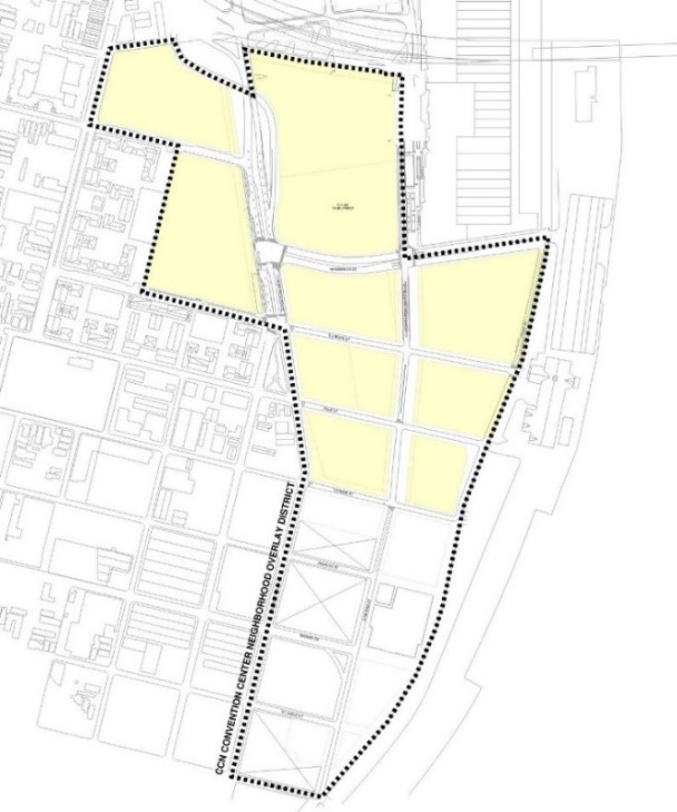
Adopted by Ord. 27,261 MCS, §1, Jan. 20, 2017, Zoning Docket 102-16; Ord. 29285 MCS, 1-5-23, ZD 64/22
18.24.B Development Plan, Neighborhood Participation, and Design Review Required
1. Development Master Plan Submittal
Prior to the issuance of any building permits for structures exceeding the base zoning district’s maximum height, a Development Master Plan shall address the general layout of the entire overlay area, including a plan for proposed structures and open space, traffic pattern plan, parking plan, and access points. The Development Master Plan shall include the following:
a. The location, square footage and building heights of all existing and proposed structures and uses intended.
b. A landscape plan for the area within the first twenty-five (25) feet of the lot boundaries. Landscape shall be in accordance with Article 23.
c. Stormwater management plan, including all on-site filtration and detention facilities. The plan shall be reviewed with consultation of the Department of Safety & Permits.
d. A perimeter sign plan for the area within the first twenty-five (25) feet of the lot boundaries. Signs shall be in accordance with Article 24.
e. A traffic plan shall include the following components: circulation routes for motor vehicle, bicycle and pedestrian transportation modes; ingress and egress locations for each transportation mode; curb side usage; locations and capacity of all off-street parking and loading spaces; traffic control during peak hours; and an inventory of way finding signage, pedestrian beacons, crosswalk striping, and ADA compliance shall be included. The City Planning Commission Executive Director shall consult with the Department of Public Works Director and the Regional Transit Authority on the traffic plan.
f. A traffic impact analysis, which shall include the traffic load impact on surrounding public street system. The City Planning Commission Executive Director shall consult with the Department of Public Works Director, the Port of New Orleans, and Convention Center representatives on required traffic impact analysis and implementation of recommendations for the area.
g. A plan for the stabilization of historic landmarks to avoid further deterioration and illegal access.
h. A phasing plan showing how Public Benefits will comply in the aggregate area of Article 18.24.A and the timing of construction to establish the compliance for each Public Benefit shown below:
i. open spaces;
ii. district-based stormwater management systems; and
iii. affordable housing.
i. A comprehensive parking plan.
2. Development plan and design review is required for any new structure, addition, or enlargement in accordance with the thresholds of applicability in Article 4.5. Additionally, any development that exceeds the base zoning district maximum building height or any Stadium or Convention Center conditional use shall be subject to Development Plan and Design Review Article 4.5 with mandatory Design Advisory Committee consideration based on a Development Master Plan submission.
3. Project Neighborhood Participation Program (Project NPP) Requirements
a. The following submittals for the CCN Overlay District shall only be accepted by the City Planning Commission after completion of a Project Neighborhood Participation Program (Project NPP), subject to the requirements specified in item 3.b and 3.c below:
i. Development Master Plan, as described in Article 18.24.B.1;
ii. Applications for construction that exceed eighty-five (85) feet in height, unless the proposed building was approved in the Development Master Plan and has undergone only minor changes, as defined in Article 4.5.F.1, in which case no additional NPP shall be required; and
iii. Applications for construction that exceed forty thousand (40,000) square feet of buildable area, unless the proposed building was approved in the Development Master Plan and has undergone only minor changes, as defined in Article 4.5.F.1, in which case no additional NPP shall be required.
b. The development plan submittal shall not be deemed complete for the purpose of a completeness review as provided in Article 3.2.B until all required Project NPP documents are submitted, including the meeting notice letter, sign-in sheets, and Project NPP meeting summary.
c. Applicants shall follow all Project NPP requirements, including all content and general procedures applicable to map and/or text amendments, as provided in Article 4.2.D.2, except with regard to mailed notice, which shall be as follows. Mailed notice for the NPP shall be sent by regular mail at least fifteen (15) days before the public hearing to the parties identified in Sectio 3.3.B.2, except that such notice shall be expanded to all properties within 1,200 (one thousand two hundred) feet of property lines of the subject property. Additionally, mailed notice shall be provided to the Lower Garden District and Warehouse District neighborhood associations, as well as the office of Community Development for distribution to interested stakeholders, including but not limited to residents of River Garden developments.
Adopted by Ord. 27,261 MCS, §1, Jan. 20, 2017, Zoning Docket 102-16; Ord. 29285 MCS, 1-5-23, ZD 64/22
18.24.C Permitted and Conditional Uses
Table 18-1 shall substitute and supersede the base zoning district’s Permitted and Conditional Uses found in Table 15-1. Only those land uses listed under Table 18-1 as Permitted or Conditional Uses are allowed within the CCN Overlay District. A “P” indicates that the use is permitted within that Overlay District. A “C” indicates that the use is a conditional use in that Overlay District and that a conditional use approval is required, in accordance with Article 4.3. In addition, the City Planning Commission and the Council decisions on applications for a conditional use shall evaluate the following factors, specific to the CCN Overlay District:
1. The proposed use is compatible with the CCN Overlay District's purpose to promote a walkable, mixed-use, and mixed-income neighborhood with public benefits.
2. The proposed use preserves and promotes public access to the CCN Overlay District, including sightlines and/or director access to the Mississippi Riverfront.
3. The proposed use does not create a material detriment to the public health, safety, and welfare to properties and residents within the CCN Overlay District, as well as neighbors in surrounding areas, including but not limited to the Lower Garden District, Warehouse District, and River Garden developments.
The absence of the use from the table indicates that use is prohibited within the Overlay District.
|
Table 18-1 Permitted and Conditional Uses
|
|
CCN Convention Center
Neighborhood Overlay District
|
P - Permitted Use,
C - Conditional Use
|
Use Standards
|
|
RESIDENTIAL USE
|
|
Bed and Breakfast - Accessory
|
P
|
Section 20.3.I
|
|
Bed and Breakfast - Principal
|
P
|
Section 20.3.I
|
|
Day Care Home, Adult - Small
|
P
|
Section 20.3.T
|
|
Day Care Home, Adult - Large
|
P
|
Section 20.3.T
|
|
Dwelling, Above the Ground Floor
|
P
|
|
|
Dwelling, Single-Family
|
P
|
|
|
Dwelling, Small Multi-Family Affordable
|
P
|
Section 20.3.SSS
|
|
Dwelling, Two-Family
|
P
|
Section 20.3.Y
|
|
Dwelling, Townhouse
|
P
|
Section 20.3.X
|
|
Dwelling, Multi-Family
|
P
|
|
|
Group Home, Small
|
P
|
Section 20.3.GG
|
|
Group Home, Large
|
P
|
Section 20.3.GG
|
|
Group Home, Congregate
|
C
|
Section 20.3.GG
|
|
Home Based Child Care, Small
|
P
|
Section 20.3.T
|
|
Home Based Child Care, Large
|
P
|
Section 20.3.T
|
|
Permanent Supportive Housing
|
P
|
Section 20.3.PP
|
|
Residential Care Facility
|
P
|
Section 20.3.YY
|
|
Short Term Rental, Large
|
P
|
Section 20.3.LLL
|
|
Short Term Rental, Small
|
P
|
Section 20.3.LLL
|
|
COMMERCIAL USE
|
|
Amusement Facility, Indoor
|
P
|
Section 20.3.E
|
|
Amusement Facility, Outdoor
|
P
|
Section 20.3.E
|
|
Art Gallery
|
P
|
|
|
Arts Studio
|
P
|
|
|
Animal Hospital
|
P
|
|
|
Auditorium
|
P
|
|
|
Bar
|
P
|
Section 20.3.G
|
|
Broadcast Studio
|
P
|
|
|
Bus Terminal
|
C
|
|
|
Car Wash
|
C
|
Section 20.3.L
|
|
Catering Kitchen
|
P
|
|
|
Check Cashing Establishment
|
P
|
Section 20.3.O
|
|
Child Care Center, Small
|
P
|
Section 20.3.S
|
|
Child Care Center, Large
|
P
|
Section 20.3.S
|
|
Cigar Bar
|
C
|
|
|
Convention Center
|
C
|
|
|
Day Care Center, Adult or Child - Small
|
P
|
Section 20.3.S
|
|
Day Care Center, Adult - Large
|
P
|
Section 20.3.S
|
|
Day Care Center, Adult - Commercial
|
P
|
Section 20.3.S
|
|
Drive-Through Facility
|
P1
|
Section 20.3.V
|
|
Financial Institution
|
P
|
|
|
Funeral Home
|
P
|
|
|
Greenhouse/Nursery
|
P
|
|
|
Gas Station
|
C
|
Section 20.3.EE
|
|
Grocery Store
|
P
|
|
|
Health Club
|
P
|
|
|
Hostel
|
P
|
|
|
Hotel/Motel
|
P/C5
|
|
|
Live Entertainment – Secondary Use
|
P
|
Section 20.3.JJ
|
|
Live Performance Venue
|
P
|
Section 20.3.JJ
|
|
Mardi Gras Den
|
P
|
|
|
Medical/Dental Clinic
|
P
|
|
|
Micro-Brewery
|
P
|
|
|
Micro-Distillery
|
P
|
|
|
Motor Vehicle Dealership, Small
|
P
|
|
|
Movie Studio
|
P
|
|
|
Office
|
P
|
|
|
Outdoor Amphitheater
|
C
|
Section 20.3.UUU
|
|
Outdoor Live Entertainment – Secondary Use
|
C
|
Section 20.3.VVV
|
|
Personal Service Establishment
|
P
|
|
|
Pet Day Care Service
|
P
|
Section 20.3.QQ
|
|
Printing Establishment
|
P
|
|
|
Public Market
|
P
|
Section 20.3.TT
|
|
Reception Facility
|
P
|
Section 20.3.WW
|
|
Recording Studio
|
P
|
|
|
Restaurant, Carry-Out
|
P
|
Section 20.3.ZZ
|
|
Restaurant, Fast Food
|
P
|
Section 20.3.ZZ
|
|
Restaurant, Standard
|
P
|
Section 20.3.ZZ
|
|
Restaurant, Specialty
|
P
|
Section 20.3.ZZ
|
|
Retail Goods Establishment
|
P
|
|
|
Retail Sales of Packaged Alcoholic Beverages
|
P
|
|
|
Short Term Rental, Commercial
|
P
|
Section 20.3.LLL
|
|
Small Box Variety Store
|
P
|
Section 20.3.NNN
|
|
Social Club or Lodge
|
P
|
Section 20.3.CCC
|
|
Stadium
|
C
|
|
|
Wine Shop
|
P
|
|
|
Winery
|
P
|
|
|
INDUSTRIAL USE
|
|
Brewery
|
P2
|
|
|
Distillery
|
P2
|
|
|
District Energy System
|
P
|
Section 20.3.QQQ
|
|
Food Processing
|
P
|
|
|
Manufacturing, Artisan
|
P
|
|
|
Manufacturing, Light
|
P
|
|
|
Mini-Warehouse (Self-Storage)
|
P
|
|
|
Research & Development
|
P
|
|
|
Warehouse
|
P
|
|
|
INSTITUTIONAL USE
|
|
Community Center
|
P
|
|
|
Convent and Monastery
|
P
|
|
|
Cultural Facility
|
P
|
Section 20.3.R
|
|
Educational Facility, Primary
|
P
|
Section 20.3.Z
|
|
Educational Facility, Secondary
|
P
|
Section 20.3.Z
|
|
Educational Facility, University
|
P
|
|
|
Educational Facility, Vocational
|
P
|
Section 20.3.Z
|
|
Emergency Shelter
|
C
|
Section 20.3.AA
|
|
Government Offices
|
P
|
|
|
Hospital
|
P
|
|
|
Hospitality Center
|
P
|
|
|
Place of Worship
|
P
|
|
|
Public Works & Safety Facility
|
P
|
|
|
Social Club or Lodge
|
P
|
Section 20.3.CCC
|
|
OPEN SPACE USE
|
|
Agriculture – No Livestock
|
P
|
Section 20.3.C
|
|
Parks and Playgrounds
|
P
|
|
|
Stormwater Management (Principal Use)
|
P
|
|
|
OTHER
|
|
Parking Structure (Principal Use)
|
P
|
Section 20.3.OO
|
|
Planned Development
|
C
|
Article 5
|
|
Pumping Station
|
P
|
Section 20.3.UU
|
|
Utilities
|
P3
|
Section 20.3.GGG
|
|
Wireless Telecommunications Antenna & Facility
|
C, P4
|
Section 20.3.JJJ
|
|
Wireless Telecommunications Tower & Facility
|
C
|
Section 20.3.JJJ
|
1. Drive-through facilities in the CCN Overlay District are allowed as permitted uses where they are proposed to be constructed in combination with either a financial institution or a retail goods establishment in order to provide or dispense medical or pharmaceutical products. Drive-through facilities in the CCN Overlay District shall be located behind structures out of view from the public right-of-way.
2. Only breweries and distilleries that produce fewer than 12,500 barrels per year are considered permitted uses.
3. Electrical Utility Substations and Transmission Lines shall be subject to design review as per Article 4, Section 4.5.B.5 and Table 4-2.
4. Only wireless telecommunications antennas that comply with the stealth design standards of Section 20.3.JJJ are considered permitted uses.
5. Hotels shall be considered permitted if they:
(1) are located on the same square as a cultural facility of at least 10,000 square feet in size; or
(2) have less than 180 individual guest rooms and are located at least 300 feet from any residential zoning district, as measured from the closest lot line.
Hotels shall be prohibited if:
- There is already one (1) hotel permitted on the square; or
- They are within the square bounded by Annunciation, Melpomene, Euterpe, and Tchoupitoulas Streets (exculding Lot MF-1), or the square bounded by Thalia, Annunciation, Melpomene, and Tchoupitoulas Streets.
All other hotels shall be a conditional use.
Adopted by Ord. 27,261 MCS, §1, Jan. 20, 2017, Zoning Docket 102-16; Ord. 29285 MCS, 1-5-23, ZD 64/22
18.24.D Site Design Standards
Adopted by Ord. 27,261 MCS, §1, Jan. 20, 2017, Zoning Docket 102-16; Ord. 29285 MCS, 1-5-23, ZD 64/22
18.24.D.1 Bulk and Yard Regulations
Bulk and Yard Regulations for the CCN Overlay District shall be as provided in Table 18-2.
Table 18-2: Bulk and Yard Regulations
|
TABLE 18-2: BULK REGULATIONS
|
|
MINIMUM LOT AREA PER
DWELLING UNIT
|
None
|
|
MAXIMUM BUILDING HEIGHT
|
See 18.24.D.6 Maximum Building Height and Table 18-3.
|
|
MINIMUM PERMEABLE OPEN SPACE
|
Calculated as aggregate; 20% of the area as defined within 18.24.A.2.1 Other areas within the CCN Overlay District are subject to the permeable open space requirement of the base zoning district.
|
|
MINIMUM YARD REQUIREMENTS
|
|
FRONT YARD
|
a. For the lots bounded by Henderson Street, Convention Center Boulevard, Orange Street, and Front Street, the minimum is 30’ and maximum is 50’ abutting Convention Center Boulevard.
b. For the lots bounded by Henderson Street, Convention Center Boulevard, Orange Street, and Tchoupitoulas Street, the minimum is 15’ and maximum is 25’ abutting Convention Center Boulevard.
c. The minimum is 12’ and maximum is 22’ for lots abutting Euterpe Street, Race Street, and Orange Street.
d. All other lots: None.
|
|
INTERIOR SIDE YARD
|
All other lots: None, unless abutting a residential district then 5'.
|
|
CORNER SIDE YARD
|
None.
|
|
REAR YARD
|
None, unless abutting a residential district then 20'.
|
TABLE 18-2 FOOTNOTES
1 Developments subject to this section include projects undertaken in phases, stages, or otherwise developed in distinct sections or lots. If the development contains a phasing plan, the phasing plan shall provide for the minimum permeable open space as required within this section, calculated as aggregate of the area defined within 18.24.A.2.
18.24.D.2 Required On-Site Public Open Space
To establish publicly accessible open space, the following standards in subsection “a.” shall apply to the areas described in subsections b and c below:
a. Public Park and Plaza
- Parks or plazas shall be open to the sky, except for arbors, trellises or small pedestrian-oriented structures.
- Parks or plazas shall have a minimum site area of two-thousand five-hundred (2,500) square feet per square.
- At least twenty percent (20%) of the park or plaza shall consist of landscaping.
- A minimum of one (1) linear foot of seating area shall be provided for each thirty (30) square feet of park or plaza.
- All parks or plazas shall be visible from and connected to the nearest sidewalk with preference given to corner locations that maximize pedestrian access.
- Parks or plazas shall be designed in accordance with ADA accessibility requirements. No plaza may be more than three (3) feet above the adjacent sidewalk level.
- Parks or plazas shall be open to the public at minimum during the hours of 8:00 a.m. to 9:00 p.m. daily. A plaque two (2) feet by four (4) feet in area shall be displayed at all entrances stating the hours of public use unless the park or plaza is open 24 hours per day.
- Plazas shall be located so that they receive natural light during a portion of the day.
b. For the properties bounded by Henderson Street, Convention Center Boulevard, Orange Street, and Tchoupitoulas Street, a minimum of two-hundred (200) feet of the street frontage along Convention Center Boulevard shall exceed the maximum Front Yard Requirement as defined within Table 18-2: Bulk and Yard Regulations to provide publicly accessible open space with amenities such as, but not limited to, landscaped public open space, public art, mural, dog park, transit shelter, public rooftop access, outdoor seating of a restaurant, or public plaza subject to the Public Plaza Standards and Guidelines contained within Article 18.24.D.2.a.
c. For the properties bounded by Henderson Street, Convention Center Boulevard, Orange Street, and Front Street, the Front Yard along Convention Center Boulevard shall be publicly accessible open space with amenities such as, but not limited to, landscaped public open space, public art, mural, dog park, transit shelter, public rooftop access, outdoor seating of a restaurant, or public plaza.
18.24.D.3 Design Standards
The following design standards only apply to development within the area denoted in Article18.24.A.2, as illustrated in Figure 18-6. The design standards in this section shall take the place of the building design standards under Article 15.3.B. All other parcels within the CCN Overlay District shall be governed by the base underlying zoning design standards and applicable overlay district standards.
a. Pedestrian and main entrances shall be located on the public right-of-way. Public entrances shall be articulated and distinct from the structures primary massing. Unless deemed and ruled as unfeasible, curb cuts shall be located on the secondary streets.
b. Ventilation grates, emergency exit doors, and similar functional elements shall be designed as decorative elements and integrated into the overall building design.
c. Security bars are prohibited. Roll-up or accordion security grilles are permitted on the ground floor when constructed of a see-through, non-solid material. The casing shall be painted to match the building and shall not damage or obscure architectural detailing.
d. Plain mansard roofs are prohibited. Decorative mansard roofs are permitted on buildings with a minimum wall height of two (2) stories. (See Figure 15-2: Examples of Decorative Mansard Roofs).
e. Buildings shall be designed with galleries, awnings, canopies, and other weather protection devices.
f. Decorative elements having historically functional purposes, such as shutters, balconies, windows, and doors, shall be operational.
g. Any structure designed for a ground floor non-residential use shall be designed with a minimum ceiling height of twelve (12) feet, except for parking areas.
h. Loading areas for retail anchor stores of twelve thousand (12,000) square feet in gross floor area or more are required to be located in the rear. Where possible, loading and service areas shall be internal to the development block and accessed through service corridors and not through pedestrian-oriented streets.
i. Outlot buildings shall be designed with showcase windows and entrances oriented to the street.
j. Secondary access points are encouraged from rear parking lots. Facades that abut parking areas and contain a public entrance shall include pedestrian walkways.
k. When a shopping center is located behind a parking lot, a street presence for the shopping center shall be created by locating part of the center and/or outlot buildings near the lot line at the primary street corner or the shopping center entrance. When the center’s frontage on the primary street exceeds two-hundred fifty (250) feet in width, part of the center and/or outlot buildings shall hold at least fifty percent (50%) of the front lot line. (See Figure 15-3: Building Siting).
l. The following building materials are prohibited on exterior elevations visible from the public right-of-way. However, such materials may be used as part of decorative or detail elements, or as part of the exterior construction that is not used as a surface finish material.
1. Exterior insulating finish systems (EIFS)
2. Stuccato Board
3. Vinyl Siding
m. The site shall be designed to ensure safe pedestrian access to the building from the street and from any parking areas. Safe pedestrian access to and from adjacent buildings is also required. Sidewalks shall extend to the lot line and connect to existing sidewalks on abutting properties.
n. Within any yards of the development and the public right-of-way adjacent to the development, special finishes shall be included as part of a cohesive streetscape design. These include coordinated paving, design treatments for the pedestrian level, street lighting, and street furniture. The streetscape design shall be coordinated with the building design.
o. Off-street vehicle parking shall be set behind structures whenever possible.
p. Curb cuts shall be limited along transit lines to greatest extent feasible.
q. View corridors from streets that are generally perpendicular to the River shall be maintained.
18.24.D.4 Affordable Housing
a. A minimum of ten percent (10%) of total housing units shall be affordable housing units in accordance with Article 28.3 Affordable Housing Development Use Standards and Guidelines and may be calculated as aggregate in the area described in Article 18.24.A.2.
b. For rental projects, the affordable units in an Affordable Housing Development shall be rented to families earning no more than 60% of the Area Median Income (AMI).
c. In the aggregate area described in Article 18.24.A.2, the Article 28.6 Payment In-Lieu Fee option shall not apply.
d. Affordable housing units shall be subject the Affordable Housing Development Design Article 28.4.B through 28.4.D and shall be subject to Article 28.8 Compliance and Monitoring.
1. The affordable housing units shall be comparable to the market-rate dwelling units in terms of floor area and exterior finishes. Interior finishes or appliances may be different if functionality and longevity are retained.
2. The residents of the affordable housing units shall have access to the same amenities as the residents of the market-rate dwelling units.
3. Affordable units shall utilize the same entrances as market-rate units and shall not have separate entrances.
4. The bedroom mix (i.e., the number of bedrooms) of the affordable housing units shall be proportional to the market-rate dwelling units.
e. An additional ten percent (10%) of total housing units shall be workforce housing and rented to families earning no more than one hundred twenty percent (120%) of the Area Median Income (AMI).
18.24.D.5 Traffic Impact Analysis
The City Planning Commission Executive Director shall require a traffic impact analysis and compliance with the recommendations therein for any Stadium or Convention Center conditional use, any new structure, or major renovation exceeding the base zoning district’s maximum building height and not covered by an approved Development Master Plan. The City Planning Commission Executive Director may require further Traffic Impact Analyses or Traffic Plans based on changes to the proposed uses or development plan. The Traffic Impact Analysis shall be approved by the City Planning Commission Executive Director after consultation with the Department of Public Works Director.
18.24.D.6 Maximum Building Height
a. In lieu of the base zoning district regulations, maximum building height shall be established by Table 18-3. Some squares are identified by their planned bounding streets because square numbers may change due to re-subdivision. Figure 18-7 is shown with corresponding height limits for reference; however, Table 18-3 shall control.
b. In squares along Tchoupitoulas Street, the maximum building height of Table 18-3 shall be achieved by line-of-sight from the opposite side of Tchoupitoulas Street methodology established in Figure 18-8 over the base zoning district’s 85 ft. height limit.
|
TABLE 18-3: MAXIMUM BUILDING HEIGHT
|
|
Square
|
Maximum Building Height
|
|
Square bounded by: Convention Center Boulevard, Calliope, Henderson, and Tchoupitoulas Streets
|
200 feet
|
|
Square bounded by: Thalia, Annunciation, Melpomene, and Tchoupitoulas Streets
|
85 feet and no more than 7 stories
|
|
Square bounded by: Annunciation, Melpomene, Euterpe and Tchoupitoulas Streets (but excluding Lot MF-1)
|
85 feet and no more than 7 stories
|
|
Square bounded by: Convention Center Boulevard, Henderson, Euterpe, and Tchoupitoulas Streets
|
85 to 400 feet, subject to the line-of-sight setbacks shown in figure 18-8
|
|
Square bounded by: Convention Center Boulevard, Henderson, Euterpe, and Front Streets
|
400 feet
|
|
Square bounded by: Convention Center Boulevard, Race, Euterpe and Tchoupitoulas Streets
|
85 to 400 feet, subject to the line-of-sight setbacks shown in figure 18-8
|
|
Square bounded by: Convention Center Boulevard, Race, Euterpe and Front Streets
|
400 feet
|
|
Square bounded by: Convention Center Boulevard, Race, Orange, and Tchoupitoulas Streets
|
85 to 400 feet, subject to the line-of-sight setbacks shown in figure 18-8
|
|
Square 39 bounded by: Orange, Richard, S. Peters, and Tchoupitoulas Streets
|
85 to 125 feet, subject to the line-of-sight setbacks shown in figure 18-8
|
|
Squares 21-B and 22-B: bounded by: the floodwall, Orange, Market, and S. Peters Streets
|
21-B: 400 feet
22-B: 200 feet
|
|
Square 23-B: bounded by: the floodwall, Market, S. Peters, and St. James Streets
|
125 feet
|
|
Square 38 bounded by: Market, Richard, S. Peters, and Tchoupitoulas Streets
|
85 to 125 feet, subject to the line-of-sight setbacks shown in figure 18-8
|
|
Square 36 bounded by: Market, St. James, S. Peters, and Tchoupitoulas Streets
|
85 to 125 feet, subject to the line-of-sight setbacks shown in figure 18-8
|
|
Square 35 bounded by: Celeste, St. James, S. Peters, and Tchoupitoulas Streets
|
85 to 125 feet, subject to the line-of-sight setbacks shown in figure 18-8
|
|
Square 24B bounded by: the extension of St. James Street, S. Peters Street, and the floodwall
|
85 feet and no more than 7 stories
|
c. A height of up to one hundred seventy-five (175) feet shall be allowed for transparent protective screening (fencing) including poles and other necessary structural elements encompassing the perimeter of outdoor amusement or sports facilities for public safety purposes.
Figure 18-7: Maximum Building Height - Perspective
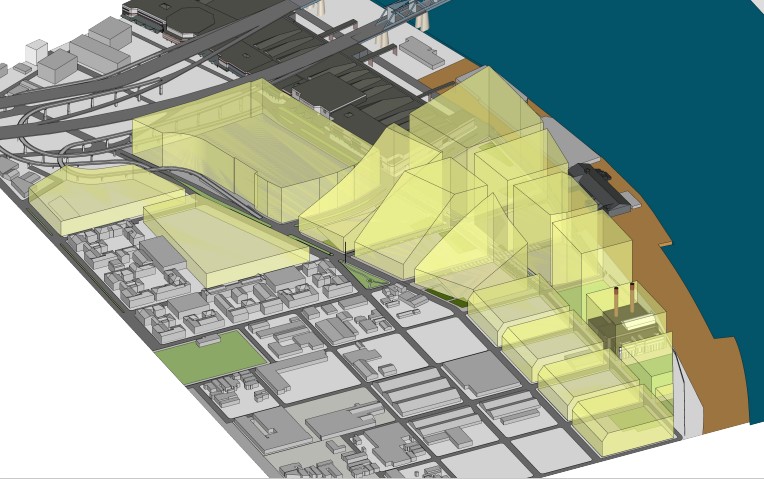
Figure 18-8: Tchoupitoulas Street Line-of-Sight
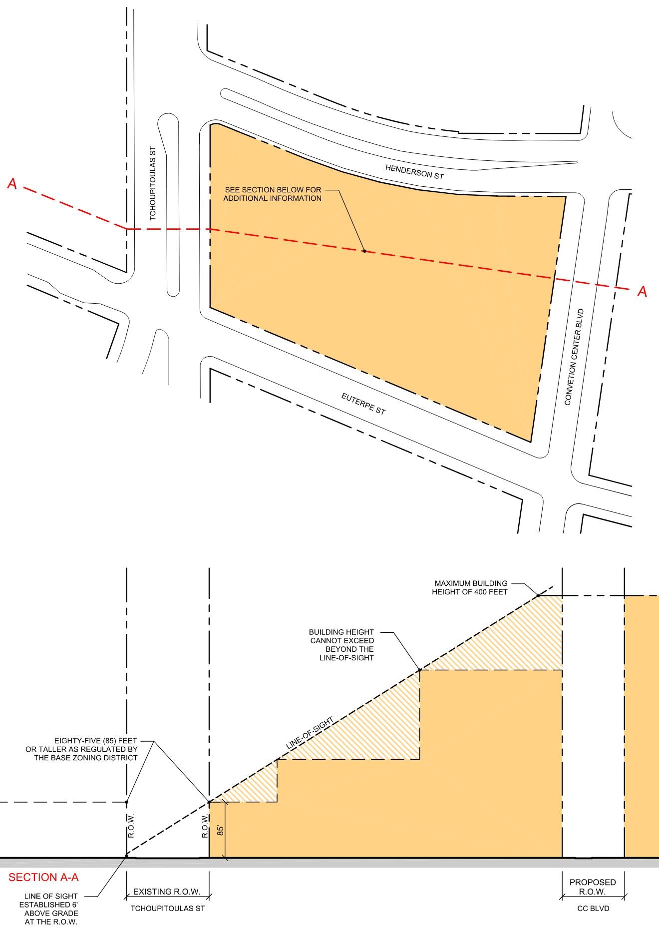
18.24.D.7 Parking
The Convention Center Neighborhood Overlay District is exempt from the vehicle parking requirements of Table 22-1. Notwithstanding this exemption, accessory parking lots may be provided in accordance with the Maximum Vehicle Parking Limitations of Article 22.4.B as if off-street vehicle parking is required.
Additional temporary surface parking shall be permitted subject to time restrictions up to 5 years. Permanent parking lots shall be subject to the standards of the Overlay District and Article 23 of the Comprehensive Zoning Ordinance, while certain design standards for temporary parking lots may be suspended commensurate with the time restrictions as set forth by the City Planning Commission and approved in the Development Master Plan.
18.25 SBA St. Bernard Avenue Overlay District
Adopted by Ord. No. 27,459, §1, July 20, 2017, Zoning Docket 35/17
18.25.A Applicability
The SBA St. Bernard Avenue Overlay District is intended to create density allowances for sites maintaining frontage along St. Bernard Avenue while also reducing the parking requirement for Residential Care Facilities.
- The SBA St. Bernard Avenue Overlay District applies to all properties that allow multi-family development and Residential Care Facilities on blocks with frontage on St. Bernard Avenue from the I-10 overpass/North Claiborne Avenue to North Dorgenois Street that require Article 4, Section 4.5 Development and Design Review approval.
Adopted by Ord. No. 27,459, §1, July 20, 2017, Zoning Docket 35/17
18.25.B Density Bonus for SBA St. Bernard Avenue Overlay District
In the establishment and authorization of a development in the SBA St. Bernard Avenue Overlay District, the following provides the baseline for determining whether a project qualifies for a development bonus. The project may be awarded a maximum of thirty percent (30%) reduction in the minimum lot area per dwelling unit requirements.
- The development provides an affordable housing component on-site. Affordable housing shall be evenly distributed throughout the project, and shall be comparable to market-rate units in size, bedroom mix, and exterior finishes. A qualifying project is entitled to a development bonus if it meets one (1) of the following thresholds and maintains affordability for a period of at least fifty (50) years:
- Five percent (5%) of units aside at thirty percent (30%) AMI should yield a fifteen percent (15%) reduction in the minimum lot area per dwelling unit requirements.
- Five percent (5%) of units aside at fifty percent (50%) AMI should yield a ten percent (10%) reduction in the minimum lot area per dwelling unit requirements.
- Five percent (5%) of units aside at eighty percent (80%) AMI should yield a five percent (5%) reduction in the minimum lot area per dwelling unit requirements.
The development bonuses provided in items a., b., and c. above may be combined to provide a total bonus of up to 30%. All affordable housing provided pursuant to this section shall comply with the Affordable Housing Standards and Guidelines provided in Section 17.5.H.2, except where such standards conflict with the provisions of this section.
Adopted by Ord. No. 27,459, §1, July 20, 2017, Zoning Docket 35/17
18.25.C Additional Density Bonus for SBA St. Bernard Overlay District
Residential Care Facility projects providing affordable senior housing located within the SBA St. Bernard Overlay District and exceeding the baseline density bonus as stated above in Section 18.25.B, may be awarded an additional thirty percent (30%) reduction for a maximum of sixty percent (60%) reduction in the minimum lot area per dwelling unit requirements and may also receive a maximum height allowance of fifty-five feet (55').
- The development provides an affordable senior housing component in a Residential Care Facility on-site. Affordable senior housing shall be evenly distributed throughout the project, and shall be comparable to market-rate units in size, bedroom mix, and exterior finishes. A qualifying project is entitled to a development bonus if it meets the thresholds in Section 18.25.B, the following threshold, and maintains affordability for a period of at least fifty (50) years.
- Projects providing more than fifty percent (50%) of units aside at sixty percent (60%) or less AMI should yield a sixty percent (60%) reduction in the minimum lot area per dwelling unit requirements and a maximum height allowance of fifty-five feet (55').
Adopted by Ord. No. 27,459, §1, July 20, 2017, Zoning Docket 35/17
18.25.D Reduced Off-Street Parking Allowance
Residential Care Facility projects providing affordable senior housing and meeting the Density Bonus thresholds outlined in sections 18.25.B and 18.25.C shall be required to provide a minimum of .25 off-street parking spaces per dwelling unit.
Adopted by Ord. No. 27,459, §1, July 20, 2017, Zoning Docket 35/17
18.26 MIDDLE HARRISON USE RESTRICTION OVERLAY DISTRICT
Adopted by Ord. No. 27,665, §2, February 8, 2018, Zoning Docket 097/17;
18.26.A APPLICABILITY
The Middle Harrison Use Overlay District applies to the following areas:
- Those lots in Lakeview that front on Harrison Avenue between Canal Boulevard and West End Boulevard.
Adopted by Ord. No. 27,665, §2, February 8, 2018, Zoning Docket 097/17; Ord. No. 27,961, §1, December 27, 2018, Zoning Docket 113/18;
18.26.B USE RESTRICTIONS
1. Any use, or the aggregate of uses, over four thousand (4,000) square feet in gross floor area on one lot is prohibited.
2. Maximum number of Standard Restaurants shall remain at five (5).
3. All standard restaurants are conditional uses.
4. Allow only one restaurant (of any type) in each 100 block (restaurants facing Canal Boulevard and West End Boulevard would count to that 100 block of Harrison).
**All six (6) restaurants presently operating and all five (5) restaurants in the 500 and 600 blocks of Harrison Avenue shall be grandfathered at their present location of operation.
5. Specialty Restaurants shall be a maximum of 1,250 square feet.
6. Specialty/Carryout/Fast Food Restaurants shall not serve alcohol for consumption on premises or be sold as packaged.
7. The following uses are prohibited: gas station, motor vehicle repair, minor, fast food restaurant, alcoholic beverage sales in a specialty restaurant, and bar.
Use Standards
- No music shall be allowed to be played at a business that is audible outside and/or have external speakers.
- Signs advertising the business shall not be allowed as monument signs on front lawns but must be attached to the front of the building to not block sight lines of side streets and alley ways exiting onto Harrison Avenue.
- Restaurants shall not open for business before 7:00 a.m. or seat new customers after 9:00 p.m.
- Buildings must have a 5 ft. setback from the sidewalk, with the area landscaped to be used as green space only.
- Deliveries and trash between 10:00 p.m. and 7:00 a.m. is prohibited.
Adopted by Ord. No. 27,665, §2, February 8, 2018, Zoning Docket 097/17; Ord. No. 27,961, §1, December 27, 2018, Zoning Docket 113/18; Ord.28328 MCS, 4-15-20, ZD 115/19
18.27 Coronet Court Multi-Family Housing Overlay District
18.27.A Applicability
1. Those lots generally bounded by Lake Forest Boulevard, Mayo Road, the Interstate 10 Service Road and the Lawrence Canal.
Adopted by Ord. 28479 MCS, 9-3-20, ZD 42/20
18.27.B Uses
18.27.B.1 Permitted Uses
In addition to all uses authorized in the base district the following uses are permitted uses subject to the use standards of Article 20:
a. Dwelling, Established Multi-Family
b. Dwelling, Established Townhouse
18.28 ALGIERS RIVERFRONT USE AND HEIGHT RESTRICTION OVERLAY
18.28.A Applicability
The restrictions contained herein shall apply to all lots within the following boundaries: from the Mississippi River at the Orleans/Jefferson Parish line to Brooklyn Avenue, the along Brooklyn Avenue to Powder Street, Powder Street to the top of the levee, continuing along the levee to Morgan Street, continuing along Morgan Street until Patterson Road, continuing in the downriver direction along the Patterson Street right-of-way to the Bermuda Street right-of-way, and from the Bermuda Street right-of-way north to the Mississippi River.
Adopted by Ord. 28676 MCS, ZD 3/21, 5-20-21
18.28.B Uses
18.28.B.1 Prohibited Uses
a. Where otherwise permitted in the base zoning, the following use is prohibited:
1. Gas Station.
b. Where otherwise permitted in the base zoning, the following uses require conditional use approval by the City Council:
1. Bar.
2. Check Cashing Establishment
3. Motor Vehicle Service Repair, Minor
4. Small Box Variety Store
18.28.C. Building Design Limitations
The following building design standards and requirements shall apply to any new structure, major renovation, or expansion within the boundaries of the Algiers Riverfront Use and Height Overlay District, without regard to its use:
a. Except as provided in Subsection b, the height shall be limited to sixty (60) feet and no more than five (5) stories, and the density as provided in the base zoning district, unless the building meets the standards described in Article 18, Section 18.13.G.
b. For properties with street frontage located along Brooklyn Avenue between Opelousas Avenue and Socrates Street, including lots that front the following streets that intersect with Brooklyn Avenue: Opelousas, Slidell Street, Homer, Newton, Diana, LaMarque, Socrates, Ptolemy, and Lawrence Streets - the height shall be limited to forty (40) feet and no more than three (3) stories, and the density as provided in the base zoning district, unless the building meets the standards described in Article 18, Section 18.13.G.
1. Such properties are permitted a maximum building height of forty (40) feet with a maximum height of three (3) stories along the Brooklyn Avenue frontage.
2. Any additional height above forty (40) feet, obtained through the height bonus provided in Article 18, Section 18.13.G, shall be set back from the front property line at Brooklyn Avenue at a minimum distance of one (1) foot for every one (1) foot in height, up to a maximum of sixty (60) feet and five (5) stories.
c. Flat roofed structures shall provide an adequately-sized parapet in order to mitigate the sight of rooftop equipment.
d. Where provided as accessory flat roof features, open spaces located on roofs shall be excluded from the calculation of building height and gross floor area in accordance with Section 21.6.O.
18.29 FRENCH MARKET OVERLAY DISTRICT
18.29.A AREA OF APPLICABILITY
The area generally bounded by the riverside of Decatur Street, the downriver side of St. Peter Street (and its direct extension to the Mississippi River), the Mississippi River, the upriver side of Barracks Street (and its direct extension to the Mississippi River), French Market Place, and Ursulines Street.
18.29.B PUBLIC MARKET HOURS
The hours of operation of the existing Public Market (commonly known as the French Market Flea and Farmers Market) shall be expanded to permit a morning seafood and/or produce market beginning at 4:00 a.m., and to permit evening market closing hours at 10:00 p.m. on Sundays through Thursdays and 11:00 p.m. on Fridays and Saturdays. There shall be no live entertainment indoors or outdoors after 8:00 p.m. on any day.
18.29.C PERMITTED SIGNAGE
The following sign types are permitted within the French Market Overlay District:
1. Freestanding Multi-Tenant Monument signs shall be permitted, subject to the following standards:
a. One (1) Freestanding Multi-Tenant Monument Sign shall be permitted per building, to be located within breezeways between existing commercial structures.
b. No portion of the sign shall project beyond the front building wall of any existing commercial structure, where the structure’s front wall is adjacent to the public right-of-way, except at the Governor Nicholls Street breezeway between the farmers and flea markets, where no portion of the sign shall project beyond the roof line of the existing market shed structures.
c. These signs shall be limited to a maximum of six (6) feet in height. The area of each sign shall be limited to twenty-four (24) square feet.
d. A map of the area described above (the boundaries of the French Market Overlay District) may be included on the sign.
e. Tenant listing shall be limited to the name of the business and address. All listings shall be the same size.
f. The design and location of the signs shall be subject to the review and approval of the French Market Corporation and the staff of the Vieux Carré Commission.
g. The design and location of the signs shall be proposed by the French Market Corporation and shall be subject to the review and approval of the Vieux Carré Commission staff.
5. In lieu of the permitted Freestanding Multi-Tenant Monument Sign, where applicable, multi-tenant signs identifying individual tenant space shall be permitted to be co-located on an approved communications antennae installation, located within breezeways between buildings at St. Ann, Dumaine, St. Philip, and Governor Nicholls Streets, subject to the following standards:
a. One grouping of multi-tenant signs shall on a singular communications antenna shall be permitted per breezeway. The total square footage of signage on the antennae shall not exceed eight (8) square feet.
b. The design and location of the signs shall be proposed by the French Market Corporation and shall be subject to the review and approval of the Vieux Carré Commission staff.
6. Attached Permanent Directory Signs shall be permitted, subject to the following standards:
a. Attached Permanent Directory Signage shall only be permitted at the Public Market in the area generally bounded by Decatur, Barracks, N. Peters and Ursulines Streets.
b. One Attached Permanent Directory Sign shall be permitted per street frontage.
c. The sign area of each sign shall be limited to twelve (12) square feet.
d. The design and location of the signs shall be proposed by the French Market Corporation and shall be subject to the review and approval of the Vieux Carré Commission staff.
Adopted by Ord. 28713 MCS, 7-1-21, ZD 23/21
18.30 University Area Off-Street Parking Overlay District
18.30.A Applicability
Properties in the area generally bounded by: Cecil Street to Monticello Avenue, Monticello Avenue, to Leake Avenue, to River Drive, to Riverview Drive, to East Drive, to Tchoupitoulas Street, turning south on State Street, turning east on Front Street, turning north on Nashville Avenue, turning east on Tchoupitoulas Street, turning north on Jefferson Avenue, turning east on South Claiborne Avenue, turning north on Toledano Street, connecting to Washington Avenue, turning west on Earhart Boulevard, turning north on South Carrollton Avenue, turning west on Tulane Avenue/Airline Highway connecting to Palmetto Street, to Northline Street, to Monticello, to Cecil Street. Within this are, only properties zoned HU-RS Historic Urban Single-Family Residential, HU-RD1 Historic Urban Two-Family Residential, HU-RD2 Historic Urban Two-Family Residential, HU-RM1 Historic Urban Multi-Family Residential and HU-RM2 Historic Urban Multi-Family Residential Districts are subject to the University Area Off-Street Parking Overlay District's requirements.
Adopted by Ord. 28848 MCS, 11-18-21, ZD 44/21; Ord. 29761 MCS, 12-14-23, ZD 45/23
18.30.B Off-Street Parking Requirements
The university area off-street parking overlay requirements are as follows:
1. One (1) off-street parking space is required per new bedroom. "Bedroom" shall be defined as an enclosed private room that includes an operable window and a door that opens to a space other than another bedroom, bathroom, half-bath or toilet room.
a. A bedroom shall be considered an "existing bedroom" if the bedroom has historically been used as such and meets all bedroom requirements contained within this section, as determined by the Department of Safety and Permits. When there is contradictory or conflicting evidence, ambiguity and/or confusion as to the number of existing bedrooms, the question of the number of existing bedrooms shall be resolved in favor of the more restrictive interpretation and regulation.
b. A "proposed new additional bedroom" is any enclosed private room shown on plans for new construction and proposed renovations, that is not an existing bedroom, that is not a kitchen or bath, and that is not a non-enclosed area such as a common room or pass-through room as described within this section. All enclosed private rooms shown on any proposed plans are presumed to be bedrooms.
c. Every existing bedroom and proposed new additional bedroom in a dwelling unit must be an enclosed private room and must not be a non-enclosed common room or pass-through room. A pass-through room is a space or room with multiple doors that is primarily used for passage from one room or space to another in a dwelling unit.
d. Every existing bedroom and proposed new additional bedroom in a dwelling unit shall contain a minimum of seventy (70) square feet of floor area, and every bedroom intended for occupancy by more than one person shall contain a minimum of fifty (50) square feet of floor area per occupant.
e. In the case of a shotgun-style dwelling units with pass-through rooms, for the purposes of this Ordinance and calculating the required off-street parking spaces, the number of existing and proposed new additional bedrooms shall be the number of rooms remaining after excluding a common room, a kitchen, and bathrooms.
f. All restrictions, limitations and requirements contained in this overlay, including but not limited to those concerning existing and proposed new additional bedrooms in a dwelling unit, are in addition to restrictions, rules and requirements provided for elsewhere in the CZO, the City Code, the Building Code, Louisiana Law or any other applicable law or ordinance.
2. This off-street parking requirement shall apply to new construction, and any renovations of existing structures that result in an increase in existing bedrooms or bathrooms, as determined by the Department of Safety and Permits.
a. All structural renovation permit applications within the boundaries of this overlay that include alterations of additions to the structure's footprint shall include a recent survey of the property that shows all structures, fences, setbacks, and any existing nonconformities.
3. This off-street parking requirement shall not apply to new construction dwelling units with three (3) or fewer bedrooms, or renovations of existing dwelling units where the total number of bedrooms is three (3) or fewer as determined by the Department of Safety and Permits.
4. Any increase in bathrooms where the total number is more than two full and one half (2.5) per dwelling unit shall be prohibited in this overlay, as determined by the Department of Safety and Permits.
5. "Full Bathroom" shall be defined as an enclosed room with plumbing for a bathtub and/or shower. "Half Bathroom" shall be defined as an enclosed room with plumbing for a sink and toilet.
6. All new construction dwelling units or renovations to existing structures must include a non-enclosed common room or area containing a minimum of 120 square feet which cannot be used as a bedroom; or a minimum of 200 square feet if the non-enclosed common room includes a kitchen.
a. A common room is any non-enclosed room or space that is primarily used for non-private or communal purposes, including but not limited to living rooms and dining rooms, and any pass-through rooms used for transiting from one room to another. A non-enclosed common room or pass-through room shall not be a bedroom, and an enclosed private room shall not be a common room or pass-through room.
7. This off-street parking requirement shall only apply to properties zoned HU-RD1, HURD2, HU-RS, HU-RM1, and HU-RM2 as determined by the City Planning Commission and the Department of Safety and Permits.
8. All residentially-zoned properties with a homestead exemption shall be exempt from this overlay.
9. This off-street parking requirement shall not apply to any residential Affordable Housing development, as determined by the Department of Safety & Permits, that meets the following criteria:
a. Any affordable housing development must set aside 50% of all units at 60% AMI or below.
b. Each affordable unit must have an affordability period of 20 years.
c. Any affordable housing development must have a covenant or deed restriction limiting the future sales price of each affordable unit to the initial sales price plus 5% for the entire 20-year affordability period. This covenant or deed restriction must be disclosed to prospective buyers.
10. Each additional parking space, as required by this overlay, must be a permeable surface as defined in Section 26.6 in the Comprehensive Zoning Ordinance under Permeable Paving.
11. Each additional parking space, as required by this overlay, must be a minimum of 8.5 feet wide by 18 feet long, and be otherwise compliant with all requirements in Section 22.11.D of the Comprehensive Zoning Ordinance.
12. Tandem parking is prohibited and shall not be counted toward existing or required new additional parking spaces.
13. New construction dwelling units and renovations to existing structures shall not be raised to accommodate required off-street parking underneath the structures.
14. Waivers of these off-street parking requirements restrictions may be considered by the Board of Zoning Adjustments.
15. Consistent with the stated purpose of preserving the neighborhoods' residential character, existing housing types, and levels of affordability and limiting the conversion of existing housing into short-term housing, the Department of Safety and Permits, when applying this overlay, shall not be bound by the characterizations contained on submitted plans when calculating the number of bedrooms and bathrooms and shall scrutinize unusually large spaces designated as halls, closets, and other non-private, common rooms to ensure that the purposes of the overlay are not frustrated.
16. Should any section, paragraph, sentence, clause, phrase or word of this overlay be declared invalid or unconstitutional by a court of competent jurisdiction, such invalidity or unconstitutionality shall not affect any of the remaining words, phrases, clauses, sentences, or paragraphs of this overlay, as they would have been enacted by the City Council without the incorporation of any such invalid or unconstitutional word, phrase, clause, sentence or paragraph.
17. This overlay shall be reconsidered in 2026 provided that the City Council has not otherwise initiated a zoning text amendment as permitted by Section 18.1.A and in accordance with the process in Section 4.2.
Adopted by Ord. 28848 MCS, 11-18-21, ZD 44/21; Ord. 29761 MCS, 12-14-23, ZD 45/23
18.31 Brown's Dairy Neighborhood Overlay District
Adopted by Ord. 29577, 8-16-23, Zoning Docket 41/23
18.31.A Applicability
The Brown's Dairy Neighborhood Overlay District applies to the following areas:
- Those lots generally bounded by Erato Street, Baronne Street, Martin Luther King, Jr. Boulevard, and Carondelet Street.
Adopted by Ord. 29577, 8-16-23, Zoning Docket 41/23
18.31.B Uses
Adopted by Ord. 29577, 8-16-23, Zoning Docket 41/23
18.31.B.1 Prohibited Uses
a. Where otherwise permitted in the base zoning district, the following use is prohibited:
- Bed and Breakfast Accessory
- Bed and Breakfast Principal
- Hostels
- Hotels/Motels
- Commercial Short Term Rental
- Non-Commercial Short Term Rental
Adopted by Ord. 29577, 8-16-23, Zoning Docket 41/23
18.32 University Area Design Overlay District
Adopted by Ord. 29882, April 5, 2024, Zoning Docket 089/23
18.32.A Applicability
New residentially-zoned structures, or major renovations or expansions of residentially-zoned structures located in the University Area, that being the area generally bounded by South Claiborne Avenue in the north, Nashville Avenue in the east, Saint Charles Avenue in the south, and South Carrollton Avenue in the west.
Adopted by Ord. 29882, April 5, 2024, Zoning Docket 089/23
18.32.B Requirements
- Development plan and design review is required for any new development or addition of 15% or more of the existing square footage.
- Development plan and design review shall only apply to properties zoned HU-RD1, HU-RD2, HU-RS, HU-RM1, and HU-RM2 as determined by the Administration of the Department of Safety and Permits.
- Design shall be compatible in character, scale, and spatial relationships with existing residential development on the same and opposite block faces and surrounding neighborhood character. In conducting its design review, the staff shall consider changes to scale, massing, articulation, and roof form to ensure compatibility with existing development. The staff of the City Planning Commission is authorized to adopt design guidelines consistent with this purpose.
- In the HU-RD1, HU-RD2, and HU-RS Districts, building height of any new structure, or addition or enlargement or an existing structure, is limited to no more than 30 feet, or to three (3) feet higher than the taller of the immediately adjacent structures, whichever is less.
- Waivers of this overlay's development standards shall be considered by the Board of Zoning Adjustments.
- Development plan and design review shall be conducted in accordance with Section 4.5.D.
Adopted by Ord. 29882, April 5, 2024, Zoning Docket 089/23