New Orleans Comprehensive Zoning Ordinance
Printed: 4/19/2024 6:59:47 PM
18.13 RIV Riverfront Design Overlay District
18.13.A Development Plan and Design Review Required
Development plan and design review is required for any new structure, addition, or enlargement in accordance with the thresholds of applicability in Section 4.5.
Adopted by Ord. 27,674 MCS, §2, March 6, 2018, Zoning Docket 085-17
18.13.B RIV Overlay District Sub-Districts and Areas of Applicability
BESbswyBESbswyBESbswyBESbswyBESbswyBESbswyBESbswyBESbswyBESbswyBESbswyBESbswyBESbswyBESbswyBESbswyBESbswyBESbswyBESbswyBESbswyBESbswyBESbswyBESbswyBESbswyBESbswyBESbswyBESbswyBESbswyBESbswyBESbswyBESbswyBESbswyBESbswyBESbswy
The RIV Overlay District contains the following sub-districts and areas of applicability:
1. RIV-1 Lower Garden District Sub-District.
The RIV-1 Lower Garden District Sub-District applies to all lots, excluding those developed with single-family or two-family dwellings, in the area bounded by Jackson Avenue, Tchoupitoulas Street, Orange Street, and the Mississippi River.
2. RIV-2 Algiers Sub-District
The RIV-2 Algiers Sub-District applies to all lots, excluding those developed with single-family or two-family dwellings, in the area bounded by Brooklyn Avenue, Powder Street, Pelican Avenue, a line extending from the centerline of Pelican Avenue to the Mississippi River, the Mississippi River, and the Orleans Parish/Jefferson Parish boundary line.
3. RIV-3 Bywater Sub-District
The RIV-3 Bywater Sub-District applies to all lots, excluding those developed with single-family or two-family dwellings, in the area bounded by the Mississippi River, the Inner Harbor Navigation Canal, a line extending from the centerline of Chartres Street between Poland Avenue and the center of the Inner Harbor Navigation Canal, Chartres Street, the centerline of Homer Plessy Way at the intersection with Chartres Street, and a line from Homer Plessy Way to the Mississippi River.
4. RIV-4 Marigny Sub-District
BESbswyBESbswyBESbswyBESbswyBESbswyBESbswyBESbswyBESbswyBESbswyBESbswyBESbswyBESbswyBESbswyBESbswyBESbswyBESbswyBESbswyBESbswyBESbswyBESbswyBESbswyBESbswyBESbswyBESbswyBESbswyBESbswyBESbswyBESbswyBESbswyBESbswyBESbswyBESbswyBESbswyBESbswyBESbswyBESbswyBESbswyBESbswyBESbswyBESbswyBESbswyBESbswyBESbswyBESbswyBESbswyBESbswyBESbswyBESbswy
The RIV-4 Marigny Sub-District applies to all lots, excluding those developed with single-family or two-family dwellings, in the area bounded by the Mississippi River, a line extending from the Mississippi River to the centerline of Homer Plessy Way at the intersection with Chartres Street, Chartres Street, St. Ferdinand Street, Decatur Street, Elysian Fields Avenue, Chartres Street, the rear property line of lots with any frontage on Elysian Fields Avenue, N. Peters Street, the centerline of Esplanade Avenue at N. Peters Street, and a line extending from Esplanade Avenue to the Mississippi River.
Adopted by Ord. 27,674 MCS, §2, March 6, 2018, Zoning Docket 085-17
18.13.C General Design Standards
Any new structure, major renovation, or expansion within the RIV Overlay District is subject to the following general design standards:
1. Within any yards of the development and the public right-of-way adjacent to the development, special finishes shall be included as part of a cohesive streetscape design. These include coordinated paving, design treatments for the pedestrian level, street lighting, and street furniture. The streetscape design shall be coordinated with the building design.
2. Where possible, loading and service areas shall be internal to the development block and accessed through service corridors and not through pedestrian-oriented streets.
18.13.D Protection of View Corridors
1. No development may be located to block the view of the riverfront from any public right-of-way that extends to the riverfront or terminates prior to reaching the riverfront, but is within or abuts the boundaries of the RIV Overlay District. View corridors along such rights-of-way shall be the same width as the public street and continue to the riverfront through the overlay district as a straight line extension of the street. The site plan submitted for site plan and design review shall indicate the location of any view corridor within the development site.
2. Building projections, including but not limited to balconies, galleries, and overhangs, into any view corridor are limited no greater than ten percent (10%) of the width of the corridor. Such projections may encompass up to a maximum of twenty percent (20%) of the building façade abutting the view corridor.
3. Landscaping, exterior lighting, or other outdoor public amenities may be located within the view corridor to enhance the environment.
4. When permitted in the base zoning district, parking lots are permitted within a view corridor, provided that such parking does not encroach into the twelve (12) foot minimum public access areas.
18.13.E Standards for Riverside of Floodwall or Levee
18.13.E.1 Riverfront Promenade
a. A public access promenade shall be established by a servitude of no less than twenty-five (25) feet in width, of which a minimum of twelve (12) feet shall be a permanently constructed promenade. Such promenades shall include, at a minimum, a marked path for walking and/or walking and bicycling. Those areas of the twenty-five (25) foot servitude that do not consist of a permanently constructed promenade shall be landscaped and maintained in a manner that is visible to the public. The Executive Director of the City Planning Commission may allow a promenade or servitude of lesser width if it is demonstrated that doing so is functionally justified. Promenade servitudes shall be recorded in the office of the Clerk of Court of the Orleans Parish Civil District Court within one (1) month of approval by the Executive Director of the City Planning Commission and a copy of the recordation receipt shall be provided to the Executive Director.
b. Servitude improvements shall be built and maintained by the property owner. Public access on private property is subject to reasonable rules and regulations as may be promulgated by the owner of such property and agreed to in writing by the Executive Director of the City Planning Commission. The completion of the promenade servitude shall coincide with the completion of the adjacent development on the property.
c. Public access corridors providing connections between public streets abutting a riverfront property and a riverfront promenade shall be established. All public access corridors shall be included in the pedestrian promenade servitudes for the property where they are located and shall be recorded with the deed of the property in the manner set forth above. The widths of such required corridors may vary but shall be a minimum of twelve (12) feet in width and should exceed that width when feasible. They shall be open to the public and free of gates or other impeding obstacles, and shall provide constructed and marked paths for walking or for walking and bicycling. The property owner or the City may erect signs on these corridors to promote access and to provide rules and regulations for public use. Adequate lighting of these corridors, consistent with that of the promenade, is also required.
d. No motor vehicles are permitted to use or cross the promenade or access corridor, except for emergency or necessary repair purposes. Any proposed road crossing of the promenade, either public or private, requires City Planning Commission approval.
e. No mechanical or service equipment or service access may be located adjacent to the promenade servitude without full permanent screening.
18.13.E.2 Building Orientation Requirements
a. Blank walls along view corridors and promenades are prohibited. Primary or secondary building entrances are encouraged to be located on façades facing the promenade.
b. The ground story façade of structures facing a promenade maintain a transparency of forty percent (40%). Windows shall be constructed of clear or lightly tinted glass. Tinting above twenty percent (20%) or reflective glass is prohibited.
c. No overhead service doors or bays may face the promenade. Loading and service areas shall be internal to the development block and accessed through service corridors and not through pedestrian-oriented streets or promenades.
18.13.F RIV-1 Lower Garden District Sub-District Standards
The following standards apply to the landside of the floodwall or levee:
Adopted by Ord. 27,674 MCS, §2, March 6, 2018, Zoning Docket 085-17
18.13.F.1 Design Standards
a. Buildings shall generally be built along the lot lines along the major access corridors.
b. Pedestrian and main entrances shall be located on the major corridor. Curb cuts should be located on the side streets, if possible.
c. Except for single-family and two-family dwellings, buildings shall contain ground floor commercial or institutional uses.
d. Building façades shall contain variation in façade materials, offsets, fenestration, etc. in order to eliminate blank walls along the corridors.
e. Developments shall contribute to traffic signaling or lane striping if deemed necessary by the Director of the Department of Public Works.
f. Buildings shall be designed with galleries, awnings, canopies, and other weather protection devices.
g. Historic buildings shall be retained and reused to the greatest extent possible.
h. To the greatest extent possible, site and building design under this Section should be crafted so as to complement the design of the adjacent structures.
Adopted by Ord. 27,674 MCS, §2, March 6, 2018, Zoning Docket 085-17
18.13.G RIV-2 Algiers Sub-District Standards
The following standards apply to the landside of the floodwall or levee:
Adopted by Ord. 27,377 MCS, §10, April 28, 2017, Zoning Docket 007-17; Ord. 27,674 MCS, §2, March 6, 2017, Zoning Docket 085-17;
18.13.G.1 Design Standards
a. Buildings shall generally be built along the lot lines along the major access corridors.
b. Pedestrian and main entrances shall be located on the major corridor. Curb cuts should be located on the side streets, if possible.
c. Except for single-family and two-family dwellings, buildings shall contain ground floor commercial or institutional uses.
d. Building façades shall contain variation in façade materials, offsets, fenestration, etc. in order to eliminate blank walls along the corridors.
e. Developments shall contribute to traffic signaling or lane striping if deemed necessary by the Director of the Department of Public Works.
f. Buildings shall be designed with galleries, awnings, canopies, and other weather protection devices.
g. Historic buildings shall be retained and reused to the greatest extent possible.
h. To the greatest extent possible, site and building design under this Section should be crafted so as to complement the design of the adjacent structures.
Adopted by Ord. 27,674 MCS, §2, March 6, 2018, Zoning Docket 085-17
18.13.G.2 Density Bonus and Height Limit Increase
Developments incorporating superior design elements within certain applicable areas qualify for consideration of an increase height and/or density, in accordance with the following provisions. Requests for height and density bonuses pursuant to this Section shall be considered and approved through the conditional use process provided in Section 4.3.
a. The area eligible for a density bonus and/or height limit increase is the area bounded by the levee along the Mississippi River, the Orleans Parish/Jefferson Parish boundary line, Brooklyn Avenue, Powder Street, and Pelican Avenue, and a line extending from the centerline of Pelican Avenue to the levee on the West Bank of the Mississippi River.
b. To be eligible for consideration of an increase in the height limit, a development shall meet the design standards above, in addition to the following additional standards.
i. Developments shall include landscaped public open space, public plazas, and/or sidewalk/open air cafes with direct visual access to the River, subject to the Public Plaza Standards and Guidelines contained within Section 17.5.F.2 except that the plaza may be located more than three (3) feet above the adjacent sidewalk area in order to provide better views.
ii. Developments shall be designed utilizing energy efficient design or other innovative sustainable design characteristics, sufficient to achieve a recognized green building certification, such as LEED (Leadership in energy & Environmental Design), Home Energy Rating System, Enterprise Green Communities, National Green Building Standard, Energy Star for Buildings Program, Net-Zero Energy Building, or another similar certification approved by the Director of the Department of Safety and Permits, and which is subject to the Whole Building Sustainability Standards and Guidelines contained within Section 17.5.C.2.
iii. At least ten percent (10%) of dwelling units shall be reserved as affordable for households with incomes equal to or below eighty percent (80%) of area median income (AMI), with at least half of such affordable dwelling units containing two (2) or more bedrooms. The development shall be subject to the Affordable Housing Standards and Guidelines contained within Sections 17.5.H.2.a and 17.5.H.2.b. The affordable dwelling units shall be located within the same structure as the market-rate dwelling units in the development, shall be comparable to market-rate dwelling units in the development in terms of exterior design and finishes, and shall not be concentrated in any one area of the development.
iv. In lieu of item b.i above, a development may be eligible for a density bonus if the developer makes a substantial contribution to a new floodwall bridge, rail crossing, or other capital improvement which significantly increases public access to the riverfront. Such an improvement shall only be considered if, at the time of the application, the improvement is included as a priority project in the City's Capital Improvements Plan, and/or included in the City's Capital Budget. For purposes of this provision, "substantial contribution" shall mean a financial contribution of at least 50% of the cost of the improvement, but not less than $250,000, provided that at the time of the application, commitments exist from other sources ensuring that any remaining funds necessary to complete the cost of the improvement will be available within one (1) year of the date of the application. For purposes of clarity, any contribution made pursuant to this provision shall not be used to waive the standards provided in subsections b.ii or b.iii above.
c. For any property located within an area defined above, development proposals which incorporate the design standards required in Section b above shall be entitled to the following: (i) an increase in the height limit up to two (2) stories, but no greater than twenty-five (25) feet beyond the height limit of the underlying zoning district, (ii) an increase of an additional 1.5 FAR above the maximum FAR permitted in the underlying zoning district, and (iii) the elimination of any Minimim Lot Area per dwelling unit requirement applicable in an underlying zoning district.
d. All application requesting a development bonus for providing affordable housing shall include an Affordable Housing Impact Statement (AHIS) with the application. The AHIS shall provide the following information:
i. The number of units added at the Area Medium Income Levels (AMI) at or below 80%, 50%, and 30%.
ii. The number of units removed at the Area Medium Income Levels at or below 80%, 50%, and 30%.
iii. The bedroom mix of the unit to be added or removed (1, 2, 3, 4, etc. bedrooms).
iv. The total number of units added and total number of units removed.
Adopted by Ord. 27,674 MCS, §2, March 6, 2018, Zoning Docket 085-17
18.13.H RIV-3 Bywater Sub-District Standards
The following standards apply to the landside of the floodwall or levee:
Adopted by Ord. 27,674 MCS, §2, March 6, 2018, Zoning Docket 085-17
18.13.H.1 Design Standards
a. Buildings shall generally be built along the lot lines on streets parallel to the river and along Montegut Street.
b. Building facades shall include architectural features to avoid the appearance of blank walls facing the street. These include, but are not limited to changes in the wall plane of at least six (6) inches such as an offset, reveal, pilaster, or projecting rib, changes in wall texture or masonry patterns, colonnade, columns, or pilasters.
c. Buildings shall be designed with galleries, awnings, canopies, and other weather protections devices.
d. Pedestrian and main entrances shall be located on the streets parallel to the river.
e. First floor residential units located adjacent to the public street shall have individualized and direct entrances from the public sidewalk at the front (major access corridor parallel to the river or along Montegut Street) elevation, where possible.
f. Curb cuts and vehicular access areas should be located on secondary side streets, if possible.
g. Areas dedicated to servicing and loading and vehicular access shall be minimized through the use of shared infrastructure and efficient layouts. Garage doors and service openings shall be minimal in size, and recessed or screened in order to be minimally visible from the street.
h. Developments shall contribute to traffic signaling or lane striping if deemed necessary by the Director of the Department of Public Works.
i. Developments shall include a type of neighborhood amenity or public open space such as, but not limited to, landscaped public open space, public art, mural, dog park, transit shelter, public rofftop access, restaurant with outdoor seating, or public plaza, subject to the Public Plaza Standards and Guidelines contained within Section 17.5.F.2 except that the plaza may be located more than three (3) feet above the adjacent sidewalk area in order to provide better views.
j. Historic buildings shall be retained and reused to the greatest extent possible.
Adopted by Ord. 27,674 MCS, §2, March 6, 2018, Zoning Docket 085-17; Ord. 28177, Sept. 5, 2019, ZD 41/19
18.13.H.2 Building Heights
a. Stepbacks
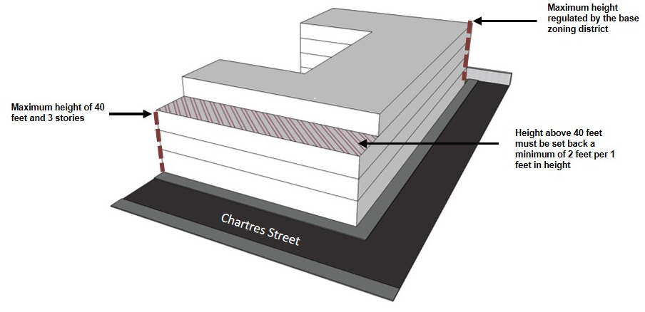
i. Properties with street frontage along Chartres Street between Homer Plessy Way and Desire Street are permitted a maximum building height of forty (40) feet with a maximum of three (3) stories along that street frontage. Any additional height above forty (40) feet shall be setback from the front property line at Chartres Street at a minimum distance of two (2) feet for every one (1) foot above forty (40) feet up to a maximum allowed by the base zoning district.
Figure 18-1: Building Height Stepback Requirement for Properties on the Riverside of Chartres Street (RIV-3 District)
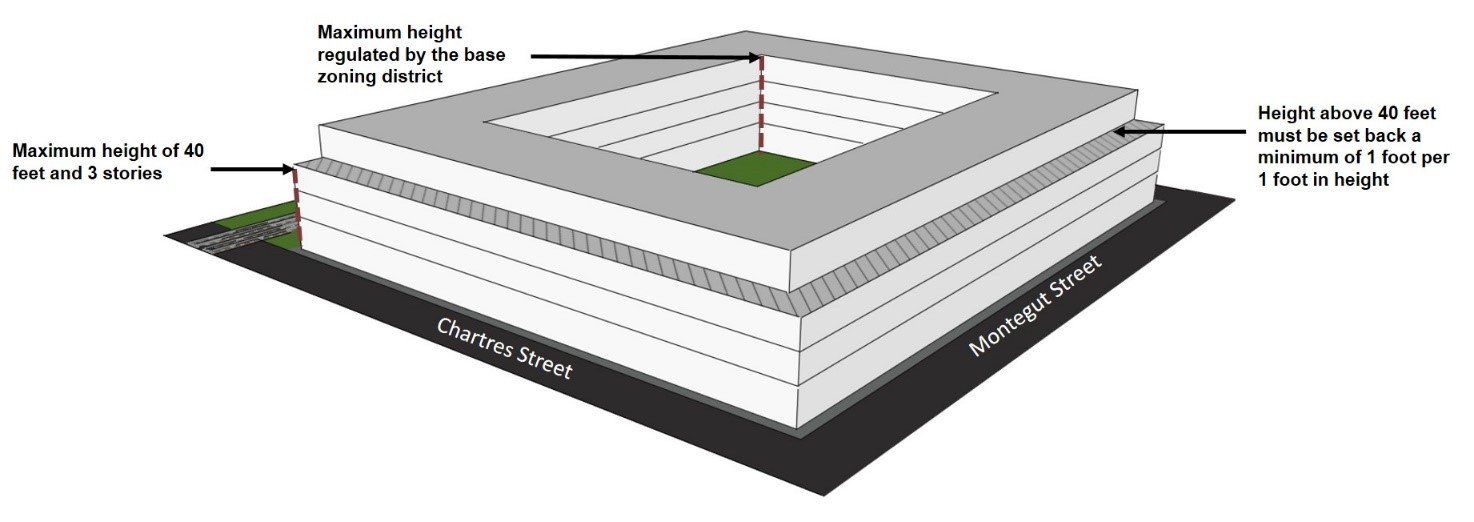
ii. Properties bounded by Homer Plessy Way and Chartres, Montegut, and Dauphine Streets are permitted a maximum building height of forty (40) feet with a maximum of three (3) stories along Montegut Street, Chartres Street, and Dauphine Street frontages. Any additional height above forty (40) feet shall be setback from the property line a minimum distance of one (1) foot for every one (1) foot above forty (40) feet up to a maximum allowed by the base zoning district.
Figure 18-2: Building height Stepback Requirements for Properties Bounded by Homer Plessy Way and Chartres, Montegut and Dauphine Street (RIV-3 District
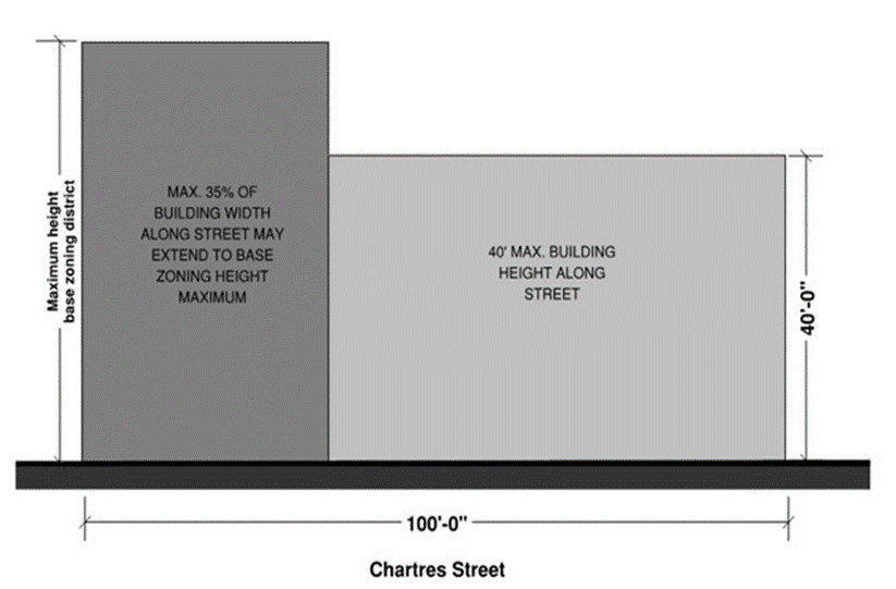
iii. Development sites with more than 100 feet of frontage may increase a portion (up to thirty-five percent (35%) of its street frontage) of their building height, to a maximum allowed by the base zoning district.
Figure 18-3: Allowable Building Height Variation Along Street
b. Flat roofed structures should provide an adequately-sized parapet in order to mitigate the sight of rooftop equipment.
c. Where provided as accessory flat roof features, open spaces located on roofs shall be excluded from the calculation of building height and gross floor area in accordance with Section 21.6.O.
Adopted by Ord. 27,674 MCS, §2, March 6, 2018, Zoning Docket 085-17; Ord. 28177, Sept. 5, 2019, ZD 41/19
18.13.H.3 Use Standards and Use Restictions
a. Required Uses for Ground Floors
Multi-family development that is forty-thousand (40,000) square feet or more in gross floor area shall allocate at least twenty percent (20%) of the floor area of the ground story for commercial or institutional use, subject to the permitted and conditional uses of the base zoning district. Floor area does not include corridors or other spaces used in common with other uses. Single-family dwellings, two-family dwellings, educational facilities, and townhouses are exempt from this use restriction.
b. Commercial Use Floor Area Limitation
In the RIV-3 Bywater Sub-District, each ground floor commercial use shall not exceed five thousand (5,000) square feet of total floor area unless approved as a conditional use.
c. Short-Term Rental Restriction
Commercial Short-Term Rentals are prohibited within the RIV-3 Bywater Sub-District.
Adopted by Ord. 27,674 MCS, §2, March 6, 2018, Zoning Docket 085-17
18.13.I RIV-4 Marigny Sub-District Standards
The following standards apply to the landside of the floodwall or levee:
Adopted by Ord. 27,674 MCS, §2, March 6, 2018, Zoning Docket 085-17
18.13.I.1 Design Standards
a. Buildings shall generally be built along the lot lines on streets parallel to the river.
b. Building facades along major access corridors, those parallel to the river, shall include architectural features to avoid the appearances of blank walls facing the street. These include, but are not limited to changes in the wall plane of at least six (6) inches such an offset, reveal, pilaster, or projecting rib, changes in wall texture or masonry patterns, colonnade, columns, or pilasters.
c. Buildings shall be designed with galleries, awnings, canopies, and other weather protections devices.
d. Pedestrian and main entrances shall be located on the streets parallel to the river.
e. First floor residential units located adjacent to the public street shall have individualized and direct entrances from the public sidewalk at the front (primary street) elevation, where possible.
f. Curb cuts and vehicular access areas should be located on secondary side streets, perpendicular to the river, if possible.
g. Areas dedicated to servicing and loading and vehicular access shall be minimized through the use of shared infrastructure and efficient layouts. Garage doors and service openings shall be minimal in size, and recessed or screened in order to be minimally visible from the street.
h. Developments shall contribute to traffic signaling or lane striping if deemed necessary by the Director of the Department of Public Works.
i. Developments shall include a type of neighborhood amenity or public open space such as, but not limited to, landscaped public open space, public art, mural, dog park, transit shelter, public rofftop access, restaurant with outdoor seating, or public plaza, subject to the Public Plaza Standards and Guidelines contained within Section 17.5.F.2 except that the plaza may be located more than three (3) feet above the adjacent sidewalk area in order to provide better views.
j. Historic buildings shall be retained and reused to the greatest extent possible.
Adopted by Ord. 27,674 MCS, §2, March 6, 2018, Zoning Docket 085-17
18.13.I.2 Building Heights
a. Stepbacks
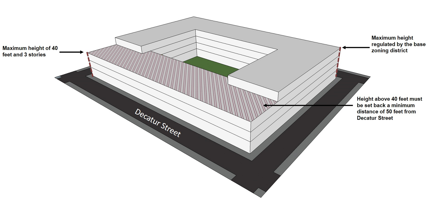
i. Properties with street frontage located along Decatur Street between Elysian Fields Avenue and Saint Ferdinand Street, and street frontage on Chartres Street between Saint Ferdinand and Homer Plessy Way are permitted a maximum building height of forty (40) feet with a maximum of three (3) stories along the Decatur or Chartres Street frontage. Additional height above forty (40) feet shall be setback from the front property line at Decatur or Chartres Street at a minimum distance of fifty (50) feet up to a maximum allowed by the base zoning district but the additional height shall be set back a minimum distance of fifty (50) feet from the Decatur Street or Chartres Street frontage.
Figure 18-4: Building Height Stepback Requirement (RIV-4 District)
ii. Development sites with more than one-hundred (100) feet of frontage along Decatur or Chartres Streets may increase a portion (up to thirty-five percent (35%) if its primary street frontage) of their building height, to a maximum allowed by the base zoning district.
Figure 18-5: Allowable Building Height Variation Along Street

b. Flat roofed structures should provide an adequately-sized parapet in order to mitigate the sight of rooftop equipment.
c. Where provided as accessory flat roof features, open spaces located on roofs shall be excluded from the calculation of building height and gross floor area in accordance with Section 21.6.O.
Adopted by Ord. 27,674 MCS, §2, March 6, 2018, Zoning Docket 085-17; Ord. 28177, Sept. 5, 2019, ZD 41/19
18.13.I.3 Use Standards and Use Restriction
a. Required Uses for Ground Floors
Multi-family development that is forty-thousand (40,000) square feet or more in gross floor area shall allocate at least twenty percent (20%) of the floor area of the ground story for commercial or institutional use, subject to the permitted and conditional uses of the base zoning district. Floor area does not include corridors or other spaces used in common with other uses. Single-family dwellings, two-family dwellings, educational facilities, and townhouses are exempt from this use restriction.
b. Commercial Use Floor Area Limitation
In the RIV-4 Marigny Sub-District, each ground-floor commercial use shall not exceed five thousand (5,000) square feet of total floor area unless approved as a conditional use.
c. Short-Term Rental Restriction
Commercial Short-Term Rentals are prohibited within the RIV-4 Marigny Sub-District.
Adopted by Ord. 27,674 MCS, §2, March 6, 2018, Zoning Docket 085-17; Ord. 28177, Sept. 5 2019, ZD 41/19